Livingston County, MO Cemeteries:
This list starts at the NW corner of the county with Jackson Township and moves south to Sampsell. It continues south until reaching Carroll County and then jumps north to Cream Ridge, continuing this track through all the townships to Grand River Township. Links are provided, but many of these cemetery transcriptions are part of other sites. Please use your "BACK" button to return to this page.
My description of where these cemeteries are located is a composite of the information in the book Livingston County History Celebrating 150 Years 1821 -1981 and from the descriptions provided by Marie Dryden as listed on Fred Wood's Livingston County Cemetery pages and the locations of cemeteries platted on the 1930 Livingston County Plat Map. There may be errors. If so, please contact me with the correct information and documentation locating the cemetery.
Several sections of the 1930 Plat Map are shown below with a number and the name of the cemetery. The numbers shown in parentheses below refer to that location on the maps available at the following links. Note: the the shape of the townships in Livingston County are not square or rectangular, rather they are bounded by the two large rivers, the Grand and Thompson Rivers, flowing through the county. Therefore the survey township lines and the county townships do not exactly coincide.
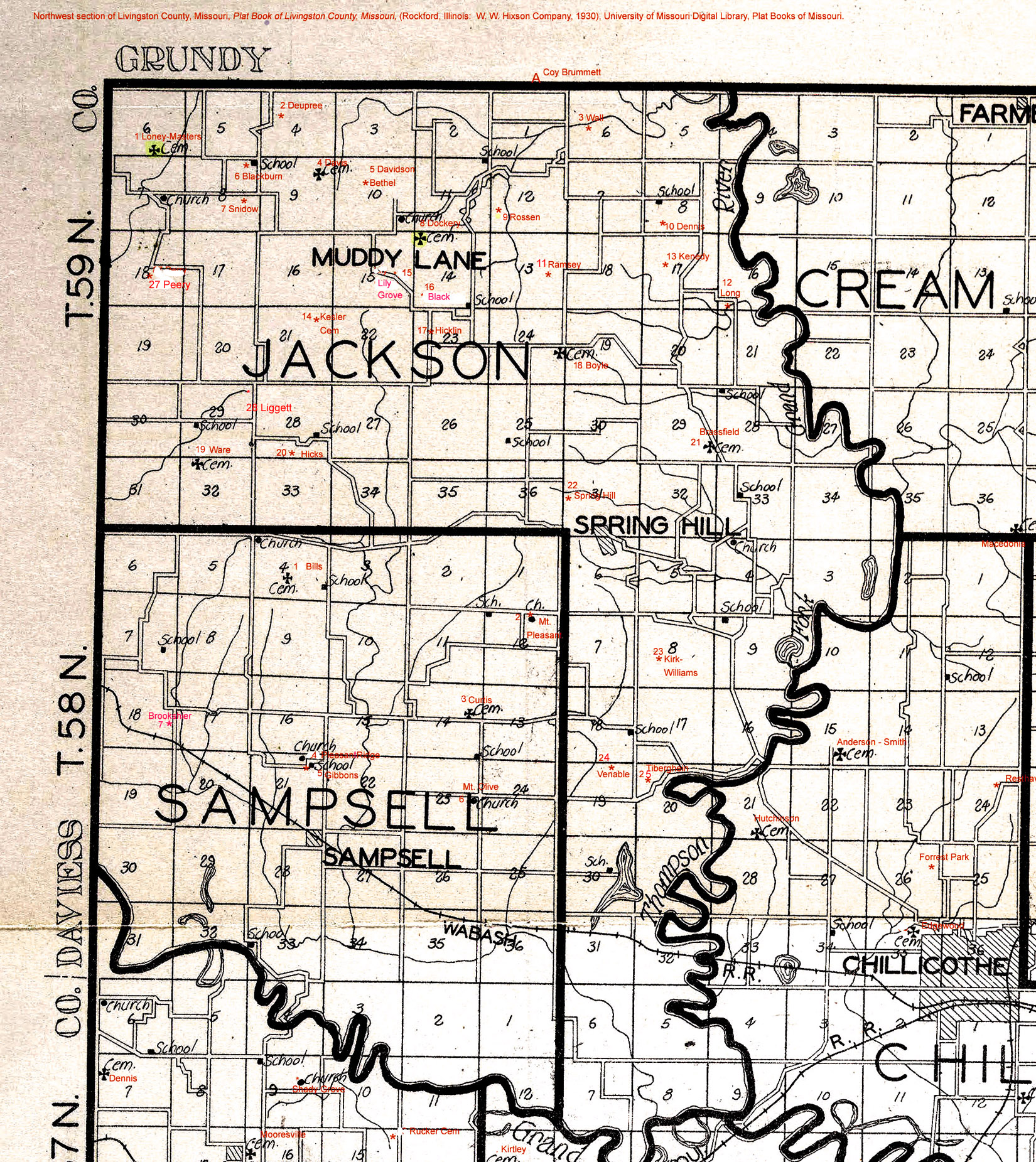
Jackson Township is in the NW corner of Livingston County. Its legal description includes Township 58 and 59 North and Range 24 and 25 West. It borders Grundy County to the north and Davies County to the west. The east boundary line is the Thompson River and the south boundary is a very narrow point where the Grand and the Thompson Rivers meet. The general shape of this township is an upside down "L."
Loney-Masters (1) - Located in the SE 1/4 of Section 6, Township 59N, Range 25W; Jackson Township. From Jamesport take Route F east to Route U. Go south on Route U about 2.5 miles. It turns east, continue to gravel road and go south to next gravel road. Turn west and the cemetery is about 1.25 miles west, located on north side of road. No maintenance.
Deupree (2) - Located NW 1/4 Section 4, Township 59, Range 25W; Jackson Township. From Jamesport take Route F east to SW 68th (gravel road) and turn south. Cemetery plot should be on east side of road. Apparently, only a single grave there.
Walls Cemetery (3) - Located in West 1/2 of Section 6, Township 59N, Range 24W; Jackson Township. Take Route W north from Highway 190 to creek bottoms, continue east about 1/2 mile to cemetery on hill. Cemetery is near Grundy County line.
Also see Find A Grave.
Davis Cemetery (4) - Located in NE 1/4 Section 9, Township 59N, Range 25W in Jackson Township. About 1.25 miles south of Grundy County line and 2.25 miles east of Daviess County line. [Transcription not available.]
Davidson - Bethel (5) - Located Sec 10, Township 59N, Range 25W. About 1.5 miles south of Grundy County Line. [Transcription not available.]
Blackburn (6) - Located in NE 1/4 Sec 8, Township 59N, Range 25W; Jackson Township. From Jamesport take Route F east to Route U. South on Route U to where it turns east. Cemetery should be in SW corner where road turns sharply south. [Transcription not available.]
Snidow (7) - Located in SE 1/4 Sec 8, Township 59N, Range 25W; Jackson Township about 1/2 mile south of Blackburn Cemetery on Route U. [Transcription not available.]
Dockery (8) - Located in Section 11, Township 59N, Range 25W; Jackson Township. About 1 mile north
of Lily Grove Church.
Also see Find A Grave.
Rossen (9) - Located SE 1/4 Section 12, Township 59N, Range 25W; Jackson Township. About 2 miles North of junction of Routes W and Y, then West.
Also see Find A Grave.
Denness (10) - Located in South Section 8, Township 59N, Range 24W; Jackson Township. From Grundy County line on Route W south about 1.5 miles then east on gravel road 1.5 miles, road turns south.
Also see Find A Grave.
Ramsey (11) - Located SE 1/4 Section 13, Township 59N, Range 25W; Jackson Township. About 1 mile North of junction Routes Y and W, then left through field about 1/2 miles.
Also see Find A Grave.
Long (12) - Located SW 1/4 Section 16, Township 59N, Range 24W; Jackson Township.
Also see Find A Grave.
Kenedy (13) - Located in the NE 1/4 Section 17, Township 59N, Range 24W; Jackson Township. [
Transcription not available.]
Kessler (14) - Located NE corner Section 21, Township 59N, Range 25W, Jackson Township. On M
issouri Conservation land.
Also see Find A Grave.
Lily Grove (15) - Located East edge Section 14, Township 59N, Range 25W; Jackson Township West on Hwy 190, North on Route A, about 2 miles NW of junction with Route W.
Also see Find A Grave.
Black (16) - Located Section 15, Township 59N, Range 25W, Jackson Township, On State Route A, 1.75 miles NW of junction of State Routes A and W.
Also see Find A Grave.
Hicklin (17) - Located in NW 1/4 Section 23, Township 59N, Range 25W; Jackson Township. About 1.25 miles west of junction of Highways A and W.
Also see Find A Grave. Boyle (18) - Located in SE 1/4 Section 24, Township 59N, Range 25W; Jackson Township. Near the junction of Routes Y and W.
Also see Find A Grave. Ware (19) - Located NW 1/4 Sec 29, Township 59N, Range 25W; i
n Jackson Township. About 3 1/2 miles North of Hwy 190 on Route U.
Hicks (20) - Located SW 1/4 Sec 28, Township 59N, Range 25W; Jackson Township. About 3 1/2 miles North of Hwy 190 on Route U, in pasture on farm. At one time had many stones. No stones remain at this cemetery.
Also see Find A Grave.
Brassfield (21) - Located in the SE 1/4 of Sec 29, Township 59N, Range 24W; Jackson Township. On Highway Y.
See Find A Grave.
Springhill (22) - Located in the SW 1/4 of Sec 31, Township 59N, Range 24W; Jackson Township. About 3 miles north of Highway 190 on Route A on right side.
Also see Find A Grave.
Kirk - Williams (23) - Located SW 1/4 Sec 8, Township 58N, Range 24W; Jackson Township West 1/4 mile from junction of Hwy 190 and Route Y, then North on gravel road to last house, then walk 200 yards southeast to cemetery.
Also see Find A Grave.
Venable (24) - Located in NE 1/4 of Sec 19, Township 58, Range 24W; Jackson Township. [Note: This description does not match the location shown on the map in the history book. "At the junction of Routes Y and W East 100 yards." According to this book the location is about 1/4 mile west of the junction of Highways 190 and Y and about 1/4 mile south on gravel road. Straight south of Kirk - Williams Cemetery. According to this book the cemetery is across the road from Tiberghein. More research needs to be done to determine what is correct.] Old, abandoned, reduced by bulldozer from about 1/2 acre, about 8 stones.
Also see Find A Grave.
Tiberghein (25) - Located in NW 1/4 Sec 20, Township 58N, Range 24W; Jackson Township. About 1/4 mile West of junction Hwy 190 and Route Y, South about 1/2 mile, on East side of road across from Gibbs Cemetery. [Note: According to history book it is across from Venable Cemetery.]
Gus Curtis Cemetery (26) - The location of this cemetery is uncertain. According to information provided by Marie Dryden of the historical society, "This cemetery is located in Jackson Township, Section 18, T?N, R24W
on what is known (1965) as the Gus Curtis place; there is no fence left.
The cemetery is back in a pasture."
Peery (27) - Located in NE 1/4 Section 18, Township 59N, Range 25W; Jackson Township.
Liggett (28) - Located i
n NE 1/4 Section 29, Township 59N, Range 25W, Jackson Township. On private land.
Sampsell Township is smaller than Jackson Township and lies south and west of Jackson Township. It is in Township 58N and Range 25W. According to History of Livingston County - Celebrating 150 Years there are only 7 cemeteries in this township.
Bills (1) - Located in Section 4, Township 58N, Range 25W; Sampsell Township. North from Highway 190 on Route U about 2 miles. Cemetery is in a field.
Mt. Pleasant (2) - Located in NE 1/4 Section, Township 58N, Range 25W; Sampsell Township. North of Highway 190 about 1.5 miles and about 1/2 mile west of Highway A.
Curtis (3) - Located in NE 1/4 Section 14, Township 58N, Range 25W; Sampsell Township. About 5 miles east of county line on Hwy 190 (north side of road) or 1.25 miles west of junction of Highways 190 and A.
Pleasant Ridge (4) - Located NE 1/4 Section 21, Township 58N, Range 25W; Sampsell Township. From junction of Highways A and 190 west 3 miles and south 1/2 mile then west 1/4 mile to Pleasant Ridge Church.
Gibbons (5) - Located NE 1/4 Section 21, Township 58N, Range 25W; Sampsell Township. From junction of Highways A and 190 west 3 miles and south 1/2 mile then west 1/4 mile to Pleasant Ridge Church. About 1/4 mile West of Pleasant Ridge Church.
Mt. Olive (6) - Located NE 1/4 Section 23, Township 58N, Range 25W; Sampsell Township. About7 miles west of Route 190 to Route N, south on N 1 mile, east 1 mile across from the Mt. Olive Church.
Brookshier (7) - Located Section 18, Township 58N, Range 25W; Sampsell Township. About 1 mile East of
Daviess County line on Hwy 190, then South down a private lane to family
plot on Harold Litton farm.
Mooresville Township is bounded on the north by the Grand River.
Gaunt (1) - Located in SW 1/4 Section 7, Township 57N, Range 25W; Mooresville Township. Northwest of Mooresville about 1.5 miles N and 1 mile W and about 1 mile from county line.
Shady Grove (2) - Located SE/4 Section 9, Twp 57N, R 25, Mooresville Twp
Rucker (3) - Located in NW 1/4 Section 15, Township 57N, Range 25W; Mooresville Township. About 1 mile north and 2 miles east of Mooresville.
Mooresville (4) - Located on east edge of town of Mooresville.
Mooresville Christian Church Cemetery (5) - located in Section 21, Township 57N, Range 25W; south part of Mooresville, MO
Kirtley (6) - Located SW 1/4 Section 14, Township 57N, Range 25W; Mooresville Township. A small plot
with only two known graves - about 10 ft by 15 ft, was once surrounded by a rock wall 12 inches high.
Shannon Compton (8) - Located in SE 1/4 Section 21, Township 57N, Range 25W; Mooresville Township.
Toner (1) - Located in N 1/2 Section 6, Township 56N, Range 25W; Monroe Township. About 1/2 mile from county line. From Ludlow it is two miles West on Route DD, North three miles and then 1/2 West to Sturgeon sawmill.
Bethel (2) - Located in NW 1/4 Section 5, Township 56N, Range 25W; Monroe Township. From Ludlow it is two miles West on Route DD, North three miles.
McCroskie (3) - Located in NE 1/4 Section 5, Township 56N, Range 25W; Monroe Township. From Ludlow it is 3 miles north on Route D, 1 miles west then south less than 1/4 mile.
Gregory also known as Lawson (4) - Located in NW 1/4 Section 2, Township 56N; Range 25W; Monroe Township. From Ludlow 3 miles north on Route D, 1.5 miles east on south side of road.
Anderson - Critchfield (5) - Located in middle Section 9, Township 56N; Range 25W; Monroe Township. From Ludlow 2 miles north on Route D, then west on gravel road about 0.75 miles and south 0.5 miles. On east side of road.
Monroe (6) - Located in NW 1/4 Section 15, Township 56N, Range 25W; Monroe Township. From Ludlow north on Route D 1 mile. At intersection of D and D.
Jarvis (7) - Located in NE 1/4 of Section 18, Township 56N, Range 25W; Monroe Township. About 2 miles West of
Ludlow then north about 1/8 mile; in a field.
Collar Cemetery (8) - Located Section 30, Township 56N, Range 24W, M
onroe Township, About 2 1/2 miles South of Dawn, MO.
Coy-Brummett (A) - Located in Grundy County in Jefferson Township; Section 36, Township 60N, Range 25W.
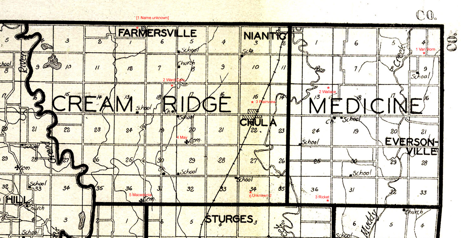
Name unknown [Farmersville] (1) - Located in NW 1/4 Section 1, Township 59N, Range 24W; Cream Ridge Township. Near Farmersville.
Ward (2) - Located in NE 1/4 Section 18, Township 59N, Range 23W; Cream Ridge Township. From Chula west 3 miles on Route K, north 1 mile on County Road 247, then west 1/2 mile on County Road 200.
May (4) - Located in SW 1/4 Section 20, Township 59N, Range 23W; Cream Ridge Township. From junction of Highway 65 and Route K east 1/2 mile, south on County Road 245 1 mile, then east on east 1/2 mile on County Road 210.
Macedonia (5) - Located in NE 1/4 Section 18, Township 59N, Range 23W; Cream Ridge Township.
2nd Cemetery (6) - name not known - Located in middle Section 34, Township 59N, Range 23W; Cream Ridge Township.
Cemeteries in Medicine Township
Van Horn (1) - Located in SW 1/4 Section 4, Township 59N, Range 23W; Medicine Township. On K Highway about 1 mile south of Grundy County line and 0.5 mile west of Linn County line.
Wallace (2) - Located in NE 1/4 Section 13, Township 59N, Range 23W; Medicine Township East of Chula, MO on Route K about 3 miles and 1/2 mile north.
Ricket (3) - Located in SE 1/4 Section 36, Township 59N, Range 23W; Medicine Township. About 6 miles east of Highway 65 or 3 miles west of Linn County line.
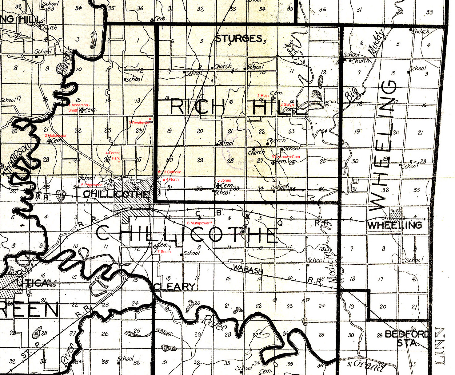
Ross (1) - Located NE/4 Section 15, Twp 58, Range 23W, Rich Hill Township East on Route V 5 1/4 miles, East 1 mile on gravel road.
Slagle (2) - Located SW 1/4 Section 14, Township 58N, Range 23W; Rich Hill Township 4 3/4 miles East from Hwy 65 and 4 miles north of Highway 36. T
ake Route V, East to 2nd gravel road on left.
Catholic (3) - Located in SW 1/4 Section 30, Township 58N, Range 23 West; Rich Hill Township. About 2 miles north of Highway 36 and 3/4 mile east of Highway 65. On County Road 232.
North (4) - Located Section 31, Township 58N, Range 23W; Rich Hill Township. A
bout 2 miles east of Highway 65. Take Route V to Broadway, North to Trenton Road, East to North side of Airlane Trailer Court, across railroad tracks.
Jones (5) - Located in NW 1/4 Section 33, Township 58N, Range 23W; Rich Hill Township.
Anderson-Smith (1) - Located in SE 1/4 Section 15, Township 58N, Range 24W; Rich Hill Township. About 2.5 miles west of Highway 65.
Hutchinson (2) - Located in SE 1/4 Section 18, T
ownship 58N, Range 24W; Chillicothe Township. About 2.5 miles west of Highway 65. On Highway 190.
Resthaven (3) - Located in NE 1/4 Section 24, Township 58N, Range 24W; Chillicothe Township. On west side of Highway 65.
Forrest Park (4) - Located in NE 1/4 Section 26, Township 58N, Range 24W; Chillicothe Township. At the SW corner of Golf Course in Chillicothe near swimming pool.
Edgewood also known as Mt. Sinai (5) - Located in NW 1/4 Section 35, Township 58N, Range 24W; Chillicothe Township. It is located in the Northwest part of Chillicothe. West from Highway 65 on Bryan Street to Cemetery Lane turn right.
Mumpower (6) - Located in SE 1/4 Section 5, Township 58N, Range 23W; Chillicothe Township. About 2.5 miles east of junction of Highways 36 and 65. About 1/4 mile north of Highway 36.
South (7) - Located in the SW 1/4 of Section 7, Township 57N, Range 23W; Chillicothe Township. East of Chillicothe on Hwy 36 to 1st road past railroad overpass, South 1/2 mile.
Cemeteries in Green Township
Stone (1) - Located SW 1/4 of Section 18, Township 57N, Range 24E; Green Township 1 mile West of Utica.
Cemetery Unknown Name (2) - Located in SW 1/4 Section 13, Township 57N, Range 24W; Green Township. About 2.5 miles west of Utica and 0.5 miles north.
Utica (3) - Located in NE 1/4 Section 19, Township 57N, Range 24W; Green Township. South side of Highway 36 at Utica junction.
Guthridge (4) - Located in SW 1/4 Section 32, Township 57N, Range 24W; Green Township. About 2.5 miles south of Utica. Take Route C south for 1.5 miles then county road for 0.5 miles south.
Cemeteries in Blue Mound Township
Christison (1) - Located in NE 1/4 of Section 3, Township 56N, Range 24W; Blue Mound Township. West of Route Z about 1 mile and 0.5 miles south of Highway 65 and Route Z junction.
Elliott (2) - Located in SW 1/4 of Section 8, Township 56N, Range 24W; Blue Mound Township. About 1 mile East of Dawn. Take Route C east to County Road, then North on private lane along field, walk 1/4 mile North to cemetery in timber.
Welsh (3) - Located in NE 1/4 of Section 21, Township 56N, Range 24W; Blue Mound Township. About 0.5 miles south of Route C and about 2 miles east of Dawn.
Blue Mound (4) - Located in NE 1/4 of Section 26, Township 56N, Range 24W; Blue Mound Township. Located on Route Z about 0.5 miles north of Blue Mound.
Cemeteries in Fairview Township
Burnside (1) - Located in SE 1/4 of Section 34, Township 57N, Range 23 W; Fairview Township. From Avalon go north on Route JJ 2 miles, then 1 mile west, then north on County Road 1 mile and west 0.5 miles. On north side of road.
Matthews (destroyed) (2) - Does not exist any more. Was located in SW 1/4 of Section 18 in Township 56N, Range 23W; Fairview Township. About 1.25 miles east of Route Z and 2.75 miles west of Highway 65 and 4 miles north of Carroll county line.
Mayberry (3) - Located in SE 1/4 Section 20 in Township 56N, Range 23W; Fairview Township. About 1.5 miles west of Highway 65 on County Road.
Avalon (4) - Located in NW 1/4 of Section 24, Township 56N, Range 23W; Fairview Township. About 1/2 mile south of Avalon on County Road.
Arkadelphia (5) - Located in SW 1/4 of Section 26, Township 56N, Range 23W; About 2 miles south of Avalon on County Road.
Munro (6) - Located in west of the Fountain Grove Wildlife Area and north of Avalon on a country road. It is approximately 2.5 - 3 miles west of Bedford and about 2 miles north of Avalon.
Cemeteries in Wheeling Township
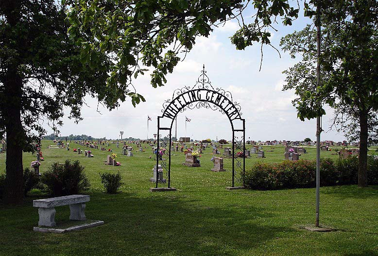
Wheeling (1) - Located in SE 1/4 Section 5, Township 57N, Range 22W; Wheeling Township. South of Wheeling about 1 mile. On north side of Highway 36 west of Junction of 36 and Route B.
Wheeling Cemetery at Find A Grave
Leopolis (2) - Located in the NW 1/4 of Section 7, Township 58N, Range 22W; Wheeling Township. It is located five miles north of Wheeling on Route B, then west two miles.
Cemeteries in Grand River Township
Bedford (1) - Located in SW 1/4 of Section 4, Township 56N, Range 22W; Grand River Township. About 1/4 mile Southwest of Bedford.
Wolfskil (2) - Located SW 1/4 of Section 11, Township 56N, Range 22W; Grand River Township. Approximately 1 1/2 miles south of Bedford on C
ounty Road. Go 3/4 mile east then 1/3 mile north.
Silvey (3) - Located NW/4 Section 18, Township 56N, R 21W; Grand River Township. From Avalon go east on Route H to Highway 139, East about 2 miles, 2 miles North of 139.
Fairland (4) - This cemetery is located in Section 22, Township 56N, Range 22W; Grand River Township. About nine miles south of Chillicothe on Highway 65, then east six miles on Route H. Located on the North side of the road.
Walden (5) - Located in SW 1/4 of Section 21, Township 56N, R 22W; Grand River Township. From Avalon go east on Route J to H. Continue east to 1st gravel road go south 1.5 miles, then East about 1/4 mile, walk 1/2 mile North from old barn, on North side.
Ireland (6) - Located in NW 1/4 Section 19, Township 56N, Range 21W; Grand River Township. From Avalon go east on Route H to Highway 139. Go east on Highway 139 about 2 miles. Then north on County Road to cemetery about 0.5 miles.
Leaton (7) - Located NW 1/4 of Section 29, Township 56N, Range 21W; Grand River Township. From Avalon take Highway H east to Highway 139, continue East almost to river. In Eastern portion of the Section at end of lane.
Cameron (8) - Located Section 27, Township 56N, Range 22W, Grand River Township, North of Hale, MO on State Hwy 139.
Cemeteries Location Not Known
Carlisle - Location not known by webmaster.
Note to Contributors to this Site!
If you have information to contribute, please e-mail me: Sharlene Miller with your information and if it is appropriate, I will be happy to add it to the website.

