
HOME | Bibliography/Indexes | Cemetery
Listings & Photos | Census | Links
of Interest
Lookups | Maps | Military | Queries & Surnames | Vital
Statistics | Where to Research
Maps
Check back for additional maps later in 2005.
General County Map: 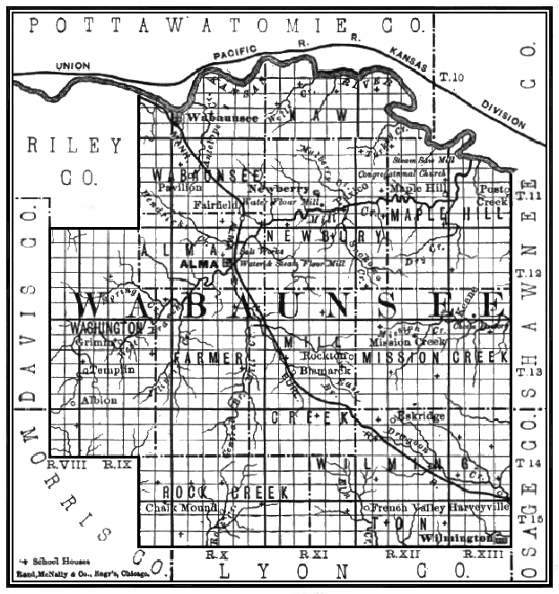 |
||
| plat maps | Plat maps (landowner maps) of the entire county were made in 1885, 1902 and 1919. The Kansas State Historical Society has these maps on microfilm and they are available through interlibrary loan. The Topeka and Shawnee County Public Library has the 1885 and 1902 maps in print form. The Wabaunsee County Museum also has several of these maps available. The Topeka Genealogical Society has published a name index to the 1919 map. | |
| county maps | The Kansas Department of Transportation has high resolution maps (the General Highway map) of Wabaunsee County and the towns of Alma, Alta Vista, Eskridge, Harveyville, Maple Hill, McFarland and Paxico. These maps can be downloaded for free on their website and a print copy can be purchased for a small fee. The nice thing about these maps are they show all of the roads in the county and identify and label most of the cemeteries. I consider their Wabaunsee County map a must when visiting the rural cemeteries. | |
| historic maps | The USGenWeb Archives Digital Map Library has several historic maps of Kansas (and the rest of the country too). They are always adding more maps, so check back occasionally. | |
 |
Copyright © 2005. All Rights Reserved by USGenWeb Project and Wabaunsee County Webmaster, unless otherwise specified. Material on this page may be used for educational or non-profit purposes as long as the copyright line above is included with the material. If you have any questions, comments, updates and/or corrections about the site, please contact Mickey Delfelder. |
 |