

|

|
|
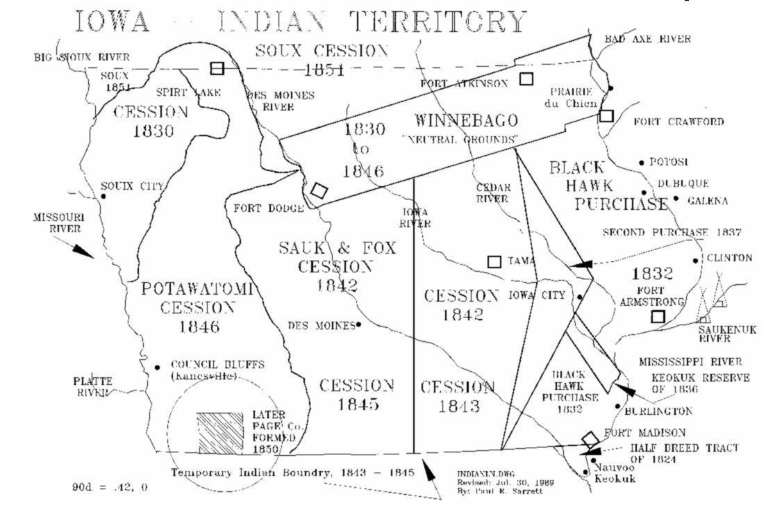 |
1830-1845 Indian Territory - present-day IOWA This Map is of the Indian Territory, showing the location of Indian tribes, and date of "Cession" or "Stolen" by the White man. Drawn by Paul R. Sarrett, Jr. with Consolation from Uncle George K. ANNAN ~ Jul 20, 1989. |
 |
1838-1846 IOWA Territory This Map is of the IOWA Territory, showing the location of Indian tribes, and Boundries. Drawn by Paul R. Sarrett, Jr. with Consolation from Uncle George K. ANNAN ~ Oct. 02, 1988. |
 |
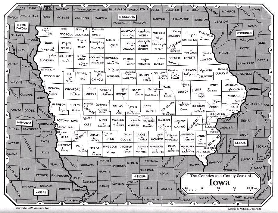
1856 ~ IOWA Engraved by: G.W. COLTON; Printed and Mounted by: J.H. Colton & Co., No. 172, William Street, New York, NY. [Page #47] Map showing, County lines; Section lines; Major City/Towns; County Seats; Post Offices; Railroads and name of Roads. |
 |
1859 ~ Johnson's Map of Illinois, Iowa, & Missouri Author: Johnson, A. J. (Alvin Jewett, 1827-1884). Published: New York, c1857, 1859. Detailed general map which includes drainage place names, roads, railroad, counties, and townships. CALL NUMBER: G4061.P3 1859 .J6 RR 124 REPOSITORY: Library of Congress Geography and Map Division Washington, D.C. 20540-4650 USA  <---
See: American Memory.com Maps Collection (Off Site!) <---
See: American Memory.com Maps Collection (Off Site!) |
 |
1864 ~ Johnson's Map of Iowa, & Nebraska Author: Johnson, A. J. (Alvin Jewett, 1827-1884). Publisher: Johnson & Ward, New York: A. J. Johnson |

|
1875 ~ A. T. Andreas' Illustrated Historical Atlas of the State of IOWA By: A. T. (Alfred Theodore Andreas, (1839-1900) Engraved & printed by Chas. Shober & Co., Props. of Chicago Lithographing Co. Published by: Andreas Atlas Co., Lakeside Building, Chicago, Ills. Note: Landowners identified! <---
See: 1875 ~ Page County, Townships (On Site)
|

|
1875 ~ A. T. Andreas' Sectional map, Pg. 20, of IOWA By: A. T. (Alfred Theodore Andreas, (1839-1900) Engraved & printed by Chas. Shober & Co., Props. of Chicago Lithographing Co. Published by: Andreas Atlas Co., Lakeside Building, Chicago, Ills. Note: Showing Civil & Congressional Townships, all Towns, Post 0ffice, Etc. |

|
1877 ~ Gray's New Map of IOWA by: Frank A. Gray, Publisher: Philadelphia: O.W. Gray & Son |

|
1881 ~ Railroad Map of IOWA Publisher: Railroad Commissioners, Des Moines, 1881 <---
See: American Memory.com Maps Collection (Off Site!) |

|
1853 ~ 1858 Purchase Land Abstract Some 1853 Land Abstracts for Page County ) issued out of the Public Land Office at Council Bluffs, more will be forth coming. ..prs |
|
|
1875 Land Owners Has all Township maps, with owners name and amount of acres, showing sections, P.O where lived, has date, County & State where/when came to Page Co. |
![]()
|
|
|
|
|
 These records are dedicated to one of my best friends, my Uncle:
 <---
George K. ANNAN, 1915-1996, age 81yrs <---
George K. ANNAN, 1915-1996, age 81yrsI Compiled and self Published some various Towns & Townships Maps records in Jun. 28, 1986. Uncle George, would tutor me for hours, on the struture of Townships, we would visit various historical sites in Page County and he would explain to me a lot of his first had experiance. Uncle George, grew up in rual area of Yorktown, Page Co., Iowa. He was a large land owner, and Farmer, and was Commissioner on the Page County Soil Conservation District for over 30 years; Director of the Iowa Association of Soil Conservation District Commissioners; Served on the State Soil Conservation Committee; Member of the Lions Club of Clarinda, Iowa; Was a 4-H leader for many years; Helped organize the Lincoln Leaders Boys 4-H Club. Received many awards as a commissioner, Outstanding Commissioner for Region VII in 1960; Watershed Achievement Award in 1979; Emmett ZOLLARS Award in 1974; Page Co., Goodyear Tire & Rubber Co. Award in 1976; just to name a few. ....by Paul R. Sarrett, Jr. |
 |
E-Mail: Paul R. Sarrett, Jr., Auburn, CA. Friends of Page County, President |
 Sep. 10, 2011;