|
"M"
- "Z" CEMETERIES OF NACOGDOCHES COUNTY, TEXAS |
 |
INFORMATION,
NOTES, LEGEND, AND ABBREVIATIONS |
|
|
|
Some of these are links to web pages authored by other
researchers, some are links to information submitted to the
USGenWeb
Archives Project, and some are links to projects now
under way to photograph headstones in Nacogdoches County
cemeteries.
NOTE: Each researcher tries to be as accurate as possible in
making transcriptions, but the condition of headstones often
makes it easy to incorrectly transcribe a date or spelling of a
name. All genealogy data should be verified with primary sources
to confirm names and dates. Most of the transcribers have email
contact information on their web pages to be used if you suspect
an error in the transcript.
|
|
|
If you know of other sites with Nacogdoches County, Texas
cemeteries
or if you'd like to contribute information please let
us know. If you are working on a cemetery in Nacogdoches
County please let me know. Although having multiple transcripts
of the same cemetery can be used to compare and reduce errors,
some people prefer to work on a cemetery that has not yet been
transcribed to offer a greater depth of data to the researchers.
When someone notifies me they plan to transcribe a cemetery I
will place a note below indicating that cemetery is currently
being worked.
|
|
Until August 2004 we had 117 cemeteries on this list. We now
have 180 cemeteries listed, plus many name variations, thanks to
Cathy Pulley whose masters thesis on Cemeteries of Nacogdoches
County, Texas Since 1542 lists all known cemeteries of the
county. Information on all cemeteries is included here with her
permission. Many thanks to Cathy for her hard work over several
years to gather this information. Dates of establishment of
cemeteries are from Cathy's thesis; some dates are based on the
oldest marker in the cemetery although there may have been
indications of earlier burials.
Note: There is more information on most of these cemeteries in
Cathy's thesis than what has been included on this web page so
you might want to read her thesis at Stephen F. Austin State
University in Nacogdoches if you get a chance.
|
|
Thank you to all of the volunteers that have contributed much of
their time and efforts performing surveys and transcriptions.
Also, thank you Carolyn Ericson for allowing us to use the
cemetery location descriptions from her Nacogdoches County
Cemetery Transcription books. Some of these are being
updated as I get driving directions to the cemeteries.
|
|
For cemeteries on private property, only a general location is
given unless the property owner has given permission to publish
the location. The general locations will help
determine if a cemetery is near the residence of ancestors and
might be a possible burial place for them. One should be
aware that some of the driving directions have been compiled
from several sources (Pulley, Ericson, and Dan Crossmire's
"Nacogdoches County Cemeteries" manuscripts at the
East Texas Research Center) and a county map was used to
determine the road numbers. Not all of these cemeteries have
been visited yet to verify the driving directions. If you find
problems and have better directions please let
us know.
Abbreviations used:
CR = County Road
FM = Farm to Market Road
TX = Texas State Highway
US = U.S. Highway
Location or Latitude
/ Longitude (from USGS GNIS)
RECORDS
Ericson book titles below indicate volume of transcript book
info and can be ordered here
Cemetery
section of the Nacogdoches County Bibliography |
|
Additional Nacogdoches County, Texas cemetery information is
available on-line at
Nacogdoches County, Texas Archives-Cemeteries Page of
The Texas USGenWeb Archives Project;
Nacogdoches
County Page of the
Tombstone
Transcription Project-Texas;
Nacogdoches
County Page of the Cemeteries
of Texas Project;
Cemetery
Records Online - INTERMENT.NET .
|
|
|
Name,
Alternate Names, Year Established
|
Location
or Latitude / Longitude (from USGS GNIS)
|
RECORDS
Ericson book titles below indicate volume
|
|
|
|
Mahl
est. 1882
alt. name: Wilburn
alt. name: Mahl #1
|
From
Nacogdoches travel north on US 259 to Central Heights, turn west
(left) on CR 816, cemetery behind pallet plant (old wood
treatment plant)
|
Our
transcript and map (170 KB);
Ericson's Nac. Co. Cem Books, Vol. III
|
|
|
Mahl
Baptist Church
est. 1946
alt. name: Mahl #2
|
From
Nacogdoches travel north on US 259 to Central Heights, church
and cemetery on east (right)
|
Ericson's
Nac. Co. Cem Books, Vol. III
|
|
Mansolo
est. 1865
alt. name: Mansola
|
Private
property, north of TX 7 near Angelina River
|
Transcript
of names;
Ericson's Nac. Co. Cem Books, Vol. V
Carolyn Ericson's book states this cem. has not been located.
email in Sept. 2002 from Paul
Sepulvador states "The Mansolo Cemetery is on the Old
Spanish Bluff Road near the Angelina River inside a hunt club.
All the monuments were broke up and stacked around a tree around
1958."
|
|
Maroney
est. 1867
alt. name: Meroney
alt. name: Moroney
|
N
313641 / W 0943558
From Nacogdoches travel east on TX 7, turn north on CR 223
|
Ericson's Nac. Co. Cem Books, Vol. V
|
|
Martinsville
#1
|
From
Nacogdoches travel east on TX 7, turn south (right) on FM 95,
cemetery on east (left)
|
Our
transcript;
USGenWeb Archives Project, submitted
by Billie & Dick Wingate,
July 2003;
Ericson's Nac. Co. Cem Books, Vol. V
|
|
Martinsville
#2, see Elm Grove
|
|
|
|
Mast
Family
est. 1871
alt. name: Mast #1
|
From
Nacogdoches travel 9.5 miles east on TX 21, turn north (left)
onto CR 350 (Black Jack Melrose Road) and travel 3/10th miles,
cemetery on east side (Be careful of loose, barking dogs from
the nearby houses)
|
Gate
photos;
Ericson's Nac. Co. Cem Books, Vol. I
|
|
Mast
#2
est. 1871 or earlier
|
From
Nacogdoches north on US59 to Garrison, turn south (right) onto
FM 138 cemetery 2-3 miles on east (left)
|
|
|
McKnight
est. 1853
alt. name: McKnight's Seminary
|
From
Nacogdoches travel north on US 259, turn west (left) on TX 204
and travel about 12-13 miles, turn north (right) on CR 975,
cemetery on right 1 mile from TX 204
Homecoming - Annually, Last Sunday in September
|
Gate
photos;
Ericson's Nac. Co. Cem Books, Vol. III
|
|
Melrose
Baptist Church
est. 1867
alt. name: Melrose-Lower
alt. name: Lower Melrose
|
Located
in Melrose north of TX 21. From Loop 224 travel 8.6 miles to
Melrose. Turn north (left) onto CR 331 near the church sign and
the church will be ahead of you on the right
|
Gate
photos;
Ericson's Nac. Co. Cem Books, Vol. IV
|
|
Melrose
Methodist Church (Dr. Thomas Jefferson Johnson and wife Amanda)
|
Located
in Melrose north of TX 21. From Loop 224 travel 8.6 miles to
Melrose. Turn north (left) onto CR 331 near the church sign and
the church will be ahead of you on the left, cemetery is past
the church
|
Gate
photos;
|
|
Melrose
Methodist Church
est. 1830
alt. name: Melrose-Upper #1
|
Located
in Melrose north of TX 21. From Loop 224 travel 8.6 miles to
Melrose. Turn north (left) onto CR 331 near the church sign and
the church will be ahead of you on the left
|
Ericson's Nac. Co. Cem Books, Vol. IV
|
|
Melrose
Upper #2
|
Small
cemetery (partially destroyed) on northwest corner outside fence
of Melrose-Upper #1 (Melrose Methodist Church Cemetery); nearby
was Melrose C.M.E. church and school for African-American
children
|
Our
transcript of remaining markers;
|
|
Meroney,
see Maroney
|
|
|
|
Methodist,
see Lowery-Grimes
|
|
|
|
Miley
est. 1874
|
N
312313 / W 0942352
From Nacogdoches travel east on TX 21, about 3.75 miles past
Loop 224 turn south on FM 226, travel 11.8 miles, turn eat
(left) on TX 103, turn north (left) on CR 463
|
|
|
Mobley
est. 1860s
alt. name: Old Shady Grove Cem.
|
From
Nacogdoches take TX 7 east to TX 2112, north past Shady Grove,
On private property, farm of E. G. Johnston
|
Ericson's Nac. Co. Cem Books, Vol. V
|
|
Montes
est. 1892
alt. name: Montes-Prado
alt. name: Jose Montes Prado
|
Private
property, From Nacogdoches travel south on FM 2259, cemetery on
south (right) after passing CR 514 on left
|
Our
transcript;
Ericson's Nac. Co. Cem Books, Vol. IV
|
|
Moore
#1
est. 1898
|
From
Nacogdoches travel south on FM 2863, cross the railroad tracks,
immediately turn left onto a road between 2 houses, cemetery on
north (left) in a pasture
|
Our
transcript;
USGenWeb Archives Project,
submitted by Billie & Dick Wingate,
July 2003;
Ericson's Nac. Co. Cem Books, Vol. V
|
|
Moore
#2, see Christian
|
|
|
|
Moore-Christian,
see Christian
|
|
|
|
Moral
Moral-Catholic, see Immaculate Conception
|
The
Immaculate Conception Cemetery at Moral is located 6 miles
South West of Loop 224 in Nacogdoches County off Texas Highway
7; 0.45 miles North on County Road 724, 0.1 miles East on
County Road 721 beside Immaculate Conception Catholic
Church.
|
USGenWeb Archives Project, submitted by Ronald E. Gauntt,
transcribed 12 June 2002;
|
|
Moroney,
see Maroney
|
|
|
|
Mountain
est. 1792
alt. name: Y'Barbo
|
From
Nacogdoches travel east on TX 7, turn south (right) on CR 341,
cemetery on east but hard to locate (get a guide who knows the
location)
|
Partial transcript;
Ericson's Nac. Co. Cem Books, Vol. IV
|
|
Mount
Gillion (C.M.E.)
est. 1954
(African-American Cemetery)
|
From
Nacogdoches travel east on TX 7, turn south on CR 341 then 1-2
miles to cemetery on the right
|
|
|
Mount
Moriah
est. 1885
|
From
Nacogdoches travel east on TX 7, turn north (left) on FM 2112,
turn north (right) on CR 233 (Cordova Rd.), turn east (right) on
CR 234 (Mt. Moriah Rd.), cemetery behind church on south side
|
Ericson's Nac. Co. Cem Books, Vol. V
|
|
Mount
Olive
est. 1926
|
From
Nacogdoches travel north on US 59 to Garrison, turn west (left)
on FM 95, turn north (right) on CR 195, cemetery behind Mt.
Olive C.M.E. Church
|
|
|
Mount
Sterling
|
unknown
location said to be in Southwest part of Nacogdoches County (Mt.
Sterling established in 1837 by John Durst)
|
|
|
Muckleroy
|
unknown
location but said to have existed
|
|
|
Nall-King
(Not on Pulley list as the GPS coordinates plot just north of
the Nac./Rusk county line. The only access to this cemetery is
via Nacogdoches County roads.)
|
Private
property: On the farm of Mr. Reeves on FM 1087 between Mt. Union
and Garrison (4 miles west of Garrison; the hilltop cemetery can
be sited from the Nacogdoches County line)
|
Ericson's Nac. Co. Cem Books, Vol. V
|
|
Nat
est. 1888 or 1899
|
From
Nacogdoches travel north on Bus. 59, turn west (left) on FM 343,
about 12-14 miles to cemetery on left; OR
From TX 204 at Cushing, turn south on FM 225, at Looneyville
turn east on FM 343, cemetery is about 3.5 to 4 miles down 343
|
Ericson's
Nac. Co. Cem Books, Vol. III
|
|
Nelson,
see Owens-Nelson
|
|
|
|
New
Moss Community #1 and #2
est. 1862
alt. name: Mast #3 and Mast #4, respectively
#1 (African-American Cemetery)
#2 (Caucasian Cemetery)
|
From
Nacogdoches take FM 1878 north-east, continue on FM 1878 which
turns east at Pisgah, turn south (right) at CR 277 on north
side, cemeteries about 1/2 mile at end of road
|
|
|
New
Salem, see Salem
|
|
|
|
New
Smyrna, see Smyrna, New
|
|
|
|
Nichols,
see Fuller-Nichols
|
|
|
|
North
Redland
est. 1957
alt. name: Johnson
(African-American Cemetery est. when Old North Church #2 filled
up)
|
North
from Nacogdoches on US 59, north (left) on FM 2864 2 to 3 miles,
cemetery on the west side
|
|
|
Oak
Flat, see Owens-Nelson
|
|
|
|
Oak
Grove
est. 1837
alt. name: American
|
Located
at the intersection of N. Lanana St. and Hospital St. just north
of the Nacogdoches Town Square. From Main St. turn north onto
Lanana St. and travel one block. Or from North St. turn east
onto Hospital St. - the road will end at the cemetery gate
|
Linked
Info SFAU ETRC (not indexed in our search tool);
Linked
transcript (not indexed in our search tool);
Ericson's Nac. Co. Cem Books, Vol. II
|
|
Oak
Ridge, see Patton
|
|
|
|
Ogburn
est. 1883
(Possible African-American Cemetery as is on land of Polks, an
African-American family)
|
Private
property near CR 817 and CR 929 north of Trawick
|
A
single child's grave with head and footstone in place:
Bertie Ogburn
b. March 1882
d. June 07, 1883
|
|
Old
Catholic
|
Separate
area within Oak Grove where some burials from Old Spanish Cem.
were moved
|
|
|
Old
Chapel
est. 1884
alt. name: Fuller
alt. name: Pierce-Fuller
alt. name: Pierce Chapel
|
From
Nacogdoches travel north on US 259, turn west (left) at TX 204
to Cushing, turn north (right) on FM 225 for about 1 mile, turn
west (left) on CR 969 at Lions Club sign, about 1/2 mile to
cemetery on north (right)
|
Ericson's Nac. Co. Cem Books, Vol. III
|
|
Old
Morrison
|
unknown
location on land west of Moss Creek
|
|
|
Old
Moss
|
unknown
exact location but near New Moss
|
|
|
Old
Mt. Gillion
est. 1900-1914
|
From
Nacogdoches travel east on TX 7, turn south on CR 341 then 1-2
miles to Mt. Gillion on the right, old Mt. Gillion south of Mt.
Gillion
|
|
|
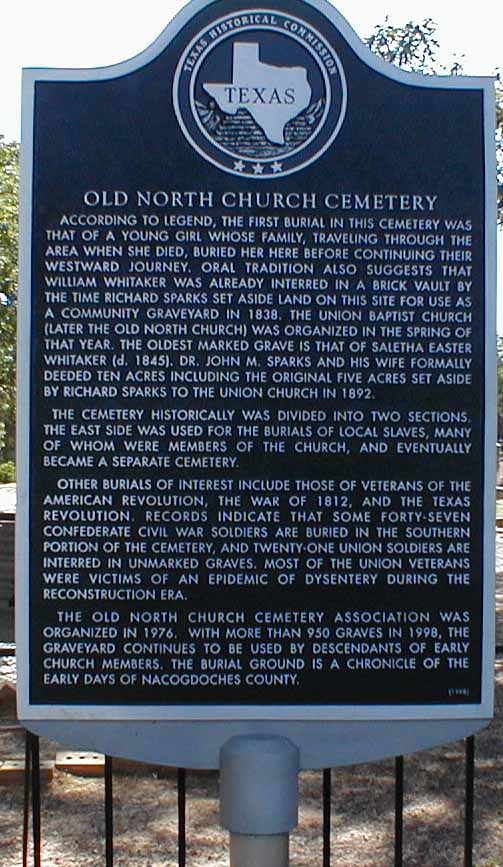
Old
North Church #1 and #2
est. 1836
alt. name: Union
#1 Caucasian Cemetery
#2 African-American Cemetery
|
From
Bus. 59 just north of Nacogdoches look for the "Old North
Church" sign and turn east on CR 205. The church and
cemetery are just a short ways down on the right
|
Photo
cemetery gate;
Photo
Historic Marker;
Cemetery
Map and Text of Historic Marker;
Church
and other photos;
Ericson's Nac. Co. Cem Books, Vol. II
|
|
Old
Philadelphia, see Salem
|
|
|
|
Old
Pine, see Pine Grove
|
|
|
|
Old
Pine Grove, see Pine Grove
|
|
|
|
Old
Shady Grove, see Mobley
|
|
|
|
Old
Smyrna, see Smyrna, Old
|
|
|
|
Old
Spanish
est. 1700s
|
Nacogdoches
County Courthouse Grounds - Corner of Main (TX 21) and North St.
(Bus. 59)
|
Historical
Marker Text;
|
|
Old
Stone, see Stone
|
|
|
|
Old
Stripling Place, see King - Davis King
|
|
|
|
Old
Union
est. 1854
|
From
Nacogdoches travel west on TX 21, turn south on CR 732 and
travel .3 miles; turn left on Alleluia Hills Ranch Road for .2
miles, cemetery on left
|
Our
transcript;
USGenWeb
Archives Project, contributed by
Ronald E. Gauntt, transcribed Nov 2001, corrections added June
2004;
Ericson's Nac. Co. Cem Books, Vol. IV
|
|
Our
Lady of Lourdes
est.1862
alt. name: Chireno Catholic
alt. name: Church of the Sacred Heart at Chireno
|
Across
from Our Lady Of Lourdes Catholic Church. West of Chireno off TX
21. From Nacogdoches travel 15.2 miles east on TX 21, turn north
(left) onto CR 353 and travel 1.5 miles. The cemetery will be on
the left and the church on the right (CR 353 is a bumpy dirt
road requiring slow speeds)
|
Gate
photos; Ericson's Nac. Co. Cem Books, Vol. I
|
|
Owens
est. 1882
alt. name: Owens #2
|
From
Nacogdoches travel north on US 259, turn west (left) on TX 204,
turn north (right) on CR 915, turn west (left) on CR 916,
cemetery on an old logging road between Holly Grove and Union
Springs
|
Ericson's
Nac. Co. Cem Books, Vol. III
|
|
Owens-Nelson
est. 1887
alt. name: Owens #1
alt. name: Nelson Family
alt. name: Oak Flat
|
N
314747 / W 0944702
From Nacogdoches travel north on US 259, turn west (left) on TX
204, travel about 7.2 miles, watch for cemetery sign (opposite
old Satterwhite house), go through gate in fence, cemetery is
north of road about 200 yards
|
Ericson's
Nac. Co. Cem Books, Vol. III
|
|
Pardin,
see Harden Family
|
|
|
|
Park
Street
est. 1879
alt. name: Zion Hill Baptist Church
|
Located
on the south side of Park Road just west of University Blvd. in
the city of Nacogdoches
|
Historical
marker photo and our transcript;
Zion Hill
Baptist Church History by The African American Heritage Project;
African American Heritage Project (AAHP) is a joint venture
between the Department of History, The Center for East Texas
Studies (CETS) at Stephen F. Austin State University, and the
Black Heritage Association of Nacogdoches.
|
|
Partin,
see Banks
|
|
|
|
Patterson
est. 1865
|
N
312021 / W 0942527
Private property in a pasture at Etoile, between highway 226 and
Sam Rayburn, off the dirt road near Blue Springs Cem
|
Transcript
of names;
Ericson's Nac. Co. Cem Books, Vol. V
|
|
Patton
est. 1877
alt. name: Oak Ridge
|
From
Nacogdoches travel east on TX 21 to Oak Ridge, turn south
(right) on FM 226, about 1/4 mile to cemetery on west (right)
|
Ericson's
Nac. Co. Cem Books, Vol. IV
|
|
Perry
|
Private
property, unknown location said to be on property near CR 890
and Beard Mountain south-west of Cushing
|
|
|
Pierce
Chapel, see Old Chapel
|
|
|
|
Pierce-Fuller,
see Old Chapel
|
|
|
|
Pilgrims
Rest
est. before 1873
|
N
313712 / W 0942402
From Nacogdoches travel east on TX 7 to Martinsville, turn south
(right) on FM 95, cemetery 1.5 to 2 miles down on east
|
Gate
photos; Ericson's Nac. Co. Cem Books, Vol. V
|
|
Pine
Flat
est. 1939
(African-American Cemetery)
|
From
Nacogdoches travel south on FM 1275, turn west (right) on FM
3228, turn east (left) on CR 527 to the cemetery
|
|
|
Pine
Grove #1
|
N
314619 / W 0944642
From Nacogdoches travel north on US 259, turn west (left) on TX
204 and travel 4.4 miles, turn south (left) on CR 836, turn
south (left) on CR 837, turn west (right) on CR 836, turn north
(right) on CR 855 which ends at the cemetery; OR
From Nacogdoches travel north on US 259, turn west (left) on TX
204, at Trawick onto the old Linn Flat-Douglass wagon road,
drive 2 miles, the road running north to Cushing dead ends at
that point, turn north, about a mile from the intersection the
Cushing road veers sharply off to the left, DO NOT TURN, drive
straight ahead on a little used graded dirt road and about 1/2
mile farther on it dead ends at the cemetery
|
USGenWeb Archives Project, contributed by Bobby Britnell,
Nov 2009; Ericson's Nac. Co. Cem Books, Vol. III
|
|
Pine
Grove #2
est. 1952
(African-American Cemetery)
|
From
Nacogdoches travel west on TX 7, turn south (left) on CR 613
|
Yesterdays,
2003 / 2004 / 2005 issues of the journal of Nacogdoches
Genealogical Society
|
|
Pine
Knot
est. 1874
|
N
312721 / W 0942602
From Nacogdoches travel east on TX 21, turn south (right) on TX
226 at Oak Ridge and travel through Woden, turn east (left) on
CR 422, 3-4 miles to cemetery (Old Prospect Church, located off
CR 422)
|
Ericson's Nac. Co. Cem Books, Vol. V
|
|
Pirtle
est. 1884
|
Private
property, From Nacogdoches travel north on US 259, turn west
(left) on TX 204, turn north on FM 2783. After 3.5 miles turn
north-west onto a local road that runs in front of the Happy
Valley Pentecostal Church. Follow the paved section of the local
road .6 miles to the cemetery
|
Gate
photos;
Ericson's Nac. Co. Cem Books, Vol. III
|
|
Pleasant
Hill #1
est. 1852
alt. name: Bogg
|
From
Nacogdoches travel north on US 259, turn east on FM 2664 to
intersection with FM 2864
|
Ericson's Nac. Co. Cem Books, Vol. V
|
|
Pleasant
Hill #2
est. 1980
|
From
Nacogdoches travel north on US 259, turn east on FM 2664 to
intersection with FM 2864, North of Pleasant Hill Missionary
Baptist Church
|
|
|
Polk
est. 1899
(African-American Cemetery)
|
Private
property off CR 817 north of Linn Flat
|
Our
transcript;
|
|
Post
Oak
est. before 1902
(African-American Cemetery)
|
N
313935 / W 0943701
From Nacogdoches travel north-east on FM 2609, turn west (left)
on CR 210, cemetery on east (right), affiliated with Harmonia
Church on Post Oak Road
|
|
|
Precella,
see Procella
|
|
|
|
Press,
see Christian
|
|
|
|
Procella
est. 1853
alt. name: Precella
alt. name: Fern Lake
|
N
312827 / W 0944337
From Nacogdoches travel south on US 59, turn west (right) on CR
659 (Old Lufkin Rd.), cemetery on west (right)
|
Our
transcript;
USGenWeb Archives Project, submitted by Ronald E. Gauntt,
transcribed 14 May 2002;
Ericson's Nac. Co. Cem Books, Vol. IV
|
|
Rape
est. 1862
|
Private
property east of FM 95 near CR 281 south of Garrison
|
Our
transcript;
|
|
Rawlinson
(single gravesite)
est. 1898
|
Private
property west of FM 1648 and south of Sacul
|
Single
grave of G. W. Rawlinson
|
|
Redland
est. by 1862
|
N
314334 / W 0945230
From Nacogdoches travel west on TX 21, turn north on FM 225 at
Douglass, turn west (left) on CR 870 for about 1 mile, cemetery
on north side
|
Ericson's
Nac. Co. Cem Books, Vol. III
|
|
Rhodes
est. 1910
(African-American Cemetery)
|
Private
property near CR 256 south-east of Appleby
|
|
|
Ritnour
(single gravesite)
est. 1883
|
Private
property near CR 829 north of Lake Nacogdoches (east of Douglass)
|
Single
grave of Cora Anna Ritnour
|
|
River
Fork, see Smyrna
|
|
|
|
Roberts
est. 1909
|
Private
property near CR 489 at southern tip of the county
|
|
|
Rock
Springs
est. 1848 or 1855
|
From
Nacogdoches travel north on US 259 to Central Heights, turn west
(left) on FM 698 and travel about 4 miles, turn north on CR 819
to Rock Springs Presbyterian Church
|
Our
transcript;
Ericson's Nac. Co. Cem Books, Vol. III
|
|
Rocky
Mount
est. 1861
alt. name: Rocky Mound
alt. name: Rocky Mountain
|
From
Nacogdoches travel east on TX 21, about 3.75 miles past Loop 224
turn south on FM 226, travel 11.8 miles to TX 103, turn east
(left) about 2 miles, cemetery on north side
|
Ericson's
Nac. Co. Cem Books, Vol. IV
|
|
Rusk
est. 1840
African-American Cemetery
|
From
Nacogdoches travel west on FM 225, turn north (right) on CR 715,
turn east (right) on CR 712 (Rusk Cem. Rd.) to cemetery near
Mangham Airport
|
|
|
Russell
est. 1860
|
unknown
location said to be near Nat community
|
Ericson's
Nac. Co. Cem Books, Vol. III
|
|
Sacred
Heart, see Our Lady of Lourdes
|
|
|
|
Sacul
est. 1849
alt. name: Williamson-Hughes-King
|
From
Nacogdoches travel north on US 259, turn west (left) on TX 204
to Sacul turn south (left) on CR 896 (Cemetery Rd.) just before
entering Sacul
|
USGenWeb
Archives
Project, contributed by
Phyllis Ann Gresham
McBride,
Oct 2001;
Ericson's Nac. Co. Cem Books, Vol. IV
|
|
Saints
Rest
est. before 1868
|
From
Nacogdoches travel south on FM 1275m turn west (right) on CR
538, about 1 mile to cemetery
Homecoming - First Sunday of October
|
Our
transcript;
USGenWeb
Archives
Project
A-C,
D-G,
H-P,
R-T, contributed by Laura Flebbe Feb 2000;
Ericson's Nac. Co. Cem Books, Vol. IV
|
|
Salem
est. 1939
alt. name: New Salem
alt. name: Old Philadelphia
alt. name: Salem Methodist
|
From
Nacogdoches travel north on Bus. 59, turn west on FM 343 about
10 miles to CR 841, cemetery on north side
|
|
|
Sanders-Bruton
est. 1857
alt. name: Bruten
alt. name: Bruton
(African-American Cem.)
|
Private
property north of Lake Nacogdoches
|
Our
partial transcript;
Ericson's Nac. Co. Cem Books, Vol. IV
|
|
Sand
Hill
est. 1882
(African-American Cemetery)
|
From
Nacogdoches travel east on TX 21, turn north (left) on CR 338,
Sand Hill Baptist Church and cemetery on east side
|
|
|
Sand
Ridge
est. 1848
(African-American Cemetery)
|
Next
to Sand Ridge Baptist Church
|
|
|
Scott
|
unknown
location on private property
|
|
|
Shady
Grove
est. 1891
|
From
Nacogdoches travel east on TX 7, turn north (left) on FM 2112,
just past FM 2713 the cemetery will be on the west (left)
|
Transcript
of names;
Ericson's Nac. Co. Cem Books, Vol. V
|
|
Simpson
Family
est. 1855
Possible burial place of Simpson slaves also
|
Private
property west of FM 226 and south of Oak Ridge
|
|
|
Simpson's
Campground
est. 1830s or 1893
|
From
Nacogdoches travel south on FM 2259 for 8.0 miles, turn north
(left) on FM 226 for 0.2 mile, turn right onto County Road 410
for 0.3 mile to cemetery
|
Our
transcript;
USGenWeb Archives Project, submitted by Allen R. Perkins,
May 2002;
Ericson's Nac. Co. Cem Books, Vol. IV
|
|
Skillern
Family #1
est. before 1850
|
Located
south east of Nacogdoches. From Nacogdoches travel east on TX 21
about 13.5 miles, turn south (right) on CR 434 and travel 1.5
miles., turn west (right) onto CR 430 and travel 1.2 miles over
dirt roads to the cemetery; at one point the road will split and
you should take the right fork (at times the CR signs are
missing, a county map can help locate the cemetery without the
signs; maps are available from County Judge, County Courthouse
at intersection of North St. (Bus. 59) and Main St. (TX 7/TX 21)
|
Transcription;
Ericson's Nac. Co. Cem Books, Vol. I
|
|
Skillern
#2
est. before 1850
|
Located
near Skillern Family Cem. #1
|
All
markers have been lost
|
|
Smyrna,
New
est. 1862
alt. name: Smyrna
alt. name: Jackson
alt. name: Chinita
alt. name: River Fork
|
N
311850 / W 0942136
From Nacogdoches travel east on TX 21, about 3.75 miles past
Loop 224 turn south on FM 226, travel 11.8 miles to TX 103 where
must jog left and then right again to stay on FM 226; from TX
103 travel south, turn east (left) on CR 489, turn south (right)
on CR 490 past Old Smyrna to next intersection with CR 496,
cemetery on a hill at intersection In front of the Tabernacle,
from Etoile and highway 103 travel 5.3 miles south on FM 226,
left on CR 489 for 2.5 miles
|
Our
transcript and photos;
USGenWeb Archives Project, contributed by Debra and Bob
Hardin, transcribed 22 May 2004;
Ericson's Nac. Co. Cem Books, Vol. IV
|
|
Smyrna,
Old
est. 1867
alt. name: Stripling
alt. name: Baptist
alt. name: Love
|
From
Nacogdoches travel east on TX 21, about 3.75 miles past Loop 224
turn south on FM 226, travel 11.8 miles to TX 103 where must jog
left and then right again to stay on FM 226; from TX 103 travel
south, turn east (left) on CR 489, turn south (right) on CR 490
(Smyrna Cem. Road), cemetery on right
|
Our
transcript and photos;
USGenWeb Archives Project, contributed by Debra and Bob
Hardin, transcribed 22 May 2004;
Ericson's Nac. Co. Cem Books, Vol. IV
|
|
St.
Paul's
est. 1892
African-American Cemetery
|
In
south-east Nacogdoches, south of TX 21 (Main St.) and east of FM
2259, affiliated with St. Paul's C.M.E. Church
|
Our
transcript;
|
|
Stallings
Place
est. 1897
|
unknown
location
|
|
|
Stone
est. 1842
alt. name: Old Stone
|
N
313756 / W 0944437
From Nacogdoches travel west on TX 21, cemetery is just past CR
732 on south side
|
Our
transcript;
USGenWeb Archives Project, contributed by Richard Stone, Aug
2002;
Ericson's Nac. Co. Cem Books, Vol. IV
|
|
Stonewall
est. before 1882
alt. name: Upshaw
(African-American Cemetery)
|
From
Nacogdoches travel west on TX 21 through Douglass, turn north
(right) on CR 3, turn west (left) after about 4/10 mile on a
path to cemetery behind a pasture
|
|
|
Strickland
est. 1857
alt. name: Strickland-Hart
|
N
314754 / W 0943254
From Nacogdoches travel north on US 59, turn west (left) on CR
164, turn west on CR 169, about 1 mile past church is cemetery
on north (right)
|
Transcript
of names;
Ericson's Nac. Co. Cem Books, Vol. V
|
|
Strickland-Hart,
see Strickland and see Hart
|
|
|
|
Stripling,
see Smyrna, Old
|
|
|
|
Sunset
Memorial Park
est. 1946
|
N
313919 / W 0943926
Located on west side of on US 59 1/10th mile north of
intersection of Stallings Dr. and US 59
|
Ericson's
Nac. Co. Cem Books, Vol. II
|
|
Swift
est. 1857
|
From
Nacogdoches travel east on TX 7 about 8 miles to FM 2713 / CR
331, cemetery is east of Hopewell Baptist Church on south side
of TX 7
|
Our
photos and transcript;
USGenWeb
Archives
Project, Submitted by Billie & Dick Wingate, Aug 2001;
Ericson's Nac. Co. Cem Books, Vol. I
|
|
Thomason
est. 1877
alt. name: Thompson
|
Private
property near CR 330 between Swift and Melrose (get a guide)
|
Our
transcript;
USGenWeb
Archives Project, Submitted by Billie & Dick Wingate, Aug
2001;
Ericson's Nac. Co. Cem Books, Vol. V
|
|
Tolbert
African-American Cemetery
|
Destroyed
long ago - said to have been off Woden Rd. between Woden Rd. and
TX 21
|
|
|
Trawick,
see Barnes
|
|
|
|
Turnipseed
#1
est. 1910
(African-American Cemetery)
|
Private
property near CR 841 north of Lake Nacogdoches
|
Our
partial transcript;
|
|
Turnipseed
#2
est. 1851
(African-American Cemetery)
|
Private
property near CR 825 west of Nacogdoches and north of TX 21
|
|
|
Union,
see Old North Church #1 and #2
|
|
|
|
Union
Springs
est. 1900
|
From
Nacogdoches travel north on US 259 about 15 miles, church and
cemetery on the left, between Central Heights and Mount
Enterprise
|
Our
transcript;
Linked
transcript (not indexed in our search tool);
USGenWeb
Archives Project, Submitted by Billie & Dick Wingate,
transcribed July 2001;
Ericson's Nac. Co. Cem Books, Vol. III
|
|
Unnamed
Cemetery #1
(African-American Cemetery)
|
unknown
exact location near CR 496 in southern tip of the county
|
|
|
Unnamed
Cemetery #2
|
unknown
location south of Appleby
|
|
|
Unnamed
Cemetery #3
|
Several
small family cemeteries in the dense woods near Clifton Cemetery
(east of US 259 near CR 144 in northern area of the county
|
|
|
Upper
Chireno, see Chireno, Upper
|
|
|
|
Upshaw,
see Stonewall
|
|
|
|
Walls
Chapel, see Cornelius
|
|
|
|
Walnut
Grove
est. before 1858
|
From
Nacogdoches travel north on US 59 to Garrison, turn west (left)
on FM 1087 (FM 95), turn south (left) on CR 173 (Mount Union
Church), cemetery .5 miles on left
|
Linked
transcript (not indexed in our search tool);
USGenWeb Archives
Project, contributed by
Ray Jackson,
Jan 2000;
Ericson's Nac. Co. Cem Books, Vol. V
|
|
Ward
est. 1920
(African-American Cemetery)
|
From
Nacogdoches travel north on Bus. 59, turn west (left) on FM 343,
turn south (left) on FM 225, turn west (right) on FM 343, turn
north (right) on FM 1648 to Lucas Lake, turn west (left) on CR
898 almost to county line, cemetery on south (left)
|
|
|
Watkins,
see Whitaker
|
|
|
|
Watson
est. before 1880
(African-American Cemetery)
|
N
313532 / W 0944910
From Nacogdoches travel west on FM 225, turn north (right) on CR
753, straight ahead on CR 755 (Watson Cem. Rd.) to cemetery
|
|
|
Whitaker
est. 1869
alt. name: King #2
alt. name: Watkins
alt. name: Wisener
|
Private
property south of TX 21 near FM 3, near Finley Cemetery
|
Ericson's
Nac. Co. Cem Books, Vol. III
|
|
White,
see Blackjack #2
|
|
|
|
Wilburn,
see Mahl #1
|
|
|
|
Williams
Tomb
|
unknown
location but referred to in interviews of Pulley
|
|
|
Williamson-Hughes-King,
see Sacul
|
|
|
|
Wilson
Chapel, see Center Point
|
|
|
|
Wisener,
see Whitaker
|
|
|
|
Wisner,
see Rusk
|
|
|
|
Wooten
est. 1899
|
N
311917 / W 0942253
From Nacogdoches travel east on TX 21, about 3.75 miles past
Loop 224 turn south on FM 226, travel 11.8 miles to TX 103 where
must jog left and then right again to stay on FM 226; from TX
103 travel south, turn east (left) on CR 489, cemetery on east
side
|
Our
transcript and photos;
USGenWeb Archives
Project, contributed by Debra and Bob Hardin, May 2004;
Ericson's Nac. Co. Cem Books, Vol. IV
|
|
Y'Barbo,
see Mountain
|
|
|
|
Zion
Hill Baptist Church, see Park Street
|
Zion
Hill Baptist Church Cemetery
Park Street, Nacogdoches, Texas.
|
Historical Marker and Photo;
Linked
transcript (not indexed in our search tool);
USGenWeb Archives Project, contributed by Eric B., Feb 2003;
|
|
|
|


