 Fannin
County TXGenWeb Fannin
County TXGenWeb
Towns &
Communities
THE COUNTY
SEAT IS BONHAM
First named
Bois d'Arc then for a short time referred to as Bloomington
Map
of Bonham
Go
Here For List of Post Office and Post Masters
Schools
Sandborn
Fire Insurance Maps are online for :Bonham , Ladonia, Leonard ,Wolfe
City, Whitewright; Each available for different years. Very informative!
If you have trouble
getting in, try a second time & if still having trouble - go to their
main page and keep trying. Don't fill out the form -- just keep trying
to enter.
These
Maps give the location of every building down to the outhouses and what
they look like, shape,size and type of siding and roof. You can view the
whole town a block at a time.
and;
The Sandborn
Fire Maps are available free online to any Texas Resident through
the "Texshare databases" program offered by all public libraries in Texas.
Ask your librarian for the password and URL of the Texshare, you also will
get Heritage Quest with it's free census images, Rev. war penison files,
Freedman's Bureau and thousands of online family tree books.
Information
on Rivers, Lakes, Creeks, & Ferry's

TXGenWeb's
Texas Landmarks Pages & Fannin
County
Place Names with
links to maps and pages etc.
-Topographical Maps are
marked with 
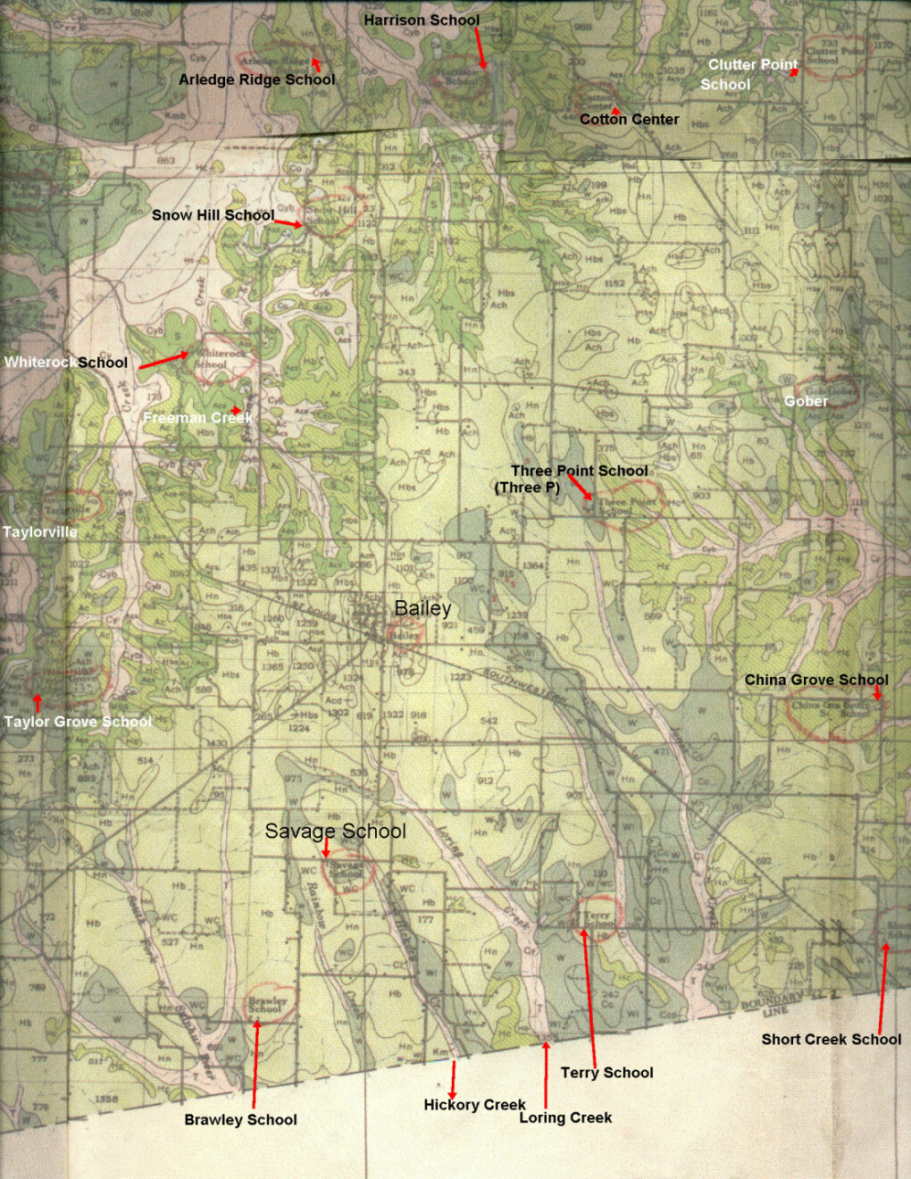
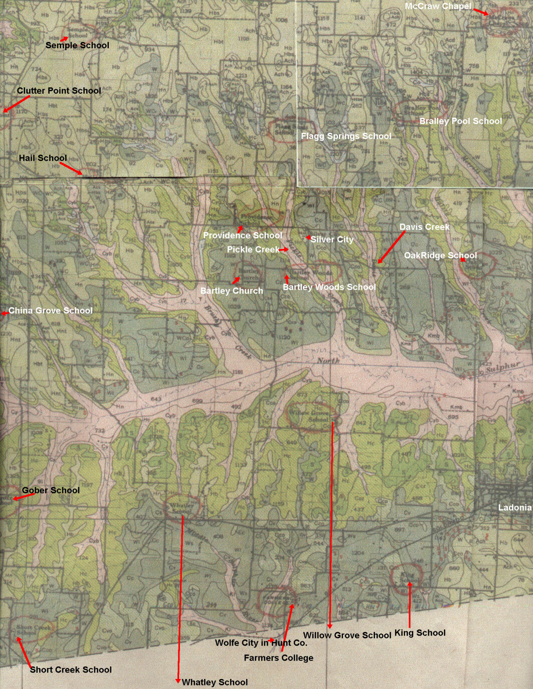
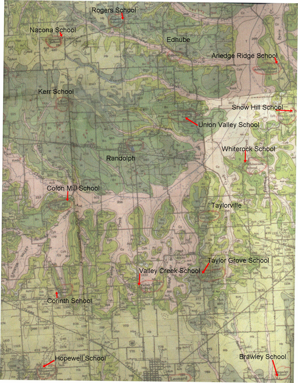
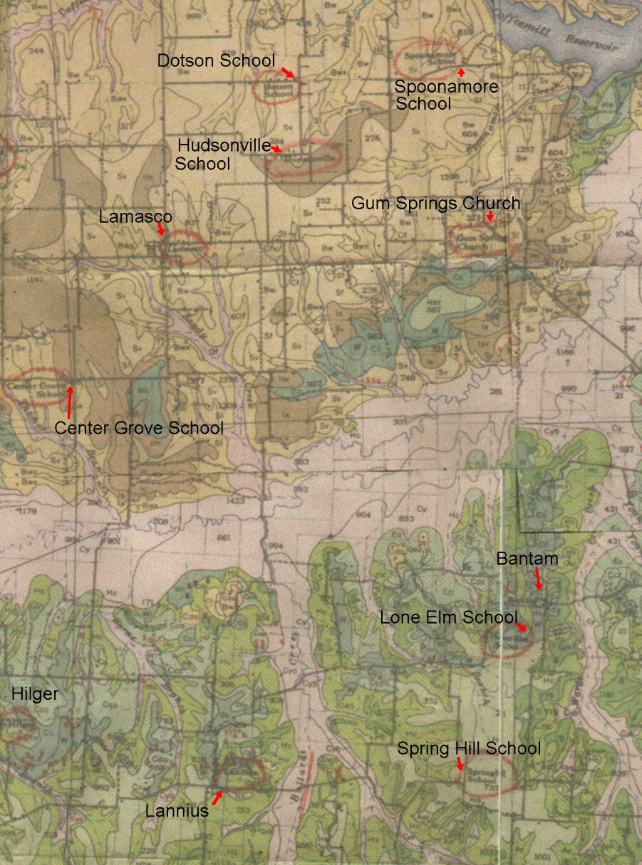
This map was
provided by Billy Suitor who has the original. The scans were pieced together.
This was published first in 1927, by the Texas State Agricultural System
.This copy is from the 1939 reprint of the 1927 edition. I have added the
arrows as not all the names were easy to read in the scans. The red Circles
were already on the original copy. The black dots are are buildings along
the road.It is invaluable as to the exact location of schools and homes.
Save the images on your computer and then enlarge if you cannot see the
details . I can also send an unmarked map of an area if you are able to
receive large images in the email.
-
Adams
School
-
Allen's
Chapel ,Nicholson
Post Office Map
-
Allen's
Point ,Yew was the name of thePost
Office there.Map
-
Alpha Comm. 6 1/2 miles SW
of Bonham , post
office
-
Anthony
north
of Savoy , at hwy 1753 & 1752 , Map
, Post Office
-
Arkada Post
Office location 7 mi. SE of Dodd City near Wood's Prairie
-
Arledge
Ridge School &
Map
-
Asa, between Leonard &
Valley Creek had a Post
Office
-
Ash
Grove School & Community Area
& Map
& Map
2
-
Auvanti 7 mi. SE of
Ladonia part in Hunt Co., Post
Office
-
Bagby
NE
of Ladonia 4 mi .Post
Office Location Map
-
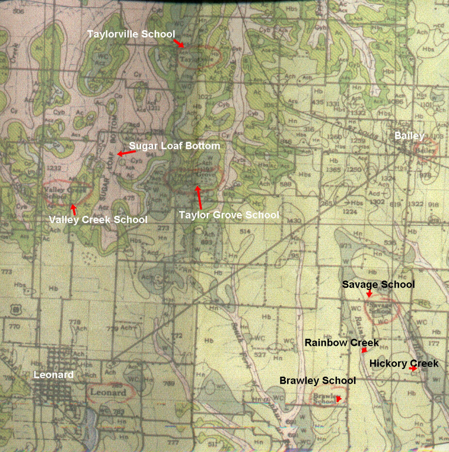
Bailey
Map
of Bailey Area hwy 11 & 78 NE of Leonard Post
Office Map
& Map 2
-
Bantam
N. of Windom 5 mi. Post
Office
-
Bartley
Woods & Bartley Woods School located near Arkada at
Woods Prairie; Map
-
Bear
Creek
-
Bentonville see Edhube
-
Bettis
School
-
Bettis
Creek
-
Bettes (Bettis ) Community
-
Bigbee
School &
Map , also a Cemetery located SE of Telephone sometimes
misspelled Bigsby on maps. Store there called Perkinsville.
-
Blackberry Plains early name
of Savoy had a Post
Office
-
Blanton's Chapel west of
Leonard
-
Black
Branch Creek
-
Blanton
Creek
-
Blunt just East of Bailey
had a Post Office
-
Bois d'Arc first name of
Bonham on Post
Office List
-
Bois d'Arc Creek - This is
the main water course in Fannin County , starting SW goes diagonally across
the county to the NE corner.
-
Bois d'Arc School seeMap
&
Map
-
Boyd
School &
Map 2
-
Bralley
Pool School - Bralley
Pool Cemetery
-
Brawley
School
-
Brotherton
School- Map
2; west of Dodd City on hwy 56
-
Bryant
Bluff
-
Bugtussle
on Merrill Creek N. of Ladonia hwy 50 & 1550 Map (Photos)
-
Burnett
School &
Burnett Community
-
Caney Creek Post
Office near Savoy, Also called Coontown
,Map
-
Caney
Slough
-
Carson
E.of Lamasco , aka Gum Springs, Map-
Post
Office
-
Center
Grove School ( Center Point is the same)
-
China
Grove School & Map
2
-
Clutter
Point
S. of Bonham & W. of Gober
-
Coffee
Mill Creek & Res.
-
Colon
Mill School
( IS this Cotton Mill?)
Map 2
-
Corinth
School
-
Cottage
Bend School
-
Cotton
Center hwy 271 5 mi. SE of Bonham Map
-
Cottonwood
School
-
Cottonwood Creek
-
Covey
Community where the Covey Schoolhouse was
-
Crutchfield N.of Hilger Cemetery
Post
Office
-
Danner
School & Post
Office CR2610 NE Lake Bonham
-
Davis
Creek
-
Delba
5
Mi. W. of Leonard .
map hwy 78. A Tornado destroyed it in 1919 Post
Office - History
of Delba
-
Delba
Creek
-
Davy
Crockett Res.
-
Dial
hwy
824 almost on county line, Map
shows
the school, NE of Ladonia.
Post Office
-
Dodd
City
7 mi. E. of Bonham on hwy 56 Map
.Called just Dodd at first ,Post
Office
-
Dog
Town - North West of Ladonia
-
Doniphan East side of Bonham
Lake Post Office
-
Dotson
School &
Community
N. of Hudsonville
-
Duplex
hwy
273 near Lake Fannin ,N of Ivanhoe , Post
Office ,Map
-
Ector
6 mi. west of Bonham on hwy 56 Map
of Ector Area Map
2 ,Victor was the first name of Ector Post
Office
-
Edhube
on
hwy 121 first called Bentonville.Location of Hampton School Map
& Map 2
S of Bonham Post
Office
-
Elizabeth's Grove, located
where the Valley Creek Lake is today north of Savoy-site of the 'Sinner's
Den School'
-
Elwood
20
mi. N. of Dodd City , Map
on the Red River.Post
Office
-
Ely (Map
) on Hwy 898 NE of Whitewright , Post
Office
-
English
School
-
Enterprise
School, Church & Community W of Ely on hwy 898
-
Fariview
School & Church W. of Ravenna is sometimes called the Price
Community
-
Farmers'
College
-
Finley
School
near Sowell's Bluff
-
Flagg
Springs School
-
Flag Springs where the Wall Cemetery is today
-
Flat Prairie Community
see North Sulphur
-
Fort
Lyday near Dial on the Sulphur River near County line to Delta County
-
Fort Warren see Warren
-
Foster
Valley
-
Frank
Nw
of Bailey on cr1553 Post
Office , Called Taylorville Also.
-
Free
Hart Prairie - Map
-
Freeman Creek
-
Fulp north of Ector( named
for Russell Fulp )Fulp School there, see New Fulp Post
Office
-
Garnett's Bluff Post
Office
-
Gentry
School - Nobility
(The community was Nobility)
-
Gober
first
called Grittersville
Map 1, Map2
,hwy 271 SE of Bonham,Post
Office
-
Gossville
location of the Goss Plantation, a large plantation with a lot of employee's
who lived on site and it had a school and store.
-
Green's
Chapel, N of Honey Grove near Bois d'Arc Creek &Map
-
Grove
Hill ---------Oakhill
Post Office
-
Gum
Springs Church - Location of the Carson Community ( not location
of the Carson Cemetery)
-
Hail
S of Dodd City 5 mi on hwy 2077 Map
aka
Biggerstaff Post
Office
-
Harrison
School & Map
-
Hawkin's
Prairie on Coffee Mill
Creek at Ivanhoe today Post
Office
-
Haynes Community located
at hwy 898 & 1396 SW of Ivanhoe
-
Hickory
Creek Map
of the creeks start in Fannin Co., in Hunt County it had
a Fannin County Post
Office then transferred. There is a Hickory
Grove just over in Lamar County
-
High
Prairie & Map
& Map
-
Hilger
Community on Onstott Creek E of Bonham , Post
Office
-
Hogg Community just east
of Bailey on 1552 Post
Office
-
Hopewell
School
-
Honey
Grove hwy 82 E side of the county- Post
Office
-
Houghton Community NW of
Bailey Post
Office
-
Hudsonville
Map,
Just NE of Lamasco was the home of the the county farm/home and an orphanage,
Post
Office
-
Indian
Creek
-
Ivanhoe
-
Map ; earlier called Hawkins' Prairie. NNW of Bonham.
S. of Tulip Post
Office
-
Johnson
School
-
Jones
Mill Community
-
Kerr
School
-
King
School
-
Ladonia
S.
Of Honey Grove on County Line 1927
Topographical Map
-
Lamasco
W of Carson Map
-
Lannius
N.of Dodd City - Map
-
Lee
Creek ( on and near the Bob Lee Cemetery area. Dan'l Lee's Farm)
-
Leonard
-Map - Map
1- Map2
-
Post
Office
-
Liberty
School
-
Licke (till1857) & Lick
(till 1871) Post
Office near Dodd City
-
Lindsey SW of Bonham
, just N of todays Randolph
-
Lindsey
Creek (Lindsey Springs)-south and east of Whitewright
-
Lone
Elm (pronounced EL- UM) School & Map
-
Longbranch location
of the Longbranch school near Fulp
-
Lyday's Crossing Community
-
Macon's Chapel ( Church of
Christ), 3 miles northeast of Leonard.
-
Mahurin
School
-
Marvin's Chapel
hwy 898 W of Ely
-
Mayfield
School and Community -N. of Telephone on the River Road
-
McCraw's
Chapel & Map
-
McRae Community
6 mi. NE of Ivanhoe Post
Office
-
Medlintown W of Trenton on
Chinquapin Creek (
Near the Richland School shown on this map)
-
Michigan
Prairie & the Michigan
School
-
Monkstown
( named for James Monk)- Topographical
Map , Post
Office
-
Mooreland West of Leonard
-
Moore's
Chapel
S. of Bonham StatePark ( named for Absolom Moore)Map
& Map 2
-
Muddig
Community - Muddig
School (also called Pecan School)-near Ladonia
-
Mulberry
5 mi NW of Ravenna in the far NW corner of FanninCo, Map1 -Map-
first called Rosedale - Post
Office
-
Murphy
Creek
-
Nacona
School
-
Nailor
7 mi. NW of Ladonia Post
Office
-
Narvough
(Narvoo)
Creek at Elwood
-
New
Fulp location of the consolidated schools of Fulp & Longbranch,
Map
-Carson Cemetery there today
-
New
Hope Church and School & Map
-
New
Warren School
-
Newt
on hwy 79 just west of Riverby, location of the Goss
Farm
--,Post Office
-
Nicholson see Allen's Chapel
6 Mi. NW Honey Grove
-
Nobility
7 mi W of Leonard almost to Grayson Co. Line hwy 78 MAP
first Called Gentry, Post
Office
-
North Sulpher (Flat
Prairie) Ladonia - Post
Office
-
Novoco N. of Honey
Grove ,Post Office
-
Nunnelee
School NW of Bonham Map
2 (Map
3 showing Nunnelee)
-
OakHill - Grove Hill's Post
Office name, name of Confederate unit here
-
Oakland
Also
see a class picture exact date unknown
-
Oakridge
S.
of McCraw's Chapel N. of Ladonia - Map
-
Orangeville
E. of Whitewright, Post
Office map
-
Parker Grove School Map
-
Pecan
Grove Church
-
Pecan Gap just over the County
Line E. of Ladonia, in Delta County
-
Perkinsville, name of a general
store located near the Bigbee School & Cemetery. Named by Mr. Perkins,
owner.
-
Pickle
Creek
-
Pike is just over the line
into Collin County SW from Leonard
-
Pilgrim's Rest S. of Telephone
off hwy 2275
-
Pleasant Grove Community
-
Popes' Point
-
Porters School, Chapel , Cemetery and Community
-
Portland
5
mi SW of Gober Post
Office
-
Post
Oak School
-
Post Oak Community W. of
Hudsonville
-
Prairie Hill ( aka Prairie
Point)SW of Dodd City, 4 1/2miles
-
Price Community see
Fairview
-
Prosper N. of Dodd City 4miles
-
Providence
School
-
Ragsdale
This early settlement was located NW of Monkstown ,W of Riverby Map
;
The Richardson
Cemetery is located there today.
Post
Office
-
Rainey (Raney)N. Of Ladonia
Post
Office
-
Ranchetto NNW of Bonham Post
Office
-
Randolph
- Map
- Post
Office
-
Ravenna
named
for Ravines in the area, Map
-Map - Post
Office
-
Rehobeth SW of
Ladonia
-
Reuben (Ruben) 7 Mi. SW of
Honey Grove Post
Office
-
Richlandville , (
Richland School ) WNW of Trenton Post
Office
-
Ridings
School
N. of Bonham , 12 miles ,Post
Office
-
Riverby&
Riverby School ,above Monkstown , Topographical
Map
-
Rockpoint School and Community
-
Rogers Community SW of Bonham,
Rogers Comm. named for family but Dover school (changed to Rogers School
)Was there.Map
-
Rogers
Cemetery there today
-
Root 7 mi. SE Dodd City Post
Office
-
Rosedale - see Mulberry
Post
Office
-
Quinsey
same as Dodd City
-
Sandy
Creek
-
Sash
N. of Honey Grove 15 mi - Post
Office
-
Savage
3mi. S. Bailey - Post
Office - Map
-
Savoy
earlier called Blackberry Plain - Map2
-
Post
Office
-
Selfs
N. of Allen's Point - Map
2 - Post
Office
-
Semple
School
-
Shaw West of Leonard
three miles Post
Office
-
Shilo- Located SW of Bonham,
the only thing left is the Shilo
Cemetery
-
Shiloh
Community where life centered around the school-
MAP -Located North of Honey Grove
-
Siloam
Church , later moved about a mile west and merged with the Belfountain
Church that moved from south - They formed Union Church ( Union
Cemetery nearby)
-
Short
Creek School
-
Silver
City E. of Gober 5 mil. ( &
this information) & Map
-
Slade S. of Gober 5 mi.
-
Snow
Hill School & Map
2
-
Sowell's
Bluff
on the Red River N. of Ravenna Post
Office named for Joseph Sowell
who was killed in 1841 and buried on the bluff. also there :Sowells' Bluff
Bridge .
-
Spoonamore
Creek School , a cemetery is nearby
-
Spies Lake , located on the
Spies 'Plantation' .Large Cotton Plantation
-
Spring
Hill School
-
Sugar
Loaf Bottom
-
Taylor
Grove School
-
Taylorville
Called Frank earlier NW of Bailey (first named Taylorville for Francis
"Frank Taylor"and later 'Frank'.Map
-
Telephone
- Post Office
named after total rejection of all other submitted names, the only telephone
in the area was there and the name selected. Telephone Cemetery, and Forest
Grove Cemetery there . Map
of Telephone
-
Terry
School (near Rehobeth Church)
-
Three-P
Name given to the school for Philidelphia, Portland, and Prairie Hill when
consolidated. Was called Three
Point orginally.
-
Timber Creek Community N.
of Bonham on the Creek, Where Brown
Cemetery is today, Site of Brown Church and school, first named for
the Timber Creek Union Church and later changed to Brown's Church
-
Titus
School
-
Trenton
SW
Corner of Fannin County
-
Truss
Community & School N. of Ladonia , Post
Office named for John I. Truss
-
Tulip
on the Red River - first called Lexington first
Court of the county held here Map
- Post Office
-
Union Hill SW of Randolph
-
Union
Valley School often called Swipeout name from theft of buggy
whips., location of the Union Church.
-
Valley
Creek & Valley
Creek School
see Map showing school, Post
Office at Valley Creek
-
Victor see Ector
-
Vinyard Grove near Allen's
Chapel
-
Virginia
Point School & Church , near Warren's Post NW corner of Fannin
Co.
-
Ward Creek Topographical
Map
-
Warren
,Warren's Post aka Old Warren in the far NW corner of FanninCounty
-
Whatley
School
-
Whiterock
named for the land NW of BaileyMap
& Map 2
-
Whitewright
Partially
in Fannin County & Grayson County on the West Central countyline
-
Willow Grove School
-
Willow
Wild Cemetery in Bonham
-
Windom
E.
Of Dodd City Map
: Map 2.
-
Woods
Community _( school later became Bartley - Woods School)
-
YEW Post office name for
Allen's Chapel
© 2006
Email
Any Additions or suggestions
Fannin Home page


|