Dickens County Historical Markers
The markers encountered in Dickens County are designated Official Texas Historical Markers received from The Texas Historical Commission. Markers are erected to commemorate historical sites, buildings and events; institutions such as churches, businesses, and organizations; and individuals whose achievements have been recognized.
The most common types of markers are the aluminum with raised lettering on a black background. Some of the earlier markers may be made of stone, usually granite, featuring either engraved lettering or a metal plate with inscription. Another marker is the round medallion, which identifies a structure as a Recorded Texas Historic Landmark. An interpretive plate offering historical background of the building often accompanies the medallion.
The inscriptions on the roadside markers are written by the historians of the county, based upon research done by contributors to the Dickens County Historical Commission.
On April 1, 1893, the Commissioners voted to receive the new courthouse, "having examined the building in a body and the same having been built according to the plans and specifications heretofore adopted."
The court reserved out of the contract price the sum of $2,500.00 to cover any deficiency in the work as rewhiting the walls, completing the painting, putting in glass and removing rubbish.
The Dickens County Courthouse was built in the traditional quadrilateral form with a cruciform plan of intersecting halls defining county offices on the ground floor, and the county courtroom dominating the second floor. During construction contractor E. L. Aikens petitioned the Commissioners´ Court and received permission to build the stairway on the north end of the hallway instead of the south end of the hall as shown on the plans.
Built of a light-colored stone from a quarry two miles northwest of town, the building originally featured a polygonal central tower with a domed cupola. The four elevations were of simple rock-faced masonry with square windows and arched entries. The main entry on the west side was marked by a double arch and a recessed pedimented pavilion. At the north and south facades projecting ornamental balconies sheltered the entrance. On either side of the entrance a pair of chimneys rose above the roof line. A molded cornice and hip-roofed pavilion with round finials
surmounted the whole.
On November 9, 1936, a contract was let to Nugent Construction Company of Spur to remodel the courthouse for the sum of $15,000.00. About 20 feet were added on the east side. A basement was incorporated into the addition for storage of county records. The central tower was removed and new doors and windows were added. The building was painted inside and out. A new heating system was added replacing the original wood and coal stoves.
On February 20, 1960, a contract was let to the West Texas Utilities Company of Abilene, to add a central heating and cooling system. Storm doors and windows were also installed. The remodeling cost a total of $10,139.34. In July 1962, a new vault was added to the county clerk's office at a cost of $9,720.00.
The central tower and roof elements were removed and replaced with a flat roof and featureless cornice. Recently the paint has been removed from the exterior walls.
In November 1892, the Commissioners' Court authorized the sale of bonds to finance a new jail. Subsequently the structure was completed by contractor E. L. Aiken. However, the jail did not meet specification and the court refused to accept it.
Over a decade passed before work was authorized for another detention facility. In 1909 the Southern Steel Company of San Antonio was contracted to build the present jail.
The Dickens County Jail is a two-story stone structure located northeast of the courthouse. It displays architectural detailing similar to the courthouse. The rusticated stonework symbolized the jail´s permanence and security. Facing south, the front facade features an arched main entrance with heavy stone voussoirs. The remaining openings on all elevations are tall rectangular windows capped with large stone lintels. The structure is still used as the county jail.
In the sparsely populated counties of West Texas, the courthouse building was often the
dominant architectural feature on the landscape. As such, it became a prime influence on town layout and a focus of social and governmental activities. The Dickens County Courthouse is a typical example of the process and one of the earliest significant buildings in Dickens County. As an integral part of the historic development of the area, it is, therefore, worthy of preservation. It is among the few substantial nineteenth-century masonry buildings still standing in West Texas.
Dickens County was created in 1876 and named for J. Dickens, defender of the Alamo. After the organization of the county, the Commissioners' Court met in Dockhum on April 1, 1891, and selected Espuela as the temporary county seat. Located 8 miles below the escarpment of the Llano Estacado, the townsite served as a supply point for an area where the first permanent settlements were dugouts serving as line camps for the Spur, Matador and Pitchfork Ranches. A store owned by W. R. Stafford was rented by the county for $15.00 a month and served as the county courthouse until the construction of a permanent building in 1893.
When the town was laid out a centrally located public square was set aside as the site of the courthouse. Commercial lots faced this public space on all four sides. By 1893 the new courthouse, a hotel, two stores and a wagon yard comprised the town.
Throughout its history the courthouse has been a center for social activity in the town of Dickens. During the early years of its occupation, it was the setting for justice and business transactions in the county. It also served as a meeting place for various groups of people. Today it continues as a center of county activity and houses, in addition to its official functions, a museum. In the buildings around the square are such functions as attorneys' offices and senior citizens´ activities.
The Dickens County Courthouse was awarded the Texas State Historical Survey Committee's State Medallion in December 1962 for its 70 years of service.
The Dickens County Jail represents one of the oldest structures in the small West Texas town of Dickens and has served as the county jail since its completion.
BIBLIOGRAPHY ON FILE IN THE NATIONAL REGISTER
Marker Title: DICKENS COUNTY COURTHOUSE
Current Use: Active Courthouse
Index Entry: Dickens County Courthouse
City: Dickens
County: Dickens
Year Marker Erected: 1962
Marker Location: Courthouse Square, Hwy. 82, Dickens (marker is inside of courthouse)
UTM Easting: 329550
UTM Northing: 3721650
Marker Size: Medallion Only
Owner: County
Service Dates: 1893-present
Construction Date: 1893
Architect: E. L. Aiken
Contractor: E. L. Aiken
Style: Romanesque Revival
Square Footage:
RTHL Date: 1962
SAL Date: 1992
National Reg. District: no
Nat. Register Listing: 1980
Description: Designed by E. L. Aiken, the Dickens County Courthouse was built
in 1893 in the traditional quadrilateral form with intersecting halls
defining county offices on the ground floor, and the county courtroom
dominating the second floor.
Substantial Modifications: 1936:Nugent Construction Company of Spur, courthouse
remodeling removed central domed tower and cornice. 20 feet was added on the
east side. A basement was incorporated into the addition for storage of county
records, new doors and windows were added.
Marker Title: DICKENS COUNTY JAIL
Marker Location: Hwy 82
Marker Narrative:
The Dickens County Jail is a two-story stone structure located northeast of the
courthouse. It displays architectural detailing similar to the courthouse. The
rusticated stonework symbolized the jail's permanence and security. Facing
south, the front facade features an arched main entrance with heavy stone
voussoirs. The remaining openings on all elevations are tall rectangular windows
capped with large stone lintels. The structure is still used as the county jail.
The Dickens County Jail represents one of the oldest structures in the small West Texas town of Dickens and has served as the county jail since its completion.
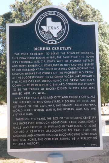
Marker Title: DICKENS CEMETERY
Marker photo by Kay Laster
Marker Location: from Dickens, take S.H. 114/U.S. 82 east, about .5 miles
UTM Easting: 331117
UTM Northing: 3721932
Marker Attached to: Post
Marker Date: 1994
Marker Text: DICKENS CEMETERY
The only cemetery to serve the town
of Dickens. This graveyard began in 1891, the same year the
town was founded. Mrs. C.F. Jones, wife of pioneer settler and
town barber C.F. Jones, died in 1891 and was buried by her
husband at the foot of a hill overlooking the Croton Breaks. The
owner of the property, M.S. Crow, at the suggestion of his
attorney, W.C. Ballard, donated five acres of land surrounding
the grave site for a community cemetery. W.C. Ballard,
considered by many to be the "Father of Dickens", died in 1913
and was buried here, as well.
Many early settlers, city and
county officials are interred in this graveyard. Also buried here
are veterans of the Civil War, the Spanish-American War,
World War I, World War II, the Korean War, and the Vietnam
War.
Through the years, the site of the Dickens Cemetery has increased through additional land donations. A fence was
erected in 1919, and in 1948 local citizens formed a cemetery
association to care for the grounds and monuments. Now,
encompassing more than eighteen acres, the cemetery serves as
a reflection of area history. 1994
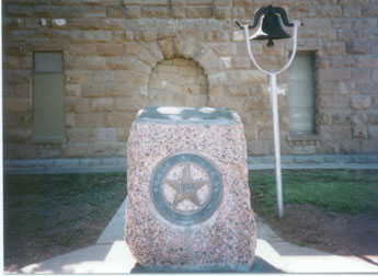
Marker Title: DICKENS COUNTY
Photo by Kay Laster
Marker Location: Courthouse Square, Highway 82, Dickens, TX.
UTM Easting: 329550
UTM Northing: 3721650
Explanation of Marker Size: pink granite highway marker; courthouse ground
Marker Date: 1936
Marker Text: Formed from Young and Bexar territories. Created Aug. 21, 1876.
Organized April 15, 1903. Dickens City, County Seat.
Marker Title: PITCHFORK RANCH
Marker Location: from Dickens, take U.S. 82 east, about 17 miles
UTM Easting: 357910
UTM Northing: 3719005
Marker Size: 18x28
Marker Attached to: Post
Marker Date: 1983
Marker Text: PITCHFORK RANCH
Irish-born, Jerry Savage established
and open range ranch at this site about 1879. In 1881, St.
Louis businessman Eugene F. Williams and Texas cattleman
Dan B. Gardner purchased the ranch and in 1883 joined forces
with landholder Sam Lazarus to form the Pitchfork Land &
Cattle Company, Inc. Williams´ heirs later acquired controlling
interest of the cattle empire. The first structures here were
dugouts in the river bank, while the present buildings date from
1902. Pitchfork Ranch has doubled it original size to 165,000
acres and now operates ranches in Kansas and Wyoming. 1983
Marker Title: FOURTH U.S. CAVALRY Photo by Ron Brantner
PRIVATES GREGG, WILLIAM MAX, W.H.
KILPATRICK & OTHER SOLDIERS
Marker Location: Spur Cemetery, local road of Highway 70, .25 miles
east of Spur city limits
UTM Easting: 329212
UTM Northing: 3705727
Marker Size: Centennial - grey granite
Marker Date: 1936
Marker Text: In Memory of:
Pvts Gregg, William Max, W. H. Kirkpatrick and other soldiers, who
met death in this region while serving under General R. S. McKenzie,
4th U.S. Calvary, 1871-1872, and 1874-1875; with no hope of honor,
if victorious; no dream of mercy, if they fell; and the certainty of death
by torture, if taken alive. They fought savage Comanches and cleared the
Plains for the white man.
Marker Title: SITE OF ANDERSON´S FORT OR SOLDIER´S MOUND Photo by Ron Brantner
Marker Location: from Spur, take Highway 70 north, about 6 miles
UTM Easting: 328674
UTM Northing: 3711056
Explanation of Marker Size: grey centennial
Marker Date: 1936
Marker Text: Here behind extensive breastworks Major Thomas M. Anderson,
Tenth U.S. Infantry, maintained a supply camp for the cavalry
under General Ranald S. Mackenzie, Fourth U.S. Cavalry who in
1874-1875 forced the Indians of the region onto reservations
and opened the plains to white settlement.
Marker Title: TEXAS AGRICULTURAL EXPERIMENT STATION AT SPUR
Marker Location: Located on FM 2794 at western city limits, Spur (school grounds near
business parking) (entrance to ag substation).
UTM Easting: 325661
UTM Northing: 3706181
Marker Size: 27" x 42" Subject
Marker Date: 1989
Marker Text:
Authorized by the Texas legislature in 1908, seven agricultural experiment
stations were established in the state. Providing facilities for agricultural
scientists to develop information and procedures and solutions to regional
agricultural problems, the stations and their programs ultimately affected
agricultural methodology far beyond regional boundaries. Known as the
rolling plains experiment station or substation No. 7, the Texas agricultural
experiment station at Spur opened at this site in December 1909. Land was
provided by the S.M. Swenson and Sons Land and Cattle Company. Soil and
water conservation programs were developed, including a system of terracing
called "Syrup Pan". Providing full use of rainfall and diverted water,
the system resulted in vastly improved crop yields. Other programs at this
station included the drafting of legislation which resulted in the
establishment of the U.S. Soil Conservation Service; brush control using
chemical, mechanical, and biological methods; and livestock breeding and
nutrition experiments. Although this station was officially closed in
1986, results of the research conducted here are still influencing
agricultural programs worldwide. 1989
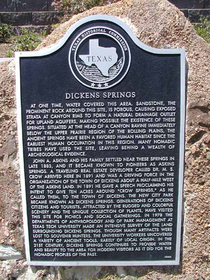
Marker Title: DICKENS SPRINGS
Index Entry: Dickens Springs
City: Dickens
County: Dickens
Subject Codes: WA, PK
Year Marker Erected: 2000
Marker Location: Dickens Springs Park on US 82, Dickens
Link to: Pictures
Marker Size: 27" x 42"
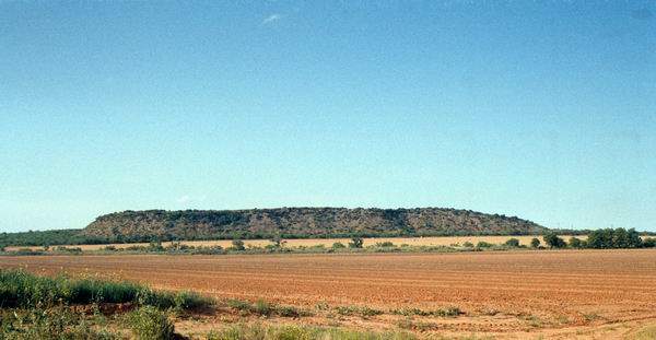
Marker Text: At one time, water covered this area. Sandstone, the prominent rock around this
site, is porous, causing exposed strata at canyon rims to form a natural drainage
outlet for upland aquifers, making possible the existence of these springs. Situated
at the head of a canyon ravine immediately below the Upper Prairie Region of the
Rolling Plains, the ancient springs have been a favored human habitat since the
earliest human occupation in this region. Many nomadic tribes have used the site,
leaving behind a wealth of archeological evidence. John A. Askins and his family
settled near these springs in late 1883, and it became known to pioneers as Askins
Springs. A traveling real estate developer called Dr. M. S. Crow arrived here in 1891
and was a driving force in the organization of the town of Dickens about a half-mile
west of the Askins land. In 1891 he gave a speech proclaiming his intent to give ten
acres around "Crow Springs," as he called them, to the town of Dickens. The new city
park became known as Dickens Springs. Generations of Dickens citizens and tourists,
attracted by the rugged and colorful scenery and the unique collection of plants,
have visited this site for picnics and social gatherings. In 1978 the departments of
Anthropology and of Park Management at Texas Tech University made an intensive survey
of the land surrounding Dickens Springs. Though many artifacts were lost to souvenir
hunters, the university workers uncovered a variety of ancient tools, rarely of local
origin. In the 21st century, Dickens Springs continues to provide water and beauty to
the area for modern visitors as it did for the nomadic peoples of the past. (2000)

Marker Title: REDMUD CEMETERY
Directions: 211 CR 496. 12 miles west of Spur on SH 261, west on CR 496 1 mile
Other Names: Tap Cemetery
County: Dickens
Year Marker Erected: 2001
Number of Graves: 372
Dates of Burials: late 19th century to present
Marker Text: First known as Tap Cemetery, as the little town of Tap was about 1/2 mile NE of this site. As Redmud Creek was nearby, it later became known as Redmud Cemetery. Will Barger homesteaded this land, and was shot by a neighbor in April 1886. His wife died of TB in July 1886 and was buried by his side. The number of graves increased and in 1906 the land owners on the north and south gave one acre each for the cemetery. In 1909 the WOW took the care of the cemetery as a project and the the day for the annual cemetery working was set on June 6, it is still observed each year. 1973
Marker Location: Redmud Cemetery,
Marker Size: Rock Boulder
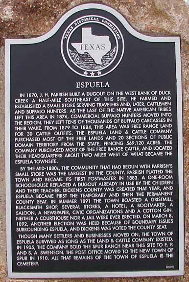
Marker Title: ESPUELA
Address: 3 mi. S of Dickens on Sh 70, 3 mi. W on FM 1868
City: Dickens
County: Dickens
Year Marker Erected: 2002
Marker Location: 3 mi. S of Dickens on Sh 70, 3 mi. W on FM 1868
Marker Size: 27" x 42"
Marker Text: In 1870, J.H. Parrish built a dugout on the west bank of Duck Creek a half-mile
southeast of this site. He farmed and established a small store serving travelers
and, later, cattlemen and buffalo hunters. As the last of the Native American tribes
left this area in 1876, commercial buffalo hunters moved into the region. They left
tens of thousands of buffalo carcasses in their wake. From 1879 to 1884, this area
was free range land for 30 cattle outfits. The Espuela Land & Cattle Company
purchased most of the free lands and 20 sections of public domain territory from
the state, fencing 569,120 acres. The company purchased most of the free range
cattle, and located their headquarters about two miles west of what became the
Espuela townsite. By the mid-1880s, the community that had begun with Parrish's
small store was the largest in the county. Parrish platted the town and became its
first postmaster in 1883. A one-room schoolhouse replaced a dugout already in use by
the children and their teacher. Dickens County was created that year, and Espuela
became first the temporary and then the permanent county seat. In summer 1891 the
town boasted a gristmill, blacksmith shop, several stores, a hotel, a bootmaker, a
saloon, a newspaper, civic organizations and a cotton gin. Neither a courthouse nor a
jail were ever erected. On March 8, 1892, another election was held because of
boundary issues surrounding Espuela, and Dickens was voted the county seat. Though
many settlers and businesses moved on, the town of Espuela survived as long as the
land & cattle company existed. In 1905, the company sold the Spur Ranch near this
site to E.P. and S.A. Swenson. The post office moved to the new town of Spur in 1910.
All that remains of the town of Espuela is the cemetery. 2000
Marker Title: MARSHALL CLINTON FORMBY, JR. (APR. 12, 1911 - DEC. 27, 1984)
Index Entry: Formby, Jr., Marshall Clinton, (APR. 12, 1911 - DEC. 27, 1984)
Address: McAdoo Cemetery, 1.5 mi. SW of McAdoo on CR 103
City: McAdoo
County: Dickens
Year Marker Erected: 2003
Marker Location: McAdoo Cemetery, 1.5 mi. SW of McAdoo on CR 103
UTM Easting: 314181
UTM Northing: 3728781
Marker Size: Grave Marker
Marker Text: Marshall Clinton Formby, Jr. (APR. 12, 1911 - DEC. 27, 1984) Marshall Formby moved
with his family from Hopkins County, Texas, to McAdoo at the age of five and worked
most of his life for the betterment of West Texas. A graduate of Spur High School,
Formby earned a degree in government from Texas Tech University before serving in
World War II. A pioneer radio station owner in several West Texas towns, he later
completed a law degree. His public service continued as a Texas Highway Commissioner
and member of the Texas Tech Board of Regents. Active on many civic and cultural
boards, Formby received numerous honors and awards. Recorded - 2002
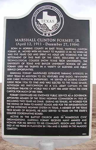
Marker Title: MARSHALL CLINTON FORMBY, JR.
Index Entry: Formby, Marshall Clinton, Jr.
City: McAdoo
County: Dickens
Year Marker Erected: 2003
Marker Location: 3 mi. S of McAdoo on FM 264 at intersection with US 82
Marker Size: 27" x 42"
Marker Text: Marshall Clinton Formby, Jr. (April 12, 1911 - December 27, 1984) Born in Hopkins
County in East Texas, Marshall Clinton Formby, Jr., moved with his family to McAdoo
(3 MI. N) when he was five years old and spent his adult life working for the
betterment of this part of the state. Educated at Texas Technoligical College (NOW
Texas Tech University), the University of Texas and Baylor University School of Law,
Formby used his talents in a variety of business and public service opportunities.
Marshall Formby maintained extensive farming interests in West Texas in addition to
oil ventures and radio, newspaper and cable television enterprises. He served as
Dickens County Judge from 1936 to 1940 and was elected to the Texas Senate, although
his participation as a U.S. Army Captain in the European Theatre of World War II kept
him away from the State Capitol and much of his term. Formby continued his statewide
public service as a Governon-Appointed member of the Texas Highway Commission in
1953-59, including two years as chair. During his tenure, he worked for the paving of
farm to market roads and for the implementation of the interstate highway system in
Texas. A member of the Texas Tech Board of Regents, he also served 12 years on the
state's college coordinating board. Active in the Baptist Church adn in numerous
civic organizations, Marshall Formby received many awards and honors for his service
to his community, region and state. He died at his home in Plainview in 1984 and is
buried in the McAdoo Cemetery.
© Dickens County Historical Commission 1997-2022
This site may be freely linked to but not duplicated in any fashion without consent.
The information on these pages is meant for personal genealogical
research only and is not for commercial use of ANY type.
|
|

