This website best viewed with Internet Explorer Browser
|
|
Top of Page
|
|
|
|||||||||||||||||||||||||||||||||||||||||||||||||
|
|
|
|||||||||||||||||||||||||||||||||||||||||||||||||||
|
|
|
|||||||||||||||||||||||||||||||||||||||||||||||||||
|
|
|
|
||||||||||||||||||||||||||||||||||||||||||||||||||
|
|
|
|
||||||||||||||||||||||||||||||||||||||||||||||||||
|
|
|
|||||||||||||||||||||||||||||||||||||||||||||||||||
|
|
|
|||||||||||||||||||||||||||||||||||||||||||||||||||
Introduction
INTRODUCTION |
|
|||||||||||||||||||||||||||||||||||||||||||||||||||
|
|
|
|
|
|||||||||||||||||||||||||||||||||||||||||||||||||
|
|
|
|||||||||||||||||||||||||||||||||||||||||||||||||||
|
|
|
|
|
|||||||||||||||||||||||||||||||||||||||||||||||||
List of
routes
LIST OF ROUTES
The following historic roads, trails and migration routes are defined as having their terminus in present day Montana, Idaho, Wyoming, as well as northern and central Nevada, Utah, and Colorado. |
|
|
||||||||||||||||||||||||||||||||||||||||||||||||||
|
||||||||||||||||||||||||||||||||||||||||||||||||||||
Seaerching for a Keyword
Looking for A Specific Place or Keyword?? Use the “Find” function in the Edit pull down menu. You can also access this function by holding down the Control key while pressing the F key (Ctrl+F) on your keyboard. |
|
|||||||||||||||||||||||||||||||||||||||||||||||||||
Dealing with
a Broken Link
Broken Link!!! If you encounter a broken information link Cut & Paste the entry to your browser’s search component. |
|
|||||||||||||||||||||||||||||||||||||||||||||||||||
Keys to more
information and resources
Keys to the Information and Other Resources
Route: 5E1; Info. Link: (1); Map: (1); Image Gallery: (1) Image Gallery = Link to a gallery of images that pertain to the route. Map = link to a map of this route. These maps have been developed from accounts found in various research sources. The route lines, on each map, have been linked to the current modern roads found to be the closest to the original route descriptions. Locations marked along the route are usually places named within the aforementioned research sources. Info. Link = link to a webpage containing additional facts about this route. Route = each route has a specific Identifier code (ID Code). Each ID Code includes a number that identifies the cultural / geographical area of the United States in which we have developed information about the route, the letter of the alphabet under which it is filed and a dedicated number for the route. Thus data about the route designated as 5C2 would be found on the webpage for “Routes of the Southeastern Gulf Plains”, filed under the letter C route number 2*. *The specific route number will not conform to a descending order as new routes are added to the database. |
|
|||||||||||||||||||||||||||||||||||||||||||||||||||
Keys to the
routes
Links to the Routes
Use the “letter keys” to quickly locate an historic route. Each identified route is listed alphabetically along with links to additional information, places where the route terminates, as well a short descriptive paragraph about importation aspects of the route. |
|
|||||||||||||||||||||||||||||||||||||||||||||||||||
|
||||||||||||||||||||||||||||||||||||||||||||||||||||
|
||||||||||||||||||||||||||||||||||||||||||||||||||||
A
|
Name (Links to Resources) |
Places of Termination |
Descriptive Information |
|
||||||||||||||||||||||||||||||||||||||||||||||||
|
Alma and Breckenridge Road Route 8A1; Info. Link (1); Map (1); Images (1) |
Route chartered in 1880 via Hoosier Pass. From Alma then up the Platte Valley and across Hoosier Pass to the Blue River then down the Blue River to Breckenridge. § |
|
||||||||||||||||||||||||||||||||||||||||||||||||||
|
Armijo’s Route |
Alternate route of the Old Spanish Trail that leaves the main route at the junction of US 84 and NM Route 96 near the Abiguiu Reservoir and travels west for almost 500 miles until it rejoins the main route at at Shivwits on the Paiute Indian Reservation in southern Utah. |
|
||||||||||||||||||||||||||||||||||||||||||||||||||
|
Aspen and Grand River Road Route 8A3; Info. Link (1); Map (1); Images (1) |
Built by the Western Colorado and Grand River Toll Road Company around 1880. The route ran from Aspen down the Roaring Fork to the mouth of the Frying Pan Creek then west along the Grand River* to the west line of Colorado. § * Name changed to Colorado River in 1921 |
|
||||||||||||||||||||||||||||||||||||||||||||||||||
|
Aspen, Hunter Creek, and Leadville Road Route 8A4; Info. Link (1); Map (1); Images (1) |
A toll road chartered in 1880 to run from Aspen then up Hunter Creek to the apex of the Continental Divide then east to city of Leadville. § |
|
||||||||||||||||||||||||||||||||||||||||||||||||||
|
Aspen, Maroon Creek, and Gothic Road Route 8A5; Info. Link (1); Map (1); Images (1) |
A toll road chartered in 1885 to run from Aspen, Pitkin County, crossing Castle Creek to the east bank of Maroon Creek, then up Maroon Creek and up Elk Mountain and connecting with Silver Knight Road in Gunnison County to or near Gothic in Gunnison County. § |
|
||||||||||||||||||||||||||||||||||||||||||||||||||
|
|
|
|||||||||||||||||||||||||||||||||||||||||||||||||||
B
|
Name (Links to Resources) |
Places of Termination |
Descriptive Information |
|
||||||||||||||||||||||||||||||||||||||||||||||||
|
Bakerville and Leadville Road Route 8B1; Info. Link (1); Map (1); Images (1) |
This route was established in 1879 to start at Bakerville, Clear Creek County, then running up the main branch of South Clear Creek southwesterly on the best route to Loveland Pass, then down the west slope of Summit County along the north Snake River to the south or main Snake River to bridge crossing Blue River near and above mouth of Ten Mile Creek then up the valley of Ten Mile Creek to Carbonateville via Chalk Ranche and Chalk Mountain to Leadville. § |
|
||||||||||||||||||||||||||||||||||||||||||||||||||
|
Bidwell-Bartleson Route in Idaho & Utah Route 8B2; Info. Link (1); Map (1); Images (1) |
Near Alexander, Idaho this route leaves the Oregon Trail going south along the Bear River. The Bidwell-Bartleson party left Utah near Wendover in Box Elder County at approximately N41.019516° W114.041907°. |
|
||||||||||||||||||||||||||||||||||||||||||||||||||
|
Bidwell-Bartleson Route in Nevada Route 8B3; Info. Link (1); Map (1); Images (1) |
The route entered Nevada near West Wendover, Elko County, Nevada at approximately N41.019516° W114.041907°. Between Wells and Lovelock the route approximated present day Interstate 80. It exited Nevada near Wellington on the Walker River at about N38.650718° W119.495314°. |
|
||||||||||||||||||||||||||||||||||||||||||||||||||
|
Birds Eye and Leadville Road Route 8B4; Info. Link (1); Map (1); Images (1) |
A toll road chartered in 1880 to run from Birdseye (north of Birdseye Gulch) to Leadville. § |
|
||||||||||||||||||||||||||||||||||||||||||||||||||
|
Bishop Creek Route |
Opened in 1843 by Joseph Walker, this cutoff of the California Trail goes west through Bishop Canyon to the Humboldt River. Most of the emigrants went this way. |
|
||||||||||||||||||||||||||||||||||||||||||||||||||
|
Blue River, Black Lake, & Mount Powell Rd. Route 8B6; Info. Link (1); Map (1); Images (1) |
Chartered in 1880 as a toll road from where the county wagon road crosses Black Lake Creek, 300 yards south of the Blue River, then following the west bank of stream to just below the outlet of Black Lake and finally to the inlet of Black Lake. § |
|
||||||||||||||||||||||||||||||||||||||||||||||||||
|
Bozeman Trail |
An overland route connecting Child’s Cutoff of the Oregon Trail to the gold rush territory of Montana. Its most important period was from 1863-1868. |
|
||||||||||||||||||||||||||||||||||||||||||||||||||
|
Breckenridge, Buckskin Joe Gulch, and Hamilton Wagon Road Route 8B8; Info. Link (1); Map (1); Images (1) |
This route was created in 1861 to run from Breckenridge up Blue River and Hoosier Gulch thru Ute [Hoosier] Pass, then down [South] Platte River to Buckskin Joe Gulch. Also a branch of road from Hamilton then up bank of Tarryall Creek following Left Hand Fork toward summit of mountain and along same to a point intersecting the main line of said road in Montgomery Mining District. § |
|
||||||||||||||||||||||||||||||||||||||||||||||||||
|
Bridger Trail Route 8B9; Info. Link (1); Map (1); Images (1) |
The Bridger Trail left the main Oregon Trail, at a point on the north fork of the Platte River, a short distance east of Independence Rock, Wyoming. It proceeded northward, the trail crossed tributaries of the Big Horn River, entering Montana west of the Pryor Mountains, in what is now Carbon County; then, in a northwesterly direction, reaching the Clark’s fork of the Yellowstone, the trail struck that river at the mouth of Bridger Creek, in what is now Sweetgrass County. The Bridger Trail proceeded along the Yellowstone River to the mouth of Shield’s River, up this tributary and a western branch of the same, through Bridger Pass of the Bridger range of mountains, down Bridger Creek and through Bridger Canyon to the present site of Bozeman, where Jim Bridger arrived with a train in 1864. From Bozeman in a southwesterly direction, the Trail led to Virginia City and Bannack. |
|
||||||||||||||||||||||||||||||||||||||||||||||||||
|
Bryan-South Pass Road |
With the completion of the Union Pacific Railroad across southern Wyoming, a series of stage and freight wagon roads were developed to serve fledgling communities to the north. One of these roads, the Bryan-South Pass Road was established in 1868 to serve the boom town of South Pass City that sprang to life following gold discoveries along the upper Sweetwater region in 1867. |
|
||||||||||||||||||||||||||||||||||||||||||||||||||
|
Buena Vista, Aspen City, & White River Road Route 8B11; Info. Link (1); Map (1); Images (1) |
This 1880 route connected Buena Vista in Chaffee County to the White River Agency in Summit County. From Buena Vista up Cottonwood Creek then over Cottonwood Pass into Taylor Park. Then up Taylor River and through Taylor Park and across the divide at the head of Taylor Park. Then to the head of Castle Creek, then down Castle Creek to Highland. Then north to Aspen. Then down Roaring Fork Creek to Grand River. Then northwest to White River Indian Agency. § |
|
||||||||||||||||||||||||||||||||||||||||||||||||||
|
|
|
|||||||||||||||||||||||||||||||||||||||||||||||||||
C
|
Name (Links to Resources) |
Places of Termination |
Descriptive Information |
|
||||||||||||||||||||||||||||||||||||||||||||||||
|
California Trail in Idaho & Utah |
The eastern terminus of the California Trail is located on the Oregon Trail at the Raft River Crossing. From here it lead southwest through Granite Pass to where it enters Utah at N41.992493° W113.991224°. It then follows along Goose Creek for about four miles to where it enters Elko County, Nevada along State Route 7 near N41.964512° W114.041077°. |
|
||||||||||||||||||||||||||||||||||||||||||||||||||
|
California Trail in Nevada Route 8C2; Info. Link (1); Map (1); Images (1) |
The eastern terminus of the California Trail in Nevada is in Elko County along State Route 7 near N41.964512° W114.041077°. From here the main stem of the California Trail continues in a south westerly direction for about 389 miles through Nevada to a point about 24 miles southwest of Lovelock, Nevada, near Interstate 80 where the “Stem Route” parts to form the “Truckee Route” and the “Carson Route.” See Truckee Route in Nevada (8T4), or Carson Route in Nevada (8C5) for more information. |
|
||||||||||||||||||||||||||||||||||||||||||||||||||
|
Carbonateville Road to White River Agency Route 8C3; Info. Link (1); Map (1); Images (1) |
Circa 1880 road from Carbonateville**, in Summit County, at approximately N39.393840° W106.190804°, to the White River Agency. From Carbonateville west to Eagle River, then down Eagle River via Eagle City, Red Cliff to the junction of said Eagle River with the Grand River*. This part of the route follows present day U.S. 24. Then along the Grand River and near the Old Ute Trail to the White River Indian Agency near N40.091343° W108.224360°. § * Name changed to Colorado River in 1921. ** The site of Carbonateville is near the Lake and Summit County line and may actually be in Summit County. |
|
||||||||||||||||||||||||||||||||||||||||||||||||||
|
Carroll Trail |
A wagon road in Montana established c. 1874 used to ship freight from Carroll Landing* on the Missouri River to the Montana gold fields. AKA. Helena-Carroll Wagon Road, Helena Road. *Carroll Landing was located approximately 15 miles downstream from the current junction of the Missouri River and US Route 191. |
|
||||||||||||||||||||||||||||||||||||||||||||||||||
|
Carson Route in Nevada |
A major branch route of the California Trail. The first route near the present US Highway 50 was laid out in 1848 by an eastward Mormon party that wanted to avoid the Truckee Route and its deep crossings of the Truckee River. Through California, the general alignment of the Carson Route, in terms of today's highways, is State Route 88 over Carson Pass, then Iron Mountain Road to US Highway 50. The Nevada segment of the Carson Route enters California at South Lake Tahoe in El Dorado County California. See also California Trail in Nevada. |
|
||||||||||||||||||||||||||||||||||||||||||||||||||
|
Central City and Montgomery Wagon Road Route 8C6; Info. Link (1); Map (1); Images (1) |
A road chartered in 1864 to operate from Central City via Breckenridge to Montgomery with a branch to Jefferson. § |
|
||||||||||||||||||||||||||||||||||||||||||||||||||
|
Central Overland Route Route 8C7; Info. Link (1); Map (1); Images (1) |
The Central Overland Trail was a shortcut of the California Trail. It was opened by the U.S. Army in 1859 from Salt Lake City, Utah through central Nevada to Carson City, Nevada, a distance of about 650 miles (1046 km). This more direct route shaved off 280 miles (450 km), about two weeks travel time, from the length of the original California Trail. Also known as Central Route, Central Nevada Route, Simpson's Route, Egan Trail, and Pony Express Trail. |
|
||||||||||||||||||||||||||||||||||||||||||||||||||
|
Chalk Creek and Elk Mountain Road Route 8C8; Info. Link (1); Map (1); Images (1) |
This route from about N38.692389° W106.413773° on Chalk Creek crossed Tin Cup Pass and over Taylor Pass to Ashcroft and then Aspen. § |
|
||||||||||||||||||||||||||||||||||||||||||||||||||
|
Chalk Creek Ranch, Carbonateville, Ten Mile, and Kokomo Road Route 8C9; Info. Link (1); Map (1); Images (1) |
A 1879 road from Chalk Creek Ranch believed to be located approximately near N39.368992° W106.220406° in Lake County near the line between Lake and Summit Counties. Then to Carbonateville then by Robinson mine to Kokomo in Summit County over the route known as Horse and Foot Trail from Chalk Creek Ranch to Ten Mile and Kokomo. § |
|
||||||||||||||||||||||||||||||||||||||||||||||||||
|
Cherokee Trail |
Followed the Arkansas River from Oklahoma through Kansas, Colorado, and into Wyoming, where it met the California Trail at Ft. Jim Bridger. Used in the Gold Rush Days.. Also known as the Overland-Cherokee Trail. |
|
||||||||||||||||||||||||||||||||||||||||||||||||||
|
Child's Cutoff |
Originally travelers on the Emigrant Trail crossed the North Platte to the south side at Fort Laramie. After 1852 they used Child's Cutoff to stay on the north side to about the present day town of Casper, Wyoming where they crossed over to the south side. |
|
||||||||||||||||||||||||||||||||||||||||||||||||||
|
Colorado and California Wagon Road Route 8C12; Info. Link (1); Map (1); Images (1) |
Route established in 1867 to travel from a point 6 miles west of Empire City to Bear River to a point on the Denver & Pacific Wagon Road opposite the point where the Berthoud Trail intersects with said road then up the north side of Clear Creek to Jones Pass, over the pass to head of Williams Fork of the Grand River*, then down Williams Fork to Middle Park and west to Grand River and Gore Pass to Bear River near present day Steamboat Springs. § * Name changed to Colorado River in 1921 |
|
||||||||||||||||||||||||||||||||||||||||||||||||||
|
Copper Creek and Maroon Road |
A toll road chartered in 1880 starting from the northeast line of survey of Gothic City and running along Copper Creek to the summit of the divide, at approximately N39.001122° W106.941190° between Copper Creek and Maroon Creek in Gunnison County. § |
|
||||||||||||||||||||||||||||||||||||||||||||||||||
|
Crystal River Road Route 8C14; Info. Link (1); Map (1); Images (1) |
The Crystal River Road Company was formed in 1886 to construct a route from the town of Marble, on the west bank of Crystal River near the confluence of Yule Creek in Gunnison County, down the valley of Crystal River to the point known as Satank, now Carbondale, in Garfield County. § |
|
||||||||||||||||||||||||||||||||||||||||||||||||||
|
|
|
|||||||||||||||||||||||||||||||||||||||||||||||||||
D
|
Name (Links to Resources) |
Places of Termination |
Descriptive Information |
|
||||||||||||||||||||||||||||||||||||||||||||||||
|
Daggett Pass Trail |
near Minden, NV near Stateline, NV |
Named
for Charles D. Daggett who in 1854 staked a claim on 640 acres along what was
then known as the Georgetown Trail. The route branched off of the Carson
Route and follows NV 207 west over Daggett Pass to join the Johnson
Cutoff. AKA. Georgetown-Daggett Pass Trail. |
|
|||||||||||||||||||||||||||||||||||||||||||||||||
|
Deep Creek and White River Road Route 8D1; Info. Link (1); Map (1); Images (1) |
1883. From the mouth of the Eagle River, at Dotsero, up the northeast side of Deep Creek and down the South Fork of White River to the old White River Agency with a bridge from at or near the head of Grizzly Gulch to Carbonate, Garfield County. § |
|
||||||||||||||||||||||||||||||||||||||||||||||||||
|
Denver, Bradford, & Blue River Wagon Rd. Route 8D2; Info. Link (1); Map (1); Images (1) |
1861. From Denver via Bradford, North Fork of the South Platte River, and Hamilton in South Park, to Breckenridge on the Blue River in Middle Park, with a branch from a junction 10 miles from Bradford, on the main line of said road, to Clear Creek, or Vasquez Fork, near Golden City. § |
|
||||||||||||||||||||||||||||||||||||||||||||||||||
|
Dotsero Toll Road Route 8D3; Info. Link (1); Map (1); Images (1) |
1883. From a bridge that crosses Eagle River above the mouth of Gypsum Creek in Eagle County then west along north bank of Eagle River to town of Dotsero. § |
|
||||||||||||||||||||||||||||||||||||||||||||||||||
|
|
|
|||||||||||||||||||||||||||||||||||||||||||||||||||
E
|
Name (Links to Resources) |
Places of Termination |
Descriptive Information |
|
||||||||||||||||||||||||||||||||||||||||||||||||
|
Eagle City and Leadville Road Route 8E1; Info. Link (1); Map (1); Images (1) |
1879. From Eagle City via Fishback(?) to Leadville, a wagon road. Beginning at southern line of Eagle City, then up to Piney on Tennessee Creek crossing the range at Tennessee Pass, then down the Tennessee Fork of the Arkansas River about one and a half miles then along the base of the mountain on north side of said stream and crossing the Arkansas River near the mouth of Big Evans Gulch, thence in a southerly direction and entering Leadville from a northerly direction in Summit and Lake Counties. § |
|
||||||||||||||||||||||||||||||||||||||||||||||||||
|
Eagle City and White River Toll Road Route 8E2; Info. Link (1); Map (1); Images (1) |
Company, v. B, p. 280–282, October 27, 1879. From the north end of 5th Street in Eagle City then westerly to the base of Baxter Mountain then down the Eagle River via Redcliff to its junction with the Grand River*, then along the Grand River and near the Ute Trail to the White River Indian Agency in the State of Colorado. § * Name changed to Colorado River in 1921 |
|
||||||||||||||||||||||||||||||||||||||||||||||||||
|
Eagle River & Gunnison Valley Wagon Road Route 8E3; Info. Link (1); Map (1); Images (1) |
This 1880 wagon road went from a little beyond Battle Mountain, down Eagle River, then southwest to the Roaring Fork River and into the Gunnison Country, and to Summit County, and to Gothic City, Gunnison County. § |
|
||||||||||||||||||||||||||||||||||||||||||||||||||
|
Eagle River Road Route 8E4; Info. Link (1); Map (1); Images (1) |
1880. From the county line on Tennessee Pass Road and at present day U.S. Route 24, down Buckeye Gulch to Eagle City then along Eagle River about 10 miles below the junction of Brush Creek on Eagle River, then by way of Gypsum Creek Pass (Cottonwood Pass) to the junction of Frying Pan Creek with the Roaring Fork then following along Roaring Fork to near the junction with Castle Creek, then up Castle Creek to the town of Highland, then beginning at a point where the above route leaves the Eagle River continuing down said Eagle River to its mouth at Dotsero. § |
|
||||||||||||||||||||||||||||||||||||||||||||||||||
|
Empire and Grand River Wagon Road Route 8E5; Info. Link (1); Map (1); Images (1) |
1880. From Empire west 5.5 miles to Freeman Sawmill in Atlantic Mining District, then from north of old Freeman Sawmill on the Georgetown & Middle Park Wagon Road up the valley of Middle Clear Creek through town of Atlantic and the District of Atlantic in Clear Creek County and along the north bank of Middle Clear Creek about 4 miles to where the "Old Jones Road" crosses said Middle Clear Creek on its way to Jones Pass, then along a line of said Jones Road down to the headwaters of Williams Fork then down Williams Fork along Jones Road to the Grand River*, at Parshall, in Grand County, Colorado. § * Name changed to Colorado River in 1921 |
|
||||||||||||||||||||||||||||||||||||||||||||||||||
|
Empire and White River Wagon Road Route 8E6; Info. Link (1); Map (1); Images (1) |
1871. From Empire City, Clear Creek County, to White River Indian Agency starting at western boundary line of Empire City on "best" route up Middle Fork of South Clear Creek, via Freeman's Saw Mill and thru Berthoud's Pass, to Hot Sulphur Springs on Grand River* in Summit County and by "best" route thru Gore's Pass to White River Indian Agency, the end. § * Name changed to Colorado River in 1921 |
|
||||||||||||||||||||||||||||||||||||||||||||||||||
|
Empire City, New Pass (Loveland Pass), Breckenridge and Montgomery City Road Route 8E7; Info. Link (1); Map (1); Images (1) |
From Empire City to Georgetown, via South Fork of Vasquez River (Clear Creek) over Loveland Pass and to Breckenridge and then Montgomery City on head of South Platte River. § |
|
||||||||||||||||||||||||||||||||||||||||||||||||||
|
|
|
|||||||||||||||||||||||||||||||||||||||||||||||||||
F
|
Name (Links to Resources) |
Places of Termination |
Descriptive Information |
|
||||||||||||||||||||||||||||||||||||||||||||||||
|
Fort Kearny Road |
|
see Lander Road |
|
|||||||||||||||||||||||||||||||||||||||||||||||||
|
Frémont Cutoff |
|
A modification to the Old Spanish trail created by John C. Frémont in 1844 when his expedition left the Armijo Route at Resting Spring and turned northeastward after crossing the Nopah Range through Emigrant Pass, through California Valley and across Pahrump Valley to Stump Spring and into the mountains to Mountain Springs, to Cottonwood Spring, to Las Vegas Springs. He then crossed the dry 50 miles to the Muddy River before rejoining the Main Route on the Virgin River at N36.675453° W114.291939°. |
|
|||||||||||||||||||||||||||||||||||||||||||||||||
|
|
|
|||||||||||||||||||||||||||||||||||||||||||||||||||
G
|
Name (Links to Resources) |
Places of Termination |
Descriptive Information |
|
||||||||||||||||||||||||||||||||||||||||||||||||
|
Georgetown and Breckenridge Wagon Road Route 8G1; Info. Link (1); Map (1); Images (1) |
1869. From Georgetown up west branch of South Clear Creek to junction of Grizzly Fork, up Grizzly Fork and thru Irwin Pass on North Fork Snake River then down Snake River and up Blue River to Breckenridge. Also a branch road from junction of Kelso Creek then up Kelso Creek. § |
|
||||||||||||||||||||||||||||||||||||||||||||||||||
|
Georgetown and Ten Mile Road Route 8G2 Info. Link (1); Map (1); Images (1) |
1879 From Georgetown and over the range and down the Snake River and up the creek from Snake River to Montezuma, then by way of Ten Mile Creek to Recen and Kokomo and by a feasible route to Leadville. Stages from Denver to Georgetown operated from 1879 to 1886. § |
|
||||||||||||||||||||||||||||||||||||||||||||||||||
|
Glenwood Springs, Carbonate, and Eagle River Wagon Road Route 8G3 Info. Link (1); Map (1); Images (1) |
A toll road established in 1885 to start at Glenwood Springs in Garfield County up and along on either side of the Grand River* crossing it by bridges, ferries, or fords to the mouth of Grizzly Creek then up said creek to Carbonate then up river to mouth of Eagle River at Dotsero in Eagle County. § * Name changed to Colorado River in 1921 |
|
||||||||||||||||||||||||||||||||||||||||||||||||||
|
Goodale's Cutoff |
Emigrant wagons traversed parts of the eastern section of this route as early as 1852. The complete trail, established in 1862, formed a spur of the Oregon Trail. The route traveled along the north side of the Snake River from Fort Hall, now Pocatello, to Ditto Creek where it joined back with the Oregon Trail. A branch of the Lander Road (Cut-Off) from Blackfoot, ID joined with Goodale’s route near Southern Butte in, Idaho County. The 230 mile journey typically took 2 to 3 weeks to complete. Today the route approximates a part of U.S. Route 20. |
|
||||||||||||||||||||||||||||||||||||||||||||||||||
|
Goodnight-Loving Trail |
Spanning more than 2,000 miles from Texas to Wyoming, this livestock trail was first blazed by Charles Goodnight and Oliver Loving in 1866. |
|
||||||||||||||||||||||||||||||||||||||||||||||||||
|
Grand and White River Road Route 8G6; Info. Link (1); Map (1); Images (1) |
Two routes were established in 1882. The first to run from present day Dotsero on the Grand River* opposite the mouth of Eagle River, then following the Old Ute Trail in a northwest direction to the White River Agency. A second route commencing again on the Grand River, at present day Glenwood Springs, opposite the mouth of Roaring Fork River then running north up and across Grizzly Canon Creek and to the head of said creek, there forming a junction with the road projected from the mouth of Eagle River to the White River Indian Agency now White River City. § * Name changed to Colorado River in 1921 |
|
||||||||||||||||||||||||||||||||||||||||||||||||||
|
Grand River and Carbonate Road Route 8G7; Info. Link (1); Map (1); Images (1) |
1883 From the west end of the bridge crossing the Grand River* above the mouth of the Eagle River then west along a dry gulch and near the old Ute Trail to White River Agency, from thence south to Coffee Pot Springs, then west to the terminus at Carbonate. § * Name changed to Colorado River in 1921 |
|
||||||||||||||||||||||||||||||||||||||||||||||||||
|
Greenhorn Cutoff |
near Moleen, Elko Co., NV |
This trail was developed to bypass the narrow 5 mile long Carlin Canyon, on the Humboldt River, when it flooded. |
|
|||||||||||||||||||||||||||||||||||||||||||||||||
|
|
|
|||||||||||||||||||||||||||||||||||||||||||||||||||
H
|
Name (Links to Resources) |
Places of Termination |
Descriptive Information |
|
||||||||||||||||||||||||||||||||||||||||||||||||
|
Hamilton and Breckenridge Wagon Road Route 8H1; Info. Link (1); Map (1); Images (1) |
An 1867 road from Hamilton, Park County, then along north side of Tarryall Creek thru Tarryall to the base of the range then via the Breckenridge [Boreas] Pass to the summit of the range then down the north side of Indiana Gulch to the valley of the Blue to Breckenridge, Summit County. § |
|
||||||||||||||||||||||||||||||||||||||||||||||||||
|
Hamilton and Montgomery Wagon Road Route 8H2; Info. Link (1); Map (1); Images (1) |
Route created in 1866 from Hamilton via Tarryall, Dead Wood, and Little French Creek, across the range and ending at Montgomery. § |
|
||||||||||||||||||||||||||||||||||||||||||||||||||
|
Hastings Cutoff |
The cutoff left the Oregon Trail at Fort Bridger in Wyoming, passed through the Wasatch Range, across the Great Salt Lake Desert, an 80-mile waterless drive, looped around the Ruby Mountains, and rejoined the California Trail at Emigrant Pass located about seven miles west of modern Elko at N40.655379° W116.273606°. |
|
||||||||||||||||||||||||||||||||||||||||||||||||||
|
Helena Road |
|
see Carroll Trail |
|
|||||||||||||||||||||||||||||||||||||||||||||||||
|
Helena-Carroll Wagon Road |
|
see Carroll Trail |
|
|||||||||||||||||||||||||||||||||||||||||||||||||
|
Honeymoon Trail |
This route was the southern segment of the Mormon Wagon Road that extended north to Salt Lake City. It was utilized by Mormon colonizers of Arizona for travel to the closest temple in St. George, Utah to be married. Thus it was also called the “Honeymoon Trail.” The main route crossed the Colorado River at Lee’s Ferry. South of the river, the main road headed almost due south, much of it alongside the Little Colorado River, to Sunset Crossing, where Winslow is today. From here, branches led to Mormon colonies in the Tonto Basin and the upper Little Colorado River Valley. An important part of this trail system also continued from Show Low southward to the Upper Gila River Valley. The distances of the various branches combined amounted to more than 450 miles. |
|
||||||||||||||||||||||||||||||||||||||||||||||||||
|
Hudspeth's Cutoff |
Established in 1849 as a route to the California gold fields. This 110-mile trail left the Oregon Trail about seven miles west of Soda Springs near the present day junction of U.S. Rt. 30 and ID State Rt. 34. It headed almost due west to where it rejoined the California Trail at Cassia Creek near Malta, ID. |
|
||||||||||||||||||||||||||||||||||||||||||||||||||
|
Hundred (100) Mile Route |
|
see Meeteetsee Trail |
|
|||||||||||||||||||||||||||||||||||||||||||||||||
|
|
|
|||||||||||||||||||||||||||||||||||||||||||||||||||
I
|
Name (Links to Resources) |
Places of Termination |
Descriptive Information |
|
||||||||||||||||||||||||||||||||||||||||||||||||
|
Route 9X1; Info. Link (1); Map (1); Images (1) |
|
|||||||||||||||||||||||||||||||||||||||||||||||||||
|
|
|
|||||||||||||||||||||||||||||||||||||||||||||||||||
J
|
Name (Links to Resources) |
Places of Termination |
Descriptive Information |
|
||||||||||||||||||||||||||||||||||||||||||||||||
|
Route 9X1; Info. Link (1); Map (1); Images (1) |
|
|||||||||||||||||||||||||||||||||||||||||||||||||||
|
|
|
|||||||||||||||||||||||||||||||||||||||||||||||||||
K
|
Name (Links to Resources) |
Places of Termination |
Descriptive Information |
|
||||||||||||||||||||||||||||||||||||||||||||||||
|
Kelton Road |
This route was developed in 1860 from roughly the _City of Rocks_ via the main Oregon Trail to Boise crossing to the North side of the Snake River at Three Island Crossing or _Glenn's Ferry_. In 1869 the Road was extended from City of Rocks to Kelton, Utah to connect with the new Transcontinental Railroad. |
|
||||||||||||||||||||||||||||||||||||||||||||||||||
|
Kinney Cutoff Route 8K2; Info. Link (1); Map (1); Images (1) |
The Kinney Cutoff departs to Oregon Trail in Sweetwater County, Wyoming near the Lombard Ferry crossing of the Green River at about N41.876621° W109.806169°. After crossing the Green at several different points the cutoff soon reached the valley of Slate Creek, hence the name west of the Green River, Slate Creek Cutoff. The trail follows up Slate Creek about 12 miles to Emigrant Springs. From the springs it was an easy drive to the foot of Slate Creek Ridge, but the climb directly up the east slope of the ridge was an arduous one. After passing Slate Creek Ridge the Cutoff merges with the Sublette-Greenwood Cutoff near Rocky Gap. |
|
||||||||||||||||||||||||||||||||||||||||||||||||||
|
|
|
|||||||||||||||||||||||||||||||||||||||||||||||||||
L
|
Name (Links to Resources) |
Places of Termination |
Descriptive Information |
|
||||||||||||||||||||||||||||||||||||||||||||||||
|
Lander Road (ID) |
The Lander Road entered Idaho near Stump Creek Rd. (State Rt. 29) in Carabou County. From there it ran north to Lander Creek where it split with one branch going south the Soda Springs to join back to the Oregon Trail. The other branch went west to Blackfoot and joined Goodale’s Cut-Off. |
|
||||||||||||||||||||||||||||||||||||||||||||||||||
|
Lander Road (WY) |
Formally known as the Fort Kearney Road and South Pass Road, was established and built by government contractors in 1858 the only westward emigrant traill that was specifically built as a road for use by the emigrants.. It departed the main Oregon Trail at Burnt Ranch and crossed the Continental Divide north of South Pass. It then traveled west south of Big Sandy and north of Big Piney before crossing the Wyoming Range and descending into Star Valley. This segment of the route ended near Auburn, WY. |
|
||||||||||||||||||||||||||||||||||||||||||||||||||
|
Leadville, Hunter Creek, and Aspen Road Route 8L3; Info. Link (1); Map (1); Images (1) |
A toll road chartered in 1881 to travel via Hunter Pass from Malta to the mouth of Halfmoon Gulch to the head thereof and to the head of Lackawanna Gulch then around the head of Lackawanna Gulch over the Continental Divide between the Frying Pan and Roaring Fork Creeks, then west to the head of Hunters Creek, then down the creek to Aspen. § |
|
||||||||||||||||||||||||||||||||||||||||||||||||||
|
Leadville, Roaring Fork, & Grand River Rd. Route 8L4; Info. Link (1); Map (1); Images (1) |
1879 route via Sunbeam Pass beginning at Leadville thence to Twin Lakes then up the Mountain Boy Pass (Independence Pass?) to the foot of Sunbeam Pass, thence down Independence Gulch for the distance of about four miles crossing the range dividing Hunter's Creek from Roaring Fork, thence down Hunters Creek to Roaring Fork, to the Grand River*. § * Name changed to Colorado River in 1921 |
|
||||||||||||||||||||||||||||||||||||||||||||||||||
|
Leadville & Soda Springs Toll Road Route 8L5; Info. Link (1); Map (1); Images (1)
|
1887. From foot of Main Street at the west boundary of Leadville and running northwest to a point west of a brick yard then north, crossing the Arkansas River to the race course then northwest to Soda Springs. § |
|
||||||||||||||||||||||||||||||||||||||||||||||||||
|
Leadville and Ten Mile Road Route 8L6; Info. Link (1); Map (1); Images (1) |
Established as a toll road around 1879 From Leadville to junction of the Snake, Blue, and Ten Mile Rivers to connect with the Georgetown and Middle Park Road near present day Dillon in Summit County. § |
|
||||||||||||||||||||||||||||||||||||||||||||||||||
|
Leadville and Carbonateville Wagon Road Route 8L7; Info. Link (1); Map (1); Images (1) |
1879. From Leadville to run northwestward, cross Evans Gulch to the Arkansas River then to the Chalk Ranch then over the pass to near the head of Ten Mile Creek to Carbonateville*. § * The site of Carbonateville is near the Lake and Summit County line and may actually be in Summit County. |
|
||||||||||||||||||||||||||||||||||||||||||||||||||
|
Leadville, Frying Pan, Roaring Fork Road Route 8L8; Info. Link (1); Map (1); Images (1) |
Circa 1880 route from Leadville to Ute City by way of Lake Park Fork of Arkansas River then to Summit of main range then to lake on North Fork of Frying Pan then to Sixty One Camp, then to divide between Woody Creek and Hunter Creek then to north of Hunter Creek and then to Ute City (Aspen), the terminus. § |
|
||||||||||||||||||||||||||||||||||||||||||||||||||
|
Leadville, Malta, and Soda Springs Road Route 8L9; Info. Link (1); Map (1); Images (1) |
This route was chartered in 1880 to run from Leadville to Malta then to Soda Springs, at N39.231319° W106.389523°. §
|
|
||||||||||||||||||||||||||||||||||||||||||||||||||
|
Leadville, Massive City, & Roaring Forks Rd. Route 8L10; Info. Link (1); Map (1); Images (1) |
1880. From the point about 2 miles north of Leadville where U.S. Rt. 24 now crosses the East Fork of the Arkansas River. Thence to its junction of Lake Park Creek then west to Mt. Massive, to Big Frying Pan Creek, then down Frying Pan Creek to Roaring Fork, then along Roaring Fork Creek to its junction with the Grand River*, being the northwest terminal. § * Name changed to Colorado River in 1921 |
|
||||||||||||||||||||||||||||||||||||||||||||||||||
|
Leadville, Roaring Fork, & Gunnison Road Route 8L11; Info. Link (1); Map (1); Images (1) |
1880, From the west end of Chestnut Street, in Leadville, then running west on the south side of California Gulch via the town of Malta to the Arkansas River. Then running in a southwest course to Half Moon Gulch or Half Moon Pass. Then up the pass southwesterly near the range to Roaring Forks and town of Aspen. Stage fare from Leadville to Aspen was $8.00, through three toll gates. § |
|
||||||||||||||||||||||||||||||||||||||||||||||||||
|
Leavenworth- Pike’s Peak Express Route |
Stage line began operating in April 1859 between Leavenworth and the gold fields near Denver. § |
|
||||||||||||||||||||||||||||||||||||||||||||||||||
|
||||||||||||||||||||||||||||||||||||||||||||||||||||
|
|
|
|||||||||||||||||||||||||||||||||||||||||||||||||||
M
|
Name (Links to Resources) |
Places of Termination |
Descriptive Information |
|
||||||||||||||||||||||||||||||||||||||||||||||||
|
Malta and Twin Lakes Toll Road Route 8M1; Info. Link (1); Map (1); Images (1) |
An 1880 wagon road between the Colorado mining towns of Malta and Twin Lakes. § |
|
||||||||||||||||||||||||||||||||||||||||||||||||||
|
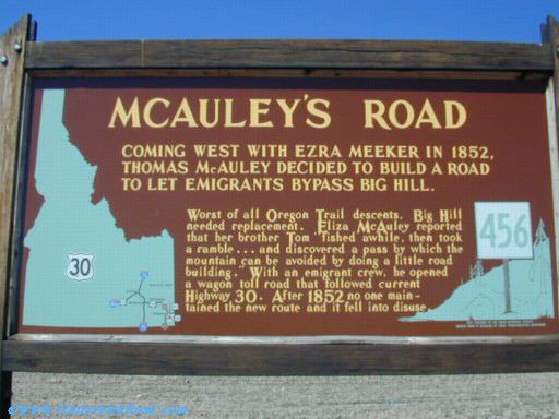
McAuley’s Cut-Off |
Coming west with Ezra Meeker in 1852, Thomas McAuley decided to build a road to let emigrants bypass Big Hill considered the worst of all Oregon Trail descents. McAuley’s route went through a pass by which the mountain was avoided. It follows along current Highway 30. An historical marker is located along U.S. Route 30 at about N42.235050° W111.233073°. |
|
||||||||||||||||||||||||||||||||||||||||||||||||||
|
Meeteetsee Trail |
This old stage and freight road, founded in 1881 by the army, headed out of Red Lodge, Montana south to Meeteetsee, Wyoming. It is about 100 miles long. |
|
||||||||||||||||||||||||||||||||||||||||||||||||||
|
Montana Trail |
The Montana Trail was wagon road that served gold rush towns such as Bannack, Virginia City and later Helena, Montana during the Montana gold rush era of the 1860s and 1870s. It branched from the Oregon Trail in southeastern Idaho near Fort Hall and ran north through eastern Idaho along an ancient Native-American path that is now U.S. Route 91 to Great Falls where it continued on U.S. Route 87 to Fort Benton, Montana on the Missouri River. |
|
||||||||||||||||||||||||||||||||||||||||||||||||||
|
Mormon Trail |
The route that the Mormons followed to Utah. It paralleled the Oregon Trail in parts, but traversed the Rockies by the South Pass. Aka. Emigrant Trail |
|
||||||||||||||||||||||||||||||||||||||||||||||||||
|
Mormon Wagon Road |
Also called the Old Arizona Road this route ran between the Mormon settlements in Arizona and Salt Lake City. It followed the route of the Old Spanish Trail between St. George, Utah and Salt Lake City. This segment would later become part of the Salt Lake City to Los Angeles Wagon Road. A southern extension of this route was known as the Honeymoon Trail. |
|
||||||||||||||||||||||||||||||||||||||||||||||||||
|
Montgomery and Gertrude Wagon Road Route 8M6; Info. Link (1); Map (1); Images (1) |
This 1881 traveled via Hoosier Pass from Montgomery and up the Platte River to the Gertrude mine, near Hamilton in Park County*. It is possible that this troad was never accomplished as there is no evidence of a trail between these two place. § * Hamilton is no longer in existence. |
|
||||||||||||||||||||||||||||||||||||||||||||||||||
|
Mosquito Pass Wagon Road |
A road chartered in 1878, also called Mosquito Pass Toll Road, commenced from the forks of Mosquito Creek above the town of Park City in Park County, then west and over the Mosquito Range through Mosquito Pass and down west side of range to Evans Gulch and then Oro City. From 1879 to 1880 four major stage and freight lines operated over the road. § |
|
||||||||||||||||||||||||||||||||||||||||||||||||||
|
|
|
|||||||||||||||||||||||||||||||||||||||||||||||||||
N
|
Name (Links to Resources) |
Places of Termination |
Descriptive Information |
|
||||||||||||||||||||||||||||||||||||||||||||||||
|
Nevada Emigrant Trail Route
8N2; Info. Link (1); Map (1); Images
(1) |
near Ocala, NV |
A name for that
part of the California Trail through Nevada east of the parting of the
Truckee and Carson Routes near Ocala, Nevada to a junction with the Oregon Trail
in Idaho. This part of the trail to California covered approximately 425
miles. It has been estimated that some 200,000 people took this arduous route
to California through Nevada between 1840 and 1860, the greatest peacetime
migration in history. By comparison, 53,000 people traveled the Oregon Trail |
|
|||||||||||||||||||||||||||||||||||||||||||||||||
|
Nez Perce Trail |
The Nez Perce (Nimíipuu or Nee-Me-Poo) National Historic Trail commemorates the 1877 flight of the Nez Perce from their homelands while pursued by U.S. Army. Nearly 750 men, women, and children and twice that many horses travelled over 1,170 miles through the mountains, on a trip that lasted from June to October of 1877. This route was used in its entirety only once; however, component trails and roads that made up the route bore generations of use prior to and after the event. |
|
||||||||||||||||||||||||||||||||||||||||||||||||||
|
|
|
|||||||||||||||||||||||||||||||||||||||||||||||||||
O
|
Name (Links to Resources) |
Places of Termination |
Descriptive Information |
|
||||||||||||||||||||||||||||||||||||||||||||||||
|
Old Arizona Road |
|
See Mormon Wagon Road |
|
|||||||||||||||||||||||||||||||||||||||||||||||||
|
Oregon Trail (ID) Route 8O1; Info. Link (1); Maps (1); Images (1);
|
The eastern terminus of the Oregon Trail is located along U.S. Route 30 at N42.213507° W111.047323°. The main route runs north through Soda Springs to Pocatello then west along the south side of the Snake River to Raft River Crossing where the California Trail branches to the south. At the Three Island Crossing the Oregon Trail divides The main route continued northwest to Boise and crossed into Oregon near Nyssa in Malheur County at approximately N43.821716° W117.022051°. The Southern Route ran south of the Snake River to where it joins the main trail in Oregon near Nyssa. |
|
||||||||||||||||||||||||||||||||||||||||||||||||||
|
Oregon Trail (South Alternate) |
Starting in about 1848 the South Alternate of Oregon Trail (also called the Snake River Cutoff) was developed as a spur off the main trail. It bypassed the Three Island Crossing and continued traveling down the south side of the Snake River. It rejoined the trail near present day Nyssa in Malheur County Oregon. Today's Idaho State Route 78 roughly follows the path of the South Alternate route of the Oregon Trail. |
|
||||||||||||||||||||||||||||||||||||||||||||||||||
|
Oregon Trail (WY) |
The eastern terminus of the Oregon Trail is located about 2.5 miles south of Henry, Nebraska at N41.962624° W104.052732°. From there it follows the North Platte River to Fort Laramie continues up the North Platte River eventually veering to the south, into the Sweetwater River Valley, which heads almost due west. The trail crosses over the Continental Divide at South Pass, Wyoming. From there the trail continues southwest to the ferry crossing of the Green River and then on to Fort Bridger at the Blacks Fork of the Green River. From Fort Bridger, the Oregon trail, comprising several variants, veered northwest over the Bear River Divide and descended to the Bear River Valley to its western terminus located along U.S. Route 30 at N42.213507° W111.047323°. at the present Wyoming–Idaho border. |
|
||||||||||||||||||||||||||||||||||||||||||||||||||
|
Overland Trail |
Due to Indian uprisings in the 1860’s the Oregon Trail through central Wyoming was relocated to the south, to a route which had been known, in part, as the Cherokee Trail. It became the only emigrant route on which the US Government would allow travel, and consequently was the principal corridor to the west from 1862 to 1868. |
|
||||||||||||||||||||||||||||||||||||||||||||||||||
|
Overland-Cherokee Trail |
|
See Cherokee Trail |
|
|||||||||||||||||||||||||||||||||||||||||||||||||
|
|
|
|||||||||||||||||||||||||||||||||||||||||||||||||||
P
|
Name (Links to Resources) |
Places of Termination |
Descriptive Information |
|
||||||||||||||||||||||||||||||||||||||||||||||||
|
Park Range Road Route 8P1; Info. Link (1); Map (1); Images (1) |
Route established about 1878 and starting at about 4 miles douth of Malta the western part in Lake County follows along present day CR 7 from where it departs from U.S. Route 24 at Empire Gulch. It crosses the Continental Divide at Weston Pass between Lake and Park Counties, then down CR 22 along the South Fork of the South Platte River to present day to a Salt Works near US Rt. 285 about 10 miles south of Fairplay in Park County. § |
|
||||||||||||||||||||||||||||||||||||||||||||||||||
|
Pitkin and Virginia City (Tincup) Toll Road Route 8P2; Info. Link (1); Map (1); Images (1) |
An 1881 commercial toll road from Pitkin down Willow Creek to Virginia City, now Tincup. Today this route follows along Gunnison County Route 765. § |
|
||||||||||||||||||||||||||||||||||||||||||||||||||
|
Point of Rocks-South Pass Stage Road |
With the completion of the Union Pacific Railroad across southern Wyoming in 1869, a series of stage and freight wagon roads were developed to serve fledgling communities to the north. One of these routes the Point of Rocks-South Pass City Road, was established to serve the boom town of South Pass City that sprang to life following gold discoveries along the upper Sweetwater region in 1867. |
|
||||||||||||||||||||||||||||||||||||||||||||||||||
|
|
|
|||||||||||||||||||||||||||||||||||||||||||||||||||
Q
|
Name (Links to Resources) |
Places of Termination |
Descriptive Information |
|
||||||||||||||||||||||||||||||||||||||||||||||||
|
Route 9X1; Info. Link (1); Map (1); Images (1) |
|
|
|
|||||||||||||||||||||||||||||||||||||||||||||||||
|
|
|
|||||||||||||||||||||||||||||||||||||||||||||||||||
R
|
Name (Links to Resources) |
Places of Termination |
Descriptive Information |
|
||||||||||||||||||||||||||||||||||||||||||||||||
|
Rawlins-Fort Washakie Stage Road |
With the completion of the Union Pacific Railroad across southern Wyoming in 1869, a series of stage and freight wagon roads were developed to serve fledgling communities to the north. One of these routes the Rawlins-Fort Washakie Stage Road was developed to serve the headquarters of the Wind River Indian Reservation. Portions of Highway 287 from Rawlins to Lander parallel the Fort Washakie Road. |
|
||||||||||||||||||||||||||||||||||||||||||||||||||
|
Red Canon Toll Road Route 8R2; Info. Link (1); Map (1); Images (1) |
A circa 1877 route to run from Squaw Creek near its junction with Eagle River, down present day U.S. Route 6 thru the Red Canyon to the present day town of Gypsum. All in Summit County. § |
|
||||||||||||||||||||||||||||||||||||||||||||||||||
|
Red Cliff and Gore Creek Wagon Road Route 8R3; Info. Link (1); Map (1); Images (1) |
This route appears to loosely follow what is now U.S. Route 24 from Redcliff in Eagle County to along the Belden mine Road then northwest to the site of Astor City then down Eagle River to the mouth of Gore Creek at Dowds Junction. § |
|
||||||||||||||||||||||||||||||||||||||||||||||||||
|
Red Mountain and Ashcroft Toll Road Route 8R4; Info. Link (1); Map (1); Images (1) |
This toll road as chartered in 1881 to run from near present day Everett in the southwest corner of Lake County at the confluence from the north and south forks of Lake Creek and running southwest along the South Fork of Lake Creek to Lake Creek or Red Mountain Pass in Chaffee County then west to Ashcroft in Pitkin County. § |
|
||||||||||||||||||||||||||||||||||||||||||||||||||
|
|
|
|||||||||||||||||||||||||||||||||||||||||||||||||||
S
|
Name Links to Resources) |
Places of Termination |
Descriptive Information |
|
||||||||||||||||||||||||||||||||||||||||||||||||
|
Salt Lake Cutoff |
One of the many shortcuts that branched from the California Trail and Oregon Trail |
|
||||||||||||||||||||||||||||||||||||||||||||||||||
|
Seminoe Cutoff |
In 1853, a new route named Seminoe cutoff was established on the southern side of the North Platte River. The Seminoe cutoff split from the main trail at near the 6th crossing of the Sweetwater River at about N42.510910° W108.142130°. It then rejoined to main Oregon Trail on the south side of the Sweetwater River at approximately N42.373710° W108.717477° near Burnt Ranch. The route was used extensively in the 1850s, especially by the Mormon companies. |
|
||||||||||||||||||||||||||||||||||||||||||||||||||
|
Slate Creek Cutoff |
|
See Kinney Cutoff |
|
|||||||||||||||||||||||||||||||||||||||||||||||||
|
Snake River Cutoff |
|
see South Alternate (Oregon Trail) |
|
|||||||||||||||||||||||||||||||||||||||||||||||||
|
South Park, Alma, and Leadville Toll Road Route 8S4; Info. Link (1); Map (1); Images (1) |
1878. From Lechners Coal Bank in South Park, now Fairplay in Park County, west over foot hills of Silver Heels Mountain to Alma, then via Mosquito Gulch, Mosquito Pass, and Evans Gulch to Leadville. § |
|
||||||||||||||||||||||||||||||||||||||||||||||||||
|
South Park, Alma, and Ten Mile Toll Road Route 8S5; Info. Link (1); Map (1); Images (1) |
Originally described in 1879 as “beginning at a point on the line of the Denver South Park & Pacific Railroad near the Eight Mile House and the base of Mount Silverheels.” This place is believed to be near Fairplay at Beaver Creek Rd (Park County Road 655). Running from her to Alma, thence along the Platte to the head then across the range to head of Ten Mile Creek and then to Carbonateville*. § * The site of Carbonateville is near the Lake and Summit County line and may actually be in Summit County. |
|
||||||||||||||||||||||||||||||||||||||||||||||||||
|
South Pass Road |
|
See Lander Road |
|
|||||||||||||||||||||||||||||||||||||||||||||||||
|
Sublette-Greenwood Cutoff |
A part of the Emigrant Trail in Wyoming that was opened in 1844 by Stephens-Townsend-Murphy Party lead by mountaineers Caleb Greenwood and Isaac Hitchcock. This route let to main Oregon Trail, now State Route 28 at approximately N42.286034° W109.056307°. This alternate trail completely bypassed Fort Bridger crossing the Bear River Ridge thus saving about 85 miles and 7 days off the main route. |
|
||||||||||||||||||||||||||||||||||||||||||||||||||
|
Sweetwater and White River Toll Road Route 8S7; Info. Link (1); Map (1); Images (1) |
Company, v. 10, p. 558, June 18, 1885. From the town of Dotsero near the junction of the Eagle River and Grand River* to the mouth of the South Fork of the White River by way of Deep Creek and Sweetwater River and down the South Fork of the White River with branches to Carbonate and Defiance Mining Camp, near Glenwood Springs, at N39.561596° W107.249901°. § * Name changed to Colorado River in 1921 |
|
||||||||||||||||||||||||||||||||||||||||||||||||||
|
|
|
|||||||||||||||||||||||||||||||||||||||||||||||||||
T
|
Name (Links to Resources) |
Places of Termination |
Descriptive Information |
|
||||||||||||||||||||||||||||||||||||||||||||||||
|
Ten Mile Wagon Road Route 8T1; Info. Link (1); Map (1); Images (1) |
This road was created to transport freight, passengers, and public mail and to erect toll gates and to collect tolls The route probably followed along present-day U.S. Route 6 to Wheeler Junction were it connected to State Route 91 south to Carbonateville*. § * The site of Carbonateville is near the Lake and Summit County line and may actually be in Summit County. |
|
||||||||||||||||||||||||||||||||||||||||||||||||||
|
Tennessee Pass and Red Cliff Wagon Road Route 8T2; Info. Link (1); Map (1); Images (1) |
This 1883 wagon road ran from Tennessee Pass near the border of Lake and Eagle counties near N39.355602° W106.313630° by way of Taylor, westerly from Little Piney Creek to Mitchells then down Little Piney Creek to Eagle City along the line of the Eagle City and Leadville Toll Road. Then across Eagle Park and down Homestake Creek to the mouth of said creek, then up the Eagle Creek to Red Cliff along the line of the Eagle River Toll Road. § |
|
||||||||||||||||||||||||||||||||||||||||||||||||||
|
Trapper’s Trail |
As the nearest customs officials were in Santa Fe, Taos became a commercial center for outfitting the trappers and for trading in their pelts. The route over Sangre de Cristo Pass became known as the Trappers Trail and fingers of it extended northward into Wyoming. The Trapper’s Trail intersects with the Cherokee Trail between Pueblo and Denver Colorado. |
|
||||||||||||||||||||||||||||||||||||||||||||||||||
|
Truckee Route in Nevada |
near Ocala, Churchhill Co., NV
|
This major branch of the California Trail was established in 1844 by the Stephens-Townsend-Murphy Party to travel over the Sierra Nevada Mountains. In 1845, Caleb Greenwood and his three sons developed a new route that by-passed Truckee River Canyon and crossed the Sierra crest through 7,000 feet (2,100 m) Donner Pass. Johnson’s Ranch was the last stop on the Emigrant Trail to Sutter's Fort. The Nevada segment of the Truckee Route enters California near Interstate 80, Verdi, Sierra County, California. See also California Trail in Nevada. |
|
|||||||||||||||||||||||||||||||||||||||||||||||||
|
Twin Lakes and Arkansas Toll Road Route 8T5; Info. Link (1); Map (1); Images (1) |
1881. It is probable that this road is now Colorado State Route 82. If so it ran from the station on the Denver & Rio Grande Railroad known as the Twin Lakes Station, near present day Balltown at about N39.073992° W106.278744°. Then west by a bridge across the Arkansas River then up the bluffs on the west bank of the Arkansas River to the valley of Lake Creek, then along the valley of Lake Creek to the Lower Twin Lake to the village of Twin Lakes between the two lakes. § |
|
||||||||||||||||||||||||||||||||||||||||||||||||||
|
Twin Lakes, Roaring Forks, & Grand River Rd. Route 8T6; Info. Link (1); Map (1); Images (1) |
This 1879 toll road is now Colorado SR 82 traveled from Twin Lakes in Lake County. It traveled up Lake Creek to the Forks of said Creek near present day Everett thence up the north fork of said Creek to the Mountain Boy Gulch, and up said Mountain Boy Gulch and over Independence Pass thence down Independence Gulch to the Roaring Fork Creek, thence down Roaring Fork Creek to the Grand River* at present day Glenwood Springs. § * Name changed to Colorado River in 1921 |
|
||||||||||||||||||||||||||||||||||||||||||||||||||
|
|
|
|||||||||||||||||||||||||||||||||||||||||||||||||||
U
|
Name (Links to Resources) |
Places of Termination |
Descriptive Information |
|
||||||||||||||||||||||||||||||||||||||||||||||||
|
Ute Pass Trail |
This Native-American trail was first utilized to travel between the plains into the Rocky Mountains. This same wilderness road was followed by mountain men, explorers, prospectors, freight wagons, and the Colorado Midland Railroad, and is now the route of a modern highway U.S. 24.
|
|
||||||||||||||||||||||||||||||||||||||||||||||||||
|
|
|
|||||||||||||||||||||||||||||||||||||||||||||||||||
V
|
Name (Links to Resources) |
Places of Termination |
Descriptive Information |
|
||||||||||||||||||||||||||||||||||||||||||||||||
|
Virginia and Roaring Fork Toll Road Route 8V1; Info. Link (1); Map (1); Images (1) |
Company, v. 2, p. 276, Mar. 5, 1880. From Virginia City, now Tincup, in Gunnison County, then to Hillerton in Gunnison County then to a point on the Cottonwood Toll Road near Willow Creek, then through Taylor Park along the line of the Old Ute Trail then to Roaring Forks (through later Aspen), north of Gunnison County. § |
|
||||||||||||||||||||||||||||||||||||||||||||||||||
|
|
|
|||||||||||||||||||||||||||||||||||||||||||||||||||
W
|
Name (Links to Resources) |
Places of Termination |
Descriptive Information |
|
||||||||||||||||||||||||||||||||||||||||||||||||
|
Whitman Trail |
Parallels the Oregon Trail until it joins with it at Fort Laramie. |
|
||||||||||||||||||||||||||||||||||||||||||||||||||
|
|
|
|||||||||||||||||||||||||||||||||||||||||||||||||||
X
|
Name (Links to Resources) |
Places of Termination |
Descriptive Information |
|
||||||||||||||||||||||||||||||||||||||||||||||||
|
Route 9X1; Info. Link (1); Map (1); Images (1) |
|
|
||||||||||||||||||||||||||||||||||||||||||||||||||
|
|
|
|||||||||||||||||||||||||||||||||||||||||||||||||||
Y
|
Name (Links to Resources) |
Places of Termination |
Descriptive Information |
|
||||||||||||||||||||||||||||||||||||||||||||||||
|
||||||||||||||||||||||||||||||||||||||||||||||||||||
|
||||||||||||||||||||||||||||||||||||||||||||||||||||
|
|
|
|||||||||||||||||||||||||||||||||||||||||||||||||||
Z
|
Name (Links to Resources) |
Places of Termination |
Descriptive Information |
|
||||||||||||||||||||||||||||||||||||||||||||||||
|
Route 9X1; Info. Link (1); Map (1); Images (1) |
|
|||||||||||||||||||||||||||||||||||||||||||||||||||
|
|
|
|||||||||||||||||||||||||||||||||||||||||||||||||||
Image Gallery
IMAGE GALLERIES The following links will take you to images and photographs that are of general interest to a variety of historic American roads, trails and migration routes. They may provide the family historian with additional information which may aid in the understanding of this topic as well as our ancestors past lives. |
|
|||||||||||||||||||||||||||||||||||||||||||||||||||
|
Images of Historic Trails and Roads in the Rocky Mountain States |
|
|||||||||||||||||||||||||||||||||||||||||||||||||||
|
· Images of Historic Trails and Roads in Colorado |
· Images of Historic Trails and Roads in Nevada |
|
||||||||||||||||||||||||||||||||||||||||||||||||||
|
Use the power of Google™ to find more interesting images about this topic. This button will link you to the Google Images Search page. Enter the topic you are searching in the box and click “Search Images”. At the “Images” display page you will see the image, as well as the website of which it is associated. |
|
|||||||||||||||||||||||||||||||||||||||||||||||||||
|
|
|
|||||||||||||||||||||||||||||||||||||||||||||||||||
Inyernet resources
|
|
|||||||||||||||||||||||||||||||||||||||||||||||||||
|
The Google Search Engine button and following web sites may provide you with additional information to assist your research about this topic. |
|
|||||||||||||||||||||||||||||||||||||||||||||||||||
|
General Resources |
|
|||||||||||||||||||||||||||||||||||||||||||||||||||
|
· A Listing of Historic Roads in America · Historical U.S. roads and trails - Wikipedia · U.S. Historical Maps - Perry-Castañeda Collection · Early American Roads and Trails · US Migration Trails and Roads – Family Search Wiki · American Migration Trails: Eastern United States · Historic trails & roads in the U.S.A. by state - Wikipedia |
· American Migration Fact Sheets · Map guide to American migration routes,1735-1815 · Links to Migration Routes Websites · Westward Expansion: Trails West · Migration Message Boards – Ancestry.com · The African-American Migration Experience · United States Migration (Internal) – Family Search Wiki · Map of U.S. Trails – Geocities.com · Migration Routes, Roads & Trails · Ancient Traces and Roads - Waymarking.com |
|
||||||||||||||||||||||||||||||||||||||||||||||||||
|
Topic Specific Resources |
|
|||||||||||||||||||||||||||||||||||||||||||||||||||
|
· Montana Emigration & Immigration - Family Search Wiki · Colorado Emigration & Migration - Family Search Wiki · Nevada Emigration & Migration Family Search Wiki · Idaho Emigration & Immigration - Family Search Wiki · Wyoming Emigration & Immigration - Family Search Wiki · Utah Emigration & Migration - Family Search Wiki · Historic trails and roads in Montana - Wikipedia · Historic trails and roads in Colorado - Wikipedia · Historic trails and roads in Nevada - Wikipedia · Historic trails and roads in Idaho – Wikipedia · Historic trails and roads in Wyoming - Wikipedia |
· Historic trails and roads in Utah - Wikipedia · Nevada Historic Highways And Trails Maps · Utah State History: Markers & Monuments · Historic Trails of the Old West · National Historic Trails Interpretive Ctr. - Wyoming |
|
||||||||||||||||||||||||||||||||||||||||||||||||||
|
Additional Resources at our Online Reference Library |
|
|||||||||||||||||||||||||||||||||||||||||||||||||||
|
The following Link will take you to our library of genealogy reference books. Here you will find books about historic American roads, trails, and paths. In addition, there are texts that pertain to ethnic and religion groups, history, geography as well as other books that will assist you with your research. This Link will take you to our collections of reference books |
|
|||||||||||||||||||||||||||||||||||||||||||||||||||
|
|
|
|||||||||||||||||||||||||||||||||||||||||||||||||||
About
This Webpage
About This Webpage |
|
|||||||||||||||||||||||||||||||||||||||||||||||||||
|
CONTACT INFORMATION
We do like to hear from others who are
researching the same people and surnames. We need your help to keep growing! So please Email photos, stories, and other appropriate information
about this topic. RULES OF USE We only ask that if you have a personal website please create a link to our Home Page. This webpage was last updated on 12 December 2015 ©copyright 2013-15 |
|
|||||||||||||||||||||||||||||||||||||||||||||||||||
|
|
|
|
|
|||||||||||||||||||||||||||||||||||||||||||||||||


.JPG)
.jpg)
.jpg)
.JPG)
.JPG)
.jpg)
.jpg)
.JPG)
.jpg)
.jpg)
.jpg)
.JPG)
.jpg)
.jpg)
.jpg)
.jpg)
.JPG)
.jpg)