|
Ref # |
Cemetery Name |
GPS Mapping |
Aerial View |
Road Map |
Photos |
Text |
Find a Grave
(1) |
Survey
Book #
(2)
|
Survey Book #
(3)
|
Location |
| |
|
|
|
|
|
|
|
|
|
|
|
35-178 |
Allston Cemetery (old) |
Original cemetery location is now under Lake Thurmond |
|
|
P |
|
|
|
|
245 graves reinterred at 35-179 Allston
(new) |
|
35-179 |
Allston Cemetery (new) |
Can't locate cemetery |
|
|
P |
|
|
|
|
245 graves reinterred |
|
35-001 |
Anderson-Belcher Family |
n33
56.521 , w82 08.290 |
A |
M |
P |
|
|
|
|
4500 ft W of Rt 67, S of Long Cane Rd, McCormick |
|
35-002 |
Asbury
Methodist |
N33
39.017 , W82 09.500 |
A |
M |
P |
T |
|
35-B1-P001
|
|
GPS-JH, 200 ft W of Rt 28, S of
33-342, Clarks Hill |
|
35-215 |
Ashbury Mission |
Can't locate cemetery |
|
|
P |
|
|
|
|
From downtown McCormick, take SC-28 SE. Stay on SC-28 for about
2 miles after US-221 parts to the SW. At this point S-33-200
makes a small loop to the SW. S-33-200 no longer appears to be
road and is no longer passable; the southern portion of the road
is blocked by a guard-rail and the northern portion appears to
be a private driveway. The church and cemetery are supposedly
located at the southwestern-most portion of this road.
|
|
35-003 |
Badwell Family
|
n33
55.583 , w82 22.683 |
A |
M |
P1 |
T
T
T
T |
|
35-B1-P002
|
|
Owners: Joseph Allston, Rev. Jean Gilbert & James Petigru,
Badwell Cemetery Rd, N of
Huguenot Pkw,McCormick, original plantation lands were located off SC 28 on SC
Secondary Road 61, about 3m N of
McCormick |
|
35-004 |
Bailey
Bethel AME Methodist (N) |
n33
57.550 , w82 06.050 |
A |
M |
P |
|
|
35-B1-P000
|
35-CG-BB
|
Long Cane Rd & Scotts Ferry
Rd, Troy |
|
35-009 |
Barker-Boyd-Powell Family |
N34
02.683 , W82 31.567 |
A |
M |
P1 |
T |
|
|
|
GPS-JH, Calhoun Mill Rd, E
of McAllister Chapel Rd,
Calhoun Falls |
|
35-180 |
Bath Plantation Family
+ Slave Cemetery ?
|
Can't locate cemetery |
|
|
P |
|
|
|
|
Owner: John C. Calhoun,
1m from Savannah River, adjacent to Cherry Hill
Plantation |
|
35-081 |
Bethany Baptist
(est. 1809) (N) |
n33
55.467 , w82 11.150 |
A |
M |
P |
T |
|
|
|
US 378, E of Church,
McCormick, |
|
35-005 |
Bethany Baptist (est. 1850) (N) |
n33
55.417 , w82 11.200 |
A |
M |
P1 |
T |
|
35-B1-P004
|
35-CG-BM
|
W of church, US378 & Willis
Rd, McCormick |
|
35-006 |
Bethany Baptist (N) |
n33
38.033 , w82 08.817 |
A |
M |
P |
|
|
35-B1-P010
|
35-GC-BCH
|
Rt 28, S of Woodhaven Rd,
Clarks Hill |
|
35-007 |
Bethlehem Baptist (1821) |
n33
40.133 , w82 10.367 |
A |
M |
P1 |
T |
|
35-B1-P013
|
|
Rt 28, S of US 221, Clarks
Hill |
|
35-008 |
Bordeaux French Protestant |
n33
55.570 , w82 25.286 |
A |
M |
P |
T
T
T |
|
35-B1-P014 |
|
33-110 &
33-7, McCormick |
|
35-182 |
Bradley Plantation Family
+ Slave Cemetery ?
|
Can't locate cemetery |
|
|
P |
|
|
|
|
Vienna Rd near Little Road, Route 823 |
|
35-010 |
Bracknell-Roundtree Family |
N33
56.439 , W82 14.357 |
A
|
M
|
P |
T |
|
35-B1-P015
|
|
GPS-JH, 1000 ft S of Old
Post Rd, E of US 221,McCormick |
|
35-011 |
Brough Family |
n34
01.467 , w82 32.217 |
A |
M |
P |
T |
|
35-B1-P015
|
|
1250 ft E of Newton Rd, S of
McAllister Chapel Rd,Mt Carmel |
|
35-012 |
Buffalo Baptist |
n33
56.933 , w82 22.350 |
A |
M |
P1 |
T |
|
35-B1-P016
|
|
Rt 28 & Kennedy Rd,
McCormick |
|
35-183 |
Bussey Family (old) |
Original cemetery location is now under Lake Thurmond |
|
|
P |
|
|
|
|
34 graves reinterred at 35-179 Allston Cemetery |
|
35-013 |
Burkhalter-Gilchrist-Kilcrease Family |
N33 49.277 , W82 09.218 |
A |
M |
P |
T |
|
35-B1-P020
|
|
GPS-JH, 33-138 Key Rd, near Rehoboth
Church |
|
35-014 |
Cade Episcopal Methodist |
N33 58.408 , W82 28.012
|
A |
M |
P |
T |
|
35-B1-P020
|
|
aka Saint
Stephen's Episcopal
GPS-JH, location: Turn right
at Esso Station, thenleft into Hemminger's
driveway, continue straight
through 2 rock columns to gravesites.
|
|
35-015 |
Calhoun Family |
Can't locate cemetery
|
|
|
P1 |
T |
|
35-B1-P020
|
|
33-134, N of Rt 823, Calhoun
Falls, location: Go
north from McCormick on Highway 28 to road S-33-
37. Follow S-33-37 to road S-33-19. Follow S-33-19 to road S-33-40
and turn right. Go approximately 1.5
miles to Highway SC 823. Turn left and travel
approximately 0.1 mile to road S-33-134. Cemetery
located on high bank at first steep cut in road directly
under power line on right side of road. River runs
parallel to this road and old Calhoun Mill is located on
opposite bank of this river, 2 graves. |
|
35-016 |
Callaham's Mill Church |
n33
47.133 , w82 13.050 |
A |
M |
P |
T |
|
35-B1-P021 |
|
aka 35-085 Parkville Baptist ?
location: On Stevens Creek, near Parksville |
|
35-216 |
Canfield Cemetery |
n33 52.998 , w82 14.700 |
A |
M |
P |
|
|
|
|
aka 35-041 Henderson |
|
35-017 |
Cartledge-Cunningham Family |
Can't locate cemetery
|
|
|
P |
T |
|
35-B1-P021 |
|
Dirt road E of Parksville |
|
35-185 |
Cedar Hill Plantation Family
+ Slave Cemetery ?
|
Can't locate cemetery |
|
|
P |
|
|
|
|
aka 35-015 Calhoun ?
Owners: Joseph Calhoun, Thomas, Petrigru,
Rt 828, Little River
|
|
35-019 |
Cedar Spring Baptist (N) |
n33 51.460 , w82 11.610 |
A |
M |
P |
|
|
|
35-CG-CS
|
Rt 283, E of Upper Mill Rd. Plum Branch |
|
35-018 |
Cedar Springs Road Cemetery (N) |
n33
48.617 , w82 09.467 |
A |
M |
P |
|
|
|
35-CG-OCS
|
W of Cedar Springs Rd, W of Key Rd, Modoc |
|
35-020 |
Chapel Holiness Church |
n34
02.333 , w82 21.400 |
A |
M |
P |
|
|
|
|
1200 ft E of Long Cane Rd, 1.6 mile S of Wilson Rd,
Abbeville |
|
35-049 |
Cherokee Indian Long Cane Creek 23 Settler Massacre Cemetery |
n33
59.760 , w82 20.400 |
A |
M |
P1 |
T
T |
|
|
|
SC Sec. Rd. 141, Troy vicinity,
location: On Sec. Rd. S-33-36, 2 miles west of
Troy, .25 mile west of Long Cane Creek, 1-Feb-1760 |
|
35-219 |
Cherokee Indian Troy Area
Settler Massacre Cemetery |
n33
59.733 , w82 20.367 |
A |
M |
P1 |
T
T |
|
35-B1-P030 |
|
150 settler graves, 33-141, S of 33-117, W of Rt
10, Troy |
|
35-186 |
Cherry Hill Plantation Family
+ ~200 Slave Cemetery
|
Can't locate cemetery |
|
|
P |
T |
|
|
|
Owners: George McDuffie
& Ezekiel Noble, 1m from Willington Academy, (Old Abbeville County ?)
|
|
35-021 |
Chisholm Family |
n34
01.700 , w82 22.117 |
A |
M |
P |
|
|
|
|
2000 ft w of Long Cane Rd, s
of Glover Chapel, Abbeville |
|
35-022 |
Cook Family |
Can't locate cemetery
|
|
|
P |
T |
|
35-B1-P021 |
|
US 221 on right McCormick to
Greenwood, behind Sullivan home |
|
35-187 |
Cotton Level Plantation Family
+ ~125
Slave Cemetery ? |
Can't locate cemetery |
|
|
P |
|
|
|
|
Owners: Sam, Tom, Eliza & William Perrin,
On Hard Labor Creek, near Calabash Ck, (Old Abbeville County ?) |
|
35-188 |
Creswell Family |
Can't locate cemetery |
|
|
P1 |
T |
|
|
|
location: Go north from McCormick on Highway
28 past Buffalo Baptist Church to dirt road marked Troy---, Turn
right on this road and travel approximately 3.7
miles to another dirt road marked 565C Dead End.
Turn right on this road and travel approximately .7
mile and find cemetery on left, 20 graves |
|
35-023 |
Creswell Family, Kittie |
Can't locate cemetery |
|
|
P |
T |
|
35-B1-P021 |
|
3.7m E of Rt 28 on rd
565C, N of McCormick, location: Go north on Hwy. 10. Turn left onto road S-
33-64,
turn right across railroad and go just past
water pond
on road S-33-82 approx. 3/10 mile to
house place with one large oak on left and other
house place with five large oaks on right. Walk past house place on
right, bear approx. 40 degrees to left
of house for approx. 1/2 mile. Follow old road bed
approx. 200 yards. Cemetery is on right of old road
bed. |
|
35-024 |
Davidson-McComb Family |
n34
00.443 , w82 19.861 |
A |
M |
P1 |
T |
|
35-B1-P022 |
|
Forest Rd F2274, 3000 ft W
of Long Cane Rd, Troy |
|
35-025 |
de la Howe, John (grave) |
n33
56.148 , w82 23.838 |
A
|
M |
P1 |
T |
|
35-B1-P023 |
|
Tomb Rd, off Branch Dr, S of
Rt 81, McCormick |
|
35-026 |
Deason
Family |
n33 53.378 , w82 18.154 |
A
|
M |
P |
T |
|
35-B1-P022 |
|
Deason Cemetery Rd, S of US
378, McCormick |
|
35-027 |
Dillashaw Family |
n33 53.450 , w82 21.534 |
A |
M |
P |
T |
|
35-B1-P023 |
|
N of US 378 in Baker State
Park, McCormick |
|
35-189 |
Dornville Plantation Family
+ Slave Cemetery ?
|
Can't locate cemetery |
|
|
P |
|
|
|
|
Owner: Billy
Dorn, Vicinity of the Hard Labor Creek , 600 acres |
|
35-028 |
DuBose Episcopal Methodist
(old) |
N33 57.044 , W82 28.735 |
A |
|
P |
T |
|
35-B1-P024 |
|
aka Saint Stephen's
Episcopal (old)
GPS-JH, 0.75m past
Willington Cemetery, Willington,
location: Approximately 3/4 mile past Willington
Cemetery on old Willington road. Right side of road
approx. 150 yards. Rusty wire fence with metal frame
wire gate |
|
35-190 |
Eden Hall Plantation Family
+ Slave Cemetery ?
|
Can't locate cemetery |
|
|
P |
|
|
|
|
Owners: Elliott Davis, Ebbie
Greer, Frank Greer,
John Wardlaw & Ann Hearst
US 221 at Road 24 |
|
35-029 |
Edmonds Family |
n33
51.827 , w82 21.605 |
A |
M |
P |
T
T |
|
35-B1-P025 |
|
Edmonds Cemetery Rd, E of
Holiday Rd, McCormick, |
|
35-030 |
Freeland Family |
n33
51.440 , w82 15.255 ???
N33 54.399 , W82 09.175 ??? |
A
A |
M
M |
P1 |
T |
|
35-B1-P025 |
|
GPS-JH, N of 33-58, .5 miles N of
Plum Branch |
|
35-031 |
Fuller Family |
n33
54.137 , w82 11.583 |
A |
M |
P |
T |
|
35-B1-P026 |
|
1 mile E of Liberty Hill Rd,
on dirt Rd, Plum Branch |
| |
Gary Family (N) |
Can't locate cemetery |
|
|
P |
|
|
|
35-CG-G |
Close to Glovers Chapel Baptist |
| |
Gilchrist Family (N) |
Can't locate cemetery |
|
|
P |
|
|
|
35-CG-GF |
Parksville, behind Lebanon Baptist |
|
35-032 |
Glasgow Family |
N34 01.817 , W82 23.640
|
A |
|
P |
T |
|
|
|
GPS-JH, location: Go north on
Abbeville Highway.
Turn right at Indian Massacre-Covered-Bridge sign
and travel approx. 150 yards.
Turn right on Sawmill Road
for approx. 200 yards. Cemetery is on left of Sawmill
Road. |
| |
Glovers Chapel Baptist (N) |
Can't locate cemetery |
|
|
P |
|
|
|
35-CG-GC |
Off 28, on S-33-36 Long Cane Rd |
|
35-033 |
Glover's Chapel Baptist
(N) |
n34
02.117 , w82 21.667 |
A |
M |
Pr
* |
|
|
|
35-CG-GC |
Long Cane Rd, S of Wilson
Rd |
|
35-191 |
Goodwill Family |
Can't locate cemetery |
|
|
|
|
|
|
|
|
|
35-034 |
Goodwin Family |
N33 58.095 , W82 21.445 |
|
|
P1 |
T |
|
35-B1-P026 |
|
GPS-JH, location: Go north
from McCormick on Highway 28 past Buffalo Baptist Church to dirt road
marked Troy---. Turn right on this road and travel
approximately 2 miles to road 570 (old firebreak
road). Turn right on road 570 and travel approximately
.1 mile. Watch for concrete drain box in left ditch.
Cemetery is located on steep
hill on left of old road
bed beyond this drain box. |
|
35-035 |
Green
Olive AME Methodist (N) |
n33
58.033 , w82 30.067 |
A |
M |
P |
|
|
|
35-CG-GO |
50 ft W of Turman Rd, 1 mile
S of Rt 81, McCormick |
|
35-192 |
Grove Pine Cemetery |
Can't locate cemetery |
|
|
P |
|
|
|
|
|
|
35-217 |
Grover Chapel |
Can't locate cemetery |
|
|
P |
|
|
|
|
|
|
35-036 |
Guillebeau Family
|
n33 56.804 , w82 26.585 |
A
|
M |
P1 |
T
T
T |
|
35-B1-P026 |
|
Guillebeaux Cemetery Rd, S
of Moss Ave (33-196) McCormick,
|
|
35-037 |
Guthrie Family |
N33 58.686 , W82 28.481
|
A |
|
P |
T |
|
35-B1-P027 |
|
GPS-JH, location: Go
north from McCormick through
Willington. Turn right approx. 1 1/4 miles north of
Willington on dirt road across from small church.
Follow this road approx. 1
mile to old house on left.
Turn right across field
here. Cemetery located on hill
in edge of woods. |
|
35-038 |
Harper's Chapel Church of God (N) |
n34
00.033 , w82 30.717 |
A |
M |
P1 |
|
|
|
35-CG-HC |
Fort Charlotte Rd, W of Rt
81, Mt. Carmel |
|
35-172 |
Harris-Wideman-Wilks Family |
n33 59.683 , w82 22.433 |
A |
M |
P1 |
|
|
35-B1-P108 |
|
33-216, W of 33-117, Troy |
|
35-039 |
Harrison Family |
n33
57.090 , w82 06.396 |
A |
M |
P |
T |
|
35-B1-P028 |
|
2000 ft W of Scotts Ferry
Rd, S of Long Cane Rd,
Troy |
|
35-040 |
Hayes Family |
N33 56.200 , W82 23.459
|
A |
M |
P |
T |
|
35-B1-P028 |
|
GPS-JH, location: Go to de la Howe.
Turn left at de la Howe Tomb sign. Turn left at first road past power
line. Follow this road to old house place with pecan
and cedar
trees. From here you must walk,
following old road bed east north east approximately 1
1/2 miles to cemetery. |
|
35-193 |
Hays Family (old) |
Can't locate cemetery |
|
|
P |
|
|
|
|
|
|
35-041 |
Henderson Family |
n33 53.036 , w82 14.657 |
A |
M |
P1 |
T |
|
35-B1-P028 |
|
aka 35-216 Canfield
200 ft
E of New Hope Rd, N of Whitetown Rd,
McCormick |
|
35-042 |
Holy
Rock Episcopal Church (N) |
n33
56.850 , w82 28.595 |
A |
M |
P |
|
|
|
35-CG-HR |
Willington Academy Rd, E of
Leroys Ferry Rd, McCormick |
|
35-043 |
Holy Springs Baptist (N) |
n33
57.190 , w82 22.050 |
A |
M |
P |
|
|
|
35-CG-HS |
|
|
35-044 |
Hopewell Baptist (old) (N) |
n33
36.550 , w82 07.117 |
A |
M |
P |
|
|
35-B1-P029 |
35-CG-OHW |
Hopewell Church Rd, E of Rt
28, Clarks Hill |
|
35-045 |
Hopewell Cemetery (old) |
n33
37.467 , w82 08.267 |
A |
M |
P1 ?
P2 ? |
T |
|
|
|
1200 ft W of Rt 28 &
Woodland Rd, Clarks Hill |
|
35-194 |
Hopewell Baptist (old) |
N3 02.365 , W82 25.110 ? |
A ? |
|
P1 |
|
|
|
|
GPS-JH
1. From the intersection of SC Highway 28 and US378 in McCormick, go 11.4 miles North on SC Highway 28.
2. Turn left on S-33-19, go 0.3 miles West. (Just before S-33-19, there
will be a sign on Highway 28 saying: Mt. Carmel 7 miles.)
3. Turn right on S-33-81, go 0.5 miles North. (You will pass the
Old Hopewell Church,
which resembles a barn, on your right.)
4. Turn left on S-33-38, go 1.0 miles West. (This is a dirt - and only
dirt - road. You will be 400 feet East of where the road crosses Lee
Creek. At this point, you will have to park your vehicle; you should park
30 feet before (in front of) a "narrow bridge" sign.)
5. On your right (North), you will see an abandoned, primitive roadbed.
A rusty cable crosses this road, blocking vehicular access. Walk 500
feet (180 steps) North along this roadbed to the cemetery. The cemetery is
surrounded by a
wire fence which is
in good repair, although the cemetery itself is overgrown. |
|
35-046 |
Hopewell Presbyterian |
n34
02.350 , w82 25.100 |
A |
M |
P |
T |
|
|
|
600 ft N of Old Charleston
Rd, e of Tate Rd,Troy |
|
35-047 |
Hosannah Baptist (N) |
n33
42.580 , w82 12.000 |
A |
M |
P1 |
|
|
|
35-GC-HOS |
US 221, S of Rt 23, Modoc |
|
35-140 |
Hosannah Baptist (N) |
n33
53.260 , w82 23.610 |
A |
M |
P |
|
|
|
35-CG-HLS |
E of 33-7 Resort Dr, 1.4m N
of 378, McCormick |
|
35-048 |
Houston Family |
N34 01.592 , W82 29.013 |
A |
|
P |
T |
|
35-B1-P029 |
|
GPS-JH, location: Turn
right on SC 823 north of Mt.
Carmel and go 1.6 miles. Turn first old road bed to
right immediately past trash landfill on left. Cemetery
located on left of old bed past small pond on right. |
|
35-195 |
Hugurnot Family, Leroy |
Can't locate cemetery |
|
|
P |
|
|
|
|
|
|
35-050 |
Jennings Family |
|
|
|
P |
T |
|
35-B1-P030 |
|
Near Mt. Lebanon Church at
Parksville |
|
35-051 |
Jennings Family (grave) |
n33 51.385 , w82 20.086 |
A |
M |
P |
T |
|
35-B1-P031 |
|
Jennings Cemetery Rd, E of 33-124, McCormick |
|
35-052 |
Jones Family |
n33
41.917 , w82 11.933 |
A |
M |
P |
|
|
|
|
W of US 221, about 1m N
of Pine Tree Ln, Modoc |
|
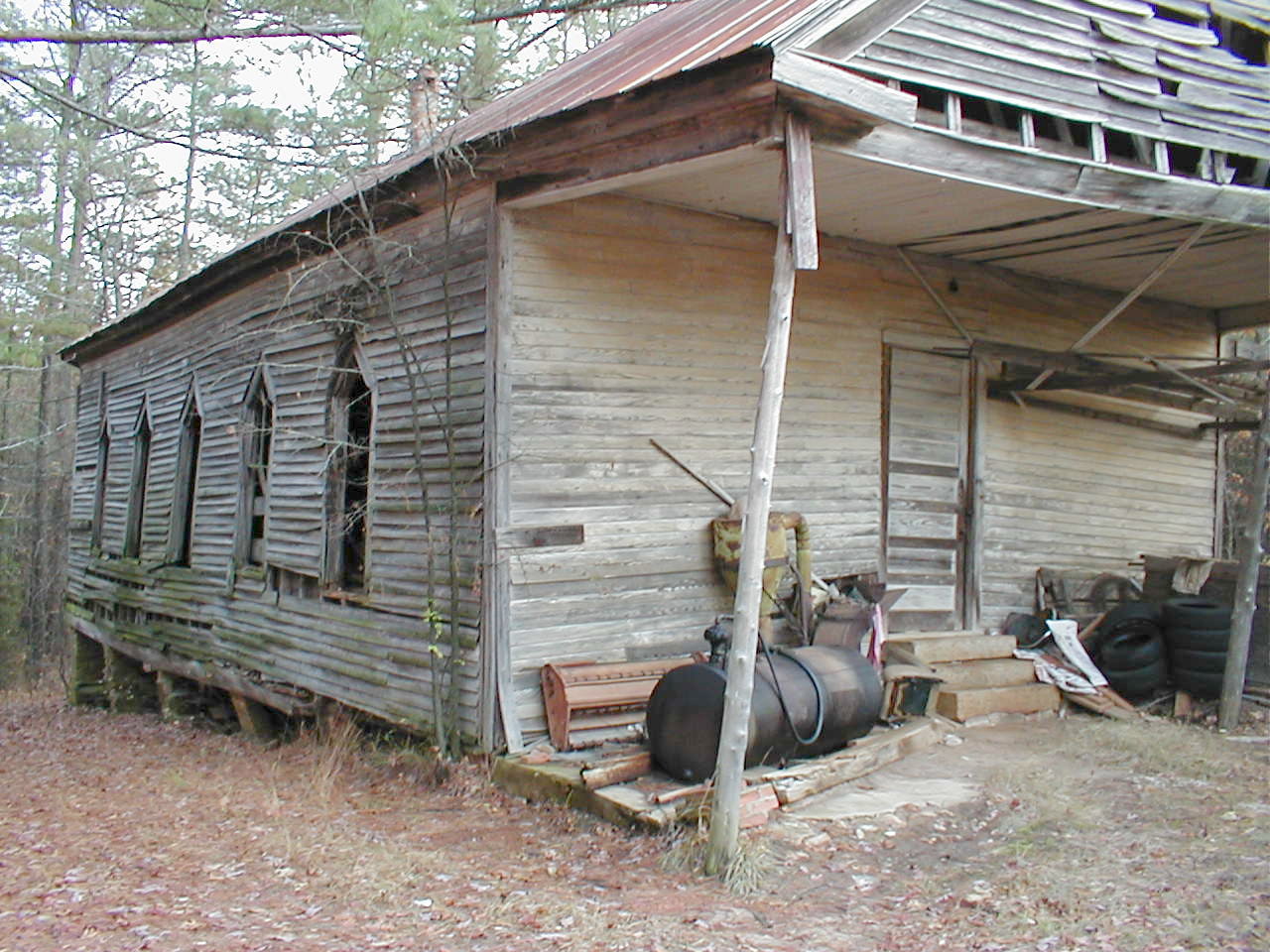
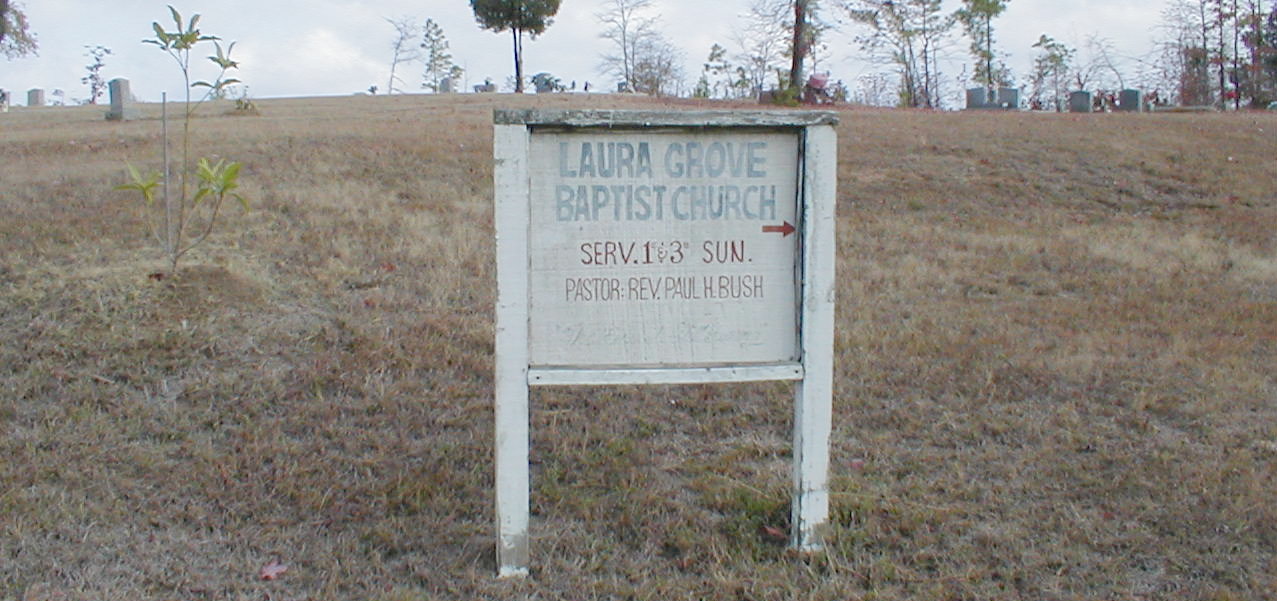
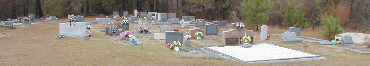
35-196 |
Laura Grove Baptist (N) |
Can't locate cemetery |
|
|
P |
|
|
|
35-CG-LG |
|
|
35-053 |
Laurel Grove Baptist (N) |
n33 41.000 , w82 10.710 |
A |
M |
P1 |
|
|
|
|
N of Laurel Grove Church Rd, E of US 221, Clarks
Hill |
|
35-197 |
Lebanon Baptist |
Can't locate cemetery |
|
|
P1 |
|
|
|
|
Part of Old Abbeville County ? |
|
35-198 |
Lebanon Presbyterian (est. 1821) |
Can't locate cemetery |
|
|
P1 |
|
|
|
|
Part of Old Abbeville County ? |
|
35-054 |
Lee Family
|
n34
01.486 , w82 26.270 |
A |
M |
P |
T |
|
35-B1-P031 |
|
0.4 miles behind St. Marys
Church, Troy |
|
35-055 |
LeRoy Family |
Can't locate cemetery
|
|
|
P |
T |
|
35-B1-P031 |
|
N of Morrah Bridge Rd, N of
Willington location:
Go north of McCormick to Willington. Turn
right on Road S 33-39. Follow this road past electric
power station. Pass two houses on left and turn left
approx. 3/10 mile at old road leading to old house.
Follow this approx. 1/2 mile to end of old road.
Cemetery is located at end of this road. |
|
35-082 |
LeRoy Family (old) |
Can't locate cemetery
|
|
|
P |
T
|
|
35-B1-P032 |
|
location: Go north from
McCormick to Willington.
Turn right at Willington Post Office and
follow this road to second house on left. An old road bed leading
to
left is just beyond this house. Follow this old road
approx. 1/10 mile,
then walk into the woods at old
homesite (large oak trees) to left approx.
1/10 mile. |
|
35-056 |
LeRoy Family |
Can't locate cemetery |
|
|
P |
|
|
35-B1-P032 |
|
aka 35-082 ?,
LeRoy Family (old),
French Huguenot |
|
35-199 |
Lindsay Family |
Can't locate cemetery |
|
|
P |
|
|
|
|
|
|
35-057 |
Little
Mill Baptist |
n33
57.200 , w82 27.150 |
A |
M |
P |
|
|
|
35-CG-LM |
Little Mill Church Rd, W of
Moss Ave, McCormick, 230 Little Mill Church Rd
McCormick, SC 29835 (864) 391-2262 |
|
35-058 |
Long Cane ARP
Presbyterian |
n34
00.938 , w82 20.910 |
A |
M |
P1
P2
P3 |
T
T
T |
|
35-B1-P032 |
|
Long Cane Rd, E of Old
Charleston Rd, Troy, originally part of Abbeville County, est. 1771 |
|
35-087 |
Lyon-Patterson-Wideman Family |
Can't locate cemetery
|
|
|
P |
T |
|
35-B1-P090 |
|
location: Behind home of Mr.
& Mrs. Raymond Henderson, on old road to Troy. |
|
35-220 |
Macedonia Fire Baptised Holiness (N) |
n33 56.570 , w82 14.778 |
A |
M |
P |
|
|
|
35-CG-MFB |
Old Post Rd, 0.35m E of US221, McCormick |
|
35-059 |
MaGrath Family
|
N33 55.386 , W82 23.306
|
A |
M
|
P |
T |
|
35-B1-P066 |
|
GPS-JH, location: Go
north from McCormick on Hwy
28, turn left at first road past Buffalo Church S-33-276. Proceed on
this road until you reach a silo on
right. Follow old road on left side of main road. This
old road bears to right until you reach the lake edge.
Watch for several very old
oak trees. Cemetery
situated around them. An old wire fence long since
rusted away once surrounded the cemetery which
contains 5 marked gravesites. Size of fence lends
evidence of more graves but no mounds or markers of
any kind proves this. |
|
35-200 |
Mapleton Plantation Family
+ Slave Cemetery ? |
Can't locate cemetery |
|
|
P |
|
|
|
|
Owner: Sam
Edmonds, Between Little River & Savannah River |
|
35-060 |
Mars Family |
n34 01.228 , w82 27.145 |
A |
M |
P1 |
T |
|
35-B1-P066 |
|
GPS-JH, 1500 ft N of Mars
Bridge Rd, E of Mars Rd,
Troy |
|
35-066 |
Mason-McKie Family |
n33
37.400 , w82 07.867 |
A |
M |
P |
T |
|
35-B1-P066 |
|
GPS-JH, 150 ft W of Rt 28, S
of Woodlawn Rd, Clarks
Hill |
|
35-221 |
Martha Chapel UMC Methodist (N) |
n33 55.153 , w82 17.893 |
A |
M |
P |
|
|
|
35-CG-MC |
McCracken St, N of Bradley St, McCormick |
|
35-222 |
Martha Chapel UMC Methodist, Old (N) |
n33 51.933 , w82 22.418 |
A |
M |
P |
|
|
|
35-CG-OMC |
100' W of Holiday Rd, 700' S of Bordeaux Rd,
Savannah Lake Village |
|
35-061 |
Martin Family |
N33 54.344 , W82 24.333
|
A |
|
P1 |
T |
|
35-B1-P067 |
|
GPS-JH, Bordeaux Rd, N of US 378,
McCormick, location: Go west of McCormick on Hwy. 378. Turn
right on Bordeaux road. Park in yard of second house
(Creed
Silvers). Burial ground is located approx. 400
yards behind and slightly to the left of this house. |
|
35-062 |
Mathis Family (Marthas?) |
Can't locate cemetery
|
|
|
P |
T |
|
35-B1-P68 |
|
location: Go west of
McCormick on Hwy. 378. Turn
right on Bordeaux road. Park in
yard of second house (Creed Silvers).
Burial ground is located approx. 400
yards behind and slightly to the left of this house. |
|
35-063 |
McAllister's Chapel Holiness (N) |
n34
03.067 , w82 31.650 |
A |
M |
P1 |
|
|
|
35-CG-MCH |
McAllister Chapel Rd, N of
Calhoun Mill Rd, Calhoun
Falls |
|
35-064 |
McCaslan Family |
Can't locate cemetery
|
|
|
P |
T |
|
35-B1-P041 |
|
E of Foster Rd, W of Rt 28,
Troy, location: Go
approx. 10 miles north of McCormick on Hwy. 28 to
road S 33-37. Follow this road approx. 6/10 mile past
first house on right. Cross fence on right and follow
power line left approx. 500 yards. Cemetery located
on hill overlooking creek. Ivy covered trees surround
cemetery. Cemetery surrounded by indigenous rock
wall with iron gate approx. 40" wide. Walls intact and
in good condition. |
|
35-065 |
McCormick Community Cemetery |
n33
54.483 , w82 17.567 |
A |
M |
P1
Pr
* |
T |
|
35-B1-P042 |
|
US 221, S of US 378,
McCormick |
|
35-077 |
McCormick (UMC?) Methodist
(old) |
N33 55.583 , W82 19.161 |
A |
|
P |
T |
|
35-B1-P077 |
|
aka New Cemetery
GPS-JH, Dirt road, S of Rt 28 near
Rt 10, McCormick, location: Go north from McCormick to fork on
Highway 10 & 28. Turn left on Highway 28, then again
at first dirt road past fork. Follow this road
approximately .1 mile. Cemetery is on left of road at
first curve. |
|
35-201 |
McKinney |
Can't locate cemetery |
|
|
P |
T |
|
|
|
location: Go north from McCormick on highway 10 &
28. Turn left at first road past railroad.
Follow this road past Bob Edmonds' photo studio until you reach
fork at end of paved road. Turn sharp left at fork
onto unpaved road. Follow this dirt road to fork.
Cemetery is located in this fork beneath a big oak
tree. |
|
35-067 |
McKinney Family |
Can't locate cemetery |
|
|
P |
T |
|
35-B1-P066 |
|
S of McCormick on "old
road", from McCormick to
Plum Branch |
|
35-068 |
Middleton Family |
n33
39.583 , w82 10.150 |
A |
M |
P |
T |
|
35-B1-P068 |
|
GPS-JH, 400 ft W of Rt 28, S of
Lukes Ferry Rd, Clarks
Hill |
|
35-069 |
Modoc Baptist |
n33
44.100 , w82 12.350 |
A |
M |
P1
P2 |
T |
|
35-B1-P068 |
|
US 221, N of Wizards Cove
Rd, Modoc |
|
35-202 |
Morton Family |
Can't locate cemetery |
|
|
P |
T |
|
|
|
White Town Section (of what?) |
|
35-070 |
Mount
Carmel Cemetery |
n34
00.717 , w82 30.567 |
A |
M |
P1
P2 |
T |
|
35-B1-P071 |
|
Mt Carmel Cemetery Rd, S of
Rt 81, Mt. Carmel |
|
35-071 |
Mount
Lebanon Church |
n33
46.870 , w82 12.360 |
A |
M |
P |
|
|
|
35-CG-ML |
S33-93 & Mt Lebanon Church
Rd |
|
35-072 |
Mount
Moriah Baptist |
n33
54.733 , w82 21.800 |
A |
M |
P1 ? |
|
|
|
35-CG-MMM |
Barksdale Ferry Rd, W of
Hugenot Pkwy, McCormick |
|
35-073 |
Mount
Moriah Baptist |
n33
50.500 , w82 08.539 |
A |
M |
P1 ? |
|
|
|
35-CG-MMPB |
E of Key Rd, S of Rt 283,
Plum Branch |
|
35-074 |
Mount
Pleasant AME Methodist (N) |
n33
58.933 , w82 32.650 |
A |
M |
P1 |
|
|
|
35-CG-MP |
Fort Charlotte Rd, S of
33-168, Mt. Carmel |
|
35-075 |
Mount
Vernon Methodist |
n33
57.617 , w82 05.517 |
A |
M |
P1 |
T |
|
35-B1-P075 |
|
Long Cane Rd, E of Scotts
Ferry Rd, Troy |
|
35-076 |
Mount
Zion AME Methodist (N) |
n33
58.567 , w82 24.367 |
A |
M |
P |
|
|
|
35-CG-MZ |
Mt. Zion Church Rd, E of
Richey Rd, McCormick |
|
35-203 |
Murray Plantation Family
+ Slave Cemetery ?
|
Can't locate cemetery |
|
|
P |
|
|
|
|
Hard Labor Creek |
|
35-078 |
Hope Baptist (new) (N) |
n33
52.450 , w82 14.933 |
A |
M |
P |
|
|
|
35-CG-NH
|
New Hope Rd & 33-67,
McCormick |
|
35-079 |
Newby Cemetery |
|
|
|
P1 |
T |
|
35-B1-P078 |
|
Rt 28 & Barksdale Ferry Rd,
McCormick, location:
Go north from McCormick on
Highway 28 approx. 3 miles. Cemetery is located on right side of highway
at intersection of Country Club road and Hwy 28.
Fire tower is located
nearby. |
|
35-171 |
Newby-Wideman Family |
n33 56.550 , w82 20.633 ???
N33 05.800 , W82 25.636 ??? |
A
A |
M
M |
P |
T |
|
35-B1-P107 |
|
aka Cox Family
GPS-JH, Wideman Cemetery Rd,
W of Red Row Rd, McCormick |
|
35-080 |
Noble, Patrick (Governor) |
n33 56.720 , w82 30.768 |
A |
M |
P1
P2 |
T
T |
|
35-B1-P078 |
|
E of Rd 563A, W of Leroys
Ferry Rd,
Gov. Patrick Noble Historical marker, cross
railroad, turn right, proceed to Willington Cemetery sign, turn
left here
and travel this road past Willington
Cemetery approximately .1 mile to
sign "Grave of Gov. Patrick Noble." Turn right at
this sign and go to end of this road which is approximately 2
1/2 miles. Cemetery is located at the end of the
road by the lake. Cemetery is surrounded by brick
wall approximately 4 feet high with no gate. |
|
35-204 |
Oak Grove Plantation Family
+ Slave Cemetery ?
|
34 007N, 82 435W ? |
|
|
P |
|
|
|
|
Owner: William B. Dorn |
|
35-226 |
Ouzts Family |
33.921882, -81.958151 |
A |
M |
|
|
|
|
|
1m S of Long Cane Rd (S-19-21) on Ouzts Rd at its end |
|
35-083 |
Overbrook Cemetery |
n33
55.517 , w82 16.917 |
A |
M |
P1 |
T |
|
35-B1-P079 |
|
US 221 & Overbrook Dr,
McCormick |
|
35-084 |
Palmer Family |
Can't locate cemetery
|
|
|
P |
T |
|
35-B1-P079 |
|
This cemetery located behind
and just to the right of Mr. Jimmie Edmunds' place on Road S
33-. Situated in clump of hardwood trees at edge of
open pasture field. |
|
35-085 |
Parksville Baptist |
n33
47.152 , w82 13.022 |
A |
M |
P1
P2 |
T |
|
35-B1-P084 |
|
Church St, Parksville, on
the east side of Sec. Rd. S-33-93, established 1785 |
|
35-086 |
Parksville Methodist |
n33 47.296 , w82 13.150 |
A |
M |
P |
T |
|
35-B1-P089 |
|
Mt.View Rd & Blackwell Rd, Parksville |
|
35-205 |
Petigru Plantation Family
+ Slave Cemetery ? |
Can't locate cemetery |
|
|
P |
|
|
|
|
Owners: Bayfield, China, Goodwell, Grove,
Petigru,
Ryeworth, Tidlam |
|
35-089 |
Pine Grove AME Methodist (N) |
n33 49.800 , w82 21.017 |
A |
M |
P1 ? |
|
|
|
35-CG-PG |
Pine Grove Church Rd, S of Rt 28, Plum Branch |
|
35-088 |
Piney
Grove Baptist |
n33
49.417 , w82 17.217 |
A |
M |
P2 ? |
|
|
|
|
Fishing Village Rd & Landam
Creek Rd, Plum Branch |
|
35-207 |
Pleasant Grove Plantation
+ Slave Cemetery ? |
|
|
|
P |
|
|
|
|
Owner: John Bull
Near Willington |
|
35-090 |
Plum Branch Baptist |
n33
51.083 , w82 15.167 |
A |
M |
P1
P2
Pr
* |
T |
|
35-B1-P090 |
|
Old Augusta Rd, N of Rt 283,
Plum Branch |
|
35-177 |
Porcher Family |
Can't locate cemetery |
|
|
|
T |
|
|
|
2m E of Willington |
|
35-091 |
Price Family |
N33 54.890 , W82 20.640 |
A |
|
P |
T |
|
35-B1-P094 |
|
aka Mount Tabor Church
GPS-JH, location: Go north of McCormick to
entrance of McCormick Country Club. Follow
dirt road to left of entrance of Country Club approx. .7
mile. Cemetery is located on right side of
this road on hillside to northwest. No fence. |
|
35-092 |
Quattlebaum Family |
n33 58.093 , w82 08.205 |
A |
M |
P1 |
T |
|
|
|
Long Cane Rd, 0.6 miles W of
Rt 67, Troy |
|
35-208 |
Republic |
Can't locate cemetery |
|
|
Pr
* |
|
|
|
|
aka 35-093 Republican UMC? |
|
35-093 |
Republican UMC Methodist |
n33
51.733 , w82 20.483 |
A |
M |
P1
P2 |
T |
|
35-B1-P095 |
|
33-124, 2 miles S of US 378,
McCormick |
|
35-094 |
Rehoboth Baptist (new ?) |
n33
50.467 , w82 08.800 |
A |
M |
P1 ?
P2 ? |
T ? |
|
35-B1-P096 |
|
Behind church, Key Rd, S of
Rt 283, Plum Branch, location: Seven miles east of Plum Branch, on east
side of Sec. Rd. S-33-138, 1/2 mile south of SC 283 |
|
35-095 |
Rehoboth Baptist (1811-1860) (old) |
n33 50.497 , w82 08.801 |
A |
M |
P1 ?
Pr
* |
T ? |
|
35-B1-P100 |
|
North side of church, Key Rd, S of Rt 283, Plum
Branch |
|
35-096 |
Robertson Family |
n33 50.620 , w82 16.925 |
A |
M |
P1 |
T |
|
|
|
50 ft N of Collier St, N of
Saddle Club Rd, Plum Branch |
|
35-097 |
Rockford AME Methodist (N) |
n34
00.867 , w82 30.567 |
A |
M |
P1 |
|
|
|
35-CG-R |
Rt 81, W of Rt 823, Mt. Carmel |
|
35-209 |
S-33-114 Cemetery |
Can't locate cemetery |
|
|
P1 |
|
|
|
|
From downtown McCormick, take US-221/SC-28 SE to
SC-283; take SC-283 E to S-33-138; take S-33-138 N to S-33-114; take
S-33-114 W; going 0.9 miles W on S-33-114, S-33-436 goes S;
going approximately 0.4 W of S-33-436 on S-33-114,
S-33-114 crosses a creek. Cemetery is located S of
S-33-114 less than 0.1 mile W of S-33-436. |
|
35-098 |
Saint Charlotte Baptist |
n33
55.233 , w82 25.317 |
A |
M |
P1 |
|
|
|
35-CG-SC |
St. Charotte Rd, N of
Willington Academy Rd,
McCormick |
|
35-223 |
Saint Goodwell Baptist (N) |
n34 02.519 , w82 22.990 |
A |
M |
P |
|
|
|
35-CG-SG |
W of 28, 1.1m S of Abbeville County Line |
|
35-100 |
Saint Mary AME Methodist (N) |
n34
01.417 , w82 25.967 |
A |
M |
P |
|
|
|
35-CG-SM |
Mars Bridge Rd, W of Rt 28, Troy |
|
35-099 |
Saint Paul AME Methodist (N) |
n34 04.468 , w82 29.030 |
A |
M |
P |
|
|
|
35-CG-SP |
St. Paul Church Rd, S of Island Ford Rd, Calhoun
Falls |
|
35-101 |
Sanders Family |
Can't locate cemetery
|
|
|
P1 |
T |
|
35-B1-P103 |
|
300 ft E of Talbert Rd, N of
US 378, McCormick, location: Go west on 378 to S 33-211, turn right and
go .3 mile to old road on right. Cemetery approx.
100 yards on right of this road (within town limit). |
|
35-102 |
Scott Family |
N33 59.480 , W82 28.018 |
A |
|
P |
T |
|
35-B1-P103 |
|
GPS-JH, location: This cemetery is located
deep in the forest northeast of Willington. Remains of
roads leading to cemetery no longer visible. |
|
19-171 |
Seigler Family |
n33.898825 , w82.141871
(Originally Edgefield County ?) |
A |
M |
|
|
F |
|
|
aka
Ziegler
Cemetery
is located on original Seigler plantation grounds, now located in Sumter National Forrest, 15
miles NW of Edgefield |
|
35-109 |
Self-Sturkey Family |
N33 52.704 , W82 15.381 |
A |
|
P |
T |
|
35-B1-P104 |
|
GPS-JH, Near New Hope
Church, deep in woods,
Plum Branch |
|
35-103 |
Sheppard Family |
n33 57.770 , w82 02.930 |
A |
M |
P |
T |
|
35-B1-P103 |
|
500 ft W of US 25, N of Long
Cane Rd, Troy |
|
35-104 |
Shiloh
AME Methodist (N) |
n33
56.250 , w82 19.100 |
A |
M |
P |
T |
|
|
35-CG-SLO |
Rt 10, W of Troy Rd,
McCormick |
|
35-210 |
Silt Hope Plantation Family
+ Slave Cemetery ?
|
Can't locate cemetery
|
|
|
P |
|
|
|
|
aka
Manigault's Plantation ? |
|
35-105 |
Spring
Grove Baptist (N) |
n33
59.217 , w82 32.217 |
A |
M |
P1 |
|
|
|
|
Fort Charlotte Rd, E of
33-168, Mt. Carmel |
|
35-106 |
Springfield AME Methodist (N) |
n33
51.900 , w82 20.317 |
A |
M |
P |
|
|
|
|
33-124, 1.7 miles S of US
378, McCormick |
|
35-107 |
Springfield Green Olive AME Methodist (N) |
n33
56.965 , w82 26.560 |
A |
M |
P |
|
|
|
35-CG-SGO |
123 Guillebeaux Cemetery Rd, S
of Moss Ave (33-196), McCormick |
|
35-108 |
Stalnaker or Zaner Family ? |
Can't locate cemetery
|
|
|
|
|
|
35-B1P104 |
|
W of 33-81, Troy, location:
Go north from McCormick
on Highway 28 to road S-33-81 (left). Follow S-33-81
approx. 1/2 mile past old Hopewell Church. Turn left
onto second road to left. Turn left on this road at the
fifth old Sawmill road. Cemetery is approx. 1/10 mile
on left of this old Sawmill road. |
|
35-224 |
Strait Gate Apostolic (N) |
n33 54.826 , w82 19.728 |
A |
M |
P |
|
|
|
35-CG-SGAT |
Straight Gate Church Rd, N of Cedar Hill Rd,
McCormick |
|
35-218 |
Talbert Family |
N33 55.800 , W82 21.130
|
A |
|
P |
|
|
|
|
GPS-JH, N off SC-28 |
|
35-110 |
Talbert Family |
n33 50.703 , w82 10.568 |
A |
M |
P |
T ? |
|
35-B1-P104 |
|
Forest Rd, S of Rt 283, W of
Cunningham Rd, Plum Branch |
|
35-111 |
Talbert Family |
n33 46.255 , w82 12.434 |
A |
M |
P |
T ? |
|
35-B1-P105 |
|
Go east
from Plum Branch on SC 283
approx. 5 miles and turn sharp right onto first dirt
road past National Forest Rifle range. Follow this dirt
road approx. 8/10 mile to a small creek. Cross bridge
and travel approx. 1/10 mile to fork of road. Follow left
fork; cemetery is located on left of road approx. 1/10
mile. Watch closely with a keen eye because this
cemetery is approx. 50 yards from the road and hard
to see due to undergrowth, saplings, etc. |
|
35-112 |
Talbert Family, Ansel |
n33 46.272 , w82 12.366
|
A |
M |
P |
T ? |
|
35-B1-P105 |
|
Known as the Ansel Talbert burying
ground; located west of Plum Branch on Hwy 283.
Turn to right on U.S.
Forestry graveled road beyond
Byrd Creek Rifle Range. Cemetery is on left in large
grove of oak trees. At one time there was a wagon
road from the Rehoboth Baptist Church to the Talbert
plantation. |
|
35-113 |
Thompkins Family (aka 35-114 ?) |
n33 46.255 , w82 12.434 |
A
|
M |
P |
|
|
35-B1-P106 |
|
Between Old Augusta Rd, & US
221, N of Cedar Rd, Modoc |
|
35-114 |
Tompkins Family Plantation
+ Slave Cemetery ? |
n33
46.255 , w82 12.434 |
A |
M |
P |
T |
|
35-B1-P107 |
|
Could be unknown #9,
33.77120, -82.20610 or
33.84656, -82.26751 |
|
35-115 |
Tranquil AME Methodist (N) |
n33
59.283 , w82 14.717 |
A |
M |
P |
|
|
|
35-CG-TV |
Long Cane Rd, E of US 221,
Troy |
|
35-225 |
True Vine Progressive Church (N) |
n33 56.800 , w82 16.822 |
A |
M |
P |
|
|
|
35-CG-TV |
33-52 Bell Field Rd, 0.5m E of Bradley Rd, McCormick |
|
35-211 |
Truitt Family |
N33 57.331 , W82 21.497 |
A |
M |
P |
|
|
|
|
GPS-JH |
| |
|
|
|
|
|
|
|
|
|
|
| |
CLARKS HILL
COMMUNITY |
|
|
|
|
|
|
|
|
|
|
35-116 |
Unknown Name #01 |
n33
39.369 , w82 11.357 |
A |
M |
P |
|
|
|
|
2000 ft S of US221, E of
Thurmond Dam, Clarks Hill |
|
35-117 |
Unknown Name #02 |
n33
41.075 , w82 11.035 |
A |
M |
P |
|
|
|
|
500 ft N of US 221 & Laurel
Church Rd, Clarks Hill |
| |
|
|
|
|
|
|
|
|
|
|
| |
McCORMICK COMMUNITY |
|
|
|
|
|
|
|
|
|
|
35-146 |
Unknown Name #31 |
n33
54.410 , w82 20.015 |
A |
M |
P |
|
|
|
|
500 ft S of Cedar Hill Rd, 1
mile W of Dillashaw Rd,
McCormick |
|
35-147 |
Unknown Name #32 |
n33
54.744 , w82 22.442 |
A |
M |
P |
|
|
|
|
Near Katie Ln, N of Ameila
Dr, McCormick |
|
35-148 |
Unknown Name #33 |
n33
55.115 , w82 09.739 |
A |
M |
P |
|
|
|
|
1500 ft S of Scotts Ferry
Rd, 0.7 mile E of Liberty Hill
Rd, McCormick |
|
35-149 |
Unknown Name #34 |
n33
55.603 , w82 10.854 |
A |
M |
P |
|
|
|
|
200 ft E of Liberty Hill Rd
& Cuffey Town Creek Rd,
McCormick |
|
35-151 |
Unknown Name #36 |
n33
55.822 , w82 09.155 |
A |
M |
P |
|
|
|
|
300 ft N of Scotts Ferry Rd,
0.6 mile N of US 378, McCormick |
|
35-152 |
Unknown Name #37 |
n33
55.949 , w82 11.608 |
A |
M |
P |
|
|
|
|
50 ft E of Zion Chapel Rd,
1400 ft N of Zion Chapel,
McCormick |
|
35-163 |
Unknown Name #48 |
n33
58.325 , w82 12.381 |
A |
M |
P |
|
|
|
|
1200 ft N of Dowlin Rd, 0.5
miles W of Liberty Hill Rd,
McCormick |
|
35-164 |
Unknown Name #49 |
n33
58.597 , w82 20.690 |
A |
M |
P |
|
|
|
|
Off of rd, 565C, S of Long
Cane Rd, McCormick |
|
35-165 |
Unknown Name #50 |
n33
58.620 , w82 14.746 |
A |
M |
P |
|
|
|
|
500 ft W of Wright Rd, S of
Dowlin Rd, McCormick |
| |
|
|
|
|
|
|
|
|
|
|
| |
MODOC COMMUNITY |
|
|
|
|
|
|
|
|
|
|
35-118 |
Unknown Name #03 |
n33
41.755 , w82 11.308 |
A |
M |
P |
|
|
|
|
1000 ft E of US 221, N of
Pine Tree Ln, Modoc |
|
35-119 |
Unknown Name #04 |
n33
43.028 , w82 10.907 |
A |
M |
P |
|
|
|
|
1.2 miles E of US 221, S of
Smalley Rd, Modoc |
|
35-120 |
Unknown Name #05 |
n33
43.075 , w82 12.344 |
A |
M |
P |
|
|
|
|
200 ft W of US 221, 500 ft N
of 33-221, Modoc |
|
35-121 |
Unknown Name #06 |
n33
43.655 , w82 12.321 |
A |
M |
P |
|
|
|
|
200 ft E of US 221, 300 ft S
of Jasper Rd, Modoc |
|
35-122 |
Unknown Name #07 |
n33
45.423 , w82 11.403 |
A |
M |
P |
|
|
|
|
3500 ft E of US 221 & 33-26,
Modoc |
|
35-123 |
Unknown Name #08 |
n33
45.257 , w82 11.585 |
A |
M |
P |
|
|
|
|
3200 ft E of US 221, 1200 ft
S of Unknown #07, Modoc |
|
35-128 |
Unknown Name #13 |
n33
47.562 , w82 09.047 |
A |
M |
P |
|
|
|
|
S end of Cedar Springs Rd,
Modoc |
|
35-129 |
Unknown Name #14
|
n33
49.254 , w82 09.211 |
A |
M |
P |
|
|
|
|
50 ft W of Key Rd, 1500 ft S
of 33-138, Modoc |
| |
|
|
|
|
|
|
|
|
|
|
| |
PARKSVILLE
COMMUNITY |
|
|
|
|
|
|
|
|
|
|
35-124 |
Unknown Name #10 |
n33
47.492 , w82 12.008 |
A |
M |
P |
|
|
|
|
S of Prices Mill Rd, W of
Mt. Lebanon Rd. Parksville |
|
35-118 |
Unknown Name #11 |
n33
47.425 , w82 12 .748 |
A |
M |
P |
|
|
|
|
200 ft W of Prices Mill Rd,
E of Oak Hill St, Parksville |
| |
|
|
|
|
|
|
|
|
|
|
| |
PLUM BRANCH
COMMUNITY |
|
|
|
|
|
|
|
|
|
|
35-135 |
Unknown Name #20 |
n33
52.002 , w82 10.310 |
A |
M |
P |
|
|
|
|
S of Harmony Rd, W of
33-436, Plum Branch |
|
35-136 |
Unknown Name #21 |
n33
52.814 , w82 14.393 |
A |
M |
P |
|
|
|
|
1000 ft N of Whitetown Rd,
0.5 miles E of New Hope
Rd, Plum Branch |
|
35-137 |
Unknown Name #22 |
n33
53.340 , w82 13.296 |
A |
M |
P |
|
|
|
|
1000 ft N of end of El
Aquator Rd, N of Whitetown Rd,
Plum Branch |
|
35-138 |
Unknown Name #23 |
n33
53.465 , w82 12.917 |
A |
M |
P |
|
|
|
|
1800 ft NE of Unknown #22, N
of Whittown Rd, Plum Branch |
|
35-143 |
Unknown Name #28 |
n33
54.062 , w82 09.876 |
A |
M |
P |
|
|
|
|
40 ft W of 33-602, W of Key
Rd, Plum Branch |
|
35-144 |
Unknown Name #29 |
n33
54.316 , w82 12.066 |
A |
M |
P |
|
|
|
|
100 ft SW of Iron Bridge Rd
& 33-280, Plum Branch |
|
35-145 |
Unknown Name #30 |
n33
54.148 , w82 11.593 |
A |
M |
P |
|
|
|
|
700 ft E of 33-280, 0.5
miles S of Iron Bridge Rd,
Plum Branch |
| |
|
|
|
|
|
|
|
|
|
|
| |
TROY COMMUNITY |
|
|
|
|
|
|
|
|
|
|
35-156 |
Unknown Name #41 |
n33
56.695 , w82 07.124 |
A |
M |
P |
|
|
|
|
2000 ft E of Rt 67, 0.6
miles N of Windmill Rd, Troy |
|
35-157 |
Unknown Name #42 |
n33
56.703 , w82 07.001 |
A |
M |
P |
|
|
|
|
250 ft NE of Unknown #41 |
|
35-159 |
Unknown Name #44 |
n33
57.331 , w82 21.548 |
A |
M |
P |
|
|
|
|
2000 ft W of Windmill Rd,
0.5 miles S of Mt. Vernon
Rd, Troy |
|
35-161 |
Unknown Name #46 |
n33
58.134 , w82 06.310 |
A |
M |
P |
|
|
|
|
1000 ft N of Cox Rd, W of
Mt. Vernon Rd, Troy |
|
35-166 |
Unknown Name #51 |
n33
59.203 , w82 14.337 |
A |
M |
P |
|
|
|
|
50 ft S of Long Cane Rd, 0.8
miles E of US 221, Troy |
|
35-167 |
Unknown Name #52 |
n33
59.122 , w82 17.056 |
A |
M |
P |
|
|
|
|
200 ft N of Eden Hall Rd,
1600 ft E of Cemetery Rd,
Troy |
| |
|
|
|
|
|
|
|
|
|
|
|
35-212 |
Vickery Family (old) |
N34 01.693 , W82 22.159
|
A |
|
Pr
* |
|
|
|
|
GPS-JH |
|
35-169 |
White
Family |
Can't locate cemetery |
|
|
P |
T |
|
35-B1-P107 |
|
Near Iron Bridge Rd & White
Town Rd location: From
Highway 378 turn right on S-33-42,
traveling east from McCormick.
Follow this road.
Cemetery is located to
the left near the power line just before the White Town
Road is reached. |
|
35-170 |
White
Rock Road Cemetery (N) |
n33
53.033 , w82 19.567 |
A |
M |
P |
|
|
|
35-CG-WR |
E of White Rock Rd & 33-392,
McCormick |
|
35-213 |
Wideman Plantation Family
+ Slave Cemetery ? |
N33 59.483 , W82 22.486
? |
A ? |
M ?
|
P1
P2 |
T |
|
|
|
aka Ivy Gates Plantation
GPS-JH, location: Go north from McCormick on
Highway
28 to road S-33-38. Turn right and travel
approx. 2 miles to dirt road FAP S-530, old house.
"Ivy Gates," on left at this intersection.
Follow dirt road, cross creek, then turn sharp right on first
main dirt road. Go 1 mile. Cemetery located approx.
100 yards from right side of road, 36 Slaves in 1860.. |
|
35-214 |
Wideman Cemetery |
n33 56.550 , w82 20.652 |
A |
M |
P1 |
T |
|
|
|
aka Red Row
Red Row is the name for the
section of the county
in which the cemetery is
located. Brick Red Carolina
clay is located throughout the
area.
|
|
35-173 |
Willington Church |
n33 57.417 , w82 28.550 |
A |
M |
P1 |
T |
|
35-B1-P110 |
|
E of Willington Academy Rd on
33-135 Spur, McCormick |
|
35-174 |
Yeldell Family |
Can't locate cemetery |
|
|
P |
T |
|
35-B1-P116 |
|
US 378, location: Behind home of Mr. & Mrs. E. L.
Hollingsworth, Hwy. 378, East |
|
35-175 |
Young Family |
Can't locate cemetery |
|
|
P1 |
T |
|
35-B1-P116 |
|
33-36, Troy, location: Follow road S-33-36
from Troy toward Covered Bridge, Cemetery is located on left
of road on hill between old Young home place and
Covered Bridge. |
|
35-176 |
Zion Chapel AME Methodist (N) |
n33 55.767 , w82 11.417 |
A |
M |
P1 |
|
|
|
35-CG-ZC |
33-23, N of US 378, McCormick |
|
|
|
|
|
|
|
|
|
|
|
|
|
|
|
|
|
|
|
|
|
|
|
Next Ref. # = 35-227 |
