 |
 |
 |
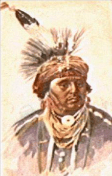
Index - Treaties - Choctaw East Nation

| 1750 | Grandpre' Treaty | Sept., with the French, which reduced the Choctaw Nation to a French dependency. [REF:#24, p28] | 1765 | Mobile Treaty | 26th Mar., with the English, which defined their Eastern boundary and forbade the encroachment of white settlers within their territory. [REF:#24, p31] | 1786 | Hopewell Treaty | First U.S. & Choctaw Nation, at Hopewell on the Keowee River, South Carolina. [REF:#24, p32] | 1792 | Friendship Treaty | 14th May, at Fort Nogales, near the mouth of the Yazoo. [REF:#33, p31] | 1801 | Fort Adams Treaty | 18th Dec., 2,641,920 acres, of land was ceded for $2,000 | 1802 | Treaty | 1803 | Treaty | 1805 | Treaty | 1816 | Treaty | 1820 | Treaty | 1830 | Treaty |
The CHOCTAWS who some had been relocated in the now state of Arkansas Treaty of 1816, had created friction between white settlers and the Indians and led eventually to the establishment of a "permanent" western boundary for Arkansas.
The Treaty of Doak's Stand 1820, about 1,000 CHOCTAW moved from their ancestral homes East of the Mississippi to West of the Mississippi in the then Arkansas Territory. This provided a new Eastern boundary for the CHOCTAW settlements on a line extending North from the mouth of the Little River to the Arkansas River.
In 1824 Congress fixed the Western boundary of the Arkansas Territory on a line of 40 miles West of the Southwest corner of Missouri. As surveyed by John C. Brown, the new Arkansas boundary cut through the lower Kiamici River near the stream's mouth and crossed West of the Three Forks area. This act was a clear violation by the United States of the Treaty of Doak's Stand - 1820
The Arkansas delegate to Congress, HENRY W. CONWAY, protested the New Arkansas Treaty line of 1824. Declaring in a letter to Secretary of War JOHN C. CALHOUN that such a boundary would cut off a large number of Arkansas citizens (who should have NOT settled on Indian land in the first place ..prs) from the protection of Arkansas.
Because of white squatters into the Arkansas Territory, a new treaty of Treaty of 1825 required the CHOCKTAWS to ceded to the United States all of its land in the Arkansas Territory and move farther West to the present day Oklahoma.
The Treaty of Dancing Rabbit, September 30, 1830 the CHOCTAWS ceded All their land east of the Mississippi to the United States for In exchanged they received the land in the Southeast corner of theWESTERN INDIAN TERRITORY (Oklahoma) lying between the western boarder of Arkansas and the 100th meridian, with the Red River as the Southern boundary and the Canadian- Arkansas rivers as their Northern limit.
However, a considerable body of Choctaw did not leave at this time. Many followed, it is true, at the time of the allotment in Oklahoma, but upward of a thousand still remain, principally in the neighborhood of Philadelphia, [Neshoba Co.] MS.
The western Choctaw established a government on the model of those of the other civilized tribes and that of the United States, and it was not given up until merged in the State of Oklahoma early in the present century.
 Choctaw Index |
N.A. Index |
 SFA - Index |
 E-Mail:
Paul R. Sarrett, Jr. Auburn, CA.
E-Mail:
Paul R. Sarrett, Jr. Auburn, CA.Text - Copyright © 1996-2002 Paul R. Sarrett, Jr.
Created: Dec. 01, 1996;
 Mar. 25, 2002