 |
Some Catawba History (Part 2.) Native American Catawba Nation |
 |
|
Some Catawba History (Part 2.) Native American Catawba Nation |
|
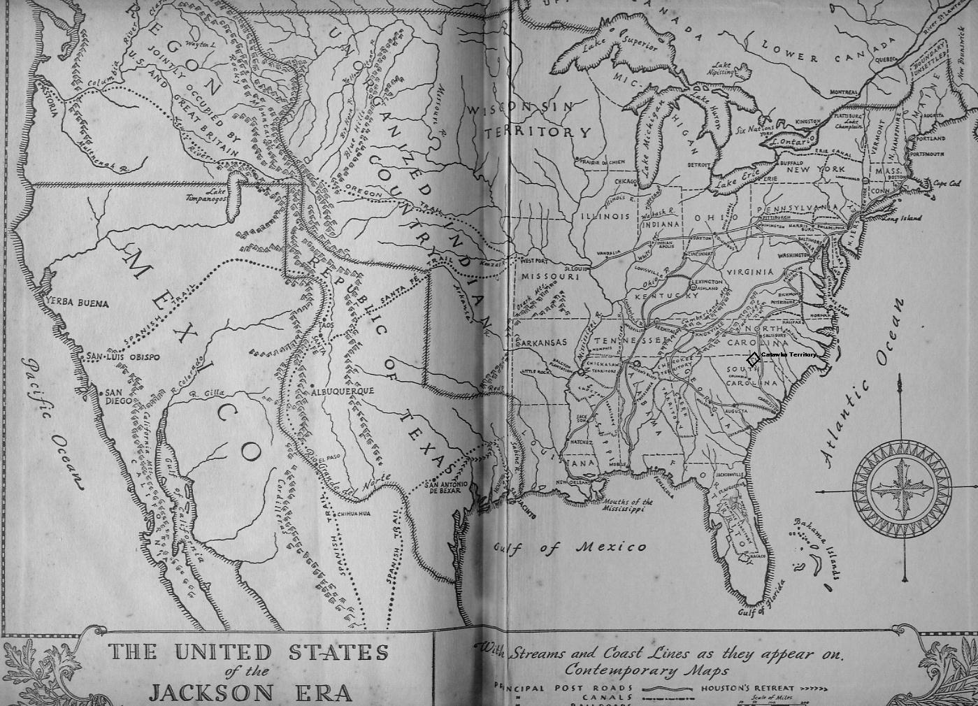
"The Indian Tribes of North America" By John R. Swanton, Pub. 1920
This list the Native Americans, History; Place Names; Sub-divisions;
in SOUTH CAROLINA.

Catawba tribe. - Significance unknown though the name was probably
native to the tribe. Also called:
Ani'ta'gua, Cherokee name.
Iswa or Issa, signifying "river," and specifically the Catawba River;
originally probably an independent band which united early with the
Catawba proper. Iroquois name.
Oyadagahroenes, Iroquois name.
Tadirighrones, Iroquois name.
Usherys, from Iswahere, "river down here"; see Issa.

Catawba Connections.- The Catawba belonged to the Siouan linguistic
family, but Catawba was the most aberrant of all known Siouan languages,
though closer to Woccon than any other of which a vocabulary has been
recorded.

Catawba Loction.- In York and Lancaster Counties mainly but extending
into the neighboring parts of the State and also into North Carolina
and Tennessee.

Catawba Subdivisions. - Two distinct tribes are given by Lawson
(1860) and placed on early maps, the Catawba and Iswa, the latter
deriving their name from the native word meaning "river," which was
specifically applied to Catawba River.

Catawba Villages. - In early days this tribe had many villages but
few names have come down to us. In 1728 there were six villages, all
on Catawba River, the most northerly of which was known as Nauvasa.
In 1781 they had two called in English Newton and Turkey Head, on
opposite sides of Catawba River.

Catawba History.- The Catawba appear first in history under the
name Ysa, Issa (Iswa) in Vandera's narratives of Pardo's expedition
into the interior, made in 1566-67. Lederer (1912) visited them in
1670 and calls them Ushery. In 1711-13 they assisted the Whites in
their wars with the Tuscarora, and though they participated in the
Yamasce uprising in 1715 peace was quickly made and the Catawba remained
faithful friends of the colonists ever after.

Meanwhile they declined steadily in numbers from diseases introduced
by the Whites, the use of liquor, and constant warfare with the Iroquois,
Shawnee, Delaware, and other tribes. In 1738 they were decimated by
smallpox and in 1759 the same disease destroyed nearly half of them.
Through the mediation of the Whites, peace was made at Albany in 1759
between them and the Iroquois, but other tribes continued their attacks,
and in 1763 a party of Shawnee killed the noted Catawba King Haigler.

The year before they had left their town in North Carolina and moved
into South Carolina, where a tract of land 15 miles square had been
reserved for them. From that time on they sank into relative insignificance.
They sided with the colonists during the revolution and on the approach
of the British troops withdrew  temporarily into Virginia, returning
after the battle of Guilford Court House. In 1826 nearly the whole
of their reservation was leased to Whites, and in 1840 they sold all
of it to the State of South Carolina, which agreed to obtain new territory
for them in North Carolina.

The State refused to part with any land for that purpose, however,
and most of the Catawba who had gone north of the State line were
forced to return. Ultimately a reservation of 800 acres was set aside
for them in South Carolina and the main body has lived there ever
since few continued in North Carolina and others went to the Cherokee,
but most of these soon came back and the last of those who remained
died in 1889. A few Catawba intermarried with the Cherokee in later
times, however, and still live there, and a few others went to the
Choctaw Nation, in what is now Oklahoma, and settled near Scullyville.
These also are reported to be extinct.

Some families established themselves in other parts of Oklahoma, in
Arkansas, and near Sanford, Colo., where they have gradually been
absorbed by the Indian and White population. About 1884 several Catawba
were converted by Mormon missionaries and went to Salt Lake City,
and in time most of those in South Carolina became members of the
Mormon Church, although a few are Baptists. Besides the two divisions
of Catawba proper, the present tribe is supposed to include remnants
of about 20 smaller tribes, principally Siouan.

Catawba Population.-
Mooney (1900) estimates the number of Catawba in 1600, including the Iswa, at 5,000.
About 1692 the tribe was supposed to contain 1,500 warriors or about 4,600 souls;
In 1728, about 400 warriors or about 1,400 souls;
In 1743, after incorporating several small tribes, as having less than that number of warriors.
In 1752, we have an estimate of about 300 warriors, or about 1,000 people;
In 1755, 240 warriors;
In 1757, about 300 warriors and 700 souls;
In 1759, about 250 warriors.

Although there is an estimate accrediting them with 300 warriors in
1761, King Haigler declared that they had been reduced by that year,
after the smallpox epidemic of 1760, to 60 fighting men.
In 1763 fewer than 50 men were reported, and
in 1766 "not more than 60."
In 1773 there was estimated a total population of 400;
In 1780, about 490;
In 1784, about 250:
In 1822, about 450;
In 1826, about 110.
In 1881, Gatschet found 85 on the reservation and 35 on adjoining farms, a total of 120.

The census of 1910 returned 124,
In 1912 there were about 100, of whom 60 were attached to the reservation.
The census of 1930 gave 166, all but 7 in South Carolina Connection
in which they have become noted.

The Catawba, whether originally or by union with the Iswa,
early became recognized as the most powerful of all the Siouan peoples
of Carolina. They are also the tribe which preserved its identity
longest and from which the greatest amount of linguistic information
has been obtained.

The name Catawba itself was given to a variety of grape, and has
become applied, either adopted from the tribe directly or taken from
that of the grape, to places in:
Catawba County, NC.;
Roanoke County, Va.;
Marion County, W.Va.;
Bracken County, Ky.;
Clark County, Ohio;
Caldwell County, Mo.;
Steuben County, NY.;
Blaine County, Okla.;
York County, S. C.; and
Price County, Wis.
It is also borne by an island in Ohio, and by the Catawba River
of the Carolinas, a branch of the Wateree.

Cherokee tribe. -  In the extreme northwestern portion of the State
was occupied by Cherokee Indians. (See Cherokee Indians, Tennessee.)

Chiaha tribe. - A part of this tribe lived in South Carolina at
times. (See Chiaha tribe of Georgia.)

Chickasaw tribe. - The Chickasaw territory proper was in northern
Mississippi, at a considerable distance from the State under discussion,
but about 1753 a body of Chickasaw Indians settled on the South Carolina
side of Savannah River, to be near the English trading posts and to
keep in contact with the English, who were their allies. Before 1757
most of them moved over to the immediate neighborhood of Augusta and
remained there until the period of the American Revolution. In that
war they sided against the colonists and their lands were confiscated
in 1783. (See Chickasaw tribe of Mississippi.)

Congaree tribe. -  Meaning unknown.

Congaree Connection.- No words of this language have been preserved
but the form of the name and general associations of the tribe leave
little doubt that it was a Siouan dialect, related most closely to
Catawba.

Congaree Location.- On Congaree River, centering in the neighborhood
of the present State Capital, Columbia.

Congaree Village. - The only village mentioned bore the same name
as the tribe and was sometimes placed on the Congaree opposite Columbia,
sometimes on the north side of the river.

Congaree History.- The Congaree are mentioned in documents of the
seventeenth century as one of thc small tribes of the Piedmont region.
In 1701 Lawson (1860) found them settled on the northeast bank of
Santee River below the mouth of the Wateree. They took part against
the Whites in the Yamasec War of 1715, and in 1716 over half of them
were captured and sent as slaves to the West Indies. The remnant appear
to have retreated to the Catawba, for Adair (1930) mentions their
dialect as one of those spoken in the  Catawba Nation.

Congaree Population.- The Congaree are estimated by Mooney (1900)
at 800 in 1600. A census taken in 1715 gives 22 men and a total population
of about 40.

Congaree Connection in which they have become noted.- Congaree River
and a railroad station in Richland County, S. C., preserve the name;
Columbia, the State capital, was originally known as the Congarees.
Creeks. In the time of De Soto, Cofitachequi, which seems to have
been either Kasihta or Coweta, and a few other Creek towns including
perhaps Hilibi and part of the Chiaha Indians were in the territory
of the present State of South Carolina near Savannah River. The Coosa
of Coosawhatchie, Edisto, and Ashley Rivers may have been Creek in
origin, and in Inter times Creeks constantly resorted to the provincial
settlements in this area. (See Alabama.)

Cusabo tribe.- Meaning perhaps "Coosawhatchie River (people)."

Cusabo Connections.- There is little doubt that the Cusabo belonged
to the Muskhogean linguistic family. Their closest connections appear
to have been with the Indians of the Georgia coast, the Guale.

Cusabo Location.- In the southern-most part of South Carolina between
Charleston Harbor and Savannah River and including most of the valleys
of the Ashley, Edisto, Ashepoo, Combahee, Salkehatchie, and Coosawhatchie
Rivers.

Cusabo Subdivisions
These people should be divided first into the Cusabo proper, who occupied
all of the coast, and the Coosa, who were inland upon the rivers above
mentioned. The Cusabo proper seem to have consisted of a northern
group of tribes or subtribes, including the Etiwaw (on Wando River),
Wando (on Cooper River), Kiawa (on the lower course of Ashley River),
and perhaps the Stono (about Stono Entrance); and a southern group
including the Edisto (on Edisto Island), Ashepoo (on lower Ashepoo
River), Combahee (on lower Combahee River) Wimbee (between the latter
and the lower Coosawhatchie River), Escamacu (between St. Helena Sound
and Broad River), and perhaps a few others. Sometimes early writers
erroneously include the Siouan Senee and Santee as Cusabo.

Cusabo Villages, SC:
Ahoys or EIoya, on or near Broad River.
Ahoyabi, near the preceding.
Aluste, near Beaufort, possibly a form of Edisto.
Awendaw, near Awendaw Creek; it may have been Sewee (q. v.).
Bohicket, near Rockville.
Cambe, near Beaufort.
Chatuache, 6-10 leagues north of Beaufort.
Mayon, probably on Broad River.
Talapo, probably near Beaufort.
Touppa, probably on Broad River.
Yanahume, probably on the south side of Broad River.

Cusabo History.- While their country was most likely skirted by
earlier navigators, the first certain appearance of the Cusabo in
history is in connection with a slave-hunting expedition sent out
by Vasques de Ayllon. This reached the mainland in 1521, probably
a little north of the Cusabo territory and introduced the blessings
of White civilization to the unsuspecting natives by carrying away
about 70 of them. One of these Indians was finally taken to Spain
and furnished the historian Peter Martyr with considerable information
regarding his country and the names of a number of tribes, some of
whom were certainly Cusabo. In 1525 Ayllon sent a second expedition
to the region and in 1526 led a colony thither.

Dissatisfied with his first landing place, probably near the landfall
of the expedition of 1521, he moved the colony "40 or 45 leagues,"
perhaps to the neighborhood of Savannah River. But it did not prosper,
Ayllon died, trouble broke out among the survivors, and finally they
returned to Haiti in the middle of the following winter. In 1540 De
Soto passed near this country, but apparently he did not enter it,
and the next European contact was brought about by the settlement
of Ribault's first colony at Port Royal in 1562. The small number
of people left by Ribault managed to maintain themselves for some
time with the assistance of friendly natives, but, receiving no relief
from France, they became discouraged, and built a small vessel in
which a few of them eventually reached home. In 1564 a Spanish vessel
visited this coast for the purpose of rooting out the French settlement.

Later the same year a second Huguenot colony was established on St.
Johns River, Florida, and communication was maintained with the Cusabo
Indians. In 1565 this colony was destroyed by the Spaniards who visited
Port Royal in quest of certain French refugees, and the year following
Fort San Felipe was built at the same place. From this time until
1587 a post was maintained here, although with some intermissions
due to Indian risings.

In 1568- 70 a vain attempt was made to missionize the Indians. In
1576 a formidable Indian uprising compelled the abandonment of the
fort, but it was soon reoccupied and an Indian town was destroyed
in 1579 by way of reprisal. Next year, however, there was a second
uprising, making still another abandonment necessary. The fort was
reoccupied in 1582 but abandoned permanently 5 years later; and after
that time there was no regular post in the country but communication
was kept up between the Cusabo and St. Augustine and occasional visits
seem to have been made by the Franciscan Friars.

Between 1633 and 1665 we have notice of a new mission in Cusabo territory,
called Chatuache, but when the English settled South Carolina in 1670
there appears to have been no regular mission there and certainly
no Spanish post. Charleston was founded on Cusabo soil, and from the
date of its establishment onward relations were close between the
English and Cusabo. In 1671 there was a short war between the colonists
and the Coosa Indians and in 1674 there was further trouble with this
people and with the Stono.

In 1675 the Coosa Indians surrendered to the English a large tract
of land which constituted Ashley Barony, and in 1682 what appears
to have been a still more sweeping land cession was signed by several
of the Cusabo chiefs. In 1693 there was another short war, this time
between the Whites and the Stono. A body of Cusabo accompanied Colonel
Barnwell in his expedition against the Tuscarora in 1711-12, and this
fact may have quickened the consciences of the colonists somewhat,
because in 1712 the Island of Palawana, "near the Island of St. Helena,"
was granted to them.

It appears that most of their plantations were already upon it but
it had inadvertently been granted to a white proprietor. The Cusabo
here mentioned were those of the southern group; there is reason to
think that the Kiawa and Coosa were not included. Early in 1720 "King
Gilbert and ye Coosaboys" took part in Col. John Barnwell's punitive
expedition against St. Augustine (Barnwell, 1908). In 1743 the Kiawa
were given a grant of land south of the Combahee River, probably to
be near the other coast Indians. Part of the Coosa may have retired
to the Catawba, since Adair (1930) mentions "Coosah" as one of the
dialects spoken in the "Catawba Nation," but others probably went
to the Creeks. At least one band of Cusabo may have gone to Florida,
because, in "A List of New Indian Missions in the Vicinity of St.
Augustine," dated December 1, 1726, there is mention of a mission
of San Antonio "of the Cosapuya nation and other Indians" containing
43 recently converted Christians and 12  pagans.

Two years later we are informed that "the towns of the Casapullas
Indians were depopulated," though whether this has reference to the
ones in Florida or to those in their old country is not clear.

Cusabo Population.- Mooney (1900) estimates the number of southern
Cusabo, exclusive of the Edisto, at 1,200 in 1600, the Edisto at 1,000,
the Etiwaw at 600, and the Coosa at 600. He classifies the Stono with
the Westo, thereby falling into a common error. The colonial census
of 1715 gives the number of southern Cusabo as 295, including 95 men,
in 5 villages, while the Etiwaw (probably including the other northern
Cusabo) had 1 village, 80 men, and a total population of 240. There
were thus 535 Cusabo over all. The Coosa are nowhere mentioned by
name and were probably included with one or the other of these. The
55 Indians at the Florida mission above mentioned, consisting of individuals
of "the Cosapuya nation and other Indians," included 24 men, 13 women,
and 18 children.

Cusabotribe Connection in which they have become noted.- The first
part of the name Coosa is identical in origin with the first part
of the name of Coosawhatchie River, S. C., and a post village. The
people themselves are noted in history as the first in eastern North
America north of Florida among whom European settlements were begun.
They had an earlier and longer contact with Europeans than any other
Indians on the Atlantic seaboard except those of the Gulf of St. Lawrence
Eno. This tribe moved into the northern part of the State after 1716
and perhaps united ultimately with the Catawba. At some prehistoric
period they may have lived on Enoree River. (See North Carolina.)

Keyauwee tribe.- They settled on the Pee Dee after 1716 and probably
united with the Catawba. (See North Carolina.)

Natchez tribe.- A band of Indians of this tribe lived for several
years at a place called Four Hole Springs in South Carolina but left
in 1744 fearing the vengeance of the Catawba because of seven of that
tribe whom they had killed. (See Mississippi.)

Pedee tribe.- Meaning unknown, but Speck (1935) suggests from Catawba
pi'ri, "something good," or pi'here, "smart," "expert," "capable."

Pedee Connections.- No words of the language have survived but there
is every reason to suppose that it was a dialect of the Siouan linguistic
family.

Pedee Loction.- On Great Pee Dee River, particularly its middle
course.

Pedee Village. - No village names are known apart from the tribal
name, which was sometimes applied to specific settlements.

Pedee History.- The Pedee are first mentioned by the colonists of
South Carolina. In 1716 a place in or near their country called Saukey
(perhaps Socatee) was suggested as the site for a trading post but
the proposition to establish one there was given up owing to the weakness
of the Pedce tribe, who were thought to be unable to protect it. In
1744, the Pedee, along with Natchez Indians, killed some Catawba and
were in consequence driven from their lands into the White settlements.
Soon afterward most of them joined the Catawba, but some remained
near the Whites, where they are mentioned as late as 1755. In 1808
the Pedee and Cape Fear tribes were represented by one half-breed
woman.

Pedee Population.- Mooney, 1900, estimates the number of Pedee as
600 in 1600. The census of 1715 does not give them separate mention,
and they were probably included among the 610 Waccamaw or the 106
Winyaw.

Pedee Connection in which they have become noted.- The Great and
Little Pee Dee Rivers and a station in Marion County, S. C., also
a post village in Anson County, N. C., perpetuate the name of the
Pedee.

Saluda tribe. - Meaning unknown.

Saluda Connections. - These are uncertain but circumstantial evidence
indicates strongly that the Saluda were a band of Shawnee, and therefore
of the Algonquian stock.

Saluda Location. - On Saluda River.

Saluda History. - Almost all that we know regarding the Saluda is
contained in a note on George Hunter's map of the Cherokee country
drawn in 1730 indicating "Saluda town where a nation settled 35 years
ago, removed 18 years to Conestogo, in Pensilvania." As bands of Shawnee
were moving into just that region from time to time during the period
indicated, there is reason to think that this was one of them, all
the more that a "Savana" creek appears on the same map flowing into
Congaree River just below the Saluda settlement.

Saluda Population. - Unknown.

Saluda Connection in which they have become noted.- The name Saluda
is preserved by Saluda River and settlements in Saluda County, SC.;
Polk County, NC.; and Middlesex County, Va.

Santee tribe. - Named according to Speck (1935), from iswan'ti,
"the river," or "the river is there." Also called: Seretee, by Lawson
(1860).

Santee Connections. - No words of the Santee language have come
down to us, but there is little doubt that they belonged to the Siouan
linguistic family.

Santee Location. - On the middle course of Santee River.
Santee Villages. - The only name preserved is Hickerau, on a branch
of Santee River.

Santee History. - The Santee were first encountered by the Spaniards
during the seventeenth century, and in the narrative of his second
expedition Captain Ecija places them on Santee River. In 1700 they
were visited by John Lawson, who found their plantations extending
for many miles along the river, and learned that they were at war
with the coast people (Lawson, 1860). They furnished Barnwell (1908)
with a contingent for his Tuscarora campaign in 1711-12, but are said
to have taken part against the Whites in the Yamasee War of 1715.
In 1716 they were attacked by the Etiwaw and Cusabo, acting in the
interest of the colonists, and the greater part of them were carried
away captive and sent to the West Indies. The remainder were probably
incorporated with the Catawba.

Santee Population.- The number of Santee was estimated by Mooney
(1900) at 1,000 in 1600. In 1715 an Indian census gave them 43 warriors
and a total population of 80 to 85 in 2 villages.

Santee Connection in which they have become noted.- The name Santee
has been given permanency chiefly by its application to the Santee
River, S. C., but it has also been applied to a village in Orangeburg
County, S. C.

Sewee tribe. - Significance: perhaps, as Gatschet suggested, from
sawe', "island."

Santee Connections.- No words of their language have survived, but
the Sewee are regarded as Siouan on strong circumstantial grounds,
in spite of the fact that they are sometimes classed with the Cusabo.

Santee Location.- On the lower course of Santee River and the  coast
westward to the divide of Ashley River about the present Monks Corner,
Berkeley County.

Santee Villages. - In Lawson, writing about 1700, mentions a deserted
village in Sewee Bay called Avendaughbough which may have belonged
to them (Lawson, 1860). The name seems to be still preserved in the
form Awensdaw.

Santee History.- Possibly Xoxi (pronounced Shoshi or Shohi), one  of
the provinces mentioned by Francisco of Chicora, an Indian carried
from this region by the Spaniards in 1521, is a synonym of Sewee.
The name is mentioned by Captain Ecija in 1609. They may have been
the Indians first met by the English expedition which founded the
colony of South Carolina in 1670, when they were in Sewee Bay. They
assisted the English against the Spaniards, and supplied them with
corn. Lawson (1860) states that they were formerly a large tribe,
but in his time, 1700, were wasted by smallpox and indulgence in alcoholic
liquors. Moreover, a large proportion of the able-bodied men had been
lost at sea in an attempt to open closer trade relations with England.
Just before the Yamasee War, they were still living in their old country
in a single village, but it is probable that the war put an end to
them as a distinct tribe. The remnant may have united with the Catawba.

Santee Population.- Mooney (1900) gives an estimate of 800 Sewee
for the year 1600. In 1715 there were but 57.

Santee Connection in which they have become noted.- At an earlier
period this name was applied to the body of water now called Bulls
Bay. There is a post hamlet with this designation in Meigs County,
Tenn., but the name is probably of independent origin.


End of South Carolina Indian Tribes

--------------------------------------------------------------------------
This file was contributed for use in USGenWeb Archives by:
Paul R. Sarrett, Jr. Aug. 11, 1998                         ([email protected])

USGENWEB NOTICE:  In keeping with our policy of providing free information
on the Internet, data may be freely used by non-commercial entities,
as long as this message remains on all copied material. These electronic
pages cannot be reproduced in any format for profit or other presentation.
---------------------------------------------------------------------------

Catawba - Index
NAI - Index
SFA - Index
NAI - REF.
 These records are part of the "History American Indian Profile©"
by Volume - I. Sarratt/Sarrett/Surratt Family Profile©
These records are part of the "History American Indian Profile©"
by Volume - I. Sarratt/Sarrett/Surratt Family Profile©Compiled and self Published in Jun. 29, 1993 by Paul R. Sarrett, Jr. with the assistance of my late mother Mrs. M. Lucille (WILSON) SARRETT (1917-1987) The SFA "Work-Books" were compiled by "General, Languages, Tribes, Treaties, Wars, How to Research NA Ancestors, Bibliographies". In 1996 I started "Up-Loading" this material on the Sarratt/Sarrett/Surratt Families of America (SFA)© site. ..prs |
Would like to Exchange and Share information on SARRATT / SARRETT / SURRATT Families, contact me at:
 E-Mail:
Paul R. Sarrett, Jr. Auburn, CA.
E-Mail:
Paul R. Sarrett, Jr. Auburn, CA. Aug. 10, 2001;
Nov. 24, 2001;
Sep. 10, 2007;
Aug. 10, 2001;
Nov. 24, 2001;
Sep. 10, 2007;