| Map |
Title / Discription |
 |
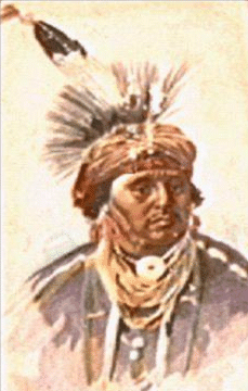
Native Americans in North America
Shows outline of Tribe locations in the United State early 1700's
No Rivers or Towns/Villages shown. |
 |
North America in 1700
(A History of U.S. , to 1876, NY., Alfred A. Knopf, 1959, Pg109)
Shows outline of the old Colonial syatem 1700 of the British, French, Spain.
No Rivers or Towns/Villages shown. |
 |
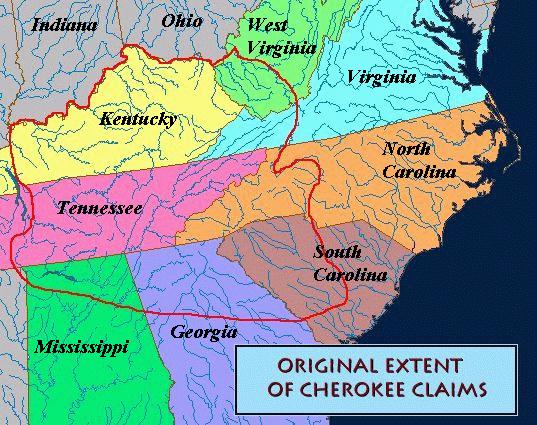
Map # 1. Original Extent of Cherokee Claims c1732
(Collection at the University of Georgia)
Shows outline of the Cherokee Nation prior to American Revolution;
No Rivers or Towns/Villages shown. |
|
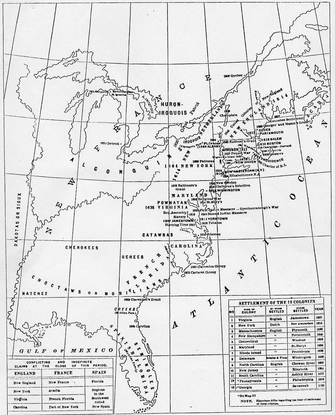
Map # 2. History Map of United States 1607~1733
(A Genealogical & History Atlas of United States, Pg55)
Map East of Mississippi River of Settlements, 13 Colonies, listing
Native American Indian Nations, with date of Colonies.
|
 |
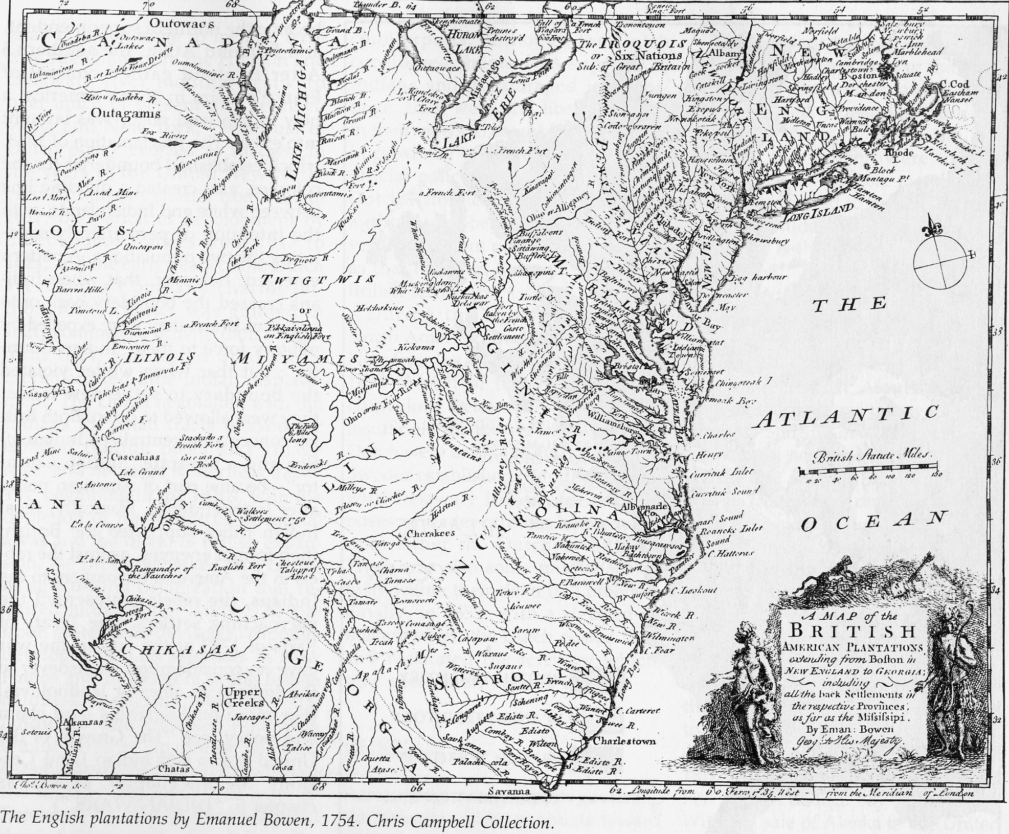
Map # 2.1 The English Plantations, by Emanuel Bowen, 1754
A Map of the British, "American Plantations"
Extending from Boston in New England to Georgia
Incliding all the back Settlements in the respective Provinces
as far West as the Mississippi River.
by: Eman Bowen, Geog' to his Majesty.
with Latitude & Longitude; Rivers & Streams.
Source: Chris Campbell Collection
|
 |
Map # 2.2 Cherokee Nation (East) c1760
By T. KITCHEN, from an Infian drawing, 1760
"A New Map of the Cherokee Nation" with the names of the Towns & Rivers
They are sutuaded on North Lat. 34 to 36 deg.
(U.S. Library of Congress)
|
 |
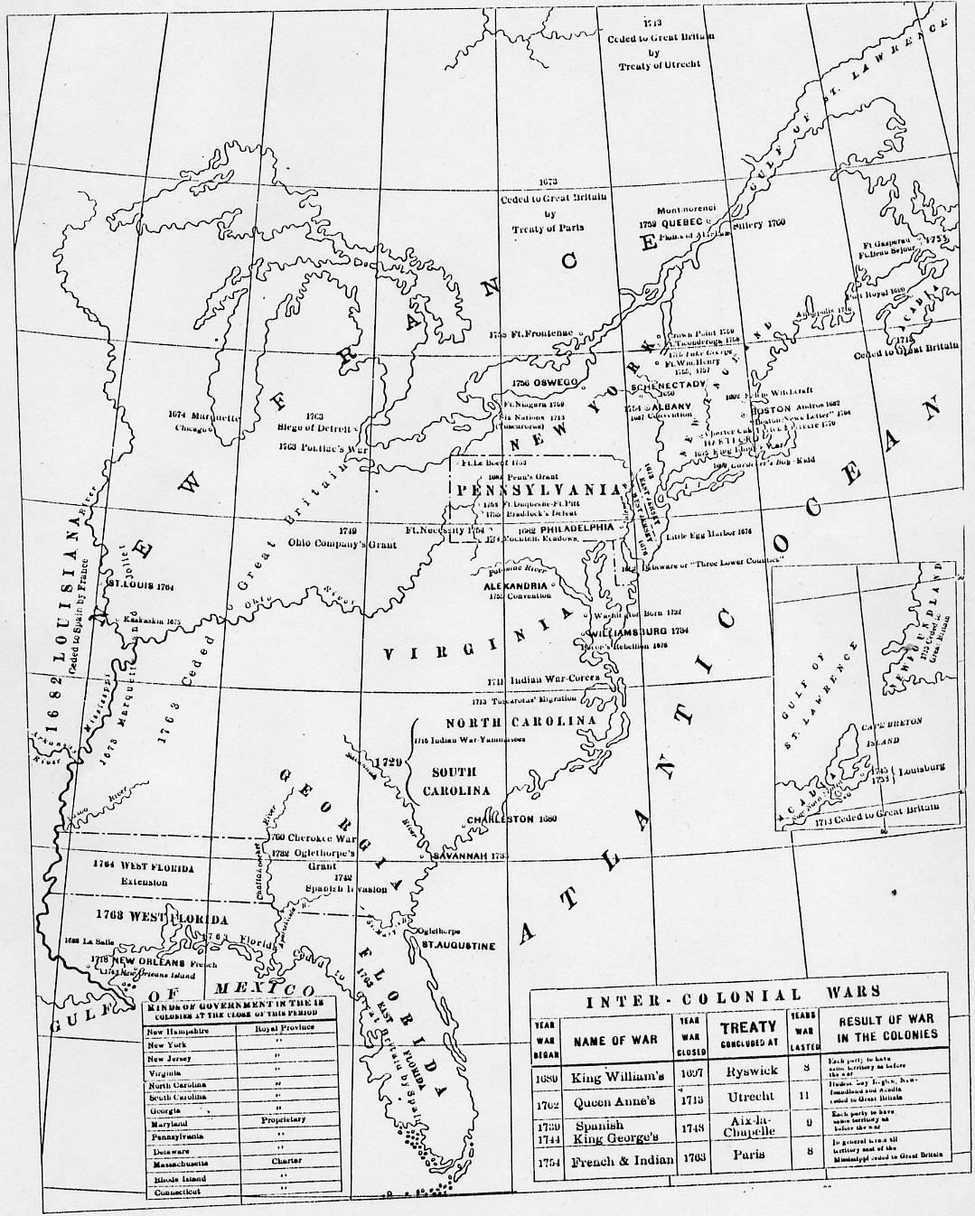
Map # 3. History Map of United States 1680~1763
(A Genealogical & History Atlas of United States, Pg56)
Map East of Mississippi River of Inter - Colonial Wars; Kinds of
Government in the 13 Colonies at the close of 1763.
|
 |
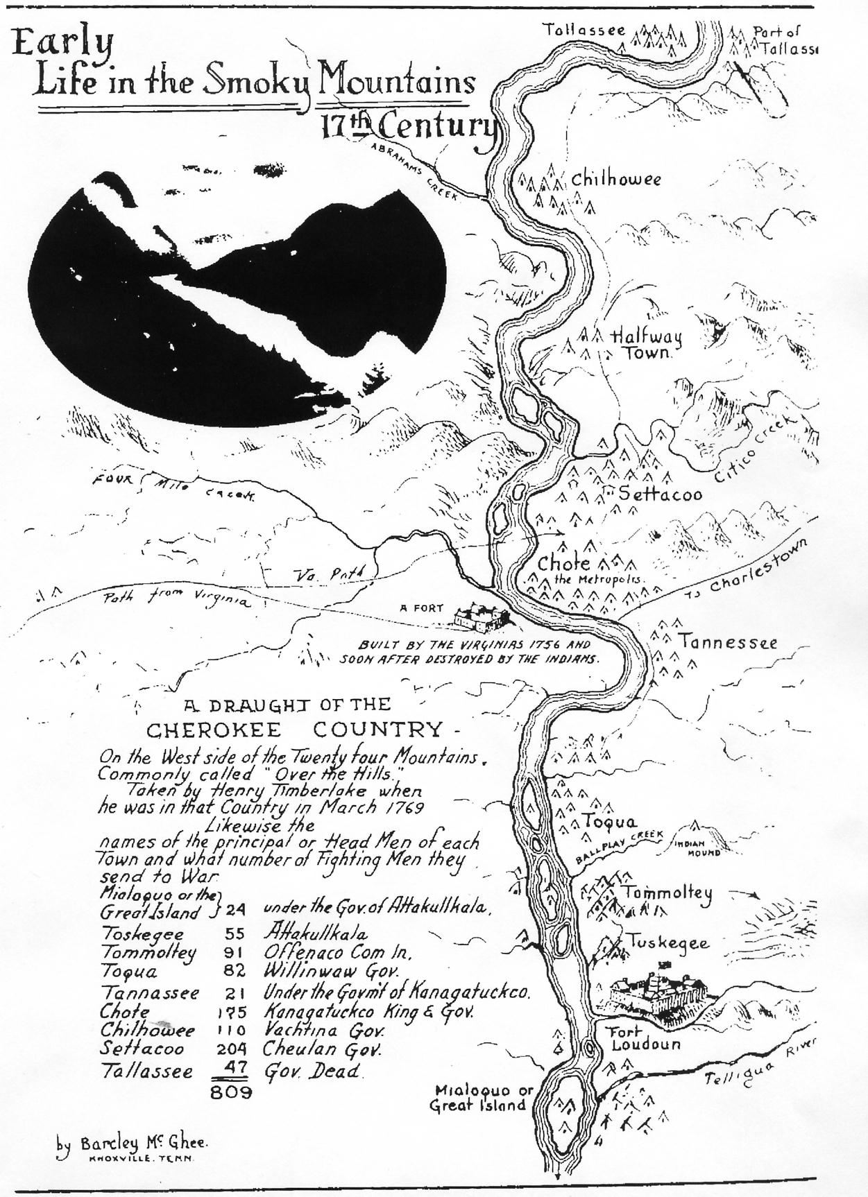
Map # 3.1 Early Life in the Smoky Mountains
17th Century March 1769
Henry Timberlake, March 1769, present-day Monroe Co., TN.)
By Barcley McGHEE, Enlargement, showing Rivers, Towns and Villages.
A Draught of the "Cherokee Country". On the West side of the "Twenty Four Mountains".
Commonly called "Over the Hills". Taken by Henry Timberlake when he was in that Country
in March 1769. Likewise the names of the Principal or Head Men of each and what number of
Fighting Men they had to send to War.
Up & down the Little Tennessee River, Monroe Co., TN., home of nearly
a thousand Cherokee Warriors, in 1769.
|
 |
Map # 3.2 White Settlements of the
East Cherokee Country 1763~1775
(Jaifr, Vol. 1, #3, Pg52)
Map of original Cherokee Nation boundaries showing the "Watauga" purchase
of 1772 and the "Brown's" purchase of 1775.
|
 |
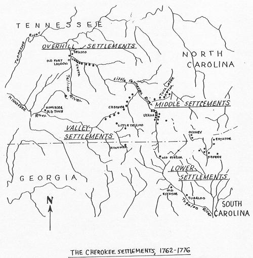
Map # 3.2b Cherokee Settlements of the
East Cherokee Country 1762~1776
(by Unknown)
Map of East Cherokee Nation Settlements.
|
 |
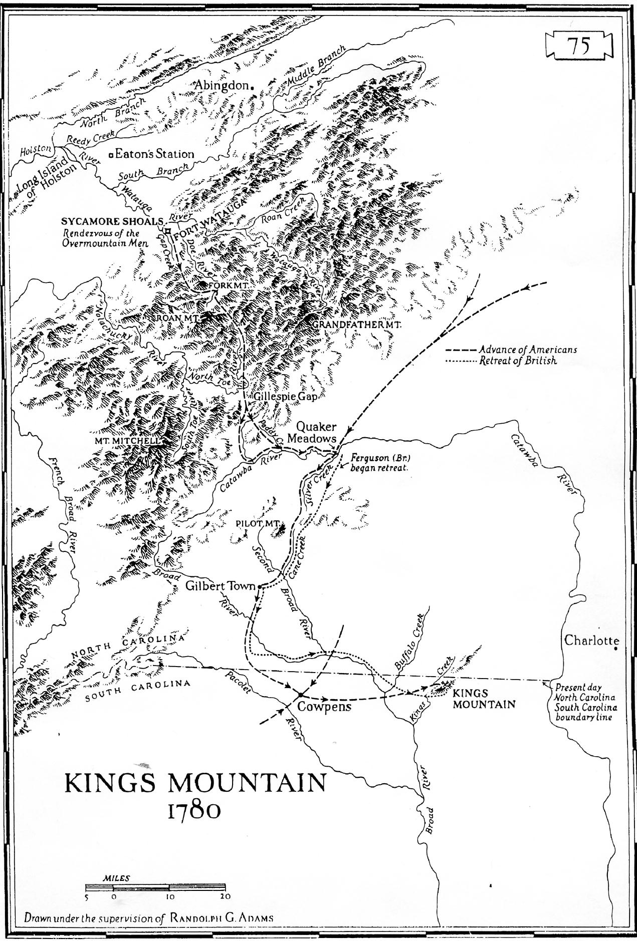
(The Revolutionary War in the South)
Map # 3.3 Kings Mountain, North Carolina, 1780
Bytes: 179,762 Date: 02-04-96 Size: 1996x2875x256
Drawn under supervision Randolph G. ADAMS
Enlargement, showing Rivers, Towns, Villages, Advancements of
the Americans and British troops. (ARW)
|
 |
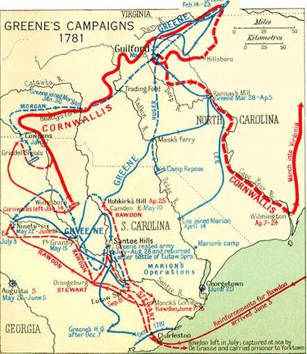
Map # 3.c GREEN's Campaigns of 1781
Enlargement, showing Rivers, Towns, Villages, Advancements of
the Americans and British troops. (ARW)
|
 |
Map # 3.d Theater of Operation
in Southern Campaign, 1781~1783
(From: History of North Carolina, by Samuel A'Court ASHE.; Greensboro, NC. 1908)
Enlargement, showing Rivers, Towns, Villages, Advancements of
Green's, Morgan's, Lee's, Cornwallis's & Rowden's troops.
|
 |
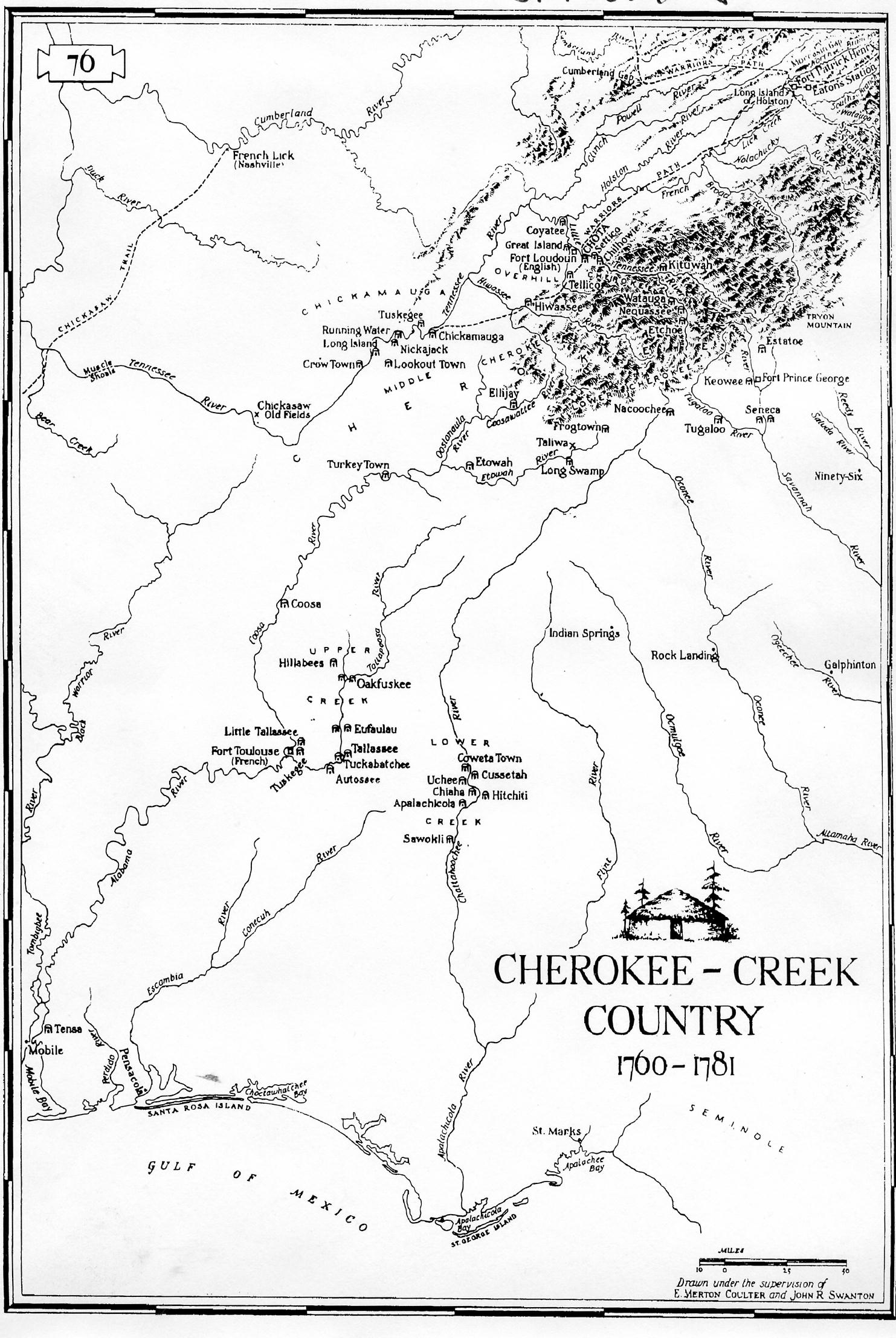
Map # 4. Cherokee - Creek Country, 1760~1781
Drawn under supervision E. Merton COULTER & John R. SWANTON, Pg. #76
Enlargement, showing Rivers, Towns and Villages.
From: The Indian tribes of North America [microform]
 <---
See: Bio. Swanton, John Reed SWANTON, (1873-1958)
Washington : U.S.G.P.O., Pub. 1952.
vi, 726 p. : maps. ; 24 cm. <---
See: Bio. Swanton, John Reed SWANTON, (1873-1958)
Washington : U.S.G.P.O., Pub. 1952.
vi, 726 p. : maps. ; 24 cm.
|
 |
Map # 4.a The Cherokee Country (East) 1793~1838
Bytes: 325,577 Date: 12-09-95 Size:3379x2326x2
Drawn under supervision by <---
See: Bio. James MOONEY (1861-1921)
Enlargement, showing Rivers, Towns and Villages.
From: Myths of the Cherokee
Bueau of American Ethnology, 19th Annual Report, PL. II;
Julius Bien & Co., Lith, NY. Pulb. 1900
|
 |
Map # 4.b The Cherokee & their Neighbors, 1793~1838
Bytes: 325,577 Date: 12-09-95 Size:3379x2326x2
Drawn under supervision by <---
See: Bio. James MOONEY (1861-1921)
Showing the Territory held by them at various times, West of the Mississippi River.
From: Myths of the Cherokee ~ 1900
Bueau of American Ethnology, 19th Annual Report, PL. I
Julius Bien & Co., Lith, NY., Page
|
 |
Map # 4.c The Cherokee Country, 1760~1781
(Compiled from Maps by STUART, HUNTER, & C.C. ROYCE, J.P. Brown 1937)
Bytes: 177,249 Date: 12-09-95 Size: 2522x2191x2
Enlargement, showing Rivers, Towns, Villages, Forts, Fortified
Stations, Missions, Important Sites, Indian trails, Pioneer Roads
and present-day State lines.
|
 |
Map # 4.d "The Revolutionary War in the South" 1780~1782
Drawn under supervision Hugh T. LEFLER, Pg. 86
Enlargement, showing Rivers, Towns, Villages, Advancements of
the Americans and British troops in South and North Carolina.
|
 |
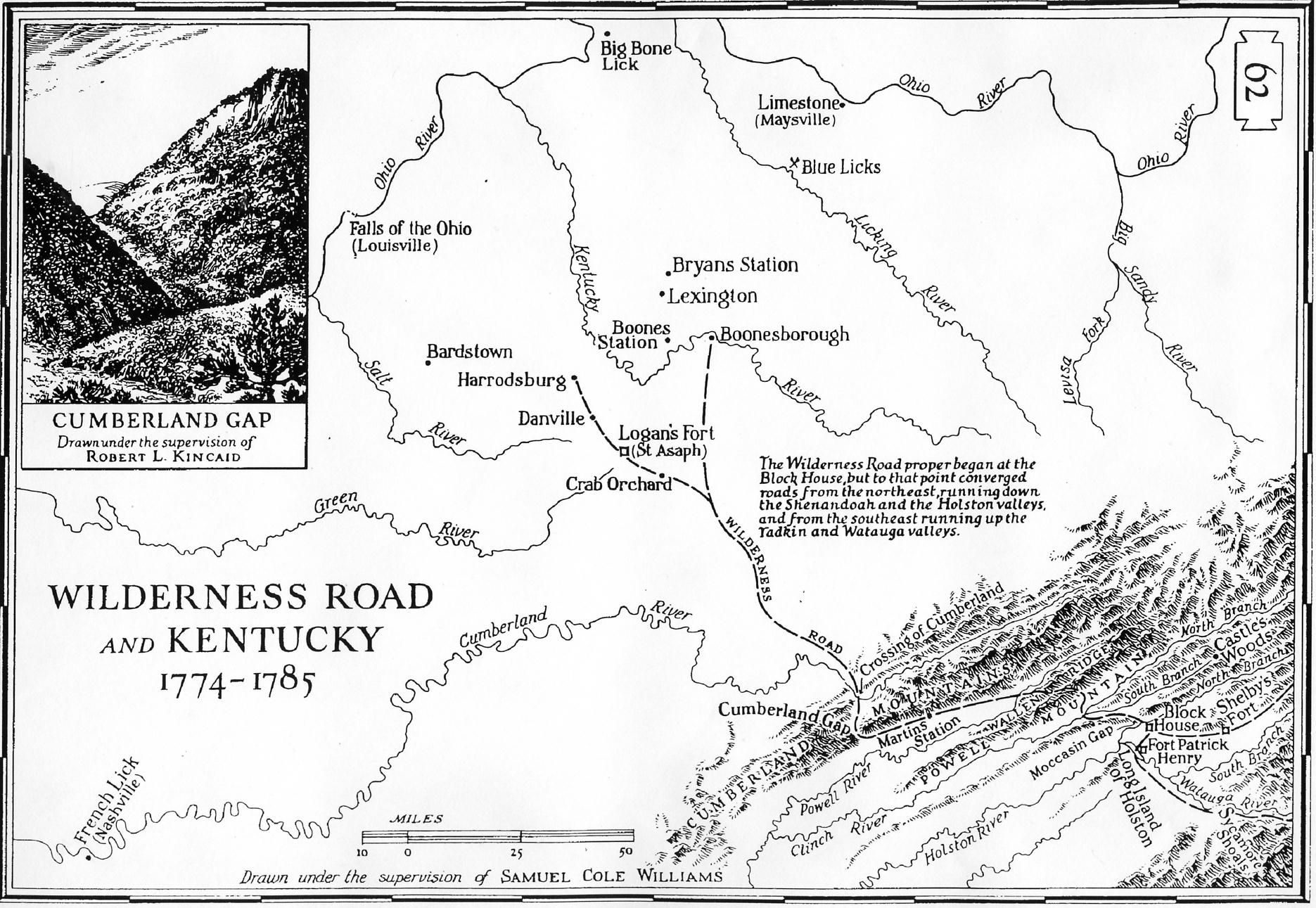
Map # 5. Wilderness Road And Kentucky, 1774~1785
Drawn under supervision Samuel Cole WILLIAMS, Pg #62
Enlargement, showing Rivers, Towns, Villages, Forts and Cumberland Gap.
CUMBERLA.GIF Bytes: 197,447 Date: 02-12-96 Size: 1992x2874x256
The "Wilderness Road proper began at the "Block House", but to that point
converged roads's from the northeast, running down the "Shenandoah and the "Holston Valleys",
and from the southeast running up the "Tadkin and Watauga" valleys."
ftp://ftp.rootsweb.com/pub/usgenweb/sc/maps/cumberla.gif
(a.k.a. "The Path of Buffalo and Warriors"
During the 17th century, the American bison, after a 1,100 year hiatus,
resumed a migratory pattern into the southeast portions of North America.
Besides foraging for grazing areas, these large path-
makers sought the numerous salt licks that dotted present Kentucky and Virginia,
and in doing so beat out a well-defined trace. During the next two centuries
travelers could follow such traces on roads extending from near Roanoke,
Virginia to central Illinois. Just as this network of traces served as a
corridor for native peoples, so it served the European frontiersmen and
settlers who followed. Foremost among Indian routes in the eastern United
States was the Warrior's Path, which looped southward through the Cumberland Gap,
connecting the Ohio valley and that of the Shenandoah and the Potomac.
Branches of the road also continued southeast to the Cherokee and Creek settlements.
In short, the path laid down by animals and native peoples was ready to be adapted
by opportunists from the colonies on the Atlantic seaboard.
Early travelers included Gabriel Arthur and Dr. Thomas Walker in the
17th and 18th centuries, respectively. Walker's account in 1750 gives
the first Anglo eyewitness description of Cumberland Gap, the entrance
of the present Cudjo Caverns, the spring emanating from it, and the Indian
road Walker followed. During the French and Indian War (1754-1763),
exploration and travel temporarily halted. But in 1763 a group of "long hunters"
led by Elisha Walden (Wallen) crossed into Kentucky through Cumberland Gap.
Success of the hunt brought others to Kentucky, including Daniel Boone, the
individual most identified with the Gap, who traversed it in 1769.
[Source: <---
http://www.nps.gov/cuga/wildrnss.htm]
|
 |
Map # 6. History Map United States, 1774~1788
(A Genealogical & History Atlas of United States, Pg57)
Bytes: 179,762 Date: 02-04-96 Size: 1150x1454x2
Map East of Mississippi River, showing territories and "Cession" dates
for the period of 1774 to 1788.
|
 |
Map # 6.1 The United States of America, 1795
by W. Barker, Philadelphia, Penn.
East of the Mississippi River, with Latitude & Longitude; Rivers & Streams.
|
 |
Map # 6.2 The United States of America, 1795
by W. Barker, Philadelphia, Penn.
East of the Mississippi River, the 13 Colonies marked in color, with Latitude & Longitude; Rivers & Streams.
|
 |
Map # 7.1 Cherokee & Creek Indians (East) 1815
Bytes: 119,634 Date: 05-11-96 Size: 1689x1442x256
Map of the country beloning to Cherokee & Creek Indians
Prepared by War Department. With towns
|
 |
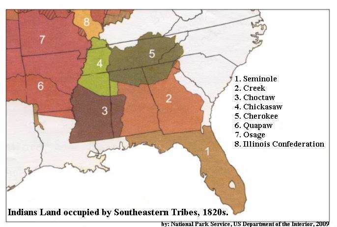
Map # 7.2 Eight Tribes of the Southeastern America, 1820
Indian Lands occupied by the Southeastern Tribes.
by National Park Service, U.S. Department of the Interior, c2009
|
 |
Map # 8.a State of Alabama, 1823
Bytes: 136,672 Date: 05-11-96 Size: 1168x1501x256
A Complete ... American Atlas of North America & South America, etc to the year 1822
By H.C. Carey & I. Lea, Phildelphia 1823.
<---
See Alabama Tribes Index
|
 |
Map # 8.g Choctaw, Arkansas Boundaries 1820~1824
Bytes: 136,672 Date: 05-11-96 Size: 1526x1135x256
(Historical Atlas of Oklahoma, Pg 21)
Map showing the boundaries after the 1824 Act of Congress which was
a clear violation of the Treaty of Doak's Stand 1820, where about 1,000
CHOCTAW moved from their ancestral homes East of the Mississippi to West
of the Mississippi in the then Arkansas Territory. This provided a new
Eastern boundary for the CHOCTAW settlements on a line extending
North from the mouth of the Little River to the Arkansas River.
|
 |
Map # 8.h Cherokee Land in the West, 1817~1828
Bytes: 136,672 Date: 05-11-96 Size: 1587x0774x256
(Historical Atlas of Oklahoma, Pg 22)
Cherokee Treaties; 1817; 1819; 1828; 1835; and 1866; Map of Western
Cherokee Nation in present-day Oklahoma and Arkansas
|
 |
Map # 8.i State Alabama, 1838
Bytes: 345,856 Date: 06-12-96 Size: 1189x1522x256
(An Illustrated Geographical, Statistical & Historical of the United States)
by T.G. Bradford, Weeks, Jordan & Co., Boston, 1838 (Microfilm from Library of Congres)
|
 |
Map # 9. Routs of Emigrating Indians, 1830~1840
<---
See: Bio. By Grant Foreman & George Nystrom/Bystrom, 1932)
Bytes: 140,165 Date: 05-11-96 Size: 3100x2466x2
Map of the 5 Civilized Tribes and their "Emigrating" routes.
1. Choctaw; 2. Cherokee; 3. Creek; 4. Chickasaw; 5. Seminole.
|
 |
Map # 11. History Map United States , 1791~1845
(A Genealogical & History Atlas of United States, Pg58)
Bytes: 179,762 Date: 02-04-96 Size: 1150x1454x2
Map East of Mississippi River, showing territories and "Cession" dates
for the period of 1791 to 1845.
|
 |
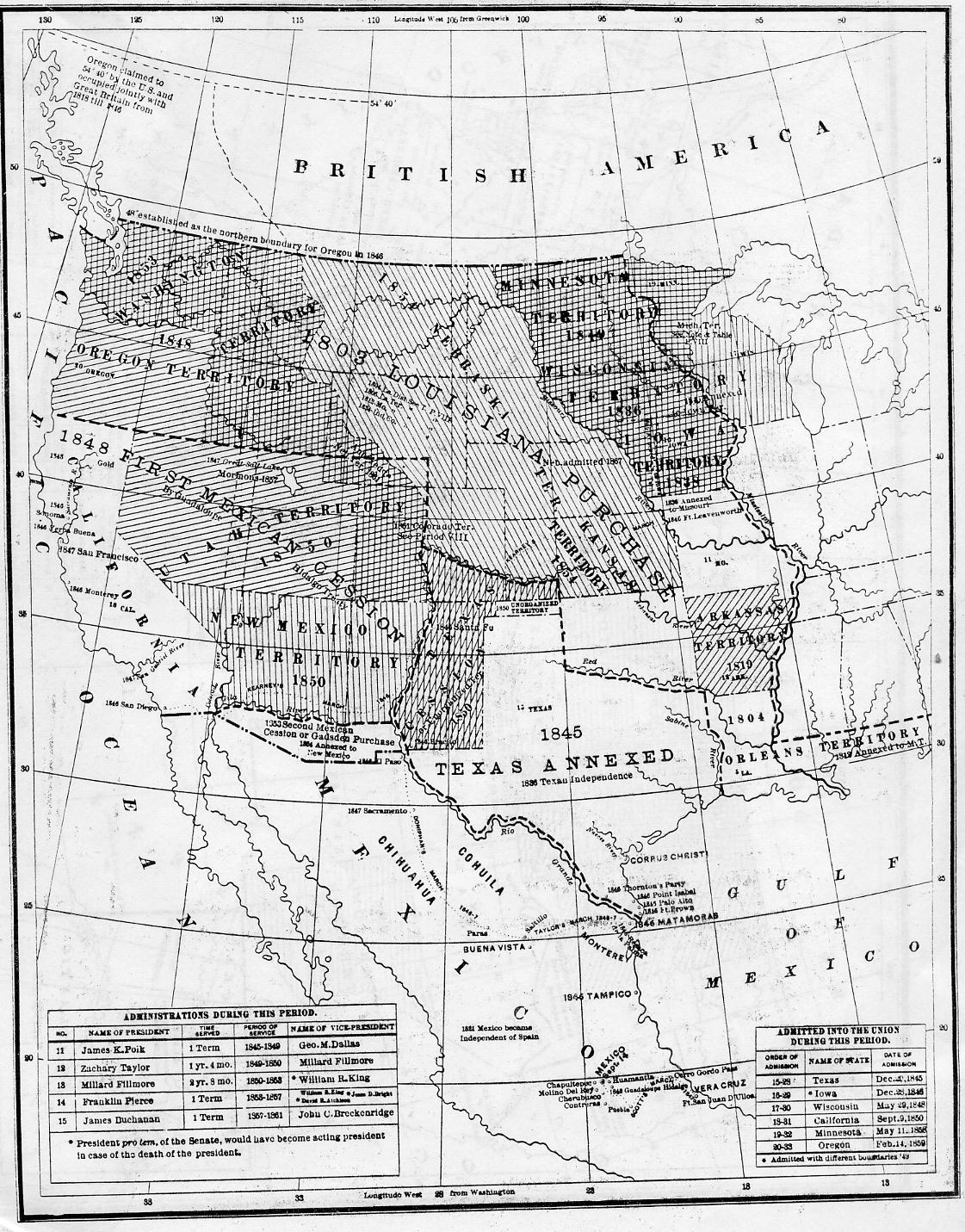
Map # 11.b History Map United States, 1845~1859
(A Genealogical & History Atlas of United States, Pg59)
Bytes: 179,762 Date: 02-04-96 Size: 1150x1454x2
Map West of Mississippi River, showing territories and "Cession" dates
for the period of 1845 to 1859.
|
 |
Map # 12.1 1884 Map of the "Territorial Limits" of the Cherokee Nation of Indians
Cessions of Land made by them to the Colonies and the United States
by Charles C. Royce
|
 |
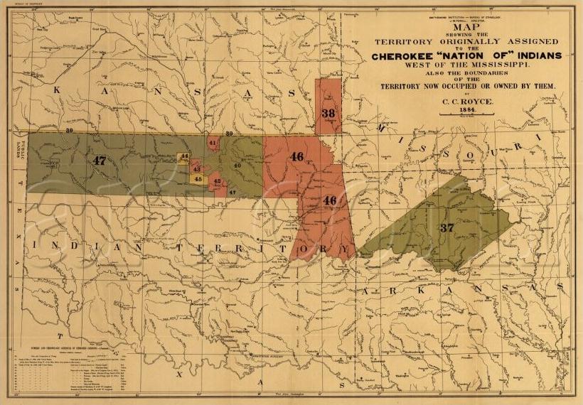
Map # 12.1 1884 Map showing the Territory Originally Assigned
to the Cherokee Nation of Indians, West of the Mississippi River
Also the boundaries of the Territory Now Occupied or Owned by them.
by: Charles C. Royce
|


 This File: MAP_INDX.TXT Vol.15
 <---E-Mail Paul R. Sarrett, Jr. Auburn, CA.
 May 11, 2011;