

|


|
|


|


|
 <---
Some Indian Territory/Oklahoma Map Index! <---
Some Indian Territory/Oklahoma Map Index!
|
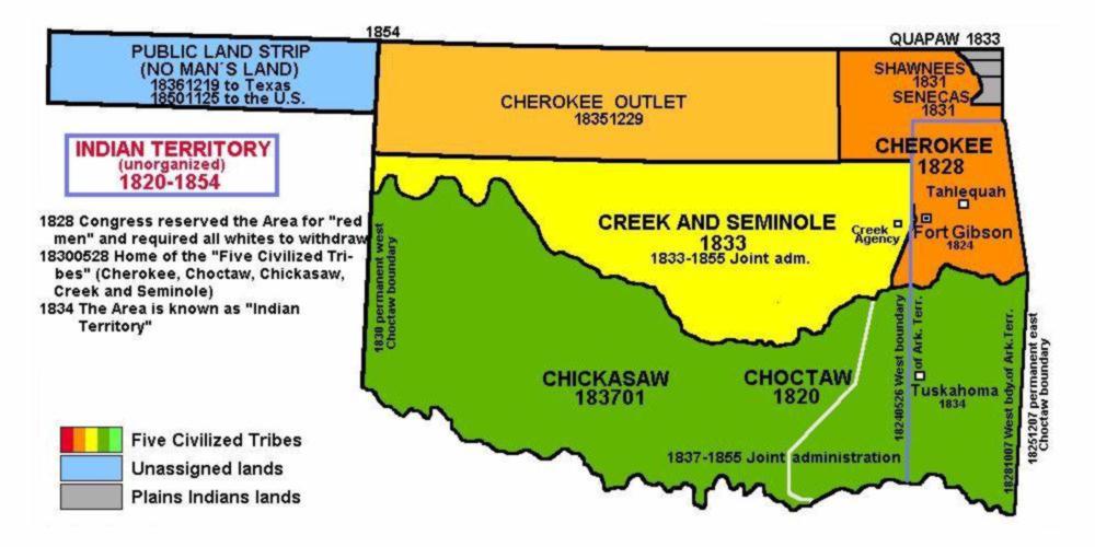
Adair Co., OK. - Cherokee Lands
was created in 1907
from  <---
"Cherokee Indian Lands"
Adair County was named after the Adair family of the Cherokee tribe.
The County Seat is <---
Stilwell, OK. 74960.
It is located at the Northeastern part of the state, on the Arkansas State border. Bounded by:
Delaware Co., OK. on the North;
<---
Crawford &
<---
Washington Co.'s AR. on the East;
<---
Sequoyah Co., OK. on the South;
with <---
Cherokee Co., OK on the West.
(First Census 1910, Clerk Co. Court has m., div., Pro., and
Civic Court records from 1907)<---
1895 Cherokee Nation-West Map!
<---
See: County Stats from Wikipedia, (the free encyclopedia) <---
"Cherokee Indian Lands"
Adair County was named after the Adair family of the Cherokee tribe.
The County Seat is <---
Stilwell, OK. 74960.
It is located at the Northeastern part of the state, on the Arkansas State border. Bounded by:
Delaware Co., OK. on the North;
<---
Crawford &
<---
Washington Co.'s AR. on the East;
<---
Sequoyah Co., OK. on the South;
with <---
Cherokee Co., OK on the West.
(First Census 1910, Clerk Co. Court has m., div., Pro., and
Civic Court records from 1907)<---
1895 Cherokee Nation-West Map!
<---
See: County Stats from Wikipedia, (the free encyclopedia) |
| SFA© Census records | 1910 | 1920 | 1930 | ||||||||||||
Atoka Co., OK. - Choctaw Lands
was created in 1907
from  <---
"Choctaw Indian Land"
The County Seat is Atoka, OK. 74525.
It is located at the Southeastern part of the state. Bounded by:
Coal Co. on the Northwest;
Pittsburg Co. on the Northeast;
Pushmataha Co. on the East;
<---
Choctaw Co. on the Southeast;
<---
Bryan Co., on the Southwest;
with Johnson Co. OK on the West.
(First Census 1910, Clerk Co. Court has m. div., Pro., and
Civic Court records from 1913)<---
1895 Choctaw Nation-West Map!
<---
See: County Stats from Wikipedia, (the free encyclopedia) <---
"Choctaw Indian Land"
The County Seat is Atoka, OK. 74525.
It is located at the Southeastern part of the state. Bounded by:
Coal Co. on the Northwest;
Pittsburg Co. on the Northeast;
Pushmataha Co. on the East;
<---
Choctaw Co. on the Southeast;
<---
Bryan Co., on the Southwest;
with Johnson Co. OK on the West.
(First Census 1910, Clerk Co. Court has m. div., Pro., and
Civic Court records from 1913)<---
1895 Choctaw Nation-West Map!
<---
See: County Stats from Wikipedia, (the free encyclopedia) |
Bryan Co. - Choctaw Lands
was created in 1907
from  <---
"Choctaw Indian Land" Named for Populist politician William Jennings Bryan.
The County Seat is Durant, OK. 74701.
It is located at the southern state line with Texas. Bounded by:
Johnston & Atoka Co.'s on the North;
<---
Choctaw Co. on the East;
Grayson & Fannin Co.'s TX on the South;
with Marshall, Co. OK on the West.
(First Census 1910, Clerk Co. Court has m. div., Pro., and
Civil Court records from 1902)<---
1895 Choctaw Nation-West Map!
<---
See: County Stats from Wikipedia, (the free encyclopedia) <---
"Choctaw Indian Land" Named for Populist politician William Jennings Bryan.
The County Seat is Durant, OK. 74701.
It is located at the southern state line with Texas. Bounded by:
Johnston & Atoka Co.'s on the North;
<---
Choctaw Co. on the East;
Grayson & Fannin Co.'s TX on the South;
with Marshall, Co. OK on the West.
(First Census 1910, Clerk Co. Court has m. div., Pro., and
Civil Court records from 1902)<---
1895 Choctaw Nation-West Map!
<---
See: County Stats from Wikipedia, (the free encyclopedia) |
Carter Co. - Chickasaw Lands
was created in 1907, from the
 <---
"Chickasaw Nation Lands".
The County Seat is Ardmore, OK. 73401. Located in the Southcentral
part of the State. Bounded by: Garvin & Murry Co.'s on the North;
Johnston & Marshall Co.'s on the East; Love Co.on the South; with
Stephens & Jefferson Co.'s on the West. <---
"Chickasaw Nation Lands".
The County Seat is Ardmore, OK. 73401. Located in the Southcentral
part of the State. Bounded by: Garvin & Murry Co.'s on the North;
Johnston & Marshall Co.'s on the East; Love Co.on the South; with
Stephens & Jefferson Co.'s on the West.(First Census, 1910; Clerk Court has m., div., Civil Court rec from 1907; Co Clerk has Land Records. Birth & Death records from 1908 are obtainable from State Dept. of Health, Division of Vitial Statistic, N.E. 10th & Stonewall, Oklahoma City, OK. 73105) <---
1895 Chickasaw Nation-West Map!
<---
See: County Stats from Wikipedia, (the free encyclopedia) |
| SFA© Census records | 1900 | 1910 | 1920 | 1930 | ||||||||||||||||||||
|
Seventh Generation! (2nd s/o <---
Lawson H. & Cynthia (BROWN) of Spartanburg Co., SC. & Chattooga Co., GA.
|
||||||||||||
| Chap. | FName | LName | b. - d. | Married | From | |||||||
| 1.2.3.1.2.2.2 | Leonidas D. | SARRATT | *1841-1924 | m. c1867, TX. Sarah E. WOLFE, | Spartanburg, Co.,SC | |||||||
|
Eighth Generation! (Children of <---
Leonidas David & Sarah E. (Wolfe) SARRATT) Spartanburg Co., SC.
| ||||||||||||
| 1.2.3.1.2.2.2.1 | Henry Ed. | SARRATT | c1867-1946 | m.. c1885, 1st TX. Mrs. Sarah J. (Standifer) WILLIAMS, 5Ch. m. c1900 2nd OK. Anna Laura ROPER, 9Ch. |
Collin Co., TX. | |||||||
| 1.2.3.1.2.2.2.2 | Manson E. | SARRATT | c1870-1926 | m.. *1898, IT. Ef-Fi-Ee May BRADLEY, 9Ch. | Collin Co., TX. | |||||||
| 1.2.3.1.2.2.2.3 | Savilla M. | SARRATT | *1876-1962 | m.. *1896, IT. Joseph M. COLSON, 7Ch. | Collin Co., TX. | |||||||
| 1.2.3.1.2.2.2.4 | Nora la M. | SARRATT | *1881-1974 | m.. *1896, IT. James L. WATKINS, 9Ch. | Collin Co., TX. | |||||||
|
Choctaw Co. - Choctaw Lands
was created in 1907 from the Choctaw Indian Lands.
The County Seat is Hugo, OK. 74743 It is located in the Southeast
part of the State, along the Texas border. Bounded by:
Atoka & Pushmataha Co.'s on the North; McCurtain Co. on the East;
Lamar & Red River Co.'s Texason the South;
with Bryan Co., OK. on the West.
(First Census 1910, Clerk Court has m., div., & Civil rec
from 1907; Co. Clerk has Land rec 1907)<---
1895 Choctaw Nation-West Map!
<---
See: County Stats from Wikipedia, (the free encyclopedia) | ||||||||||||
|
Seventh Generation! (2nd s/o <---
John B. or I. SARRATT & 2nd Wife Katie M. CASTLEBERRY
| ||||||||||||
| Chap. | FName | LName | b. - d. | Married | From | |||||||
| 1. | Samuel S. | SURRATT | *1859-1932 | m. *1881, AR. Tabith D. SMITH, 6Ch. | Faulkner Co., AR. | |||||||
|
Garvin Co. - Chickasaw Indian Lands
was created in 1907 from the Chickasaw Indian Lands.
was named for Samuel J. GARVIN, a local Chickasaw rancher, merchant and banker.
The County Seat is <---
Pauls Valley, OK. 73075 It is located in the SouthCentral part of the State. Bounded by:
� <---
McClain County (North);
� <---
Pontotoc County (East);
� Murray County (Southeast);
� Carter County (South);
� Stephens County (Southwest);
� Grady County (Northwest);
(First Census 1910, Clerk Court has m., div., & Civil rec
from 1907; Co. Clerk has Land rec 1907)<---
1895 Chickasaw Nation-West Map!
<---
See: County Stats from Wikipedia, (the free encyclopedia) |
|
Haskell Co. - Choctaw Lands
was created in 1908 from Choctaw Indians Lands.
The county is named in honor of Charles N. Haskell, who was the first governor of Oklahoma.
The County Seat is Stigler, OK. 74462. It is located in the
East Central part of the State. Bounded by Muskogee Co. on
the Northwest; Sequoyah Co. on the Northeast; Le Flore on the
East; Latimer Co. on the South; with Pittsburg Co. on the West. (First Census 1910, County Clerk has most records since 1907) <---
1895 Choctaw Nation-West Map!
<---
See: County Stats from Wikipedia, (the free encyclopedia) <---
See: Encyclopedia of Oklahoma History & Culture
|
|
Seventh Generation! (1st s/o Samuel "Holdman" R. SARRATT & Susanah Unknown of Spartanburg Dist. SC.) | ||||||||||||||||||||||||
| Chap. | FName | LName | b. - d. | Married | From | |||||||||||||||||||
| 1. | Henry | SURRATT | c1833-1898 | m. c1857, OK. I.T. Lucy EMACHAYS, 4Ch. | IT, Georgia | |||||||||||||||||||
|
Eight Generation! Children of <---
See: Henry SURRATT & Lucy EMOCHAYA, of Choctaw Nation, OK.
| ||||||||||||||||||||||||
| Chap. | FName | LName | b. - d. | Married | From | |||||||||||||||||||
| 1. | Angelina | SURRATT | c1857-18?? | Not Traced! | Choctaw N., OK. | |||||||||||||||||||
| 2. | Jeff D. | SURRATT | *1860-1900 | m. c1882, I.T. Fena McDANIELS, 2Ch. | Choctaw, N., OK. | |||||||||||||||||||
| 3. | Cooper | SURRATT | *1863-1934 | m. c1893, I.T. 1st Margaret PICKENS, 3Ch. m. c1908, IT. 2nd Prudence HOGAN, 1Ch. |
Choctaw, N., OK. | |||||||||||||||||||
| 4. | Maggie L. | SURRATT | *1865-1899 | m. *1889, I.T. Wm. Solomon HALL, 1Ch. | Choctaw, N., OK. | |||||||||||||||||||
|
<---
See: McCURTAIN Family of Choctaw Nation (West) (2nd s.o Daniel, Jr. & Hannah (COLE) McCURTAIN, MS.) Chap. |
FName |
LName |
b. - d. |
Married |
From |
1. |
Cornelius,3 |
McCURTAIN |
*1803-1860 |
m. c1827, MS Mahayia "Amy" BELVIN, 8Ch. |
Choctaw N., MS. |
| ||||||||||||
Hughes Co. - Creek Lands
was created in 1907 from Creek Indians Lands.
The county was named for W. C. HUGHES, an Oklahoma City lawyer who was a member of the Oklahoma Constitutional Convention.
The County Seat is
<---
Holdenville, OK. 74848. It is located in the South Central part of the State. Bounded by
� Okfuskee County (North);
� <---
McIntosh Countyrtheast);
� Pittsburg County (East);
� Coal County (South);
� <---
Pontotoc County (Southwest);
� Seminole County (West);
(First Census 1910, County Clerk has most records since 1907)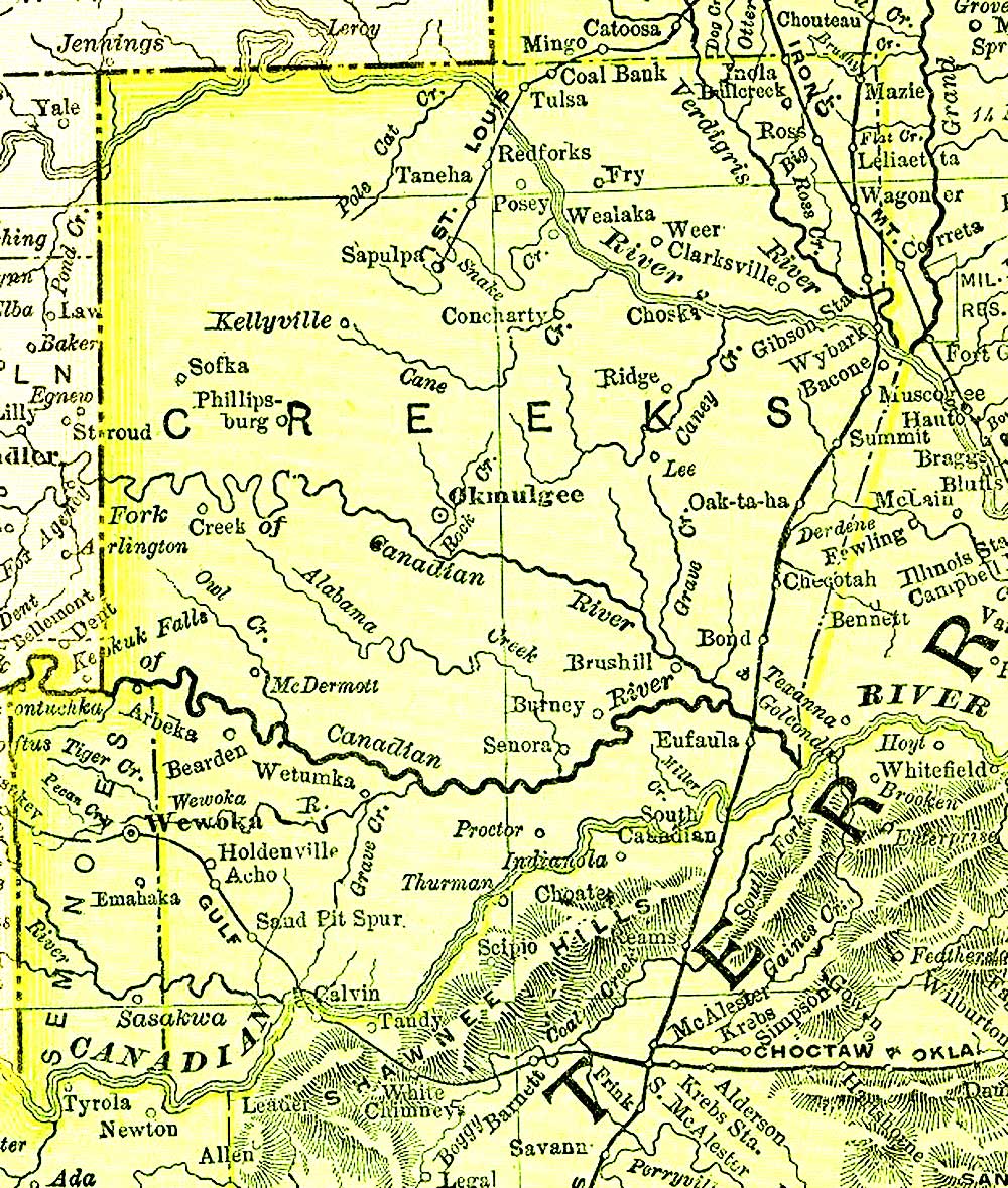 <---
1895 Creek Nation-West Map!
<---
See: County Stats from Wikipedia, (the free encyclopedia) <---
See: Encyclopedia of Oklahoma History & Culture <---
1895 Creek Nation-West Map!
<---
See: County Stats from Wikipedia, (the free encyclopedia) <---
See: Encyclopedia of Oklahoma History & Culture
|
|
Jackson Co. - Choctaw Lands
was created in 1907 from Greer County.
The County Seat is Altus, OK. 73521. It is located in the
Western part of the State. Bounded by
� Greer County (North);
� Kiowa County (Northeast);
� <---
Tillman County (East);
� Wilbarger County, Texas (South);
� Hardeman County, Texas (Southwest);
� Harmon County (West); (First Census 1910, Curcit Clerk has m., Div., Probate, & Civil Court Rec. from 1907 County Clerk has Land records) <---
See: County Stats from Wikipedia, (the free encyclopedia) <---
See: Encyclopedia of Oklahoma History & Culture
|
|
Seventh Generation! (3rd Son of: <---
See: Charles C. SURRATT & Frances Jane DeVAULT, of McNairy Co., Tenn. | ||||||||||||
| Chap. | FName | LName | b. - d. | Married | From | |||||||
| 5. | Duke C. | SURRATT | *1879-1973 | m. *1898, TN. Cora L. BAUCUM, | McNairy Co., TN. | |||||||
|
Eight Generation! Children of <---
See: Duke C. SURRATT & Cora L. BAUCUM, of McNairy Co., Tenn.
| ||||||||||||
| 1. 1st Son: | William "Earl" |
SURRATT | TN. b. *1899 ~ d. 1958 OK. | m. *1923, Helen V. SUTHERLAND, | 2Ch | |||||||
| 2. 1st Son: | Charlies "Burlie" |
SURRATT | TN. b. *1901 ~ d. 1979 TX. | m. *1922, Bertie UNDERWOOD, | 2Ch | |||||||
| 3. 3rd Son: | Julius Eason |
SURRATT | TN. b. *1904 ~ d. 1936 OK. | m. *1924, Glenna T. ELDER, | 1Ch | |||||||
| 3. Only Dau: | Ila Jane |
SURRATT | TN. b. *1911 ~ d. 2006 NM. | m. *1937, Harry Albert GRAHS, Sr. | 2Ch | |||||||
|
McClain Co. - Chickasaw Indians Lands
was created in 1907 from Chickasaw Indians Lands.
It was named for Charles M. McClain, an Oklahoma constitutional convention attendee.
The County Seat is
<---
Purcell, OK. 73080. It is located in the
Southern Central part of the State. Bounded by:
� Cleveland County (North);
� Pottawatomie County (Northeast);
� Pontotoc County (East);
� Garvin County (South);
� Grady County (West);
(First Census 1910, Curcit Clerk has m., Div., Probate, & Civil Court Rec. from 1907
County Clerk has Land records)<---
See: County Stats from Wikipedia, (the free encyclopedia) <---
See: Encyclopedia of Oklahoma History & Culture <---
See: 1895 CHICKASAW INDIAN NATION<---
See: Township Map, McClain Co., Oklahoma [Maps 'N' More] |
|
Marshall Co. - Chickasaw Lands
was created in 1907 from the former Pickens County of the Chickasaw Nation Lands.
It was named to honor the maiden name of the mother of George HENSHAW, a member of the 1906 Oklahoma Constitutional Convention.
The County Seat is
<---
Madill, OK. 73446.
It is located in the south central border of the State. Bounded by
� Johnston County (North);
� Bryan County (East);
� <---
Grayson County, Texas (South);
� Love County (West);
� Carter County (Northwest); (First Census 1910, Curcit Clerk has m., Div., Probate, & Civil Court Rec. from 1907 County Clerk has Land records) <---
See: County Stats from Wikipedia, (the free encyclopedia) <---
See: Encyclopedia of Oklahoma History & Culture |
|
Osage Co. - Osage Lands
was created 1907 from the Osage Indian Lands.
The County Seat is Pawhuska, OK. 74056. It is located in the
Northeast part of the State. Bounded by Chautauqua Co., KS.
on the North; Washington & Tulsa Co.'s on the East; Creek
Co. on the South; Pawnee & Kay Co.'s on the West.
(1st Census 1910, County Clerk has land rec from 1907<---
See: 1920 Census;
<---
See: 1930 Census;)<---
See: County Stats from Wikipedia, (the free encyclopedia) <---
See: Encyclopedia of Oklahoma History & Culture
|
|
Seventh Generation! 3rd Son of <---
John,16 SURRETT & Kizziah WORLEY, of Buncombe, North Carolina |
|||||
| Chap. | FName | LName | b. - d. | Married | From |
| 1. | Henry A. | SURRETT | *1830-1922 | m. c1858 1) GA. M. Ruth MIZE, 1Ch. m. *1869 2) MO. Susan E. SUMMERS, 14Ch. |
Buncombe Co., NC. |
Eight Generation! Child of <---
Henry A. SARRATT & 1st Wife M. Ruth MIZE, of Osage Co., Okla.
|
| 8.01 | Arthur L. | SURRETT | *1830-1922 | m. *1887 GA. Martha Lou RAMEY, 6Ch. | Walker Co., GA. |
Eight Generation! Children of <---
See: Henry A. SARRATT & 2nd Wife Susan E. SUMMERS, 14Ch, of Osage Co., Okla.
|
|
Eight Generation! 1st Son of <---
See: James B. SURRITTE & Martha J. GARRETT, of Pottersville, Howell Co. MO.
|
|||||
| Chap. | FName | LName | b. - d. | Married | From |
| 8.1 | George W. | SURRITTE | 1890-1964 | m. *1909 MO. Virgie D. CALLAHAN, 12Ch. | Howell Co., MO. |
|
Pontotoc Co. - Chickasaw Indian Lands
was created 1907 from the Chickasaw Indian Lands.
It was named for a historic Chickasaw tribal area in Mississippi, where there is also a county named Pontotoc.
The County Seat is <---
Ada, OK. 74820. It is located in the SouthCentral part of the State. Bounded by:
� Seminole County (North);
<---
� Hughes County (Northeast);
� Coal County (Southeast);
� Johnston County (South);
� Murray County (Southwest);
� Garvin County (West);
<---
� McClain County (Northwest);
Pottawatomie County (Northwest)
(1st Census 1910, County Clerk has land rec from 1907<---
See: County Stats from Wikipedia, (the free encyclopedia) <---
See: Encyclopedia of Oklahoma History & Culture
|
|
Pushmataha Co. - Choctaw Lands
was created in 1907, from the Choctaw Indian Lands.
The County Seat
<---
Antlers, OK., 73523. It is located in the Southeastern
part of the State. Bounded by:
Latimer Co., on the North;
LeFore Co., on the Northeast; <---
McCurtian Co., on the West;
<---
Choctaw Co., OK. on the South;
<---
Lamar Co., TX. (south of Choctaw Co., OK)
Atoka Co. on the West. Cities & Towns: Abbott; Adel; Albion; Antlers; Belzoni; Clayton; Cloudy; Cohn; Corinne; Council House; Crum Creek; Darwin; Dela; Dunbar; Ethel; Eubanks; Fewell; Finley; Gee; Honobia; Johns Valley; Jumbo; Kellond; Kiamichi; Kosoma; Lyceum; Miller; Moyers; Nashoba; Nolia; Oleta; Rattan; Rodney; Sardis; Snow; Sobol; Spencerville; Stanley; Tuskahoma; Wilson; Zoraya; (1st Census 1910)
1895 County Co., Map!
<---
See: County Stats from Wikipedia, (the free encyclopedia) | ||||||||||||
|
Third Generation!
<---
Sons of: Cicero Green,2 & Sarah Jane (Clay) SURRETT) GrandSons of: <---
Wm. Sanford & 1st w Mary "Leney" (Prator) SARRETT <--Not Proven!
| ||||||||||||
| Chap. | FName | LName | b. - d. | Married | From | |||||||
| 1. | William R. | SURRETT | c1855-1926 | m. *1874, AL. Emma Emily BOLTON, 3Ch. | DeKalb Co., GA. | |||||||
| 6. | James O. | SURRETT | c1867-1918 | m. 1) 26 Apr 1884, AL. LuElla L. POTTS, 6Ch. m. 2) 01 Jun 1902, TX. Mary RIKARD, 1Ch. |
Floyd Co., GA. |
<---
Letter from Terry J. MARTIN - Jul 31, 2000;
Re: James Oscar and LuElla (Potts) SURRETT Family |
||||||
|
Sequoyah Co. - Cherokee Lands
was created in 1907, from Cherokee Lands.
It was named after Sequoyah, who created the Cherokee syllabary.
The County Seat is Sallisaw, OK. 74955. It is located in
the Northeastern part of the State. Bounded by:
Cherokee and <---
Adair Co.'s on the North;
With <---
Crawford Co., AR. on the East;
LaFlore &
<---
Haskell Co.'s on the South; and
Muskogee Co., on the West. (First Census 1910, Co. Clerk has m., div, pro & Court rec from 1907) <---
1895 Cherokee Nation-West Map!
 <---
1915 Sequoyah Co. Twp. Map! <---
1915 Sequoyah Co. Twp. Map! 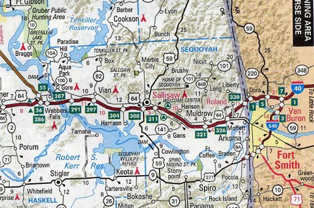 <---
1970 Sequoyah Co. Map!
<---
See: County Stats from Wikipedia, (the free encyclopedia) <---
1970 Sequoyah Co. Map!
<---
See: County Stats from Wikipedia, (the free encyclopedia) |
|
Seventh Generation! 3rd Son of: <---
See: John,15 SERATT & 2nd Wife: Nancy Lane LANE "The Bell Maker"
|
|||||
| Chap. | FName | LName | b. - d. | Married | From |
| 1.3.3.08.17. | Joseph S. | SERATT | *1857-1934 | m. *1878 AR. Phebe R. BELDEN, 7Ch. | Adair Co., MO. |
Eighth Generation! Children of <---
Joseph S. SERATT & Phebe R. BELDEN 3rd Son of the "The Bell Maker" & 2nd Wife!
1.3.3.08.17.1 |
Orpha A. |
SERATT |
*1878-1914 |
m. c1898 IT.West John B. MOTEN, 7Ch. |
Washingron Co., AR |
1.3.3.08.17.2 |
Charles A. |
SERATT |
*1883-1969 |
m. c1811 IT.West Jo-An-Na WINTERS, 5Ch. |
Washingron Co., AR |
1.3.3.08.17.3 |
John F. |
SERATT |
*1885-1954 |
m. *1908 IT.West Flora A. EWING, 5Ch. |
Crawford Co., AR |
1.3.3.08.17.4 |
Samuel W. |
SERATT |
*1887-1923 |
m. *1911 IT.West 1st Lucy SEABOLT, 2Ch. |
m. c1921 OK., Ellen BURGESS, 2Ch. Crawford Co., AR |
1.3.3.08.17.5 |
Martha E. |
SERATT |
*1889-1980 |
m. *1916 OK. D. "John" BUNYARD, 2Ch. |
Crawford Co., AR |
1.3.3.08.17.6 |
Stella M. |
SERATT |
*1893-1983 |
m. *1913 OK., Fred O. NIX, 2Ch. |
Crawford Co., AR |
1.3.3.08.17.7 |
Luvenia I. |
SERATT |
*1895-1984 |
m. *1915 OK., Wm. V. KEEN, 2Ch. |
Crawford Co., AR |
|
|
Tillman Co. - Comanche Lands
was created in 1907, from Comanche Indian Lands;
Was named for Senator Benjamin Tillman of South Carolina. It had previously been part of Comanche County, Oklahoma Territory. In 1910 and 1924 portions of Kiowa County were added to the north side of the county.
The County Seat is Frederick, OK. 73542. It is located in the
Southwestern part of the State. It is Bounded by
Kiowa & Comanche Co's on the North;
Cotton Co., on the East;
Wilbarger & Wichita Co's Texas on the South;
<---
Jackson Co., OK. on the West. (First Census 1910, Co. Clerk has m., div, pro & Court rec from 1907) <---
See: County Stats from Wikipedia, (the free encyclopedia) <---
Encyclopedia of Oklahoma History & Culture
|
|
Seventh Generation! (3rd Son of: <---
Washington Lafayette SARRETT & 2nd Wife: Louisa HOLLINGSWORTH, of Benton Co., Tenn.
|
||||||||||||
| Chap. | FName | LName | b. - d. | Married | From | |||||||
| 9. | Samuel W. | SARRETT | *1867-1953 | m. c1889 TN. 1st Louisa E. VICK, 8Ch. m. *1905 OK. 2nd Martha I. CUNNINGHAM, 3Ch. |
Benton Co., TN. | |||||||
|
Tulsa Co. - Creek Indians Lands
was created in 1907, from Creek Indian Lands;
It was named after the previously established city of Tulsa.
Before statehood, the area was part of both the
Creek Nation and the Cherokee Nation in Indian Territory
The County Seat is
<---
Tulsa, OK. 74103. It is located in the
Northwestern part of the State. It is Bounded by:
� Washington County (North);
� Rogers County (Northeast);
� Wagoner County (Southeast);
� Okmulgee County (South);
� Creek County (West);
� Pawnee County & Osage County (northwest);
(First Census 1910, Co. Clerk has m., div, pro & Court rec from 1907)<---
See: County Stats from Wikipedia, (the free encyclopedia) <---
Encyclopedia of Oklahoma History & Culture
|
 These records are part of the "Genealogy Computer Package" *** PC-PROFILE *** Volume - II.
Sarratt/Sarrett/Surratt Family Profile©
Compiled and self Published in Oct. 31, 1989 by Paul R. Sarrett, Jr. with
the assistance of my late mother
Mrs. M. Lucille (WILSON) SARRETT (1917-1987)
These 1989 "Work-Books" were compiled by listing the various families, born, married, died, and a history of that family branch.
In 1996 I started "Up-Loading" this material on the now called SFA© Series...prs
These records are part of the "Genealogy Computer Package" *** PC-PROFILE *** Volume - II.
Sarratt/Sarrett/Surratt Family Profile©
Compiled and self Published in Oct. 31, 1989 by Paul R. Sarrett, Jr. with
the assistance of my late mother
Mrs. M. Lucille (WILSON) SARRETT (1917-1987)
These 1989 "Work-Books" were compiled by listing the various families, born, married, died, and a history of that family branch.
In 1996 I started "Up-Loading" this material on the now called SFA© Series...prs
|
 Paul R. Sarrett, Jr., President of SFA©
 Created: Dec. 01, 1996; Dec 16, 2000; Nov 10, 2008;
 Jul 18, 2011;