
|
ROSS COUNTY'S BOUNDARIES
|
|
Prior to Ohio's statehood, 01 Mar 1803, Ross County was a governmental division of the Northwest Territory, and from 1800 until 1803, was the home of the territorial capital: Chillicothe -- which later became the capital of Ohio. The Northwest Territory is outlined above in brown; the resulting states carved from this vast area are delineated and identified in magenta.
Through the next series of pages, you can take a virtual tour through Ross County's formation and boundary changes over the course of her first few decades of existence.
To begin our tour, let's start with a map of Ohio as it presently exists. In this way, you may see (relative to other counties) how Ross County presently stands, and how it was the parent of a very large part of Southern Ohio.
On the subsequent map pages, the border of Ross County at the time on each page is illustrated in red, while the underlying gridwork shows the present boundaries (in black) for point-of-reference. Ross County's present size is illustrated in gold for comparison.
Ohio In The Present
Geographical Map Of Ohio:
Present Day Location of Ross County
Ohio's Regional Neighbors Michigan Canada Indiana Ohio Map Courtesy of:
Pennsylvania Kentucky West Virginia
Ross County: Pre-statehood

By the latter 1790s, Ohio was fast becoming the "great gateway westward" from locations along the eastern seaboard. From New England, Pennsylvania, Virginia and the Carolinas, families migrated along the major water routes (primarily the Ohio, Muskingum, Scioto and Great Miami rivers) to trading locations along the southern frontier of the Northwest Territory: Marietta, Gallipolis, Portsmouth and Cincinnati; and in the opposite direction into the interior of the Northwest Territory.
The map above illustrates the major geopolitical divisions in existence in the 1790s into which these families moved. Now let's look at how Ross County began.
Ross County: 1797
Prior to Ross County's existence, its territory was a part of Adams County, which was formed 10 Jul 1797 by proclamation of Governor Saint Clair, being then one of the four counties into which the Northwest Territory was divided.
The first settlement within the Virginia military tract, from which Adams County was created, and the only one between the Scioto and Little Miami Rivers until after the treaty of Greenville in 1795, was made in this county at Manchester by the (then) Colonel (and later General) Nathaniel Massie.
At the time that Adams County was created, from land taken from Hamilton and Washington Counties, the total area encompassed 6,500 square miles - roughly 15% of the entire future state of Ohio - as illustrated in the map above.
Ross County: 1798

Ross County was formed by proclamation of Gov. St. Clair 20 Aug 1798, being the sixth county formed in the Northwestern Territory. Its original limits were very extensive. It was named from the Hon. James Ross, of Allegheny County PA, who at that time was the unsuccessful candidate of the Federalists for the office of governor of that State.
At the time that Ross County was created, from land taken from Adams, Hamilton and Washington Counties, the total area encompassed 6,700 square miles - roughly 16% of the entire future state of Ohio.
Ross County: 1800

Ross County: 09 Dec 1800
At the creation of Fairfield County, Ross County lost its northeastern corner, totaling 1,150 square miles being ceded to the new county. Upon Ohio's admittance to the United States of America as the seventeenth state, on 01 Mar 1803, Ross County contained 5,650 square miles of real estate, as illustrated above.
Ross County: 1803
With the expansion of the population northward from Chillicothe, Franklinton, the county seat of newly-created Franklin County (30 Apr 1803), became a focal-point for migration into the interior of Ohio. Franklin County acquired 2,150 square miles from the northern section of Ross County, leaving 3,400 square miles to her parent.
Immediately on the heels of Franklin County's creation, Greene County Ohio was formed from the northwestern territory of Ross County, 01 May 1803. With the loss of only 650 square miles, Ross County retained 2,750 square miles within its borders.
Ohio's county development at the time of admittance into the union is illustrated in the map directly above. Chillicothe was the seat of Ohio's government from 1803-1810 and 1812-1816. Franklinton, later renamed to Columbus, became the official state capital in 1816. From 1810-1812, Zanesville, Fairfield County, was the location of the state capital.
The purple dotted line illustrates the northern boundary of the Treaty of Greeneville (1795). The red line running from Aberdeen, Adams County Ohio, and the eastern border of Ohio (crossing the Ohio River at Wheeling [West] Virginia, is Zane's Trace.
Ebenezer Zane laid out a road (known as Zane's Trace; illustrated above in red) from Wheeling, Virginia (WV), through Ohio, to Limestone (now called Maysville), Kentucky. Zane's Trace opened in 1797, and towns along the route included (southwest to northeast) West Union and Peebles (Adams Co), Sinking Spring (Highland Co), Chillicothe (Ross Co), Tarlton (Pickaway Co), Lancaster (Fairfield Co), Zanesville (Muskingum Co), Cambridge (Guernsey Co), St. Clairsville (Belmont Co), and Wheeling (Ohio Co) WV. Zane's Trace provided the best means of overland travel through southern and eastern Ohio until the advent of the railway system.
Ross County: 1805
Highland County, the next county to be carved from Ross's terrain, claimed 900 square miles from her ancestral parent, leaving 1,850 square miles to Ross. With the western border of Ross County established, no further changes take place between the northern and southern termini between these two counties.
Ross County: 1810
Focusing our attention to the north, on 01 Mar 1810, both Fayette County and Pickaway County acquire land from Ross County, totaling 410 square miles. Ross County's area now contains 1,440 square miles - 21% of her original property has so far been delegated to neighboring counties. All of Ross's western frontier, and now that to the north, is firmly fixed.
Ross County: 1815
Acquiescing to the demands of a growing population, the state government forms Pike County from land taken from Adams, Scioto and Ross Counties. Ross transfers 360 square miles of its southern territory to the new county, leaving 1,080 square miles. Ross's southern border is now established.
Ross County: 1816
With the explosion of Southern Ohio's population (reaching over 50,000 in the Lower Scioto Valley by 1820), migrations between counties became commonplace as new settlers arrived and old settlers sought different vistas. A large migration of families moved from southern Adams County into western Jackson County during the 1810-1815 period, and at the request of the local citizenry, the State government created Jackson County (to the southeast of Ross) from land taken from Ross, Gallia, Pike and Scioto Counties. Ross's contribution totaled 160 square miles, leaving 920 square miles (above). This is the first acquisition of Ross land by Jackson County.
By 01 Mar 1818, upon the creation of Hocking County to the northeast, and through another land transfer to northern Jackson County, Ross's total area encompassed 690 square miles. Ross's southeastern corner is determined.
Ross County: 1834

Ross County: 1850 - Present
With the creation of Vinton County on 01 Apr 1850, Ross County lost its final section of land with the transfer of Eagle Township to the newly-formed county. With this transfer, Ross County's frontier is finally, and firmly, determined, and remains fixed through the present. Ross's final land summary equals 690 square miles, placing it as the third-largest county in the state of Ohio.
Ross County Today
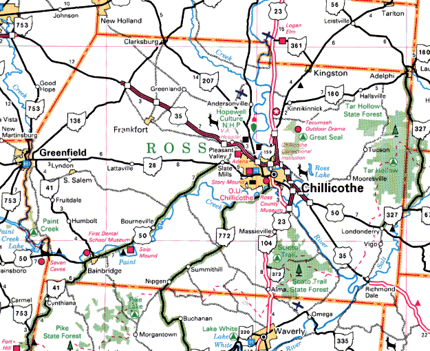
Today, Ross County and its citizens enjoy the variety of all life has to offer within its borders: from the rugged Appalachian foothills to the south and east, to the plains-like farmland of the west and north; water in abundance through the Scioto River and its plentiful tributaries; cultural and intellectual arenas from the prehistoric to the present; recreation facilities in abundance; major thoroughfares adding to the healthy economic climate; and city life to rural comfort. From within Ross's borders, both past and present, the development of Ohio's government, economy, history and prosperity can find its roots.
