Cemeteries of Gilead Township, Morrow County, OH
 |
|
Morrow CountyChapter of the Ohio Genealogical Society |
|
 |
Morrow County, Ohio
Gilead Township Cemeteries
Most of the cemetery names and locations were obtained from the results of a federally funded project in the 1930's, known as the "WPA Veterans Grave Registration Project". It was conducted in cooperation with the American Legion to identify the names of all veterans of the armed services buried in Morrow County and to locate their graves. A copy of the WPA survey is in the Recorder's office in the Morrow County Courthouse, Mount Gilead, Ohio. In addition, over the years, volunteers from the Morrow County Genealogical Society have physically walked through every known cemetery area and, in most cases, were able to record the tombstone inscriptions and locations.
GPS coordinates, where listed, are from the USGS Geographic Names Information Service (GNIS) at http://geonames.usgs.gov
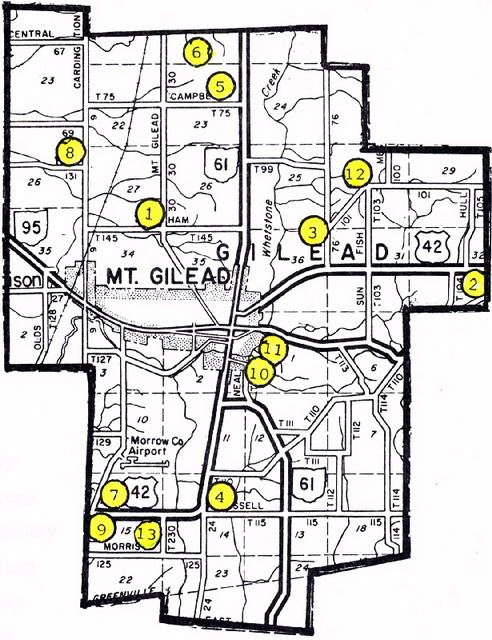
1. Bingham Cemetery
GPS Coordinates: Latitude 40.5661707 and Longitude -82.84018.
Located in Section 25, Township 14, Range 21. .01 Acre. 500 feet SE of intersection of County Road 30 and Township Road 145, one mile north of Mt. Gilead. (Was Bingham & Carpenter's Orchard.) Contains eight Bingham stones and four Carpenter stones. Read by Homer E. Hollingsworth in 1993.
2. Bryn Zion Cemetery
GPS Coordinates: Latitude 40.5567264 and longitude -82.7682327
Located in Section 32, Township 18, Range 20. Twelve acres on the west side of Bryn Zion Road (County Road 240), about 500 feet south of US42; bordered on the north and west by a small stream, and on the south by Morrow County Road 110. It is well kept. Deed Records from Bryn Zion Church Trustees (William Jones, John T. Winget, James Shipman) to Trustees of Gilead, Franklin and Congress Townships Cemetery = five acres & 26 rods; 22 April 1893 [Deed Book 47, Page 251] Read by E. Merwin and George & Velva Morgan, 1990.
3. County Home Cemetery
GPS Coordinates: Latitude 40.5653374 and Longitude -82.8076788
Located in Section 36, Township 14, Range 21. One Acre. Mt. Gilead-West Point Road (cr76) and Mt. Gilead-Williamsport Road (CR 101) 1/2 mile north of US42; NE of Mt. Gilead. No stones remaining as of cemetery survey in 1995.
4. Friends Church/Quakerdom Cemetery
GPS Coordinates: Latitude 40.5167269 and Longitude -82.8354570
Located in Section 14, Township 13, Range 21. Three acres. Russell Road (County Road 115) and Worthington-New Haven Road (CR24) at bend in US42, 2-1/4 miles south of Mt. Gilead. Cemetery relocated from Mt. Gilead.
5. Hershner Cemetery
GPS Coordinates: This cemetery is not listed on the USGS site.
Located in Section 14, Township 14, Range 21. .95 Acres. Campbell Road (TR75) and Mt. Gilead-Galion Road (SR61) 2.75 miles north of Mt. Gilead. This cemetery is now (before 1995) abandoned but some of the old stones still stand in the woods.
6. Hetrick Cemetery
GPS Coordinates: This cemetery is not listed on the USGS site.
Located in Section 14, Township 14, Range 21. .002 Acres. Marion-Williamsport Road (TR 61)and Mt. Gilead-Galion Road (CR 30) 3.5 miles north of Mt. Gilead. Information provided by Mrs. Walter Rinehart, Sr., of Galion, OH.
7. Hexite-Hexsite-Hicksite Cemetery
GPS Coordinates: Latitude 40.5170046 and Longitude -82.8549022
Located in Section 5, Township 13, Range 21. .21 Acres. Mt. Gilead-Cardington Road (TR126) and USR 42 3-1/4 miles south and west of Mt. Gilead. On 1961 U.S. Coast & Geodesic Survey Map, Mt. Gilead Quandrant, location is listed as Section 15, Township 65, Range 21; approximately 200' north of US 42 and 50' west of Center Line. That location would be slightly east of where the GNIS GPS map marker is. According to Charles Mosher, 30 December 1988: Cemetery is located on the former Charley Sadler farm, near the line fence. No stones.
8. Kelly Cemetery
GPS Coordinates: This cemetery is not listed on the USGS site.
Located in Section 26, Township 5, Range 17. .02 Acres. Cardington-Edison-Iberia Road (CR9) and Tabor Road (CR 131) 1.5 miles north of Edison. No stones.
9. Mosher/Mozier Cemetery
GPS Coordinates: Latitude 40.5156158 and Longitude -82.8612913
Located in Section 15, Township 13, Range 21. .5 Acres. US42 and Mt. Gilead-Cardington Road (TR 126). Copied by Daniel L. Rhodebeck 23 Oct 1982.
10. Old Presbyterian Cemetery
GPS Coordinates: This cemetery is not listed on the USGS site.
Located in Mt. Gilead at rear of 112 S. Main Street (Snyder Funeral Home location as of 2009). One acre.
11. River Cliff Cemetery
Located at east edge of Mt. Gilead at Marion Street and SR95. 27 Acres. "River Cliff" was adopted as the official name of the cemetery at Mount Gilead at a meeting of the cemetery trustees, on May 12, 1898, at the suggestion of C. C. Wheeler, a trustee. [Union Register, 18 May 1898] Deed records date from 1863; also time-keeper's books.
12. Sunfish Cemetery
GPS Coordinates: Latitude 40.5739484 and Longitude -82.7954562
Located in Section 30, Township 18, Range 20. .5 Acres. On north side of Mt. Glead-Williamsport Road (CR 101) at Sunfish Road (TR 103). 2.75 miles northeast of Mt. Gilead. Only a few stones left [before 1995] and most of them illegible. Read by G. S. Morgan.
13. Union Cemetery
GPS Coordinates: Latitude 40.5158935 and Longitude -82.8426795.
Located in Section 14, Township 13, Range 21.
Located at US 42 and Furbey Road (TR 230). 1.5 Acres. Two miles south of Mt. Gilead. Read by E. Merwin and George & Velva Morgan 1990.
Return to the Home Page
Copyright 2012 by the Morrow County Genealogical Society - All rights reserved.
This site may be freely linked to but not duplicated in any fashion without written consent. |