
(Click On Image For More Maps)
- Caswell County, North Carolina
- Located In NC Piedmont
|
(Click On Image For More Maps) |
|
North Carolina is noted for its three distinct geographical regions, the Coastal Plain, the Piedmont, and the Mountains. Each has its own characteristics and in may respects these geographical differences have played significant roles in the development of the state. The rich soft soil, free of rocks, and the course of the rivers seems to have predetermined that the Coastal Plain, the easternmost region, would be devoted to agriculture with large farms. The rolling hills of the Piedmont, the swift and shallow streams, and the rocky red clay soil marked that region for small farms (because the soil was more difficult to till). The steep slopes of the mountains in the western part of the state and the nearly inaccessible fertile valley land attracted still a different sort of settler, one who did not mind an isolated life on a small plot of ground.
Caswell County lies in the Piedmont section slightly west of the mid-point of the state. It is in the northern half of the state, the county's northern boundary being a part of the North Carolina-Virginia state line. There are nine counties along this boundary that are east of Caswell and five that are west. Caswell is bounded on the east by Person County which was once the eastern half of Caswell, on the south by Orange and Alamance, and on the west by Rockingham. Its northern neighbors in Virginia are Pittsylvania and Halifax counties.
In shape Caswell County is almost a square, each of its sides being about twenty miles in length. It contains 278,100 acres or 400 square miles. In general the slope of the land in the county is to the northeast and the north, except for a small area in the southwestern corner which slopes toward the south. One of the highest elevations in the county, 775 feet above sea level is near Matkins in the southwestern corner, diagonally across the county, is 495. In some areas the changes in elevation in a short distance is great. The altitude of Park Springs is 606 while about two and a quarter miles east across Moon's Creek the altitude is about 524. The bed of the creek, however, is at least 100 feet lower than the top of the ridges on either side. Nearly all of the creeks in the western half of the county flow through depressions equally as low. It is in this part of the county that the highest elevations occur, particularly around Ashland and Quick, and along the southern border around Jericho, Baynes, Corbetts, Prospect Hill, and Ridgeville. The lowest elevations occur along the Dan River in the northern part of the county.
Roads throughout the county, most of which were first used in the eighteenth century by settlers moving into North Carolina from the north, follow high ground, turning and curving with the terrain. These roads probably follow the trails of Indians or of animals that roamed the region before the first European arrived. Land slopes gently to the left and right from almost every road except as the road approaches and crosses a stream and there are interesting views of the countryside in all directions. In what is now western Caswell, William Byrd in 1728 while surveying the North Carolina-Virginia boundary, mounted the highest hill encountered to that time and from it "made the first discovery of the mountains on the northwest of our course. They seemed to lie off at a vast distance and looked like ranges of blue clouds rising one above another."
With respect to soil conditions, the census taker in Caswell County in 1860 added several paragraphs of his own comments and observations after he had completed filling in the forms provided for his use. "The soil in this subdivision, " he wrote, "is not very deep, but very light and free." As he observed, it was the kind of soil ideally suited to the growth of tobacco. In 1908 the United States Department of Agriculture and the North Carolina Department of Agriculture joined forces in the production of a survey of the soil of Caswell County. The soil specialists described the surface of the county as consisting of a high upland plateau, badly dissected and eroded in many places, presenting undulating, rolling, and hilly surface features throughout. Some of the more level and undulating areas which they described were around Jericho, Baynes, Frogsboro, Semora, Cherry Grove, and Cobbs Shops. Large areas of gently rolling land were observed between the streams; this land, running in a southwest and northeast direction across the county, they described as "admirably suited for farming purposes." It becomes rolling and hilly as the streams are approached. The roughest areas are those along Country Line Creek.
In most parts of the county the streams have cut deep, narrow valleys, and bordering them in many places are steep hillsides, which have become badly eroded and gullied. Most of the streams are very swift, and because of the surrounding rolling countryside, rainfall rushes rapidly into them and they become swollen soon after a heavy rain. These creeks provided good sites for mills, and grist mills to grind corn and wheat have existed on many of the creeks in the county at one time or another. The 1908 survey, perhaps in anticipation of later development, pointed out that a large amount of power could be generated on the Dan River near Milton. Hyco Lake in northeastern Caswell County and northwestern Person County was formed on the Hyco River in 1964 when the Carolina Power and Light Company constructed a dam in connection with an electric power generating plant. The lake is approximately ten miles long and covers 7,750 acres.
Boy Scout Lake Farmer Lake Hyco Lake Wildwood Lake. For an interesting 1928 newspaper article see Wildwood Fishing Club.
Milton and Sutherlin Narrow Gauge Railway Norfolk, Franklin, and Danville Railroad Southern Railroad
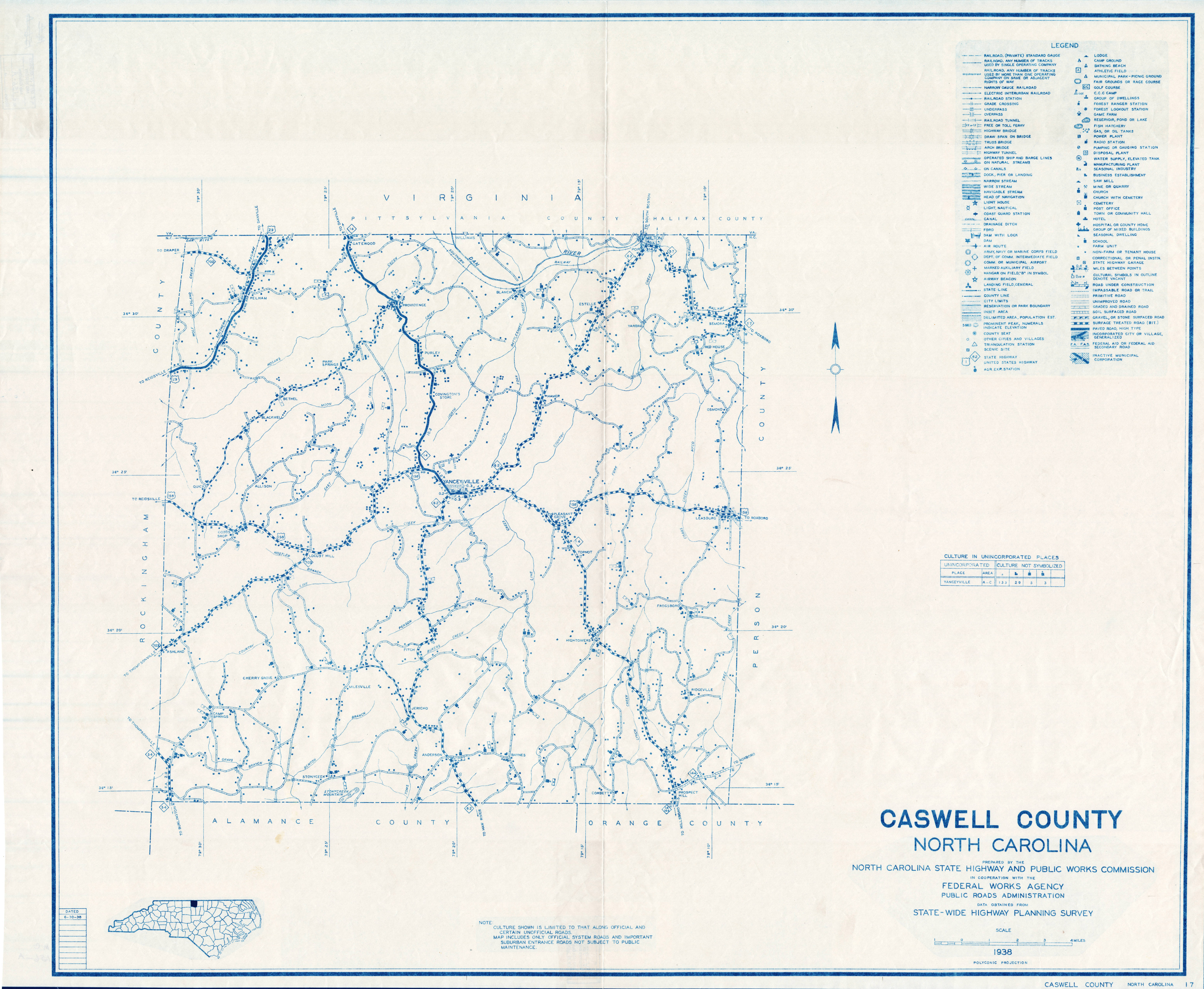
Travel by Caswell County's early inhabitants was difficult. The land was hilly and crossed by creeks that ran between steep ridges. The early roads of course were no more than paths worn by American Indians and animals. The roads that eventually were trails that followed the tops of ridges in order to avoid steep hills and fast-flowing streams. Note that no interstate highway passes through Caswell County, although that may change as US Highway 29 sees further development in the county's northwest corner. Roads were developed as needed for internal transportation as dictated by the need to move goods to market and for political and social discourse. Many of today's roads are merely paved farm roads that a generation ago were dirt (some had been gravelled, but not all). Passage during the wet months was difficult at best and often impossible. The lack of usable roads was one reason Caswell County was split from Orange County and why Person County was separated from Caswell County. Those with business at the county seat found the trip too difficult.
US Highways
US Route #29 - enters in the northwest in Pelham Township, runs northeast through Pelham and exits into Virginia at Danville. US Route #158 - enters in the east near Leasburg, continues to Yanceyville, the southwest through Locust Hill and Casville (formerly Cross Roads), and exits into Rockingham County NC State Roads
NC Highway #49 - enters in the southeast near Prospect Hill and runs northeast into Person County. NC Highway #57 - enters in the northeast near Semora, runs northeast to Milton NC Highway #62 - enters in the south near Anderson and runs north to Yanceyville where it swings to the northeast running through Hamer, Estelle, and Milton, then exits into Virginia across the Dan River. NC Highway #86 - enters in the southeast near Prospect Hill and runs northwest to Yanceyville and then north to the Virginia line near Danville. This was the main road between Yanceyville and Hillsborough (Orange County). After its creation in 1777, Caswell County remained part of the Hillsborough District and, among other things, was required to send jurors for the superior court. For an interesting 1926 newspaper article about the northern portion of this road see: Danville-Yanceyville Concrete Road. NC Highway #87 - enters in the far southwest and runs northwest for a short distance before entering Rockingham County near the intersection with the Cherry Grove Road. NC Highway #119 - enters in the south near Baynes in Anderson Township and runs northeast to Hightowers, then to Semora, and exits into Virginia north of Semora. NC Highway #150 - enters in the southwest near Ashland and runs northeast to US Route #158 at Locust Hill. NC Highway #700 - enters in the far northwest and runs southeast where it intersects with US Route #29. It continues east as the Shady Grove Road. On NC Highway #700 is found the NC Welcome Center. NC Highway #711 - intersects with NC Highway #119 north of Semora and runs east into Person County. NC Highway #736 - also called Gatewood Road, enters from Virginia north of the Gatewood Community near Danville, Virginia, and intersects with NC Highway #86. County Roads
Caswell County has hundreds of county roads and streets. Set forth below are some of the more important ones.
- Allison Road
- Badgett Sisters Parkway
- Baynes Road
- Bertha Wilson Road
- Bethesda Church Road
- Blanch Road
- Boy Scout Camp Road
- Broad Street (Milton)
- Brown's Chapel Road
- Burton Chapel Road
- Camp Springs Road
- Cherry Grove Road
- Corbett Ridge Road
- County Home Road
- Culver Road
- Firetower Road (Yanceyville)
- Foster Road
- Gentlemen's Ridge Road
- Henry Warren Road
- High Rock School Road
- Hightowers Road
- Hines Hatchett Road
- Hodges Dairy Road
- Jack Pointer Road
- John Bigelow Road
- Kerr's Chapel Road
- Longs Mill Road
- Main Street (Yanceyville)
- Marshall Graves Road
- Mary Jane Bigelow Road
- Melvin Wrenn Road
- Milesville Road
- Moorefield Road
- Mountain Hill Road
- New Hope Church Road
- New Walters Mill Road
- Old NC Highway #86
- Old Bigelow Road
- Old Satterfield Road
- Oliver Hill Church Road
- Oscar Gammon Road
- Park Springs Road
- Pemberton Street (Yanceyville)
- Pleasant Grove Road
- Powell Road
- Purley Church Road
- Quick Road
- Rascoe Road
- Rat Castle Road
- Ridgeville Road
- River Bend Road
- Roscoe Dameron Road
- Seamster Road
- Shady Grove Road
- Slade Road
- Snatchburg Road
- Solomon Lea Road
- Stadler Road
- Stage Coach Trail
- Stephentown Road
- Strader Road
- Union Ridge Road
- Vernon Road
- Wall Street (Yanceyville)
- Weadon Road
- West Main Street (Yanceyville)
- Wildlife Road
- Wildwood Lake Road
- Yarborough Mill Road
- Zimmerman Road
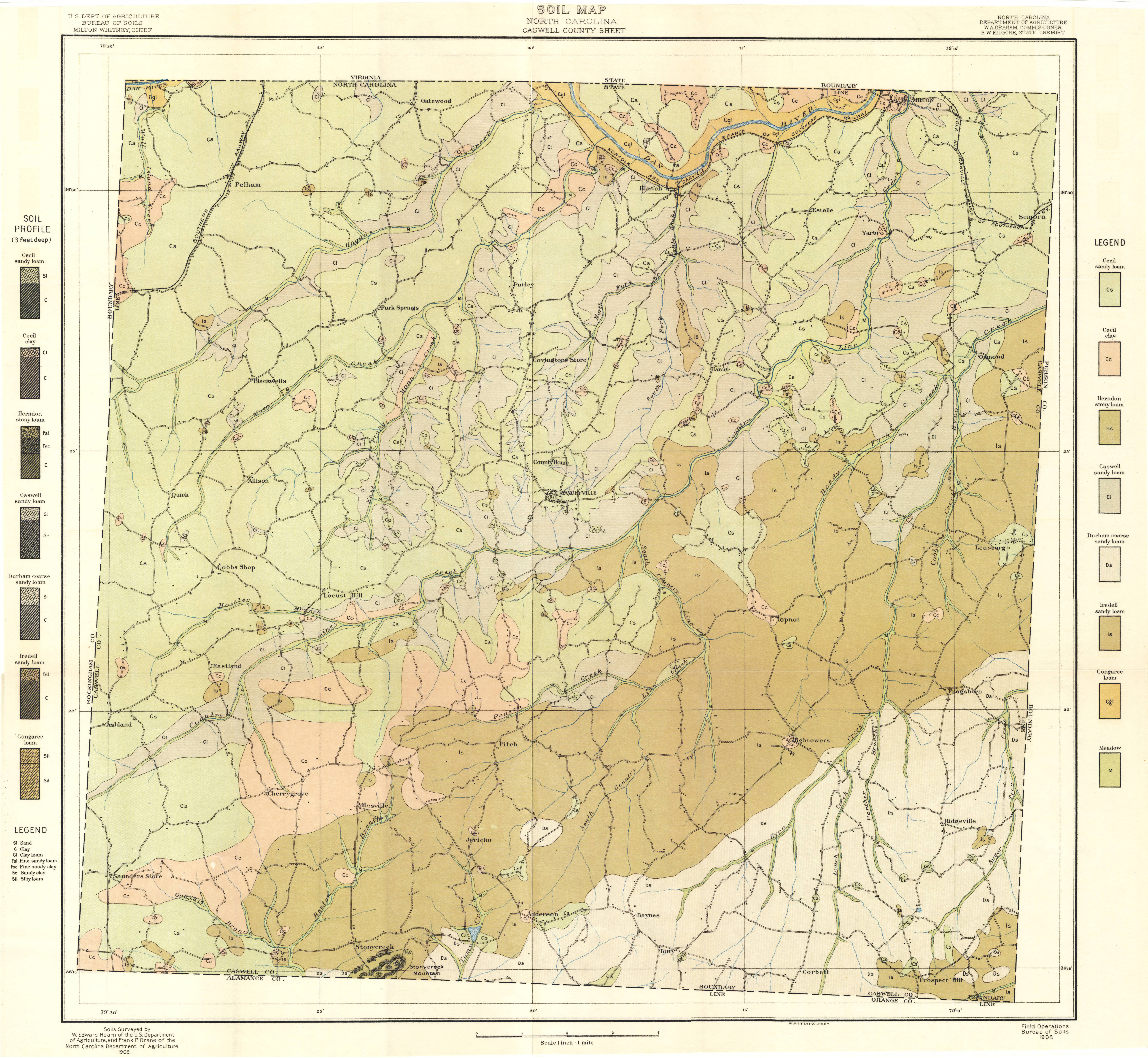
The source of the much of the above information with respect to the soil of Caswell County is When the Past Refused to Die: A History of Caswell County North Carolina 1777-1977, William S. Powell (1977) at 13-15.Critical to understanding the history of Caswell County and its tobacco-based economy is its soil. The land allowed intensive agriculture that supported the boom years before the Civil War. However, without knowledge of soil conservation, the soil became depleted and contributed to the difficult economic times after the Civil War. In the 1930s, Caswell was noted as the state's most eroded county. After the Civil War much land in the county had been abandoned insofar as farming was concerned and depression, the lack of transportation, and adequate labor had resulted in great waste. In 1935, the Dan River Soil Conservation District was established with headquarters in Greensboro and including in addition to Caswell County, the counties of Person, Rockingham, and Stokes. In Caswell County, Leon F. Lyday became county conservationist, established throughout the nation as part of a federal program to provide employment for young men during the Depression, provided labor to halt erosion. Alfalfa was planted to help hold soil in place as well as to restore fertility. Meadowstrips were laid off and maintained and terraces were constructed in many fields to hold back the water from rain and to channel it properly out of the field. Within a nine-year period, nearly seven hundred farms comprising about 90,000 acres of land had instituted soil conservation practices. In many instances farm yield increased as much as fifty percent through improved methods of cultivation. On some farms income increased two hundred percent.
The 1908 Soil Survey of Caswell County resulted in an eight-category classification of the soil there. Basically a sandy loam predominates, but that is broken down into four different types. Nearly forty percent of the soil is described as the Cecil Sandy loam which is a gray, yellowish-gray, or brown medium sandy loam ranging in depth from five to fifteen inches. In places, however, much of the surface soil has been washed off leaving spots that are naturally brown or reddish. Quartz gravel and quartz fragments in large quantity may be seen in these places. Such spots are colled flinty knolls or ridges. The surveyors described the Cecil Sandy loam as a "mellow" soil, easily tilled, and, they said, "if plowed under proper conditions of moisture breaks up into a loose, mellow tilth.
The subsoil to a depth of thirty-six inches or more is a stiff, red clay, tough and hard when dry but sticky when wet. In a few areas, especially around Blackwells and Quick, it was described as "reddish-yellow or mottled" and in those areas angular quartz and veins of quartz were found in it.
The second most common type of soil is that identified as Iredell sandy loam. It consists of a dark-gray or dull-brown medium to fine sandy loam, six to ten inches deep, covering approximately twenty-three percent of the county. This type land is sometimes spoken of as "black-jack oak" or "beeswax" land. On knolls and ridges wehre the surface has not eroded this soil is a loose, medium, sandy loam, while on more level areas it is a find sandy loam or mellow loam. Occasionally a few small iron concentrations may be found in this type soil. Beneath this to a depth of about thirty inches is a yellowish, light-brown, stick, impervious clay. In some of the less well drained areas, a thin iron crust, known locally as hardpan, may be found between the soil and the subsoil.
Appriximately fifteen percent of the county is covered with a soil designated Caswell sandy loam. It is six to ten inches deep, light-gray, yellowish-gray, or ashy medium sandy loam, usually containing a few fine fragments of gneiss or quartz. The subsoil in these areas is a yellow sandy clay with spots of mottled or reddish clay. Caswell sandy loam is described as being a product of excessive erosion as rain water carried away the finer particles in suspension, leaving the coarser ones to form a loose sandy loam soil.
Amont the other types of soil, covering smaller portions of the county, are Durham coarse sandy loam, a light-gray, coarse, sandy loam, sometimes locally called "isinglass land," but very good for bright tobacco; Congaree loam which occurs along the river as a brown silty loam; Herndon stony loam, a fine sandy loam containing from forty to sixty percent rock fragments; and meadow, a varied soil along the streams, often only a few feet above the normal water level of the streams and not generally used.
Soil Survey of Caswell County, North Carolina (1908) 1908 Caswell County Soil Map
The source of the above information with respect to the springs of Caswell County is When the Past Refused to Die: A History of Caswell County North Carolina 1777-1977, William S. Powell (1977) at 15-16.There are countless springs around the county and many of them are well known locally for their association with certain families or events. Two, however, were of enough significance that their waters were analyzed early in the twentieth centurya nd described in a publication of the Geological and Economic Survey of the state. Strader's Spring, located about two and a half miles northwest of Pelham was owned by G. W. Strader. Water from the spring comes up into a stone basin and for many years was a popular place for campers and picnickers. By the early 1900s, however, it was no longer being maintained. The flow of the spring wa reported to be about one-half gallon a minute; the water had no decided odor or taste but was slightly milky in appearance. The analysis of Strader's Spring mineral water revealed that it contained just over 23 parts of lime per million with soda at 10 parts as the next most common component. Magnesia was third at 9.4
The second spring described in the report was Parks Spring, six miles east of Pelham where the water comes up beside a small creek into a section of terra-cotta pipe. In this case the spring was clean and well maintained, the water being popular among those in the surrounding country and as far away as Danville, Virginia. The analysis of Parks Spring water was similar to that of Strader's Spring; in this case there were 33.7 parts lime per million and 14.1 of soda.
Parks Spring Strader's Spring
The most significant streams in Caswell County are:
- Benaja Creek - Rises in the central part of the county south of Yanceyville and flows northeast into South Country Line Creek.
- Benton Branch - Rises in the southwestern part of the county and flows into Stony Creek.
- Burkes Creek - Rises in the south and flows northeast into Pinson Creek.
- Cane Creek - Rises in Virginia and flows south into Caswell County where it enters the Dan River.
- Cobbs Creek - Rises in the east and flows northeast into Person County where it enters Hyco Creek.
- Country Line Creek - Rises in southeastern Rockingham County and flows northeast across Caswell County into Virginia where it enters the Dan River north of Milton. it is mentioned by this name in local records as early as 1752 and was probably named from the eighteenth century custom of calling the North Carolina-Virginia line the "country line," as the two colonies were regarded as different countries. Country Line Creek clearly has been a source of good fishing for many years. In December, 1777, Richard Moore, one of Caswell County's first two members of the new State House of Commons, introduced a bill to prevent the obstruction of fish passing up Country Line Creek but his bill was rejected.
- South Country Line Creek - Rises in the south and flows northwest into Country Line Creek.
- Coy Creek - Rises in Virginia and flows southeast into Caswell County where it enters the Dan River.
- Dan River - Rises in Patrick County, Virginia, and flows southeast into Stokes County, North Carolina. it flows southeast and northeast into Rockingham County and back into Virginia. It then dips back into North Carolina in Caswell County near the Rockingham County line and again farther east after which it flows northeast into Virginia and into Kerr Reservoir on the Roanoke River. It was mentioned by William Byrd in 1728 and the name is probably Indian in origin. Byrd described the Dan as a "charming" river and he and his men paused to enjoy the view. The water was perfectly clear and flowed along at about two miles an hour when the water was lowest. "The bottom," he noted, "was covered with a coarse gravel, spangled very thick with a shining substance that almost dazzled th eye, and the sand upon either shore sparkled with the same splendid particles. At first sight, the sunbeams, giving a yellow cast to these spangles, made us fancy them to be gold dust and consequently that all our fortunes were made. Such hopes as these were the less extravagant because several rivers lying much about the same latitude with this have formerly abounded with fragments of that tempting metal. . . . But we soon found ourselves mistaken, and our gold dust dwindled into small flakes of isinglass. However, though this did not make the river so rich as we could wish, yet it made it exceedingly beautiful."
- Fuller's Creek - Rises in the southwest and flows north into Moon's Creek.
- Glasby Branch - Rises in Virginia and flows southeast into Caswell County where it enters Cane Creek.
- Gray's Branch - Rises in the southwest and flows southeast into Stony Creek.
- Hogan's Creek - Rises in the southwest and flows northeast into the Dan River.
- Hostler Branch - Rises in the west and flows east into Country Line Creek. It appears as Hosley Branch on some early maps of the county, although neither name is represented among those in the 1790 tax list for the county.
- North Hyco Creek - Rises in the south and flows northeast into Person County where it joins South Hyco Creek to form Hyco River.
- South Hyco Creek - Rises in northern Orange County and flows north into Caswell County. It then flows northeast into Person County where it joins North Hyco Creek to form Hyco River.
- Jordans Creek - Rises in the south and flows southwest into Alamance County where it enters Stony Creek.
- Kilgore Creek - Rises in the east and flows north into North Hyco Creek. Perhaps named for Robert Kilgore who had a grant of land in 1752 on North Hyco Creek.
- Kilgore Creek - Rises in the northeast and flows west and northwest into Country Line Creek. It probably was named for William Kilgore who was a chain bearer in the 1754 survey of land for Robert Wilkins on Country Line Creek.
- Lick Fork Creek - Rises in southern Rockingham County and flows northeast into Caswell County where it enters Hogan's Creek.
- Little Mill Creek - Rises in the northeast and flows southeast into Hogan's Creek.
- Lynch Creek - Rises in northern Orange County and flows north into Caswell County where it enters North Hyco Creek.
- Moon's Creek - Rises in the west and flows northeast into Dan River.
- East Prong Moon's Creek - Rises in the west and flows northeast into Moon's Creek.
- Panther Branch - Rises in the southeast and flows north into North Hyco Creek.
- Pinson Creek - Rises in the south and flows northeast into South Country Line Creek. Perhaps named for the Aaron Pinson whom William Byrd found living in the area in 1728 and who took out grants for land in 1754 and 1758, or for Joseph Pinson, a chain bearer in 1755 when land was surveyed along Fishing Creek, now in Person County.
- Pumphouse Branch - Rises in the northwest and flows southwest into Little Wolf Island Creek.
- Pumpkin Creek - Rises in the northwest and flows northeast into Virginia where it enters the Dan River.
- Rattlesnake Creek - Formed in the north by the junction of North Fork and South Fork Rattlesnake Creek and flows north into the Dan River.
- Little Rattlesnake Creek - Rises in the northeast and flows north into the Dan River.
- North Fork Rattlesnake Creek - Rises in the central part of the county and flows northeast to join South Fork in forming Rattlesnake Creek.
- South Fork Rattlesnake Creek - Rises in the central part of the county and flows northwest to join North Fork in forming Rattlesnake Creek.
- Reedy Fork Creek - Rises in the east and flows northeast into North Hyco Creek.
- Stony Creek - Rises in the south and flows south into Alamance County where it enters Haw river. It appears as Marrow Bone River on the Edward Moseley map of 1733.
- Sugartree Creek - Rises in the southeast and flows southeast into the South Fork Hyco Creek. It was named by William Byrd in 1733 for the "sugar trees" [maple] growing along its banks which woodpeckers tapped for the sweet sap.
- Tardy Branch - Rises in the northwest and flows northwest into Little Wolf Island Creek.
- Toms Creek - Rises in the south and flows south into Alamance County where it enters Stony Creek.
- Whalebone Back - Rises in the northwest and flows southeast into Pumpkin Creek.
- Wolf Island Creek - Rises in south central Rockingham County and flows northeast into northwestern Caswell County where it turns north to flow into the Dan River.
- Little Wolf Island Creek - Rises in the northwest and flows north into Wolf Island Creek.