 |
|
TOWN
OF NORTH ADAMS, BERKSHIRE COUNTY, MASSACHUSETTS
|
|
|
INCORPORATED
1878 (TOWN) - INCORPORATED
1895 (CITY)
|
|
City
Hall
- 10 Main St. - North Adams - (413) 662-3000
Open - Monday thru Friday - 8:00 AM - 4:30 PM
City Council Meeting Dates
Second and Fourth Tuesdays - 7:30 PM
Council Chambers - City Hall
|
|
|
|
|
North
Adams
is a flourishing manufacturing town on the Hoosac River, in
the northern part of Berkshire County. The junction of the
Housatonic Railroad, running south through the county, with
the Fitchburg Railroad at North Adams is 143 miles (by the
latter road) northwest of Boston. The other stations on this
road are Greylock and Blackinton. The post-office is North
Adams; and the villages are the places already mentioned and
Beaver, Braytonville, Houghtonville and Kempville. The town
is bounded on the north by Clarksburg, east by Florida, south
by Adams, and west by Williamstown. The assessed area is 9,670
acres. There are 3,866 acres of forest, consisting in part
of maple, beech, birch and cherry.
The scenery of the town is wild and picturesque. At the southwest
is Saddle Mountain, with Greylock farther south. At the southeast
corner is Spruce Hill; 5,288 feet high. This forms the southern
point of Hoosac Mountain, which is pierced from east to west
by the Hoosac Tunnel, on the Fitchburg Railroad. The western
end of the tunnel is a little southeast of the geographical
centre of the town. A full account of this work is given under
the head of "Florida," in which town the eastern
end is situated. The principal streams are the Hoosac and
its northern and southern branches, which unite at the chief
village - North Adams, thence flowing in a general northwest
course to Blackinton village, at the northwest angle of the
town, thence through Williamstown, and across the southwestern
angle of Vermont, to the Hudson in New York. On Hudson Brook,
which enters the North Branch of the Hoosac, just below the
northern line, there is a very curious natural bridge of limestone.
The water, for a space of some 30 feet, has cut a channel
in the white marble about 15 feet wide, through walls from
30 to 60 feet high, which at one place form an arch of solid
rock over the stream. In Notch Brook, from which North Adams
village is supplied with an abundance of pure water, there
is a very beautiful cascade, where, in a deeply wooded glen,
the water plunges down a precipice about 30 feet. The basal
rock of .the town is Lauzon schist, Potsdam and Levis limestone.
Both limestone and marble are quarried. The valleys are quite
free from wood, and have a rich loamy soil, while the highlands
are sandy or gravelly. There are many fruit trees.
The
aggregate product of the 96 farms in 1885 amounted to $121,467.
There were six boot and shoe factories, employing some 650
persons, and making goods to the value of $1,178,492; four
cotton mills with dyeworks, employing 870 persons; one woollen
mill employing 233; and printworks employing 652 persons.
The aggregate value of the textiles made was $4,531,885. Other
manufactures were zylonite goods (employing 59 persons), leather,
carriages, wrought stone, metallic goods, boxes, bricks, furniture,
brooms, clothing, soap, tobacco and liquors. The aggregate
value of goods made was $6,469,479. The capital stock of the
two national banks was $700,000; and the two savings banks
at the close of last year held deposits to the amount of $1,859,772.
The valuation in 1888 was $5,610,833, with a tax-rate of $17
on $1,000. The taxed dwelling-houses were 1,763 in number.
The population in 1880 was 10,191; in 1885, 12,540. At the
latter date there were 2,543 legal voters, The town has graded
schools. There is a high school, bearing the name of Drury
Academy, conducted on a finely developed system. The value
of the school buildings and appurtenances in 1885 was $126,300.
The public library contained 5,777 volumes. The local papers
are the "Berkshire Leader," the "Hoosac Valley
News," the "Adams Transcript" and the "
Sunday Express," all weeklies. The churches are one each
of the Baptists, Congregationalists, Methodists, Episcopalians,
Universalists, and two of the Roman Catholics.
This place long bore the name of East Hoosac. Many of the
first comers were from Connecticut, but most of these sold
their holdings to a more numerous influx from Rhode Island,
who were largely Friends. The nucleus of the settlement was
a saw mill and a grist mill at North Adams. The Rev. Samuel
Todd, settled in 1780, was the first minister. The Friends
organized a society in 1781; meeting at first in a log-house,
but erecting a better building a few years later. Fort Massachusetts,
one of a cordon of defences for protection against the French
and Indians, was constructed by Col. Williams about
1744. It stood on the north side of Saddle Mountain. On August
26, 1746, it was gallantly defended by Col. Hanks against
an attack of 900 French and Indians; but, after destroying
45 of the assailants, he was obliged by lack of ammunition
to surrender. The fort was again bravely defended by Col.
Williams, on August 2, 1748, against 300 French and Indians.
The town was set off from Adams and incorporated under its
present name on April 16, 1878. Chinese laborers to the number
of 40 or 50 were employed with profit in one of the shoe factories
here about 1810; but nearly all have departed from the town.
One or two have become citizens.
pp.
506-507 in Nason and Varney's Massachusetts Gazetteer, 1890
|
| |
| North
Adams, founded in 1878, its parent town was Adams |
| BIRTHS |
Resource
needed! |
|
| MARRIAGES
(1763-1917) |
Under
development |
|
|
|
|
Transcribed
by Ray Brown |
|
DEATHS
(1781-1917)
Courtesy of Claire Smith and Laurel O'Donnell
|
|
|
CEMETERIES
|
|
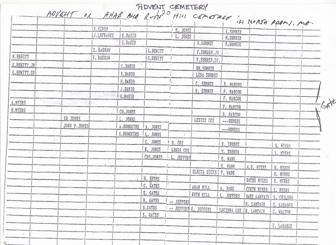
aka
Ahab & Ruth Hill Cemetery |
|
|
|
|
Ahab
& Ruth Hill Cemetery |
See
Advent Cemetery |
|
|
|
|
First
Congregational Burial Grounds |
aka
Old East Hoosuck Cemetery |
|
Hillside
Cemetery |
A
- D, E
- L, M
- S, T
- Z |
|
Old
East Hoosuck Cemetery |
|
|
St.
Josephs Cemetery |
|
|
South
View Cemetery |
A
- C, D
- J, K
- P, Q
- Z |
|
Wilbur
Cemetery |
|
|
|
by
W. F. Spear. North Adams, Mass., Hoosac Valley News Printing
House, 1885. Full text version page by page. This
item is not indexed, it appears exactly as the print version,
however an index is available from the Berkshire Family
History Assocation for a small fee should you be interested.
Transcribed by Bettye Seaton Liberty
|
|
|
List
of students, faculty & advertisers.
|
Transcribed
by Vikki Gray |
|
|
1906-1911
Graduates
|
Transcribed
by Ray Brown
|
|
DRURY
HIGH SCHOOL YEARBOOKS
|
Archive.org
has a fabulous scanned set of Drury High School Yearbooks,
and includes photos. Follow this link.
|
|
MAPS
|
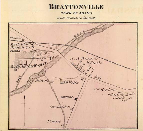
From
"County Atlas of Berkshire, Massachusetts. From actual survey
by and under the Direction of F. W. Beers, Published by
R. T. White & Co., 36 Vesey Street, New York, 1876."
Some maps have names of residents. The map of Beaver
Mill in the town of North Adams is available
for viewing.
|
 |
Beaver
Mill - JPG
Braytonville
- JPG
|
Beaver
Mill - PDF
Braytonville
- PDF
|
| MILITARY |
Resource
needed!
|
|
| PENSIONERS
OF 1790 |
|
|
| PHOTOS |
Send
your North Adams Photos in for posting! |
| EARLY
POSTMASTERS OF EARLY NORTH ADAMS |
|
|
|
|
|
 |
| Return
to [Berkshire County Home Page] |
| ©
Copyrighted from 1995 to present for the benefit of the Massachusetts
GenWeb Project. |
|
