 Wexford is a maritime county set in the south-east
corner of Ireland. It extends from 52� 2' to 52� 44' north latitude and
from 6� 17' to 7� 4' west longitude. The county encompasses a land area
of 909 sq. miles (1454 sq. Km) which makes it the 13th largest county in
Ireland. It is bounded by the Blackstairs and Wicklow Mountains along the
county's western and northern borders, and by the sea on the east - St.
George's Channel. The coastline is low, irregular, and hazardous to navigation,
with the result that there have been many wrecks along the coast from Viking
long boats to German U-boats.
Along its 75 miles (120 Km) of sandy beaches lie the main bays - Wexford Bay; Rosslare Bay; Ballyteige Bay; Bannow Bay; Sandeel Bay; Lumsdin's Bay; and Tacumshin Bay. The main rivers flowing through the county are the Slaney; Barrow; Corock; and the Bann. Mount Leinster at 2610 feet (796m) is the highest point in the county. Wexford boasts the country's richest agricultural land with approximately one-third of the land under cultivation. Principal crops being grains and root vegetables. Pigs, poultry and dairy cattle are also raised on the land, while slate and marble are mined, and the coastal waters support numerous fisheries. With a population of approximately 105,000, the county of Wexford has four main towns, Wexford, Enniscorthy, Gorey and New Ross. Wexford also has some of the most spectacular scenery in Ireland, and enjoys more hours of sunshine than any other part of Ireland. Administrative DivisionsOf the administrative divsions of Ireland, five are civil divisions of antiquity: Province, County, Barony, Civil Parish and Townland; four are associated with mid-nineteenth century introduced legisation: Poor Law Union, Dispensary District, Superintendent Registrar's District and Registrar's District; and two are ecclesiastical divisions: Diocese and Parish.The most familiar is the county. The structure of the county framework as we know it today was created by statue in 1606 of Wicklow. The county has been and still is the principal unit of local government, and most collections of documents are organised by county.
The Province |  The Province dates back to the time
of the Celtic Gaels. From their more than 150 petty dominions, five emerged
as the predominant Gaelic Kingdoms which approximately equated to the present
four provinces of Ireland. Ulster in the north, Leinster to the east, Connaught
to the west and Munster in the south. The fifth was the smaller kingdom
of Meath, which eventually was assumed into Leinster. The Province dates back to the time
of the Celtic Gaels. From their more than 150 petty dominions, five emerged
as the predominant Gaelic Kingdoms which approximately equated to the present
four provinces of Ireland. Ulster in the north, Leinster to the east, Connaught
to the west and Munster in the south. The fifth was the smaller kingdom
of Meath, which eventually was assumed into Leinster.
County Wexford lies at the south east corner of the Province of Leinster.
The Baronies of County Wexford |  In Ireland, Baronies are a portion
of a county, or a group of Civil Parishes and may span parts of more than
one county. Their origin is thought to have dated from Norman or pre-Norman
times and be based on the Gaelic family teritory. This division was used
from the sixteenth to the nineteenth century in surveys, land transactions
and censuses. In Ireland, Baronies are a portion
of a county, or a group of Civil Parishes and may span parts of more than
one county. Their origin is thought to have dated from Norman or pre-Norman
times and be based on the Gaelic family teritory. This division was used
from the sixteenth to the nineteenth century in surveys, land transactions
and censuses.
County Wexford contains the Baronies of Gorey, Scarawalsh, Ballaghkeen North, Ballaghkeen South, Bantry, Shelmalliere West, Shelmalliere East, Shelburne, Bargy and Forth. Poor Law Unions of County Wexford |  The division of Poor Law Union was introduced to
Ireland under the Poor Law Relief Act of 1838. They were named after a local
large town in which a workhouse was built for the relief of the detitute
poor within the Union. This division does not always conform to county boundaries.
Rates, and land taxes were collected within these areas for the maintenance
of the local poor. The same districts later became used as General Registrar's
Districts. The division of Poor Law Union was introduced to
Ireland under the Poor Law Relief Act of 1838. They were named after a local
large town in which a workhouse was built for the relief of the detitute
poor within the Union. This division does not always conform to county boundaries.
Rates, and land taxes were collected within these areas for the maintenance
of the local poor. The same districts later became used as General Registrar's
Districts.
County Wexford is divided amongst the Poor Law Unions of Gorey, Enniscorthy, New Ross, Wexford and Shillelagh.
Diocese of County Wexford |  Both the Catholic church and the Church
of Ireland arrange their parishes into Dioceses, each presided over by a
bishop. Both churches divise the Diocese to include a certain number of
church parishes resulting in boundaries that do not conform with county
boundaries. Similarly the boundaries of the diocese of both churches do
not conform with one an other. The Church of Ireland dioceses are important
for record purposes such as administration of wills. Both the Catholic church and the Church
of Ireland arrange their parishes into Dioceses, each presided over by a
bishop. Both churches divise the Diocese to include a certain number of
church parishes resulting in boundaries that do not conform with county
boundaries. Similarly the boundaries of the diocese of both churches do
not conform with one an other. The Church of Ireland dioceses are important
for record purposes such as administration of wills.
The majority of the county falls within the Dioceses of Ferns. The exceptions being the Civil Parishes of Inch and Kilgorman which fall in the Dioceses of Dublin, and the Civil Parish of St. Mullin's which is in the Dioceses of Leighlin.
| Civil Parishes
of County Wexford | As the name implies these were originally ecclesiastical divisions and they originated around the thirteenth century. They are important units for record purposes. The Civil Parishes of County Wexford are:
Townlands of
County Wexford | The Townland is the smallest unit of land area in Ireland. The size of a townland varies greatly, from less than ten acres to several thousand acres. Although the name implies it, a Townland does not necessarily contain a town. For rural dwellers the Townland is usually the most specific "address" available. This link will bring up an alphabetical list of the Towlands in County Wexford.
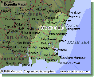
Maps If you are looking for descent maps
to locate where in Wexford your family came from or for touring, then it
is suggested you look at the Ordanance Survey of Ireland Discovery Series
which are at a scale of 1:50 000. To cover the whole of County wexford you
will require maps #'s 62, 68, 69, 76 and 77 from the series. They are topographical
maps, and include Townland
names, though the boundary of individual Townlands is not depicted. There
is no index to place names printed on the map so you will have to study
them well to locate your Townlands of interest if you are not sure where
they are relative to larger towns/villages marked on the map.
If you are looking for descent maps
to locate where in Wexford your family came from or for touring, then it
is suggested you look at the Ordanance Survey of Ireland Discovery Series
which are at a scale of 1:50 000. To cover the whole of County wexford you
will require maps #'s 62, 68, 69, 76 and 77 from the series. They are topographical
maps, and include Townland
names, though the boundary of individual Townlands is not depicted. There
is no index to place names printed on the map so you will have to study
them well to locate your Townlands of interest if you are not sure where
they are relative to larger towns/villages marked on the map.
Links |