Greetings researchers, I've listed 139 cemeteries below on my list, displayed in a township order. Burial lists for most cemeteries are being entered on Findagrave and they are linked below by the current name of each cemetery.
Our County was established in 1826, but we know it was inhabited much earlier. The earliest graves that are marked in our County are in 1811 at the Tippecanoe Battlefield in Battleground, but most tombstone found after that are dated 1820's or 1830's, probably when more stone carvers moved in the area. On my journey around this County, I've taken overall photograph of each cemetery and they are linked below for you to view. We also know, several cemeteries have been completely destroyed.
So many burial records have been thrown away in Tippecanoe County, please share what you know. It will help others in their search for family history and help preserve Tippecanoe County history. If by chance should you have any old burial readings, maps or records that can help share the history of an old cemetery, I want to hear from you. I will be happy to come and digitize the records. Do you have an old church history that was connected to a old cemeteries? If a ledger exist it could help complete a cemeteries history.
L. A. Clugh
Tippecanoe County Cemetery Restoration page
Tippecanoe County Indiana Cemeteries is on Facebook.
Special thanks to David R. Cheesman who help me start on Findagrave. Many of our listings in the southern part of the county have obituaries posted to them thanks to Thelma Brooks-Morgan, she added over 10,ooo burials. Thanks to Amy H. for adding entries for several cemeteries with records and photographs, Kay Harris and to Quentin for adding Old Cairo back on. Plus other members of the TIPCOA / Tippecanoe Co. Area Genealogy Society who continue to help. And to all of you who helped by adding photographs. Together we make it better for everyone. As of October 2016, 139 cemeteries are up online now, all that's left is tweaking & looking for anyone we may have missed. Many people are buried in unmarked graves. Today, Death Records online now exist on Ancestry and FamilySearch, so volunteers are continuing to add new entries. TIPCOA volunteers are finishing the pauper burials from our County records. (see the 4 County Farms or Poor Farms cemeteries) More will come soon on our project called Finding the Forgotten
A link to the Area Plan Commission book is now available. It is in Adobe
Reader format and you must have
this on your computer to use this file. This book has a page with directions for each cemetery known in this
county.
![]() Tippecanoe
County Cemetery Book (pdf)
Tippecanoe
County Cemetery Book (pdf)
![]() Tippecanoe County
Cemetery Map in the same format.
Tippecanoe County
Cemetery Map in the same format.
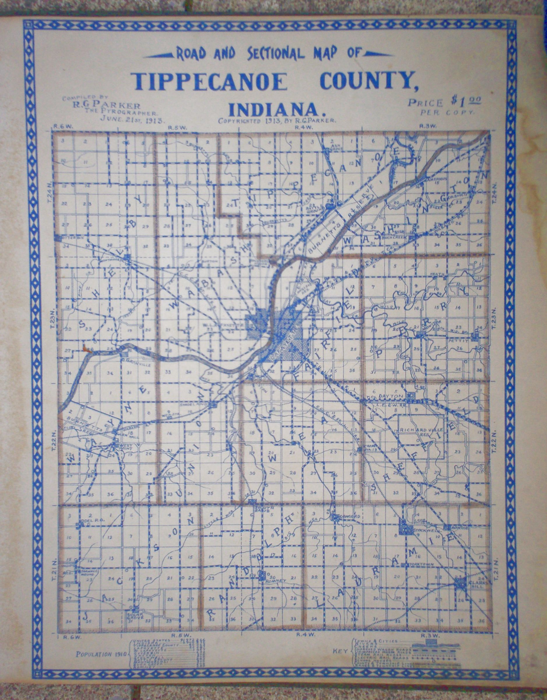
A link for
an older map showing the 13 township
|
|
|||
| DAVIS-HIGMAN
|
sec. 9 | est.1820 | Located on North 9th Street Rd. Past old Duncan plant. Iron fence. |
| FATHER
HAMILTON |
sec 21 | single grave | Burial Tomb in St. Mary's Church basement. Est. 1875 |
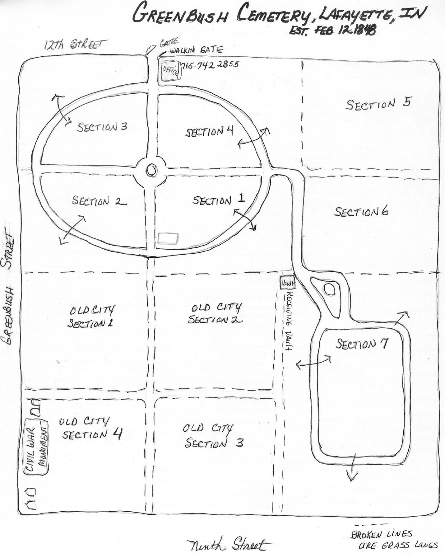
| GREENBUSH Civil War Monument See the Section Map Greenbush Veteran list, Its still growing |
sec 21 | est.1843 | 1408 N. 12th Lafayette, IN. AKA: Lafayette Burial Grounds 1 (182?) & 2. Tombstones and graves were moved to Greenbush sometime in 1863-64. Lafayette City Graveyard began in 1843 in the lower 4 sections. |
| ISLEY
|
sec 13 | est.1820 | Located off Eisenhower Road past subdivision. |
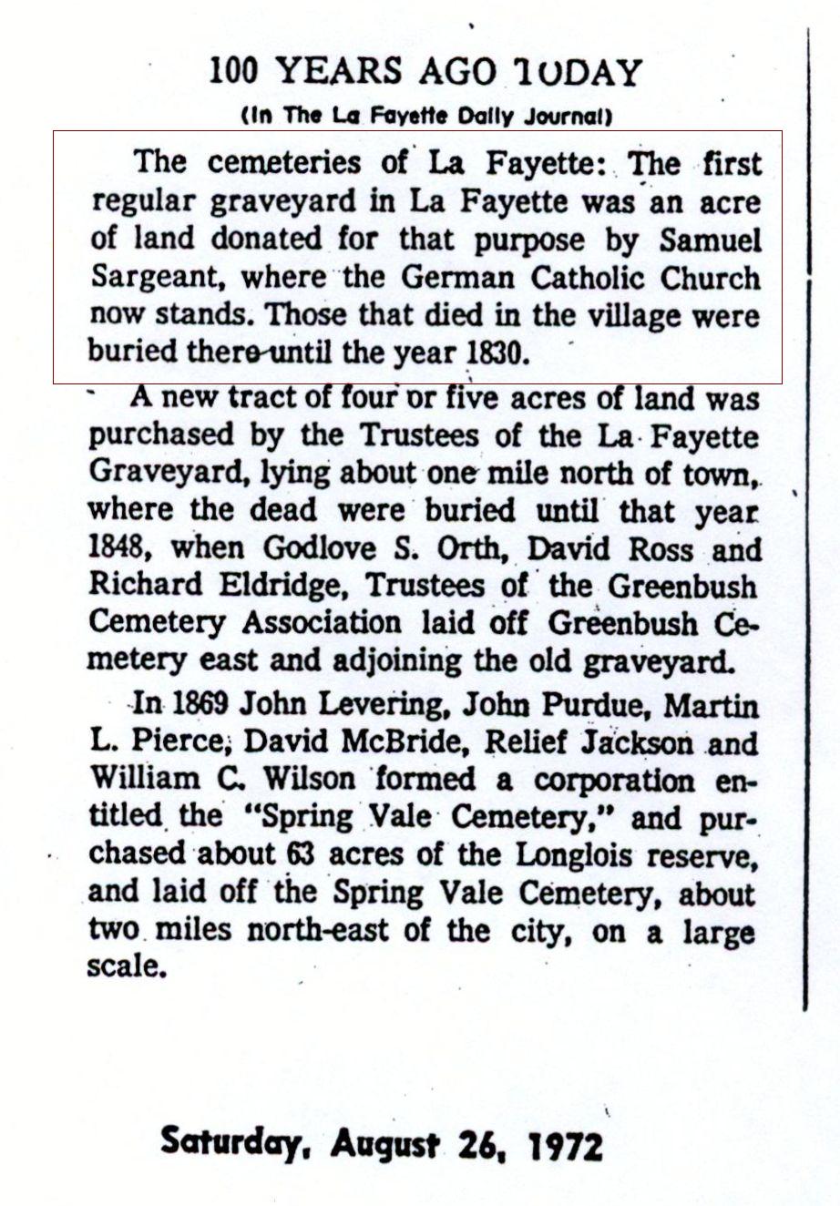
| LAFAYETTE 1ST BURIAL GROUND. 1st Cemetery & Pauper Burials | sec 21 | 1825 | 1st know cemetery was on North and 9th St. Moved to the lower sections of the Lafayette City Cemetery sometime in the 1860s. Article 1. |
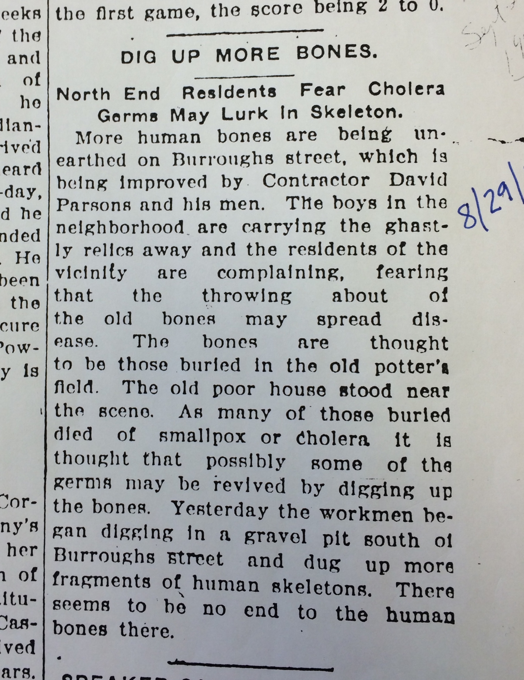
| POOR FARM # 2. (burial's list being worked on) | sec 21 | 1850's | Destroyed Located in Linnwood in the 1850's. At the end of Burroughs Street Article 1 1865 Article 2 1908 |
| REST
HAVEN |
sec 22 | est. 1931 | 1200 Sagamore Pkwy N., Lafayette IN, South of Greenbush St. |
| SPRING VALE
|
sec | est. 1868 | 2580
State Rd 25 N. Lafayette IN, North of 52 on N. side. Website |
| ST.
BONIFACE |
sec | est. 1897 | 2581 State Rd 25 N., Lafayette IN, North of 52 on S. side. Article on beginning |
| ST.
JOSEPH |
sec 16 | est. 1847 | Located on Greenbush St. between 16th & 17th St. in Lafayette. |
| ST.
MARY'S Monument for St Joseph Orphan Asylum for Boys |
sec 31 | est. 1840 | 2122 Old Romney Rd., North of Elston Rd. |
| JEWISH
CEMETERIES -3 Also called Ahavis Achim from 1849-1919. And Sons of Abraham, 3 on same site. Online map. |
sec 32 | est. 1840 | On Montifore Street, South of Owen St. in Lafayette. |
|
|
|||
| PINHOOK |
sec 6 | est. 1828 | CR 800 S & 700 W, back in private woods. Partial destroyed. |
| SHELBY
FARM |
sec 3 | est. 1843 | CR 400 W, on private property. Very nice. All photos online. |
| SUGAR
GROVE a.k.a.
Shawnee Mound Also see the Genweb partial list of abt. 180 burials w/ photos |
sec 32 | est. 1832 | Located
down a long drive and up on a hill off CR
1325 S. |
| WHEELER'S
GROVE or Shawnee Mound. also see the Genweb page This is only a partial list of burials w /photos |
sec 27 | est. 1828 | Located on St. Rd. 25 S. just South of CR 1250 S. |
|
|
|||
| CHILD BURIAL | sec 3 | est. ? | .S. Hwy. 52 south of CR 800 S. * no tombstones* |
| CLARK'S
HILL a.k.a. Clark |
sec 23 | est. ? | Located on CR-975 E., South of Hwy 28 |
| CONCORD |
sec 11 | est. 1842 | South of Concord on CR-300 E. |
| CONROE
CHURCH
a.k.a.Pop's Center |
sec 2 | est. ? | Destroyed. Only hints of this one. Need more information. |
| COSBY
& the Genweb
page |
sec 23 | est. 1835 | Located on CR 1200 S. between 300 E. and 400 E. |
| FAIRVIEW
a.k.a. Stockwell |
sec 5 | est. 1830 | In
the town of Stockwell next to railroad and
700 E. Old stones were moved from the Original Cole Cemetery up town in section 9. |
| GAPEN-BARCUS a.k.a. Barkhurst or Skinner |
sec 7 | est. 1837 | South off CR 900 S. and west of 575 E. back in the farm field. Overgrown. on private property. Partial destroyed |
| HORNEY
a.k.a. Beeville |
sec 32 | est. 1839 | South of CR-1300 S. between 600 E. and 700 E. Up a long dirt lane. |
| JOHNSON |
sec 4 | est. 1830 | Located on CR-800 S. East of Stockwell Road. |
| MONROE
|
sec 10 | est. 1847 | At Monroe on CR 900 S. and U.S. 52 |
| KNIGHT
|
sec | single | Knight family stone was moved to the present location. |
| OLD
UNION a.k.a. Union; Old Campbellite Cemetery. |
sec 35 | est. 1838 | Off 1000 E. just north of the South County Line Road. |
| ROUTH
- PIONEER |
sec 27 | est. 1829 | Restoration 2002 CR 1300 S. on private property |
| SKINNER
|
sec 1 | est. 188? | Only
one grave. Child of John & Nancy Skinner. No name or dates on the
stone. |
| ST.
JOE |
sec 3 | est. 18?? | Restored 2001, 2 stones, in woods off CR 800 S. mostly destroyed. Around 33 people were buried here. List is lost. |
| STINGLEY
|
sec 18 | est. 1843 | South side of 1000 S. just East of CR 500 E. |
| SUMMERS
Family see the Genweb page |
sec | est. 1834 | Located on a farm at road 950 S. on farm land a little west of road 275 E. No longer used; fenced behind the barns. |
| YORKTOWN
|
sec 17 | est. 1848 | Located on 700 E. just south of Stockwell. Founded by Daniel and Rebecca Corkins in 1848. |
|
|
|||
| BOGANS a.k.a. McClintock |
sec 22 | est. 1832 | Completely destroyed. some stone fragments left, east of Hunters Ridge Est. Fragments of stone left. |
| BETHEL CHURCH a.k.a. PETTIT | sec 24 | est. ? | Completely destroyed. Was by the old Church. |
| CEDAR BLUFF | sec | est. 1830 | Completely destroyed. Was on CR- 675 East. |
| CLEAVER
|
sec 10 | est. 1833 | Inaccessible, located on private property. All photos are online. |
| FOSTER
Wade
Farm |
sec 22 | est. ? | CR 850 E. On bluff on private property. Destroyed. 3 stone left |
| UNION-HERSHEY
a.k.a. Union 2nd Burials listed on Find-A-Grave |
sec 9 | est. 1822 | Located on CR 725 E. This Church burnt. Still has the Iron fence. All photos are online. |
| LESLEY
|
sec 10 | est. 1841 | Inaccessible, located on private property. All photos are online. |
| MAHAN
FAMILY
a.k.a. Whistler or Welch Farm |
sec 10 | est. 1839 | On West side of CR 900 E. South of CR 300 N. located on private property. |
| MIKESELL
|
sec 15 | est. 1837 | Off CR 900 E. located on private property. All photos are online. |
| OLD
OXFORD |
sec 36 | est. 1830 | Located at the old church on the Tippecanoe County Line Road East and south of CR 100 S. |
| SWANK
|
sec 25 | On CR 1050 E. at the bend. All photos are online. | |
| ULERY Tippecanoe INPCRP project |
sec 11 | est. 1837 | Located off CR250 N. located on private property. All photos are online. |
| ZION
Page by James Spidle. ZION Thank you James! |
sec 22 | est. 1826 | Located on CR-850 E. This Church burnt. |
|
|
|||
150th Anniversary, Romney, Ind. History booklet published in 1982 by Howard Newton |
Page 8 describes the churches and cemeteries. | ||
| DIETERLY
FARM |
sec 17 | est. 1835 | Previously owned by Charles Dieterly. Its on private property off U.S. 231 road just north of CR 1050 S. Recently destroyed. |
| ELMWOOD
|
sec 18 | est. 1921 | Located on SR 28 between CR 125 W. and U.S. 231. |
| HOUSE
a.k.a. Newton Woods |
sec 19 | est. 1838 | Located in Newton Woods Subdivision Almost destroyed, all stones are down. All photos are online. |
| McCAY
a.k.a. Pioneer or Ivey |
sec 19 | est. 1847 | Several graves; located near Romney cemetery off CR 1150 on private property. Destroyed, some stone fragments left. |
| MINTONYE.
a.k.a. McCutcheon |
sec 1 | est. 1833 | On CR 800 S. and CR 150 W.- Restored 2010 |
| OLD
ROMNEY
|
sec 19 | est. 1830 | Located in Romney on CR 1150. Methodist Cemetery. |
| WITGUS-SHOEMAKER
|
sec 17 | est. 1847 | Destroyed, on private property in back field. Off CR 100 E. A couple tombstone still exist. All photos are online. |
| SHELLY | ? | ? | Location is lost, in the town of Romney. |
|
|
|||
| BAKER |
sec 10 | est. 1838 | Named for Wm. Baker, early pioneer settler. Just south of St. Rd. 38 on CR 900 E. Restored 2007. All photos are online. |
| BATES | sec 35 | est. 1844 | Destroyed,
no visible remains on east side of
CR 1000 E. beside or behind Newcomer church. |
| BOGGS | sec 27 | est. 1837 | Was a Campbellite Church cemetery. Destroyed. |
| BOOHER & on Interment.net | sec 22 | est. 1829 | Alexander Booher family cemetery. Located just north of CR 600 S. between CR 1000 E. and 1075 E. Not found today?? |
| BRADLEY | ???? | est. 1830 | On bluff SE of site of Boggs Cemetery, Never found. |
| BUSH
|
sec 9 | est. 1848 | Inside the Dayton corporate limits. All photos are online. |
| DAYTON |
sec 4 | est. 1840 | Just east of Dayton city limits on St RD 38 Restored 2009-10. All photos are online. |
| HOLLIDAY
|
sec 36 | est. 1820 | Restored 2004, & mostly destroyed. CR 1000 E & New Castle Rd. All photos are online. Over an acre gone. |
| LEAMING
FARM
|
sec 36 | est. 1844 | Located on East County Line Road and New castle Road. Restored 2005. All photos are online. |
| McDOLE a.k.a. Lauramie Missionary Baptist |
sec 36 | est. 1847 | On New Castle Road, past CR 1000 E. Restored 2008. All photos are online. |
| NEW
CASTLE |
sec 34 | est. 1847 | Partially destroyed, On private property on bluff. All photos are online. |
| NEWCOMER a.k.a. Funk Cemetery |
sec 26 | est. 1849 | Located south of CR 600 S. on CR 1000 E. Restored 2008 & 09. All photos are online. |
| SALEM
|
sec 33 | est. 1845 | Began as Salem Methodist Chapel in 1840. Located on CR-775 E. and Stockwell Road. |
| WYANDOTTE |
sec 16 | est. 1830 | Located on the site of Wyandotte Village - east side of Dayton Road and north of Wyandotte Rd. |
|
|
|||
| ADE | sec 27 | est. -? | At the sight of St. Paul's church CR 75 S. & CR 875 W., no visible remains, Destroyed. Some stones moved to Asbury. |
| ASBURY
a.k.a. Downs Over 100 tombstone photos have been added also on the Genweb |
sec 23 | est. 1843 | On Kerber Road between CR-125 N. and Division Road. |
| DAWES | Jackson Hwy and CR 600 W. No visible remains. | ||
| DAWSON
a.k.a. Bryan Farm |
sec 15 | est. 1828 | Very bad shape partially destroyed. |
| MONTMORENCI
|
sec 6 | est. 1840 | Located in the town of Montmorenci on CR 650 W. and CR 350 N. Behind the old Church. |
| O'LEARY
a.k.a. Cook Family |
Some visible remains. CR 675W. Lost. I didnt find it. | ||
| SHAMBAUGH
a.k.a. Charles Parker |
sec 1 | est. 1832 | Located at CR 300 N. and CR 750 W. Not in great shape. |
| SPENCER-BEST |
sec 7 | est. 1833 | Destroyed, Overgrown, all stones are down, but they are there. |
|
|
|||
| ASH
GROVE a.k.a. OLD HARVEY on the Genweb |
sec. 3 | est. 1835 | CR 900 N. East of 43. Restored 2002-2003 by family. All photos are online. |
| BATTLE
FIELD MEMORIAL
& see the Genweb |
sec 23 | est. 1811 | Memorial to the Battle of Tippecanoe. All photos are online. |
| BATTLE
GROUND Complete transcription online at the Genweb site. Thank You Mary Wilson |
sec 13 | est. 1829 | North of the town of Battle Ground on Pretty Prairie Road. |
| BURNETT'S
CREEK
a.k.a. Bryant |
sec 28 | est. 1834 | Partially destroyed. Located on 600 N. between 75 E. and St. Rd. 43. All photos are online. Partial destroyed |
| CAIRO a.k.a Old Radical Cemetery. | sec. 3 | est. 1830s | Completely destroyed. Burial list added. Some stones moved to Liberty Chapel. |
| COUNTY
FARM # 3 a.k.a. Potter's Field. Recently renamed Stevens-Barnhardt & Genweb page |
sec 30 | est. 1847 | Destroyed , 2 Stone visible left. East side of CR- 50. Stone are in a corner of a field. Some obits are linked. All tombstone photos are online. Over 200 are buried here. Article 1-1880 |
| DEARDURFF 2 stone photographed | sec | est. 1835 | Destroyed, Stones moved to Hurst Cemetery. |
| HARRISONVILLE
|
sec 23 | est. 1816 | Located within Battle Ground town limits, next to the chapel on the grounds of the Tippecanoe Battlefield Park. |
| HOG
POINT a.k.a. Corwin Cemetery |
sec 8 & 17 | est. 1835 | Located on private property off the end of Goldsberry road. All stones are down. |
| HURST
a.k.a. Swisher or Sand Ridge |
reserve | est. 1830 | No longer used. In wooded area, east of Swisher Road. On private property, way back in the fields. |
| JUSTICE | sec. 5 | DAR had readings of this cemetery. It was located in the wooded are known as Schearer Wood’s Destroyed. No visible remains. | |
| COUNTY FARM #4 LAUREL
HILL Another County Farm Cemetery often called Potters field or County Poor Farm #4. |
sec 30 | est. 1930s | Located on the west side of CR 50 W. just south of William Henry Harrison High School. These burials did not have tombstones. I'm working on a buril list from death certs.. |
| LIBERTY
CHAPEL CHAPEL on the Genweb. |
sec. 4 | est. 1832 | E. U. B. Cemetery located on the north side of CR 900 N. |
| PIERCE
a.k.a. Price |
sec 30 | est. 1830s | Located behind William Henry Harrison High School on CR50 W. Next to tennis courts behind the school. |
| PRETTY
PRAIRIE |
sec 8 | est. 1838 | Located on Tyler Road, north of Battle Ground. |
|
|
|||
| BAER
or FRAZER
a.k.a Lilly |
sec 35 | est. 1829 | West of the Eli Lilly (now Evonic) Plant on ridge over Wea Creek. On Lilly property permission is needed to access.. |
| CANAL a.k.a. Sears, Comet Fry, Irish or Stuart Farm. |
sec 33 | est. 1840s | Located off CR 500 W and 75 S. Mass burial for Irish workers of Wabash & Erie Canal period who died from Malaria. Very bad shape. Now a cow pasture. Much destroyed and unknown. |
| DURKEE
a.k.a. Dimmitt |
sec 15 | est. 1846 | No longer used; CR 450 S. and 375 W. back in a field. Very bad shape. Restored |
| FARMER'S
INSTITUTE
|
sec 27 | est. 1831 | Just east of Farmer's Institute Church on CR 660 S. |
| FIRST
MINTONYE
a.k.a. Barnett |
sec 2 | est. 1846 | On CR 250 W. just south of Eli Lilly Road. On private property. Not accessible. |
| HICKORY
GROVE
a.k.a. Taylor, Taylor's Station or Benett Farm |
sec 13 & 24 | est. 1839 | On the corner of 500 S. and 150 W. Restored 2006. All photos are online. |
|
|
|||
| POOR FARM # 1 ( burial's list being worked on) | est. 1830s | Destroyed. The first Poor Farm was located in this township. Sold by the County. Long gone and developed now. | |
| BURTON
a.k.a Old Bilderback or Klondike Cemetery. A few tombstone pictures have been added |
sec 2 | est. 1831 | In good condition; located on the corner of U.S. 52 and 300 W. across from Klondike Middle School. |
| DRISCOLL | sec | Destroyed. No visible remains. | |
| GRAND
VIEW |
sec 18 | 19 | 1510 N. Salisbury West Lafayette, IN |
| HEBRON
a.k.a. Grand Prairie Baptist, not Mt. Zion. |
sec 35 | est. 1824 | Located on 500 N. just east of Morehouse Road. |
| McCORMICK
|
sec | est. 1838 | McCormick Road & Stadium Ave. Up the hill to the west. Gated. |
|
JOHN
PURDUE
MEMORIAL |
sec | single grave | Gravesite of John Purdue on the Purdue University Campus in Memorial Mall. |
| DAVID
E. ROSS
Webpage on David E. Ross |
sec | single grave | Gravesite of David E. Ross on the Purdue University Campus in West Lafayette. |
| SANDRIDGE
|
sec 27 | est. 1830 | Located on South River Road across from Fort Ouiatenon. |
| SOLDIERS
HOME the Genweb site & State Archives |
sec 5 | Behind the Indiana Veteran's Home on Soldier's Home Road. Or off 3851 N. River Road. W. Lafayette. 765-463-1502. Dates are being added and corrected. | |
| TIPPECANOE
MEMORY GARDENS
Burials Submitted by Researchers 90% |
sec 1 | 1718 W. County Rd 350 N.; founded in 1954. Office (765) 463-2383 | |
|
|
|||
| AMERICUS
|
sec 16 | est. 1839 | Located south of Americus on 775 E. and 700 N. Not in great shape. |
| COLBURN
LUTHERAN a.k.a. Colburn |
sec 24 | est. 1812 | On west side of 1000 E. Needs more photographs |
| COLBURN
E.U.B [United Brethren] a.k.a. Colburn |
sec 23 | est. 1842 | On east side of 1000 E. Needs more photographs |
| CUNNINGHAM FAMILY
|
sec 10 | est. 1833 | On private property east of Americus |
| ECKART a.k.a. Hartman Farm |
sec 23 | est. 1845 | East of 900 E. between 600 N. and 700 N. Private property. Very bad shape pretty much destroyed. All photos are online. |
| HOLLYWOOD
a.k.a. Little Hollywood or Buck Creek Cemetery |
sec 28 | est. 1848 | Located on the corner of 500 N. and 750 E. in Buck Creek Not in great shape. Restored 2013-14 |
| NORTH
UNION |
sec 30 | est. 1828 | Located on 500 E. just off St. Rd. 25 N. |
| TEA
This is a list of burials submitted to |
sec.11 | est. 1811 | Located three miles east of Americus on private property. Most stone are down. Cleaned 2004. All photos are up. |
|
|
|||
|
GAY
FARM |
sec 2 | single grave | Single burial; 850 W. on private land. 1823 |
| GRANVILLE |
sec 30 | est. 1838 | Located on 75 S. east of 700W. Bad shape partially destroyed. All photos are online. |
| HELMS
a.k.a. Morgan and Wagon Train Cemetery |
sec 22 | est. 1839 | On the corner of 510 S. and 900 W. Very bad shape mostly destroyed. All photos are online. |
| MARKS
|
sec 34 | est. 1831 | Started by the Marks family. Located on 750 S. just off St. Rd. 25. Good shape. |
| MOYER
|
sec 31 | est. 1838 | Two gravesites visible in this field, 700 S to 625 W. Go west. |
| SHERRY
a.k.a. Peter Weaver Cemetery |
sec 11 | est. 1832 | Located on Burton Road and 300 S. Good shape. |
| WEST
POINT & OLD KISER SECTION |
sec 19 | est. 1830 | Located on the east edge of West Point Andrews and Main St. The old Keiser section has many stones down. |
|
|
|||
| COCHRAN (recent burials found) | est. 1849 | 4/10 mile west of U.S. 231around 800 S. Destroyed. | |
| CONARROE
|
sec 35 | est. 1840 | No longer used. Located on C.R. 800 S. between 250 E. and 300 E. on private property in back of a field. |
| FEERER-BLACK
a.k.a: Rural, Black or Pioneer |
sec 15 | est. 1833 | Located on C.R. 430 S. west of 250 E. on private property. Neighbors restored this one. All photos are online. |
| FINK
a.k.a.Fink Meadows Cemetery or Thorp |
sec 9 | est. 1840 | Located on the corner of CR 300 S. and 150 E. or S. 18th street and Ortman Lane. All photos are online. |
| KENNY
|
sec 15 | est. 1847 | Founded
by Samuel Black, pioneer settler 1832.
Located on 450 S. just east of 250 E. *Restored 2003* All photos are online. |
|
KYLE FAMILY
|
sec 30 | est. 1840 | Deep in the woods on private property. No stones visible, just a rock lined around the burials. |
| LONG | sec 21 | est. 1850 | Destroyed, no visible remains, On CR 510 S. Only 2 known burials. |
| McCABE
a.k.a. Darnell Farm Cemetery |
est. 1850 | Destroyed, located on CR 700 S. just off 200 E. | |
| MEADOW
VIEW |
sec 8 | est 2002 | CR 50 E. South off Brady lane. |
| O'NEALL
|
sec 21 | est. 1838 | No longer used. on private property off CR 510 S. |
| PROVAULT
a.k.a. FRYBACK **restored 2007** |
sec 19 & 24 | est. 1828 | No longer used. Located on 100 W. and 500 S on private property. All photos are online. |
| SICKLER
|
sec 6 | Located off Old 231 S and CR 300 S. | |
| SPRING
GROVE |
sec 27 | Founded as a Presbyterian cemetery. 600 S. & 300 E. | |
| WILDCAT
|
sec 23 | est. 1836 | Located on north side of 600 S. |
| SHUMAKER
|
sec 36 | est. 1829 | Located on the east side of 450 E. North of 800 S. behinds the barns. Finished restoration 2009. |
A helpful tool. Tombstone birth date calculator
BOOKS AND PUBLISHED MATERIALS for TC.
Mr.
David Cheesman, spent years reading, verifying and photographing tombstones
for his wonderful cemetery books, they mainly cover
the southern
part of the county. The books for our County are found in the Tippecanoe County Public Library. Also
found at the
State Library
and Fort Wayne Library. They are also available through microfilmed at
the Family History Center.
A few Township Cemetery Books from the DAR
chapter are found in State Library and are microfilmed at the Family History Center.
2 Books were published by Mary Wilson and
are available at the Tippecanoe County Public Library.
West Point Cemetery Book
is located at the Tippecanoe County Public Library.
Battle Ground Cemetery
Book is located at the Tippecanoe County Public Library.
Tippecanoe County Cemetery Restoration & The Indiana Pioneer Cemetery Restoration Project [INPCRP] page.
Check this link to the Tippecanoe County Genweb Cemetery list.
The Indiana Cemetery Database SHAARD from the DHPA
State Library's database Cemetery Locator Database (slow to load)
Photos and page © by L.A. Clugh, updated
Dec 2023