
614 Storrs Road, Mansfield, CT
Brief Overview
- From a Hartford Courant article, June 21, 1953 (for full article,
see below): -
When Joseph Hall built his salt box house atop a hill in Mansfield Center,
the town fathers picked the site as one of the three best for defense from
Indian attacks.
The house was stockaded, and when the warning of raids came, residents
nearby fled to its protection.
In the observance of the Connecticut tercentenary in 1935 the Hall
house was listed as one of the authentic Colonial homesteads in the state.
As proof of the building's antiquity, experts found the following distinctive
pieces of construction.
A funeral door, extra wide, rarely used, but built big enough to accomodate
an occasional casket.
The front of the house faced east, typically Colonial.
Extra long beams, one of which runs the length of the house, center and
cross beams, of oak and chestnut are hand-hewn, as sound as the day they were
mounted. The center fireplace on which the center beam rested was characteristic
of Colonial construction.
Wide floor boards, still in use, wide planks underneath lathing on the exterior
of the house, and plank panels, now covered with two plaster surfaces:
all testified to the handiwork of the early settlers.- From the Society's Old Houses Computer Database:
"614 Storrs Road 1700 ca ... Old Uncle Hall Place ... June 21, 1953 Hartford Courant article on this
house in the manuscript files at MHS; original house in photo files, MHS Libermans in 1939 found
holes for stockade beams - SKT ... question as to whether oldest part of house is oldest in Mansfield"Date/Style
Title research (see below) shows that Joseph Hall purchased this property in 1694 from James Fitch
(a non-resident.) The first mention of a house is a town record: "March the 6th 1704[/]5 the town did
agree that Peter Cross his and Joseph Hall houses should be fortified with two flanchers apeece"
In 1991 Alvin Liberman (the then owner) stated that workmen had found an attic board with "1696"
carved on it but they had thrown it in a fire.
As seen in the photographs below, the house was originally a one-story Cape to which another floor
was added in the early 1900's. In the 1930's the house was encased in stonework by the owners
thereby earning it the name "Ferguson's Folly."Current information
2010
* Town assessor's office: 614 Storrs Road is a 5 bedroom house on 5.050 acres on a triangular piece of
land at the intersection of Storrs Road (Route 195) and Dodd Road.
Clickable Surveys and Reports
Clickable Photographs
 |
 |
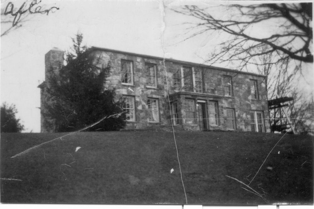 |
| Early 1900's? | 1930s - "Before" | 1930s - "After" |
Clickable Maps
1685 Mansfield Center Map
In 1880 T.S. Cummings published "Present Mansfield ("Centre")" which contained a comparative map of 1685 and 1879.
There were no houses in 1685 but the map shows that Joseph Hall bought the fifth home lot in 1694 at which
time it is possible he built this house.
1685 1790 Mansfield Center Map
Zalmon Storrs (1779-1867) provided information for a set of two maps, one "As remembered in 1790" and the other
"Buildings in 1865." The 1790 map associates Theophilus Hall with this house. Title and genealogical research
show that Theophilus Hall (1752-1822) owned this house from 1774 until his death.
1790 1857 Map
In 1857, William. C. Eaton and H. C. Osborn prepared a wall map of Tolland County. The map shows this house as the property of A. Hall.

1857 District I 1865 Mansfield Center Map
Zalmon Storrs (1779-1867) provided information for a set of two maps, one, 1790, "As remembered in 1865" and the other
"Buildings in 1865." The 1865 map associates Wm B. Crain and an erection date of "100 yrs +" with this house.
Research shows that William B. Crane (d.1897) owned this house from 1861 to 1867.
1865 1869 Map
In 1869, an atlas of Tolland and Windham counties was compiled by O. W. Gray.
The atlas's Mansfield map shows the general location of the house; the District I map and the
Mansfield Center map indicate this house as the property of E. Stedman.


1869
Mansfield1869
District I1869
Mansfield
Center1879 Mansfield Center Map
In 1880 T.S. Cummings published "Present Mansfield ("Centre")" which contained a comparative map of 1685 and 1879.
The 1879 map shows this house next south of the Dodd house but does not associate the house with a name.
Research shows that Ellen M. Lockwood owned the house in 1879.
1879
Additional Material
Variant Names:
District I House 32, The Fifth Home Lot, Joseph Hall House, E[paphas Hoyt] Sheldon House (1869), Old Uncle Hall House, Ferguson's Folly
1953 Courant Article:
In 1953, the Hartford Courant published an article about this house.

Federal Census Records:
Beginning in 1790 a federal census of inhabitants was taken every ten years.
Research shows the following information about the owners of the house.
Title History:
In 1993, George Waller prepared an exhaustive title history from the late 17th century
to the mid 20th century for this house and property, originally known as the "5th Home Lot."Barn:
A barn on this property is included at Historic Barns of Connecticut
Books, Articles, Memoirs, Biographies, Genealogies, Diaries, Etc:
The early Mansfield Hall family is in WorldConnect. Brothers William, Joseph, and Benjamin Hall resided in Mansfield.
This file was created: 26 Jan 2010 by George Waller
This file was updated: 9 Feb 2010 by George Waller