 Estate Map
This estate map was prepared for Edward Chute, Esq. of Bethersden by Ambrose Cogger in 1628. It was discovered by Dr. William Cock in a cupboard in the Sessions House at Maidstone. The map is now preserved in the County Archives Office. According to Sir John Winnifrith: "The 76 parcels of land totalled 570 acres. In addition, Edward Chute owned considerable woodland in the Heron Wood. The land included all of the fields round Hornes Place to the east and west of the Ashford Road, apart from what is now Gusborne farm. This block included the mill (shown on the map), the mound of which still remains, as does the lane leading to it which is also marked on the map. He owned some land on both sides of Moor Lane and - the largest block - on both sides of the Tenterden road beyond the crossroads as far as the present Tenterden and Reading sewers. All this land was very suitable to let for farming tenants. Unfortunately, none of the field names are shown. These would have been given in the book mentioned in the legend at the bottom of the map."
Blanche Delaney Chute
Photo that appears on her Oxfam International Youth Parliament profile, 2004.
Charles Chute
"Marist Brothers High School, Suva produced so many champion sporting and athletic teams - here's a great rugby team from the 1960's Champion Marist Junior team of 1969."
Back row: Allan Apted, Waqa, Jone Tabuya, George Dyer, Colin Thaggard, Francis Ram, Glenn Ah Sam.
Middle Row: Luke Chan, Sefarano Fatiaki,Sawani Koroi, Jone Manaseitava, John Tavu, Michael Bing, Albert Sanday, Fesaitu Tipo.
Front row: Brother Placid (coach), Charles Chute, Sela Macanawai (Captain), Anthony Loo, Chris Sue, Epeli Nasome.
Photo by Chris Sue (November 2004).
 Blanche Delaney Chute
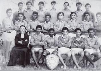 Charles Chute