
|
Columbia County Cemeteries |
Arlington Cemetery aka Caldwell United Presbyterian. Est. 1850. St. Hwy 60 to County Q, south on Q about 1 mile, cemetery is on the east side of the road. Tombstone transcription by Pat Asmussen and Joan Woodward 2001. Contributed by Anna Mae Axness Arlington Prairie Norwegian Lutheran Cemetery. Cemetery is at intersection of Smokey Hollow Road & Bissell, South of Highway 60. Tombstone transcription by Joan Woodward & Pat Asmussen July 2002. Contributed to this site by by Anna Mae Axness Arlington Evangelical United Brethren Cemetery. EST 1867. South of Highway 60 on WIBU Rd for 1 mile, East on Kampen Rd, Cemetery is 1/2 mile on South side of Kampen Rd. Tombstone transcription by Joan Woodward 2001, updates by Anna Mae Axness
CALEDONIAAmerican Indian burials (unnamed cemetery) - Township 12, Range 8, Section 8 State Road 78 West of Interstate 90/94 to Shanks road, south on Shanks to Krejchik Road. German Methodist Evangelical Cemetery - Take State Road 33 to County Road W, take W to Wall, go west on Wall to Owen Park Road. Cemetery is at intersection of Wall & Owen Park Rd. Section 30, T12N, R8E Indian Farm Cemetery (Small) a/k/a Zastrow Cemetery - State Road 78 west of Interstae 90/94 to Indian Farm Road. South on Indian Farm Road. Cemeteries are on east and west sides of roadway. Indian Farm Cemetery (Large) - State Road 78 west of Interstate 90/94 to Indian Farm Road. South on Indian Farm Road. Jerrison Cemetery - St. Rd 78 to Old Hwy U, south on Old U, cemetery is on west side of road--.2 mile north of Shanks Rd. McLeish Family burial - Section 4 in Township 11 North, Range 8 East - Take State Hiway 78 south of Portage. The Marvin McLeish farm is on the West side of Highway 78. Rubin/Guenther Cemetery - Take County Road U to area between Interstate 90/94 and Ziehmke Road. Cemetery on south side of road. On Robert Grotzke farm, County Rd. U. Saint Camillus Novitiate Cemetery a/k/a Durwards Glen Cemetery - State Road 78 west of Interstate 90/94 to Durwards Glen, north on Durwards Glen to McLeisch, cemetery on west side. Saint Paul's Evangelical Lutheran Cemetery - (picture) On Owen Park Road, follow directions to German Methodist (above) but continue on Owen Park to where it meets County Road W again. Cemetery is at intersection. Shanks Cemetery - Take State Road 78 west of Interstate 90/94 to Shanks Road, go south on Shanks, cemetery is on west side of road. Unnamed cemetery - in Township 10, Range 12, Section 6 Unnamed cemetery - In Township 12, Range 8, Section 7 Unnamed cemetery - In Township 12, Range 9, Section 19 Welsh Calvinistic Methodist Cemetery (Pioneer) - Intersection of State Road 33 and County Road W COLUMBUSHillside Cemetery - Lewis St. on the north side of the city of Columbus Saint Jerome's Catholic Cemetery - Next to Hillside Cemetery COURTLAND / CAMBRIACourtland Township (Lost Lake)Annunciation Cemetery Cambria Cemetery - Intersection of State Road 146 and Cemetery Road just south of the Village of Cambria Courtland Methodist Cemetery - Intersection of County Roads D & DG, just south on DG on east side of road DEKORRA / POYNETTEDekorra Cemetery - West of intersection of County Roads V & B, turn left on Hemlock Road, cemetery on east side. Established 1843, organized Dec. 16, 1875. Barb Ferguson updated list 2005 from cemetery records, typed by Anna Mae Axness Dekorra Lutheran (Norwegian) - County Road CS to V, South on V to Corning ST. Turn left at Molitor's Resort. Top of hill. By Mr/Mrs. Wm. Donald Jellings in 1980. Updated 2005 by Deb Jensen. Typed by Anna Mae Axness Hastie Cemetery Cty Hwy J North of CS on William Bender farm in 2007. Private property, no Tresspassing. This 2000 transcription is by Joan Woodward & Margo Holzman. Additions & corrections are from James Wallace in 2007. Organized here by Anna Mae Axness. Note: This cemetery has been called the Rockwell Cemetery and the District #4 Cemetery. It was next to the District #4 school house. On all the old plat records, the cemetery is shown in Section 17. The truth is, the school house was in Sect. 17 and the Cemetery is in Section 20, just across the section line. Organized here by Anna Mae Axness Hillside Cemetery - Veterans - U.S. Highway 51, Poynette. In City of Poynette East side of Hiway 51. Earlier
transcription by Mr. & Mrs. William Donald Jellings. 2005
transcription by Joan Woodward and others. Typed here by Anna
Mae Axness
Inch Cemetery - United Methodist Church and Cemetery at the Intersection of US
51 and Cty B, North of Poynette. 1974 transcription by Mr.&
Mrs. Donald Jellings. Transcribed and updated 2005 by Dave
Tamminga. Typed here by Anna Mae Axness. Some information is
from other sources.
Rockwell/Schlicter Family Cemetery - [see Hastie Cemetery]
Saint Thomas Catholic (Klaila) Cemetery - Dekorra Township section 34E, Columbia county Wisconsin. CS toward Interstate. One marker. All graves have been removed to other places except for the Klaila family. Thanks to Joan Woodward.
Contributed to this site by Anna Mae Axness Schofield Cemetery - Two miles north of Poynette on US 51, east side of road. By Mr. & Mrs. Donald Jellings, copied here by Anna Mae Axness Saint Marys Lost Lake Cemetery is at the intersection of U.S. Hwy
73 and Concord/Pete Peak Rd., about five miles south of Randolph.
Mainly old graves of the Irish Catholic pioneer farmers from the area.
Wanderer's Rest Cemetery -technically in Dodge County, but just a
couple miles south on Highway 73 from Lost Lake (Section 6 Calamus
Township), and including families who lived in the Fall River -
Columbus - Lost Lake area, it is a small Methodist burial plot. The
following families are there - Brounk, Bauch, Deglow, Dieckhoff,
Elske, Firary, Fuerstenau, Hempel, Jones, Kopplin, Kruschka, Lange,
Leisemann, Maleck, Parshen, Rehfeldt, Rhode, Schmidt, Seir, Weber,
Woller & Zekalla (Thanks, Bob!).
Bach/Henderson Cemetery - Section 7, West off Cty Rd CX onto Grotzke Rd. Cemetery is on
the South side of Grotzke Rd. between CX & Hiway 51/39.
Old Fort Winnebago Cemetery - On EE just off of State Road 33, east
of Portage Union Soldier Burials (as of 21 May 1887)
Saint Mary's Catholic Cemetery - off of U.S. Hwy. 51 northside of
Portage, turn west on Collins St. Union Soldier Burials (as of 21 May
1887)
Spicer Cemetery - Cty Hwy F to Old River Road to Spicer school, turn left to end of road.
State Rights - The final resting place of a race horse owned by
Chauncey L. Roberts. Click here for the story of this interesting road
side grave.
Fall River Cemetery - just north of the village of Fall River on
County Road D
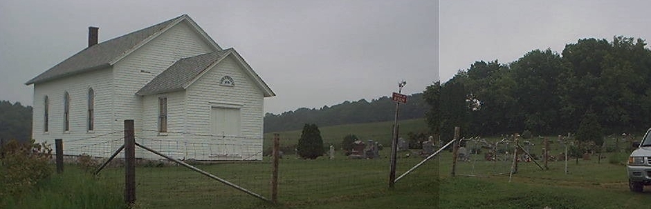
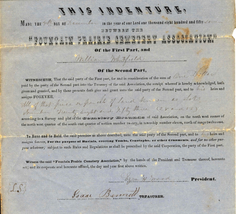
Fountain Prairie Cemetery - 1857. Take highway 16 west of Fall River. Turn
north on Highway 146. About 1 1/2 miles North on 146, cemetery is
on the East side of highway 146.
Saint Stephen's Evangelical Lutheran Cemetery - Intersection of
State Road 146 and County Road Z
Hampden Cemetery - at intersections of County Roads K & DM and
Bradley Road near the Hampden Town Hall
Unnamed cemetery - Township 10, Range 11, Section 8 - [note
from contributor - The Hall Rd Cemetery is the Unnamed
cemetery Township 10, range 11 section 8 that is listed on the
website already. It is still unnamed except that it is located
on Hall Rd. (i.e. Hall Rd. Cemetery). It might also be called
the Bedell/Eldredge cemetery for the people buried there. It
is a private family cemetery from the 1800�s]
Greenwood Cemetery - 1847. At intersection of US highway 51 and State
Road 22, north of Leeds. Transcription by Joan Woodward.
Edited and reformatted by Anna Mae
Axness
Leeds Center Cemetery - Section 14 US highway 51 to State Road 60. Take 60 East crossing St.Rd. 22. Turn right on Kroncke Road. Cemetery is on the east side of the road. Tombstone transcription by Joan Woodward. Edited and reformatted by Anna Mae Axness Spring Prairie Lutheran Cemetery - On County Road C just north of Keyeser and County Road DM. Tombstone transcription by Karen Gullickson 1985, Joan Woodward & Pat Asmussen 2003. Contributed to this site by by Anna Mae Axness Spring Prairie Hauge Cemetery - Est 1848. On County Road C. and the Dane County border. Tombstone transcription from Joan Woodward. Contributed to this site by by Anna Mae Axness Zion Evangelical Lutheran Cemetery - On County Road K between Hopkins Road and US Highway 51 on south side of road. 1981 transcription & church records and Joan Woodward transcription. Contributed to this site by by Anna Mae Axness LEWISTON / PORTAGECummings - State Road 127 to Cummings, north on Cummings to intersection of Cummings, Adney and Anacker Roads Greenwood Cemetery Town of Lewiston, Columbia Co., Wisconsin Hillcrest Cemetery - off of State Road 16 south on Wolfram, over the railroad tracks, cemetery on the west side Martin Family Cemetery - W10851 State Highway 127 St. Michael's Lutheran Cemetery - west from Portage on County Road O to Church Road, turn right, cemetery one-half mile on left St. Paul Lutheran Cemetery - on State Road 127 west of Portage Oak Grove Cemetery - (Oak Grove addendum) on County Road O off of State Road 16 on the west side of Portage. West of Silver Lake Cemetery. Union Soldier Burials (as of 21 May 1887) Silver Lake Cemetery (1857) - take State Road 16 to west side of Portage. Turn on County Road O. Cemetery is on south side of O. Union Soldier Burials (as of 21 May 1887)
Unnamed (Bendixon Family Cemetery) - On Cummings road about half way between St.Rd 127 and Adley Rd., on the south east side of the road. It is off the road in the trees and very hard to find. One big stone and a few broken smaller stones. Unnamed (Grossman) LODICounty Line Cemetery (Columbia/Dane) The Chrislaw Family burials � Section 16 & 17 of Lodi township. S 1/2 of the SW 1/4 of Section 17. Mount Pleasant Cemetery - in Lodi Saint Patrick's Catholic Cemetery - on County Road J south of County Road V, north of Wells Rd. Pioneer/Bartholomew - T10N R8E S22, only one stone remains Okee Cemetery - T10N R8E S8, No Stones Remain LOWVILLE / RIOSouth Lowville Cemetery - County Trk CS east of Poynette Ohio Cemetery (1853) - turn on Rio Street off of State Road 16, right on Cemetery Street
Rocky Run Protestant - On County Road B east of intersection with State Road 22 MARCELLONCole - Fuller Cemetery - State Road 33 east of Portage to County Road EE, northwest on EE to Monthey Road, north on Monthey to cemetery Comstock Cemetery - take State Road 22 north of Pardeeville to County EE, turn west of EE to Comstock Rd. Cemetery is on northwest corner of intersection. Henion Cemetery - Located East of Portage near the Cole/Fuller Cemetery on EE on what was the family farm. Marcellon Cemetery - East of Pardeeville on State Road 44 North Marcellon Baptist Cemetery - take State Road 22 north of Pardeeville to County CM, go west of County CM to cemetery just before Monthey Rd. NEWPORT / WISCONSIN DELLS (KILBOURN)Calvary Cemetery - Wisconsin Dells/Kilbourn. Records are kept by St. Cecilia's Catholic Church. Newport Norwegian Evangelical Lutheran Cemetery - on State Road 16 at Peterson Rd. (south side) next to the Newport Norwegian Evangelical Lutheran Church. There is a marker stating that it is the site of the Moe Settlement. (Thanks, Jill!)
Spring Grove - Wisconsin Dells/Kilbourn. Records are kept by City of Wisconsin Dells (608) 254-2012, city building. OTSEGO / DOYLESTON / RIOBonnet Prairie Norwegian Lutheran Cemetery - Rio, State Road 16 to County Road C, south on C to Sampson Rd., east on Sampson, cemetery is on north side of road
Doylestown Village Cemetery - Doylestown [aka Doyle Family Cemetery]
Otsego Cemetery St. John's Lutheran Cemetery - north of Doylestown on County A St. Joseph's Catholic Cemetery - Rio, southeast side of Rio on State Road 16, east of County C St. Patrick's Catholic Cemetery - Doylestown, next to church Vangen Family Unnamed Lutheran cemetery - range 11 section 12 PACIFIC / PORTAGEBurial at 720 West Pleasant Street, Portage Wisconsin Pacific Cemetery - near the intersection of U.S. Hwy 51 and State Road 16 south of Portage. Cemetery is on the west side of the road and north of the power plant. Unnamed - range 9 section 15 Unnamed American Indian burials - range 9 section 15. RANDOLPH / FRIESLANDBlaen Y Cae (a/k/a Engedi Cemetery Mach Pelah Blaen Y Cae) - orignally founded by Welsh Calvinistic Methodist congregation. Blaen Y Cae is roughly translated as "Foremost the Field." Records available at Beaver Dam Public Library. Cemetery is off of State Road 73 on Blaencae Road, near Dodge County line in section 12.
Krastetter/Busse/Kumby/Lake Sarah Cemetery Tombstone Photos Lake Sarah Cemetery - Lutheran Randolph Center / Friesland Cemetery - section 22
Randolph Public Cemetery - section 36 the records for the Randolph Cemetery are at the Randolph Town Hall, the telephone number is (920) 326-4600. Saint Gabriel's Catholic Cemetery - section 36. Records available at Beaver Dam Public Library. Saint Mary Visitation Catholic Cemetery - section 8 Unnamed - section 8 SAUK COUNTYSaint John's Lutheran Cemetery - Hwy 78 & DL
SCOTTAmish - Fenske Rd. North of E Lyons - abandoned, section 19 North Scott - section 18 Pleasant Hill/Inglehart - State Road 33 to Inglehart Road, north on Inglehart, next to St. Paul Evangelical Church. Portage Prairie Cemetery - State Road 33 to Inglehart Road, north on Inglehart, cemetery is on west side just passed Friesland Road Rosedale Presbyterian Cemetery - On State Road 33 next to Rosedale Presbyterian Church SPRINGVALEUnnamed Burial - NW, SW, SE of section 29 Unnamed cemetery - section 7. Welsh Prairie Cemetery - 1857 - SE, NW, SW, NE of section 12. Jones Rd. off Co B Unnamed - section 16 Unnamed - section 17 Unnamed - also section 29 Nehemiah Rogers - on Jennings Road between County SS and Old B Road about midway on the North side of the road in a small circle of oaks. It is the burial site of Nehemiah Rogers, who died there in 1853. It is marked by a fairly modern stone erected by a descendent of Nehemiah. Stone reads: Nehemiah Rogers Died Mar. 21, 1853 Great Grandfather of Wm. Jennings. (Thanks, Earl!) WEST POINTGarden Bluff Cemetery - Section 14, Cty Rd J, North side of the road. Garden Bluff Cemetery Tombstone Photos Knight Cemetery - in Sec. 34. No stones remain. WYOCENA / PARDEEVILLECounty Home Cemetery (Old Cemetery) - Small plot on Crawford St. in Wyocena, other burial plots were on County Home grounds. Home/cemetery is no longer in existence. Home opened in 1858 as Columbia County Poor-House. Pardeeville Cemetery - take State Road 22 into village (Main St.), turn west on Morton St. Cemetery is down two blocks, turn right on Cemetery St. Rocky Run Catholic (St. Augustine's) Cemetery - Take State Road 22 to Gorman Road, turn east on Gorman, cemetery is on south side of road.(in section 33).
Wyocena Cemetery - take State Road 22 into Village (Washington St.), turn East on Polk St. Cemetery runs along East side of Polk St. Unnamed - section 16. |
 Copyright Notice: All files on this site are
copyrighted by their creator and/or contributor. They may be linked to
but may not be reproduced on another site without specific permission
from Tina Vickery [[email protected]]
and/or their contributor. Although public information is not in and of
itself copyrightable, the format in which they are presented, the
notes and comments, etc., are. It is however, quite permissable to
print or save the files to a personal computer for personal use ONLY. My very special thanks to Holly Timm for the creation of the WIGenWeb Columbia County graphic. The use of the Penny Postcard in the title graphic is used with permission of the Penny Post Cards a USGenWeb Archives Web Site. Copyright Notice: All files on this site are
copyrighted by their creator and/or contributor. They may be linked to
but may not be reproduced on another site without specific permission
from Tina Vickery [[email protected]]
and/or their contributor. Although public information is not in and of
itself copyrightable, the format in which they are presented, the
notes and comments, etc., are. It is however, quite permissable to
print or save the files to a personal computer for personal use ONLY. My very special thanks to Holly Timm for the creation of the WIGenWeb Columbia County graphic. The use of the Penny Postcard in the title graphic is used with permission of the Penny Post Cards a USGenWeb Archives Web Site. |