 |
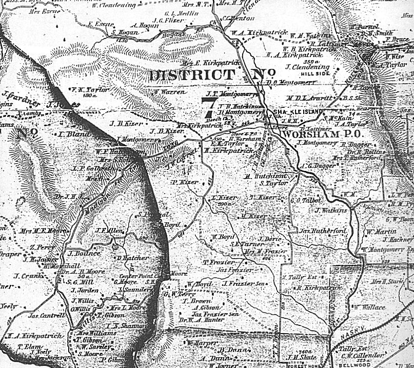
1878 Sumner County, TN Map
District 7
Transcribed and submitted by Joyce Stark Blocker, Linda Carpenter,
Eileen McCarey, Diane Payne, & Danene Vincent
© September 1999
|
|
| Last Name | First Name | Location | Comments |
| Avaritt | M. D. L. | 7 | |
| B. | A. J. B. | 7 | |
| Benton | C. C. | 7 | |
| Blackmore | A. J. | 7 | |
| Bloodworth | W. M. | 7 | |
| Boyd | W. | 7 | |
| Boyd | W. | 7 | |
| Brown | I. | 7 | |
| C. | J. | 7 | |
| Clark | W., Rev. | 7 | |
| Clendening | J. | 7 | Hillside |
| Clendening | W. | 7 | |
| Clendenning | J. S. | 7 | |
| Clendenning | M., Mrs. | 7 | |
| Clendenning | T. B. | 7 | |
| Clendenning | W. F. | 7 | |
| Davie | J. | 7 | |
| Dorris | E. A | 7 | |
| Dorris | E. A. | 7 | |
| Dorris | J. | 7 | |
| Dorris | M | 7 | |
| Dugger | A. G. | 7 | |
| Dugger | R. | 7 | |
| Dyer | M., Miss | 7 | |
| Escue | E. | 7 | |
| Escue | Mrs. | 7 | |
| Flizer | J. G. | 7 | |
| Frazier | Jas | 7 | |
| Frazier | Jas, Sen. | 7 | |
| Frazier | Jas, Sen. | 7 | |
| Frazier | M., Mrs. | 7 | |
| Frazier | T. | 7 | |
| G. | J., Mrs. | 7 | |
| Garrett | J. W. | 7 | |
| Garrett | J. W. | 7 | |
| Garrett | P., Mrs. | 7 | |
| Gibson | A. | 7 | |
| H. | J. R. | 7 | |
| H. | N., Mrs. | 7 | |
| H. | T. | 7 | |
| Hackney | J. | 7 | |
| Hearn | J. B. | 7 | 74 or 14 acres |
| Hogan | A. | 7 | |
| Hogan | S. | 7 | |
| Honeycutt | T. | 7 | |
| Honeycutt | W. | 7 | |
| Hosale | C., Mrs. | 7 | |
| Hosale | W. | 7 | |
| Hunter | W. A., Dr. | 7 | |
| Hutchinson | J. B. | 7 | |
| Hutchison | J. R. | 7 | |
| Hutchison | M. | 7 | |
| Hutchison | W. F. | 7 | |
| J. | B. | 7 | |
| Jones | J. | 7 | |
| K. | A. | 7 | |
| K. | J. | 7 | |
| King | A. | 7 | |
| Kirkpatrick | E., Mrs. | 7 | |
| Kirkpatrick | H. | 7 | |
| Kirkpatrick | Mrs. | 7 | |
| Kirkpatrick | R. | 7 | |
| Kirkpatrick | W. A. | 7 | |
| Kirkpatrick | W. A. | 7 | 350 acres |
| Kirkpatrick | W. B. | 7 | |
| Kizer | I. | 7 | 30 acres |
| Kizer | J. B. | 7 | |
| Kizer | J. B. | 7 | |
| Kizer | L. | 7 | 200 acres |
| Kizer | M. | 7 | |
| Kizer | P. | 7 | |
| Kizer | T. | 7 | |
| Lattimer | D. | 7 | |
| Lattimer | R. | 7 | |
| Lawless | J. A. | 7 | |
| M. | W. | 7 | |
| Maddox | ? | 7 | |
| Maddox | W. W. | 7 | |
| Martin | W. | 7 | |
| McKain | S. | 7 | |
| McMutry | L. | 7 | |
| Medlin | G. L. | 7 | |
| Montgomery | D. | 7 | |
| Montgomery | D. O. | 7 | |
| Montgomery | J. | 7 | |
| Montgomery | J. T. | 7 | |
| Montgomery | W. | 7 | Estate |
| Moore | 7 | ||
| Murray | S. D. | 7 | |
| Perry | L. W. | 7 | |
| Pybus | R. M. | 7 | |
| Rollins | R., Dr. | 7 | |
| Rutherford | Jas | 7 | |
| Rutherford | T., Mrs. | 7 | |
| T. | M., Mrs. | 7 | |
| T. | M., Mrs. | 7 | |
| Talbot | G. O. | 7 | |
| Tally | Z. | 7 | Estate |
| Taylor | E. K. | 7 | 180 acres |
| Taylor | F. K. | 7 | 180 acres |
| Taylor | J. A. | 7 | |
| Taylor | R. | 7 | |
| Taylor | S. | 7 | |
| Terry | G. W. | 7 | |
| Turner | S. E. | 7 | |
| Utley | Major | 7 | |
| Warren | W. | 7 | |
| Watkins | J. | 7 | |
| Watkins | W. | 7 | |
| Watkins | W. M. | 7 | |
| Williams | C., Miss. | 7 | |
| Worsham | R. | 7 | |
| Wyatt | M., Rev. | 7 |
| Place Name | Location |
| B. S. Sh. (Blacksmith Shop) | 7 |
| Beech Ch. (Church) | 7 |
| Cal Bapt Ch (Calvary Baptist Church) | 7 |
| Ch. (Church) | 7 |
| Clendenning Branch (of Drakes Creek) | 7 |
| Col. Bapt. Ch (Colored Baptist Church) | 7 |
| Cooper Sh (Shop) | 7 |
| Drakes Creek | 7 |
| Hillside | 7 |
| Hogans Creek (of Drakes Creek) | 7 |
| Long Hollow Pike | 7 |
| New Hope Ch (Church) | 7 |
| Rules Branch | 7 |
| S. H. (School House) | 7 |
| S. S. Mill (Saw Mill) | 7 |
| Shackle Island | 7 |
| Store | 7 |
| Store & P.O. | 7 |
| White Hill | 7 |
| Worsham P. O. | 7 |
View the District 7 North map
View the District 7 South map
You MUST use your BACK key to return to this screen.
Return to Sumner County Main Page
 |