 |
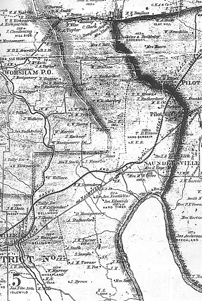
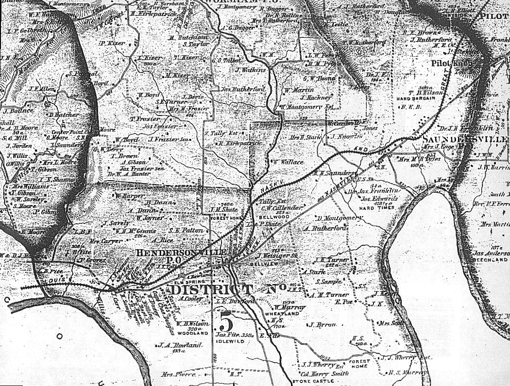
1878 Sumner County, TN Map
District 5
Transcribed and submitted by Joyce Stark Blocker, Linda Carpenter,
Eileen McCarey, Diane Payne, & Danene Vincent
© September 1999
|
|
| Last Name | First Name | Location | Comments |
| Allen | H. | 5 | |
| B. | R. K. | 5 | |
| B. | W. | 5 | |
| Beasley | W. | 5 | |
| Bell | S., Mrs. | 5 | |
| Bezell | E. | 5 | |
| Bledsoe | M. | 5 | |
| Brown | B. K. | 5 | |
| Brown | R. | 5 | |
| Bruce | Jas. | 5 | |
| Burford | L. E. | 5 | |
| Byrum | J. | 5 | |
| Cage | J., Mrs. | 5 | |
| Callender | C. W. | 5 | Bellwood, 325 acres |
| Cardwell | W. | 5 | |
| Carr | J. | 5 | |
| Caryer | Mrs. | 5 | |
| Clark | C. | 5 | |
| Clark | Mrs. | 5 | |
| Cooley | A. | 5 | |
| Curtis | J. | 5 | Listed as McCurtis |
| Douglas | Chas., Capt. | 5 | |
| Douglas | R. | 5 | |
| Doxey | S. | 5 | |
| Doxey | W. D. | 5 | |
| Dunn | A. | 5 | |
| Dunn | B. | 5 | |
| Dunn | Jno. | 5 | |
| Dyson | T. E. | 5 | |
| Edwards | Jas | 5 | Hard Times, 123 acres |
| Ellis | T. | 5 | |
| F. | J., Dr. | 5 | 190 acres |
| F. | L. B. | 5 | |
| F. | W. | 5 | |
| Fite | Jas | 5 | Idlewild, 350 acres |
| Fite | L. B. | 5 | |
| Fite | L. B. | 5 | 306 acres |
| Franklin | J. H., Dr. | 5 | |
| Franklin | Jas, Dr. | 5 | 31 acres |
| Freeman | L. | 5 | |
| Groves | P. | 5 | |
| Guthrie | I. N., Jr. | 5 | |
| Harper | W. | 5 | |
| Hay | Mrs. | 5 | |
| Jones | C. | 5 | |
| Jones | J. | 5 | |
| Joyner | W. | 5 | |
| K. | J. | 5 | |
| Kemp | J. | 5 | |
| Knowles | J. | 5 | |
| Leslie | G.? | 5 | |
| Lyles | M. R., Mrs. | 5 | 100 acres |
| Lyles | Mrs. | 5 | 36 acres |
| Martin | J. G. | 5 | |
| McCurtis | J. | 5 | Probably Curtis |
| McGinnis | W. H. | 5 | 226 acres |
| Mills | B. | 5 | |
| Mills | D. F. | 5 | Vaniler, 400 acres |
| Montgomery | D. | 5 | |
| Murray | R. S. | 5 | |
| Murray | W. | 5 | Wheatland, 199 acres |
| Patton | S. E. | 5 | |
| Pierce | Mrs. | 5 | |
| Poe | E. | 5 | |
| Rice | A. | 5 | |
| Roberts | W & D. J. | 5 | |
| Robin | J. | 5 | |
| Roland | J. A. | 5 | 133 acres |
| Roland | J. A. | 5 | Elm Spring |
| Rolling | S. | 5 | |
| Rutherford | A. | 5 | |
| Rutherford | A. A. | 5 | |
| Rutherford | J. | 5 | |
| Rutherford | T. W. | 5 | |
| S. | H. | 5 | 170 acres |
| S. | H. | 5 | 30 acres |
| Sample | H. | 5 | |
| Sample | S. | 5 | |
| Saunders | H. H. | 5 | |
| Saunders | W. W. | 5 | |
| Savely | J. | 5 | |
| Savely | W. | 5 | Poverty Hill, 225 acres |
| Scott | Mrs. | 5 | |
| Shute | J. M. | 5 | Forest Home, 740 acres |
| Shute | L & P. | 5 | |
| Smith | H. | 5 | 130 acres |
| Smith | Harry, Col. | 5 | Stone Castle (Rock Castle), 2000 acres |
| Stark | A. | 5 | |
| Stark | W., Mrs. | 5 | |
| Stewart | A. | 5 | |
| Sumner | G. W. | 5 | |
| T. | H. | 5 | |
| T. | J. M. ? | 5 | 107 acres |
| Talley | J. T. | 5 | |
| Talley | 5 | Estate | |
| Taylor | R. A. | 5 | |
| Terrell | H. & R. | 5 | |
| Turner | A. M. | 5 | |
| Turner | J. H. | 5 | 222 acres |
| W. | W. B. | 5 | |
| Wallace | W. | 5 | |
| Walton | W. B. | 5 | |
| Watson | G. W., Dr. | 5 | |
| Weisiger | J., Sr. | 5 | Bellview, 225 acres |
| Wherry | J. J. | 5 | Forest Home, estate |
| Willis | S. G. | 5 | |
| Wilson | Mrs. | 5 | |
| Wilson | T. B. | 5 | Hard Bargain, 500 acres |
| Wilson | W. B. | 5 | Woodlawn, 320 acres |
| Wise | W. | 5 |
| Place Name | Location |
| B. S. Sh. (Blacksmith Shop) | 5 |
| Beech Hill Academy | 5 |
| Bellview | 5 |
| Bellwood | 5 |
| Col. Bapt. Ch (Colored Baptist Church) | 5 |
| Col. M. E. Ch (Colored Methodist Episcopal Church) | 5 |
| Cumberland River | 5 |
| Douglas Chapel | 5 |
| Drakes Creek | 5 |
| Drakes Pond | 5 |
| Forest Home | 5 |
| Hard Bargain | 5 |
| Hard Times | 5 |
| Idlewild | 5 |
| Louisville, Nashville and Great Southern Railroad | 5 |
| Pilot Knob | 5 |
| Poverty Hill | 5 |
| Rock Castle (Note: see Stone Castle) | 5 |
| Rules Branch | 5 |
| S. H. (School House) | 5 |
| S. S. (Saw Mill) | 5 |
| Sanders' Ferry | 5 |
| Station Camp Creek | 5 |
| Stone Castle (Note: Rock Castle) 2000a - Col. Harry Smith - Settled in 1780 | 5 |
| Vanlier | 5 |
| Walton's Ferry | 5 |
| Wheatland | 5 |
| Woodland | 5 |
View the District 5 North map
View the District 5 Middle section map
View the District 5 South map
You MUST use your BACK key to return to this screen.
Return to Sumner County Main Page
 |