

Click the images below to enlarge
Click the images below to enlarge
 |
 |
 |
 |
| For a larger 273 kb image, click here. | For a larger 281 kb image, click here. | For a larger 282 kb image, click here. | For a larger 266 kb image, click here. |
The article that accompanied the panoramic sketch.
Newport, the oldest and most picturesque watering-place in this country, is situated in the southern extremity of an island in Narraganset Bay, known in old Indian times as the island of Aquidneck. It is the largest of a cluster of islands, is fifteen miles long, and about three and a half in breadth. The first white settlement on its shores was made about 235 years ago, by John Clark and a little band of persecuted brethren seeking an asylum from the religious intolerance of Massachusetts. Roger Williams, whom they first visited at Providence, directed their attention to the waters of Narraganset Bay, and advised them to take up their abode on its shores. He also offered his services in procuring them a settlement; and through his influence with the two great and powerful sachems of Narraganset, Canonicus and Miantonomoh, a deed of Aquidneck and other islands of the bay was procured in the name of Mr. Coddington and friends in March, 1638. The original charter of this colony was brief and unique, and shows the earnest religious character of the founders. It was as follows:
The magnificent situation of Newport on the shores of a commodious harbor created in the minds of its early founders visions of future greatness. They expected it to become the metropolis of the country, and for many years its prosperity seemed to justify this expectation. But the reverses it suffered during the Revolutionary war put an end to these dreams, and it was not until about 1830 that its prosperity began to revive. About that time it became known as a pleasant watering-place. Families from the Southern States, attracted by its genial climate, began to visit here during the summer, living entirely in boarding-houses. There were three at that time: one known then as the "Jews House," kept by Charles Whitfield, a lame man; the Bellevue House, which was the old Brindley mansion; and "Potters," occupied mainly by the Friends at Yearly Meeting time. The first Ocean House was built about 1832, but was destroyed by fire in 1841, and rebuilt on the same site during that year. At this time the city occupied only a few streets near the water front, and cottages had not been thought of. The first sale of real estate was made about that year to an Englishman named Robert Johnson, who bought about twenty acres of the Easton Farm, situated between the Bath Road and Narraganset Avenue. He did not build, but occupied a building already on the land. About the same time Alfred Smith, who has become very prominent in the advancement of the citys interests, induced a Mr. Sears to buy twenty-two and a half acres of the same farm for $10,000. Within the past year one-quarter of that purchase has been sold for $88,000. William Beach Lawrence, of New York, also bought about that time sixty acres at Ochre Point for $12,000, which is now worth half a million.
It was not until 1851, however, that Newport became a really popular and fashionable watering-place. Up to that time most of the cottages had been erected in the vicinity of the Bath Road and toward the south from that neighborhood. In that year the Bailey Farm, below the Ocean House, was sold for $22,000, and in the following year Bellevue Avenue was opened as far as "Baileys Beach." Then, as the rush came, cottages were put up right and left along Bellevue Avenue. The city began to wake up to its growing importance, and was induced to lend its help toward needed improvements. George Bancroft built here; Daniel Parish, Lindley Murray Hoffman, James Phalen, and Edward Curtis, of New York, General George Cadwallader, of Philadelphia, and James T. Rhodes, of Providence, built about the same time.
As the celebrity of the place increased a great impetus was given to building summer residences. The simple style observed in the earlier cottages was exchanged for ornate styles of architecture. Swiss chalets, French villas, and English cottages sprang up as by magic; and probably in no other place in America has there been such lavish expenditure of money in the search fro comfort and luxury. With all the transfers of property, there has been very little speculation, most of the land having gone to bona fide purchasers, who have built and settled upon it. The rise in the value of land has been constant and rapid. The Bailey Farm of 140 acres was sold in 1851 for $22,000, or a little over $150 per acre. The first sales from this land were made at the rate of $500 per acre: a few weeks since several acres of it were sold for $9000 per acre. Other recent sales indicate still higher rates of increase in the valuation of eligible sites for cottages.
The favorite localities for building were, until with a few years, in the vicinity of Bellevue Avenue and along the Bath Road; but recently a tract of land further to the south, known as the Gibbes Farm, has come into the market, and is being rapidly bought up and covered with handsome cottages. Within the past year thirty-five new cottages have been projected, and some of them finished, representing an investment, including enlargements and improvements to others, of about $700,000. Some of the Newport cottages are rented every summer at rents varying from $3000 up to $8000 for the season, $5000 being about the average. In a different way from what they imagined, the dreams of the old Newport settlers have thus partly come true. Though partially eclipsed by Long Branch, Newport is still the metropolis of summer resorts. Its picturesque situation, delightful climate, and the charm of shady groves, in which its latest rival is still lacking, must for many years to come give it the preference with those who value these advantages above the attractions of a purely fashionable resort.
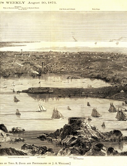
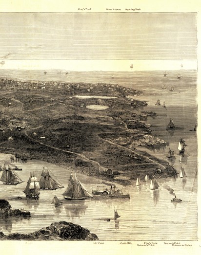
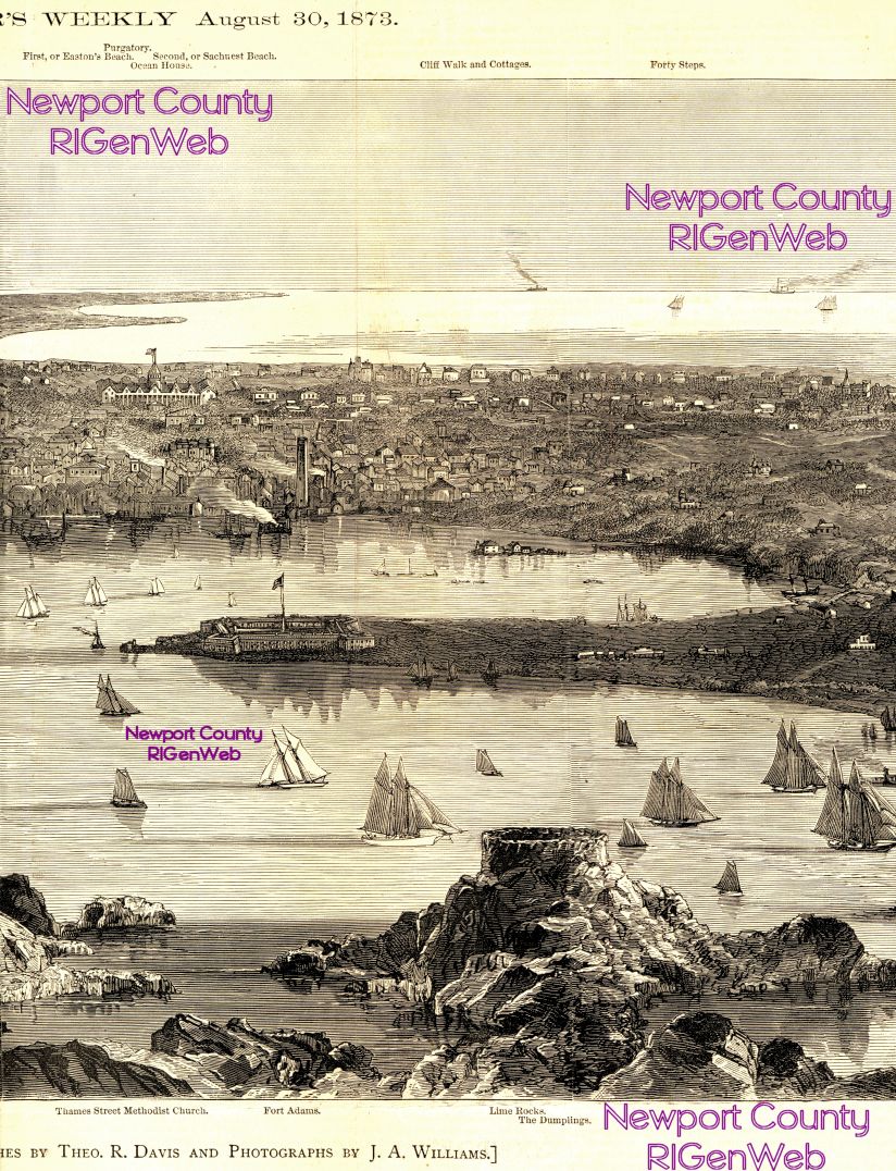
Our picture gives a birds-eye or panoramic view of this beautiful watering-place, and shows its varied attractions to great advantage. The sketch was taken from a point near the "Dumplings," the picturesque mass of rock which looms up in the foreground, crowned by the ruins of an old Martello tower. Just beyond is seen Fort Adams, with its extended lines of earthworks. To the left is Torpedo Island, formerly Goat Island, where experiments with submarine torpedoes are carried on under the supervision of United States naval officers. Still further to the left is the well-known Long Wharf, or steamboat landing. The entrance to the harbor is shown on the right of the picture, and extending beyond it are seen the picturesque indentations of the seaward shores. The town proper lies in the middle distance, and just beyond it rise the cliffs, with their long lines of elegant cottages facing the sea. Still beyond these stretch the two beaches which form the bathing-grounds, and which open directly upon the sea. The high tower nearly in the centre of the picture is that of the Ocean House, from the top of which may be obtained a magnificent panoramic view of the town and its picturesque surroundings. It is hardly possible to imagine a more beautiful or more attractive view.
 No
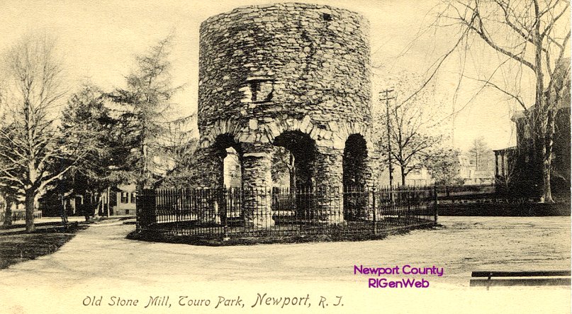
visitor should leave Newport without seeing the celebrated old Stone Tower,
about which antiquarians have raised such a dust of controversy. Unfortunately
it is too small an object to appear distinctly in our picture, but its
locality is marked. It stands in Touro Square, just to the left of the
Atlantic Hotel. The structure consists of a circular wall of great strength,
built upon arches which spring from eight round and massive pillars. These
bear evidence of having once been covered with a thick coating of cement,
portions of which still remain. These pillars are composed of flat, irregularly
shaped stones, laid in cement as hard as the stones themselves. No capitals
crown the pillars, and they are referable to no other of architecture,
yet considerable skill was shown in their structure. Above them the arches
are well turned. Not a stone appears to have crumbled or decayed, and the
enormous weight resting on them has never forced them a hairs-breadth
from their original position. The top of each of the eight pillars projects
considerably beyond the lower edge of the wall of the tower which they
support, and their bases rest on larger stones. The tower is open on all
sides between the pillars, and is roofless. Three openings, which may have
been windows, are seen on the north, west, and south portions of the tower
wall. In the eastern part, just above the arches, is a recess which may
have been used as a fire-place, as a chimney ascends in the interior of
the wall. There are also cavities in which rafters probably rested in by-gone
ages. One blackened beam still stretches from wall to wall; with this exception,
the interior of the structure is entirely bare. The circumference of this
remarkable ruin is exactly eighty-one feet; the pillars are three feet
in circumference and about ten feet high. The tower itself rises twenty
feet above the pillars, making the entire elevation about thirty feet.
No
visitor should leave Newport without seeing the celebrated old Stone Tower,
about which antiquarians have raised such a dust of controversy. Unfortunately
it is too small an object to appear distinctly in our picture, but its
locality is marked. It stands in Touro Square, just to the left of the
Atlantic Hotel. The structure consists of a circular wall of great strength,
built upon arches which spring from eight round and massive pillars. These
bear evidence of having once been covered with a thick coating of cement,
portions of which still remain. These pillars are composed of flat, irregularly
shaped stones, laid in cement as hard as the stones themselves. No capitals
crown the pillars, and they are referable to no other of architecture,
yet considerable skill was shown in their structure. Above them the arches
are well turned. Not a stone appears to have crumbled or decayed, and the
enormous weight resting on them has never forced them a hairs-breadth
from their original position. The top of each of the eight pillars projects
considerably beyond the lower edge of the wall of the tower which they
support, and their bases rest on larger stones. The tower is open on all
sides between the pillars, and is roofless. Three openings, which may have
been windows, are seen on the north, west, and south portions of the tower
wall. In the eastern part, just above the arches, is a recess which may
have been used as a fire-place, as a chimney ascends in the interior of
the wall. There are also cavities in which rafters probably rested in by-gone
ages. One blackened beam still stretches from wall to wall; with this exception,
the interior of the structure is entirely bare. The circumference of this
remarkable ruin is exactly eighty-one feet; the pillars are three feet
in circumference and about ten feet high. The tower itself rises twenty
feet above the pillars, making the entire elevation about thirty feet.
By the inhabitants of Newport this singular structure is known as "The Old Stone Mill." For years antiquarians and historians have disputed as to its probably origin, and the question still remains undecided. A citizen of Newport, who died some years ago at the reputed age of one hundred and six years, declared that in his boyhood the mystery was as great as it is at present. Mr. George C. Mason, in his sketches of Newport and its Environs, says of it:
"It has been conjectured by many that this building must have been the work of the Northmen when settled in America, and taken by some to be proof irrefragable that here is to be sought the famous Vineland discovered by Biorn and his companions, and visited after by adventurers from Iceland many centuries before the voyage of Verrozano and discoveries by the Cabots. More recent and authentic inquiries, and particularly the recovery of the will of Governor Benedict Arnold, executed in 1677, have determined the character of the structure, which was no doubt erected as a mill for grinding Indian corn and other grain soon after the settlement of the colony in 1639. This mill, built in the style then common in England, was placed upon land either originally allotted to, or which soon came into possession of, the family of Arnold, and is formed of the same material which is used in the stone walls which now inclose and divide Rhode Island proper, and that, at its discovery and settlement, was loosely strewn over a greater part of its surface."
Professor Rafn, on the contrary, in the Mémoires de la Société Royal des Antiquares du Nord for 1838-39, declares for its great antiquity, and expresses his belief that it was erected at a period not later than the twelfth century. For our part, notwithstanding the sarcastic remarks of Cooper, who believed it to be undeniably a mill, we are inclined to side with Professor Rafn. Longfellow was content with this authority, and one of his most beautiful poems, The Skeleton in Armour, connects the tower with a romantic Scandinavian legend. The Viking heros reply to the poets apostrophe gives what all imaginative people should be willing to accept as the true theory of the origin of the tower. The Viking, our readers will remember, had run away with a kings daughter, and boldly set sail toward the west:
"Three weeks we westward bore,
And when the storm was oer,
Cloud-like we saw the shore
Stretching to leeward;
There, for my ladys bower,
Built I this lofty tower,
Which, to this very hour,
Stands looking seaward!
"There lived we many years:
Time dried the maidens tears;
She had forgot her fears;
She was a mother!
Death closed her mild blue eyes;
Under that tower she lies!
Neer shall the sun arise
On such another!"
 The
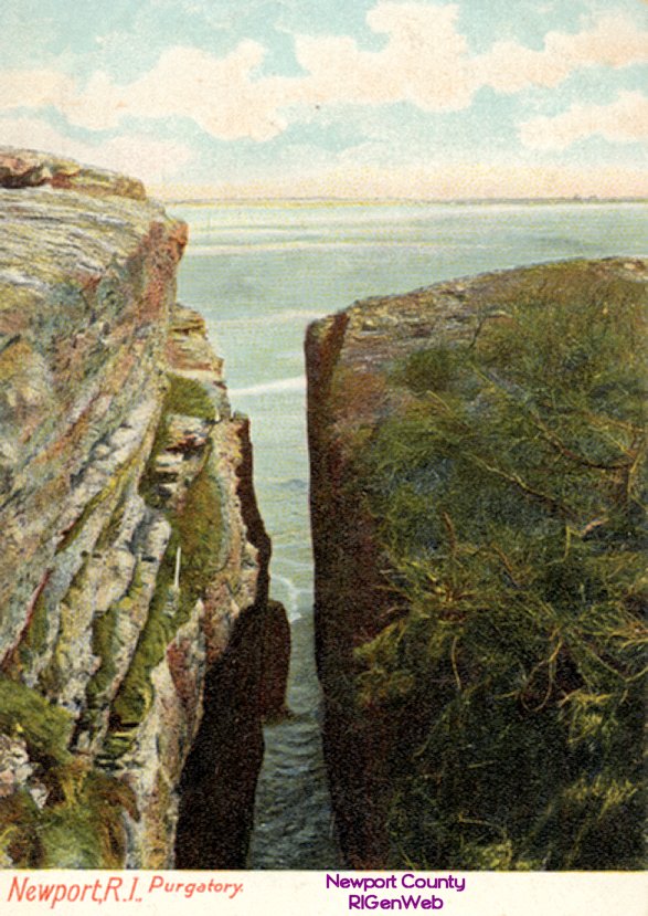
vicinity of Newport abounds in picturesque and romantic scenery, and is
the favorite resort of many of our most eminent artists. The genial Kensett
found there the inspiration for many of his beautiful pictures. One of
the most celebrated spots is one which bears the unromantic name of "Purgatory,"
a wild narrow chasm or cleft in the solid wall of a seaward cliff. Standing
on the edge of this chasm, the spectator gazes down to a strip of dark
water forty feet below. The sides are dark, smooth, and nearly perpendicular,
the chasm, about twelve feet wide at the top, gradually narrowing toward
the base. A stone thrown into the rift rebounds from side to side with
a hollow sound, and then sullenly plunges into the dark and fathomless
waters beneath. Just outside the chasm the blue waves are ever dashing
and tossing; within, the waters subside into a smoothness and silence which
excite a strange sense of awe and mystery. Viewed from the sea, much of
the romance of the place is lost. Many legends are connected with the chasm,
and in one of them, appropriately enough, considering the name, his Satanic
Majesty plays a prominent part.
The
vicinity of Newport abounds in picturesque and romantic scenery, and is
the favorite resort of many of our most eminent artists. The genial Kensett
found there the inspiration for many of his beautiful pictures. One of
the most celebrated spots is one which bears the unromantic name of "Purgatory,"
a wild narrow chasm or cleft in the solid wall of a seaward cliff. Standing
on the edge of this chasm, the spectator gazes down to a strip of dark
water forty feet below. The sides are dark, smooth, and nearly perpendicular,
the chasm, about twelve feet wide at the top, gradually narrowing toward
the base. A stone thrown into the rift rebounds from side to side with
a hollow sound, and then sullenly plunges into the dark and fathomless
waters beneath. Just outside the chasm the blue waves are ever dashing
and tossing; within, the waters subside into a smoothness and silence which
excite a strange sense of awe and mystery. Viewed from the sea, much of
the romance of the place is lost. Many legends are connected with the chasm,
and in one of them, appropriately enough, considering the name, his Satanic
Majesty plays a prominent part.
 Of
the other localities about Newportof its beautiful drives, shady groves,
and attractive beacheswe have not space to speak in detail, nor can we
describe many interesting features of the town itself, with its narrow
winding streets, hardly wider than lanes, its churches, public buildings,
and Revolutionary relics. We must content ourselves with only a passing
reference to "Paradise," a long and beautiful grove of sycamore-trees skirting
the foot of a rocky hill, and to "Hanging Rock," one of the great features
of Sachuest Bay, which Berkeley made his out-door sanctum, and where he
is supposed to have written the greater part of his Minute Philosopher.
His house is still standing near the beach at this place, about three miles
from the State-House in Newport, a little to the northward of what is called
the Green End Road. For a full account of these and other interesting localities
and objects in and around Newport our readers are referred to the Hand-Book
of Newport and Rhode Island, published by Mr. C. E. Hammett, of Newport,
to which we are indebted for some of the material for this account of one
of the most attractive watering-places in America.
Of
the other localities about Newportof its beautiful drives, shady groves,
and attractive beacheswe have not space to speak in detail, nor can we
describe many interesting features of the town itself, with its narrow
winding streets, hardly wider than lanes, its churches, public buildings,
and Revolutionary relics. We must content ourselves with only a passing
reference to "Paradise," a long and beautiful grove of sycamore-trees skirting
the foot of a rocky hill, and to "Hanging Rock," one of the great features
of Sachuest Bay, which Berkeley made his out-door sanctum, and where he
is supposed to have written the greater part of his Minute Philosopher.
His house is still standing near the beach at this place, about three miles
from the State-House in Newport, a little to the northward of what is called
the Green End Road. For a full account of these and other interesting localities
and objects in and around Newport our readers are referred to the Hand-Book
of Newport and Rhode Island, published by Mr. C. E. Hammett, of Newport,
to which we are indebted for some of the material for this account of one
of the most attractive watering-places in America.
Return to Newport County Rhode Island Home Page
https://sites.rootsweb.com/~rinewpor/maps/