Pictures & Postcards of Hamilton County
INCLINES OF CINCINNATI
| Centennial History of
Cincinnati and Representative Citizens By Charles Theodore Greve Biographical Publishing Company 1904 |
| THE INCLINED PLANES |
| pages 1007-1008 |
| The Mount Auburn Inclined Plane was the first of these remarkable structures (so characteristic of Cincinnati) to be built. This was opened to the public in 1872 and ran from the head of Main street the length of 900 feet to a point on the crest of the hill known as Mount Auburn, 312 feet higher. After the terrible accident of October 15, 1889, which resulted in the releasing of a car at the head of the incline and its rushing with lightning like speed to the foot, carrying death and destruction with it, this plane was remodeled in 1890 at a cost of $200,000. After the control of this line had passed into the hands of the consolidated system, this plane was demolished and abandoned. The second inclined plane was that on Price Hill built by the Price Hill Inclined Plane Company. This was on Eighth street and was opened on July 13, 1875; it ascended 800 feet with separate tracks for passenger and freight traffic to an elevation of 350 feet. This was built at a cost of $300,000. It is no longer used by the street cars. A year later the Bellevue Inclined Plane at the head of Elm street was opened. It was remodeled in 1890 but reconstructed in 1892 at a cost of $375,000. Its length is 980 feet and its elevation 300 feet. In 1877 came the opening of the Mount Adams Inclined Plane, which was remodeled in 1880 and reconstructed in 1892 at a cost of $300,000. Its length is 945 feet and it ascends to an elevation of 268 feet. The latest to be built was the Fairview Inclined Plane which was opened in 1894. This cost $200,000. Its length is 633.8 feet and elevation, 210 feet. From the summit of each of the hills attained by these inclined planes can be had a view of the city which lies spread out like a map at the observer's feet. |
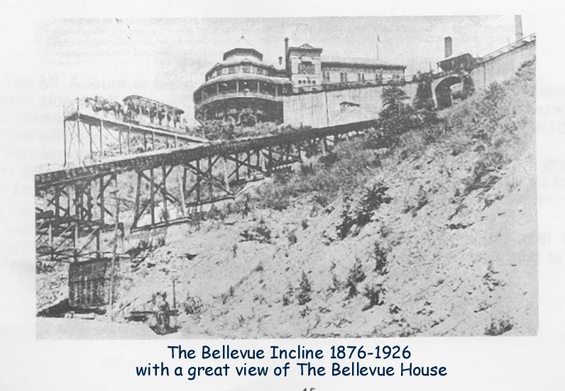
| Bellevue
Incline History 1876-1926 Contributed by Bob O'Brien. Extracted from his Cincinnati History of the Inclines, compiled by Bob O'Brien. Officially, the Bellevue Incline was the Cincinnati & Clifton Inclined Plane Railroad, which was built at the head of Elm Street at McMicken Avenue in 1876 and went to Ohio Avenue. The ornate Bellevue House beckoned the city dwellers and visitors to ascend the incline and see the view from the vantage of the veranda. It lasted until 1926. |
 |
|
| Bellevue
Incline 1876-1926 Bellevue-Clifton-Elm Street-Ohio Avenues 980-1020’ in length, 395’ in height Hauling Capacity: 20 tons submitted by Patti Graman |
 |
|
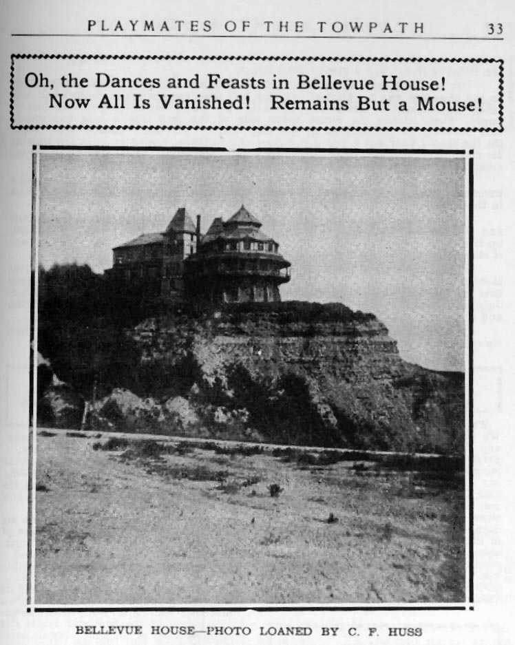
| Bellevue
House submitted by Patti Graman |
 |
|
|
|
||
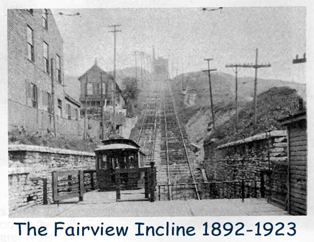
| Fairview
Incline AKA "Crosstown" 1892-1923 Length: 632.5-700 feet 207' of length was on trestle Height: 34.44-35 feet high Fairview Incline did not go to a resort. Contributed by Bob O'Brien. Extracted from his Cincinnati History of the Inclines, compiled by Bob O'Brien. This was the only incline constructed for streetcars and ended up as passenger only. All others started out as passenger and were converted to street cars except Price Hill that remained passenger. It went from McMicken Avenue (Browne Street) to Fairview Avenue. In 1921 because of badly needed repairs it was declared unsafe for streetcars and stationary bodies were mounted for foot passengers. The Streetcar Company built a road around Fairview Hill to replace the incline. The road was completed in 1923 and the incline shut down on December 24, 1923. |
 |
|
 |
||
|
|
||
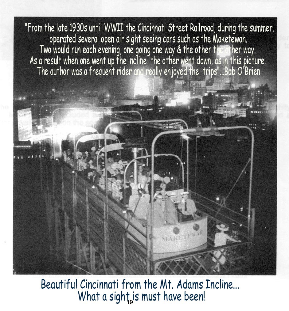
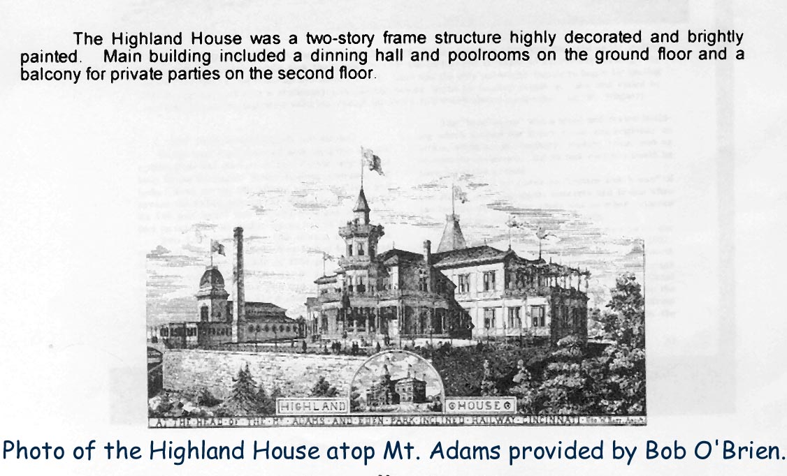
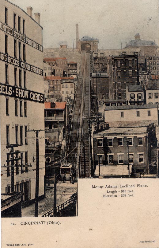
| Mount
Adams Incline Contributed by Bob O'Brien. Extracted from his Cincinnati History of the Inclines, compiled by Bob O'Brien. This was the longest lived of the inclines, the most well known and was finally abandoned in 1948. It was constructed for streetcars and did accomodate wagons and in later years automobiles. The Zoo-Eden car used the incline and carried many to the Zoo over the years-as this was the favorite way of getting there. The reasons the cars stopped using the incline was because the bridge over the entrance to Eden Park had deteriorated and the cars were no longer allowed to cross it. For about a year after the buses used it and on April 16, 1948 it was shut down. Automobiles could use it and it was a short and interesting way to Eden Park. The author used it many times. The fare was 25 cents for car and driver and 5 cents for each passenger and pedestrians were 5 cents each. At the top of the incline was the Highland House, a brilliantly lighted showplace where even political meetins and conventions could be held. As the end of "gay Nineties" period approached, the Highland House fell victim to the Sunday closing laws and finally was razed in 1895 but the incline continued for another half a century. Along with the Price Hill Incline this was the most photographed incline ... the pictures tell the story. |
 |
|
 |
||
 |
||
| Mount
Adams Incline 1876-1948 945’ – 975’ in length 230-270‘ in elevation submitted by Patti Graman |
 |
 |
|
|
||
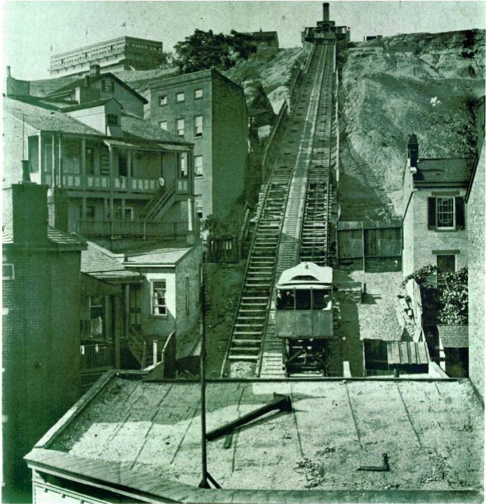
| Mt.
Auburn Incline & Zoo Car (or Main Street Incline) 1871-1898 Submitted by Bob O'Brien Extracted from Cincinnati History of the Inclines, compiled by Bob O'Brien. The Mt. Auburn or Main Street Incline was the first of the incline planes built to scale the rugged side of Mt. Auburn, heading directly north of the densely populated basin. It was built for passengers and was completed and started hauling passengers in 1872. In 1878, it was rebuilt with open platforms for horse cars. This incline was unique among the Cincinati inclines in that the grade was not the same all the way up. The bottom part was much steeper than the top. At top was the very popular Lookout House. In 1889 the incline was electrified and the system started to haul electric cars. The Main Street incline hauled cars up and down Mt. Auburn until 1898 when the section of the Cincinnati Inclined Plane Railway from downtown was sold to the Cincinnati Street Railway and Vine Street Hill became the route to town. |
 |
|
| Mt.Auburn
Incline 1871-1898 length 960 feet; 312 feet high Went to the Lookout House Resort Contributed by David Heller, Reading, Ohio From; "Cincinnati Streetcars No.2 The Inclines" by Wagner and Wright. Page 29. The first of five inclined plane railways in the city, the Main Street Incline scaled the rugged side of Mt. Auburn, heading north of the densely populated basin. This scene is before 1878 when the cabs were rebuilt to haul horsecars. The Lookout House is on the left on top of the hill. (Cincinnati Historical Society) |
 |
|
|
|
||
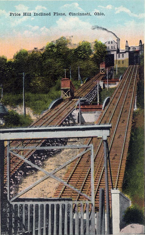
| Price
Hill Inclined Plane 1874-1943 length 800 feet, 350 feet high Went to Price Hill House (No. 525 Price Ave.) Submitted by Bob O'Brien Extracted from Cincinnati History of the Inclines, compiled by Bob O'Brien. This one was unique among Cincinnati's inclines because it was really two inclines. In fact, some people count this as two making a total of six. Also, it remained private and never hauled streetcars. William Price, after whose, father, General Rees E. Price name was given to the hill top location, built it. It was actually two planes built side by side starting at West Eight Street and Glenway Avenue and going up to West Eight Street and Matson Avenue. The first side was built in 1874 and had two cars for passengers. The freight was finished in 1876 and could carry three or four heavily loadd wagons and their teams on open platforms. In its heyday the resort at the top caused horses and wagons to stand to line for blocks waiting their turn to get up the hill. In 1928 the steam engines were replaced by electric motors the only incline to do so. In 1927 the then owner propsed that the Cincinnati Street Railway buy the incline and run the freight side only for buses. Nothing came of it so in Decmeber 1929 the freight plane was finally shut down do the falling off of the number of teams being hauled. The motor truck and the imporvement of the streets brought this about. However, before it shut down it carried buses. By 1943 the passenger side was in need of so many repairs that the Incline Company decided to shut down and so ended the second to last of the inclines. Now only Mt. Adams remained to operate five more years and then they would all pass into history. Postcards submitted by Patti Graman |
 |
|
 |
||
| Offsite
Links |
| From Cincinnati-Transit.net Bellevue Incline Fairview Incline Mt. Adams Incline Mt. Auburn Incline Price Hill Incline |
|
|
| Mount Adams Incline Model |
Back to:
Pictures
Hamilton Co., OH Main Page
This page was last updated
Sunday, 11-Jan-2009 04:29:09 MST
©2007-2009 by Linda Boorom