THE BUILDING OF FORT HAMILTON- ST. CLAIR�S EXPEDITION.

Click to enlarge photo
As early as the year 1749, a company of English traders from Pennsylvania established a trading-house among the TWIGHTEWEE Indians, on the west bank of the Miami River, on the first high ground below where LORAMIE�s canal empties into the river, which they called Pickawillany. This a was the first point of any English settlement in Ohio of which we have any record.
In the fall of the year 1750, the Ohio Land Company* appointed Christopher GIST, of Virginia, an agent to explore the regions west of the mountains. He went to Logstown, on the Ohio River, below Pittsburgh, thence proceeded to the Maumee River, where he found a village of the OTTAWAs, friendly to the French, and a number of WYANDOTs, divided in sentiment. Thence he met George CROGHAN, a deputy sent out from Pennsylvania by Sir William JOHNSON, the British Indian agent. (* footnote: This was not the company which purchased land at the mouth of the Muskingum, but a company composed of gentlemen of Virginia and Maryland, who obtained a grant from the crown of Great Britain, in 1745, for half a million acres, to be taken principally on the south side of the Ohio River, between the Monongahela and Kanawha Rivers.)
In concert they held a council with the chiefs, and received assurances of the friendship of the tribe. Next they passed to the Shawnee towns on the Scioto River, and received assurances of friendship from them, and then came into the Miami Valley. They crossed the Great Miami River, on a raft of logs, in the vicinity of the trading-house, near to where the town of Piqua now is, and there made treaties with the PIQUAs and representatives ofthe WEA Indians. Croghan then returned, and Gist descended the Miami River in a canoe, passing by where Hamilton now is, to the mouth; thence down the Ohio River and over the high lands of Kentucky to Virginia, where he arrivedin May, 1751.
Early in the year 1752, the French having heard of the trading-house on the Miami, sent a party of soldiers from Canada, accompanied by a band of CHIPPEWA and Ottawa Indians as allies to the Miami Indians, demanding the surrender of the English traders, as intruders on French lands. The Miamians refused, a battle ensued, and after a severe fight, in which fourteenof the Miami Indians were killed and others wounded, the trading-house was taken and burned, and the traders either killed or carried away to Canada. From the appearance of the ground and excavations at this place, when the country afterwards became settled, the establishment must have been of considerable extent. The Province of Pennsylvania afterwards made a gift of condolenceto the Miami or Twightewee Indians, in consideration of those slain in defense of the traders.
In the year 1780, Colonel BYRD, an officer in the British service in Canada, with an army of six hundred Indians and Canadians, with two pieces of artillery, made an incursion into Kentucky, and captured RUDDLE�s and MARTIN�s stations, at the south fork of Licking River. The expedition proceeded principally by water, up the Maumee and St. Mary�s Rivers; then crossed to the head waters of the Big Miami, and descended it to the mouth; thence up the Ohio to the mouth of Licking River, and up that stream to the forks. After having accomplished the object of their expedition they returned by the same route. As they appeared before Ruddle�s station, on the twenty-second of June, they must have descended the Miami River in the month of May, or early in June.
In the year 1785 there was a fort built at the mouth of the Great Miami River, called Fort FINNEY. It was situated on the level flat below the point of the hill, on ground subject to be overflowed at high-water. Judge SYMMES states, in his pamphlet of "Terms of Sale and Settlement of Miami Lands", published at Trenton in the State of New Jersey, in 1787, that the fort was standing at that time.
In the Summer of 1785 George Rogers CLARK; General Richard BUTLER, of Pennsylvania (who was killed in St. Clair�s battle, on the fourth of November, 1791); and General Samuel Holden PARSONS, of Connecticut (who was afterwards one of the judges of the Northwest Territory), were appointed commissioners to hold a treaty with the Indians, at the mouth of the Great Miami River. It was with considerable difficulty that the Indians couldbe induced to assemble and brought to treat at all. But after some difficulty a treaty was concluded between the commissioners, and signed on the thirty-first day of July, 1786. But the advantages derived from this agreement were transitory. The Indians could not be prevented from outbreaks whenever it suited their purposes, and as soon as the whites appeared inOhio warfare followed.
The impression has generally prevailed that Judge John Cleves Symmes and his party were the first white persons who explored the Miami Valley. This idea is incorrect. As early as the year 1785, three years before the landing of Judge Symmes, a portion of the bottom lands of the Great Miami River were explored up as far as Hamilton, and opened, and , marks made to designate the most eligible spots for the purpose of establishing preemption rights, by a party from Washington County, Pennsylvania. One of that company, John HINDMAN, who afterwards lived a short distance from Hillsborough, Ohio,gives an account of the expedition, as follows:
�My father, John HINDEMAN, was a native and resident of Lancaster county, Pennsylvania, where I was born in 1760, and at the age of twenty years left that neighborhood for Washington County, where I remained four years. In the month of March, 1785, I left the State of Pennsylvania, taking water at the mouth of Buffalo Creek, with a party consisting of William WEST , John SIMMONS, John SEPT, and old Mr. CARLIN and their families. We reached Limestone Point (now Maysville) in safety, where we laid by two weeks. The next landing we made was at the mouth of the Big Miami. We were the first company that had landed at that place. The Indians had left two or three days before we landed. We found two Indians buried, as they were laid on the ground, a pen of poles built around them, and a new blanket spread over each one. The first landing we found was near the mouth of Whitewater.
Soon after we landed the Ohio raised so as to overflow all the bottoms at the mouth of the Big Miami. We went over, therefore to the Kentucky side,and cleared thirty or forty acres on a claim of a man by the name of TANNER, whose son was killed by the Indians some time afterward, on a creek which now bears his name. Some time in May or June we started to go up the Big Miami, to make what we called improvements, so as to secure a portion of the lands, which we selected out of the best and broadest bottoms between the mouth of the river and where Hamilton now stands.
We started a north course, and came to Whitewater. Supposing it to be the Miami, we proceeded up the creek; but Joseph ROBINSON, who started from the mouth of the Miami with our party, and who knew something of the country, from having been taken prisoner with Colonel LAUGHERY and carried through it, giving it as his opinion that we were not on the main river, we made a raft, and crossed the stream, having the misfortune to lose all our guns in passage. We proceeded to where Hamilton now is, and made improvements whenever we found bottoms finer than the rest, all the way down to the mouth of the Miami. I then went up the Ohio again to Buffalo, but returned the same Fall, and found Generals
New York, with characteristic magnanimity, had previously given to the Union her lands in the Far West, acquired by treaty with the Indians,and sanctioned by England. To Pennsylvania shortly after she gave a port on Lake Erie, and to Massachusetts several millions of acres of acres of land inthe western part of the State, running from Seneca Lake to Lake Erie. Massachusetts yielded up her claims to the Northwestern Territory, though borne out by her charter, and the influence of these examples, combined with the persuasions of the other States, finally and reluctantly wrung from Connecticut and Virginia concessions which rendered the settlement of Ohio possible. These States were bought off; the other States gave their lands away.
Connecticut claimed by virtue of her charter, granted by the crown of Great Britain. The State of Virginia claimed as well under her charter as by the rights of conquest under Colonel George Rogers Clark, in the year 1778, while it remained under the jurisdiction of Great Britain.
The States that had no vacant lands remonstrated against those claims as unjust and inequitable. They contended that, as the war had been sustained, and the independence of the country acquired, by the blood and treasure of all the States generally, everything that had been wrested from the crown of England in the struggle belonged to the United States, in their confederate capacity, as a matter of right, and should be held for their equal and joint benefit. There was considerable excitement on that subject at the time, and propositions were made in some of the newspapers of the day advising the destitute States that had no unappropriated lands within the limits of their charter to seize on portions of these vacant lands for their own use.
To allay the ferment, Congress made strong appeals to the justice and patriotism of the States holding these claims to make liberal cessions to Congress, for the common benefit of the Union. On the 20th April, 1784, Congress adopted the following resolution:
WHEREAS,Congress, by their resolution of September 6, 1780, having thought it advisable to press upon the States having claims to the Western country a liberal surrender of a portion of their territorial claims; by that of the 10th of October, in the same year, having fixed conditions to which the Union should be bound on receiving such cessions, and having again proposed the same subject to the States, in their address of April 18,1783, wherein, stating the national debt, and expressing their reliance for its discharge on the prospect of vacant territory in aid of other resources, they, for that purpose, as well as to obviate disagreeable controversies and confusions, included in the same recommendation a renewal of those of September 6 and October 10, 1780, which recommendations have not yet been compiled with.
"Resolved, That the same subject be again presented to the attention of the United States; that they be urged to consider that the war being now brought to a happy termination by the personal services of our soldiers, the supplies of property by our citizens and loans of money by them, as well as from foreigners, these several creditors have a right to expect that funds shall be provided on which they may rely for the indemnification; that Congress still consider vacant territory as an important resource, and that, therefore, the said States be earnestly pressed, by immediate and liberal cessions, to forward those necessary ends and to promote the harmony of the Union." (footnote: "Old Journals of Congress," Vol. IV, p.392)
The requisition of Congress was complied with by the State of Virginia. The Legislature of that State, on the 2d of January, 1781, resolved that they would yield to the Congress of the United States, for the benefit of the State, all their rights and claims to lands northwest of the Ohio River, on certain conditions, mentioned in the act. The Congress by their act of the 13th of September, 1783, agreed to accept the cession on the conditions named, and the Legislature of Virginia, by their act of the 20th of October, 1783, authorized their delegates in Congress to make the conveyance on the terms agreed on.
Accordingly, on the first day of March, 1784, a deed was executed, by which the State of Virginia ceded to the United States all her right and title to the territory northwest of the River Ohio, reserving the land lying between the Little Miami and Scioto Rivers, to satisfy bounties for the Virginia troops upon the continental establishment in the American Revolution, and also a tract at the Falls of the Ohio, reserved as compensation for the services of General George Rogers Clark.
On the 14th of September, 1786, * the State of Connecticut granted to the United States her claims to Western lands with the reservation of a strip "beginning at the completion of the forty-first degree of north latitude, one hundred and twenty miles west of the western boundary line of the Commonwealth of Pennsylvania, as now claimed by the said Commonwealth, and from thence by a line to be drawn north parallel to, and one hundred and twenty miles west of, the said west line of Pennsylvania, and to continue north until it comes to forty-two degrees two minutes north latitude". This is the district on Lake Erie known by the name of "The Connecticut Reserve". (footnote: "American State Papers, Public Lands," Vol. I, p.87)
The Congress of the United States established a Board of Treasury, and authorized and empowered them to contract with any person or persons for the sale of public lands. And on the 20th of May, 1785, Congress passed "An ordinance for ascertaining the mode of disposing of lands in the Western territory,"* which ordinance directed the public lands to be surveyed and laid off into townships of six miles square, by lines running due north and south, and others crossing these at right angles east and west, and each township to be subdivided into thirty-six sections, of one mile square each. Section number 16 in each township to be reserved and dedicated for the maintenance of public schools within the township, and sections number 8, 11, 26, and 29 to be reserved for future disposition. (footnote: "Old Journalsof Congress," Vol. IV, p. 520; "Land Laws of the United States," Vol. I,p.349.)
Seven ranges of townships were directed to be surveyed and laid off, extending west from the western boundary line of the State of Pennsylvania.
On the thirteenth day of July, 1787, the Congress of the Confederation adopted the celebrated ordinance for the government of the territory of the United States northwest of the River Ohio, * which was the first step towards establishing a civil government, and throwing around it the first protection of law and preparing it for social existence. That ordinance affirmed and perpetuated by the Federal Constitution adopted in 1788. (footnote: "Old Journals of Congress," Vol. IV, p. 752; "Land Laws of the United States," Vol. I, p.356.)
The first sale made by the Board of Treasury, pursuant to the powers vested in them, was a tract of one million five hundred thousand acres at the mouth of the Muskingum River to "the Ohio Company." It was bounded on the east by the western boundary of the seven ranges, then in the course of being surveyed, and extending down the Ohio River and westwardly for quantity.
Manasseh CUTLER and Winthrop SARGENT were the agents on behalf of the directors of the company of associates, who negotiated with the Congress of the United States and the Board of Treasury for the purchase of the tract of land, as appears by a communication made by them dated New York, July 26, 1787. However, the agreement was not finally completed and the contract closed until the twenty-seventh day of October, in the same year.* According to the contract, in each township was reserved section number 16 for the maintenance of public-schools; section number 29, for the support of religion; and sections number 8, 11, 26, for future disposition. There were also given, within the tract, two townships of land for the support of a university, on which the Ohio University has since been established in Athens. (footnote: "Land Laws of the United States," Vol. I, p. 364.)
The Ohio Company, however, failing to make full payment for the whole amount due for their lands, consequently received a patent for only as much as they had paid for, being nine hundred and sixty-four thousand two hundred and eighty-five acres, instead of one million and a half.* However, a donation of one hundred thousand acres to actual settlers was given by Congress, to relieve the company of furnishing the donation entirely from their own lands, as they had proposed to do. *2 (footnote: "Pioneer History," by S.P. Hildreth, p. 306.) (*2 footnote: "Land Laws of the United States," Vol. I, p. 364.)
The second settlement begun in Ohio was the one at Columbia, and from this the other places in Hamilton and Butler Counties are offshoots. Shortly after, a third party landed at Cincinnati,and a fourth at North Bend. These were all onSymme�s purchase, and were settled by men of energy and ability. At Fort Washington, since Cincinnati, a fort was raised for defense of the people, and at the other places block-houses were built. It was soon,however, found to be necessary to have posts in advance, and to this need may be ascribed the building of Fort Hamilton, on the site of the present city of Hamilton. In January, 1790, General Arthur St. Clair, then governor of the Northwestern Territory, arrived at Cincinnati.
In the year 1788, a party of men were sent by Judge Symmes to explore the ground between the Miamis. They passed up through the country, from the mouth of the Great Miami River, to near where Middletown now is, thence traversed the country east to the Little Miami River, and down that stream to the Ohio.
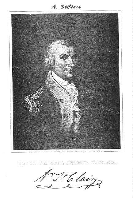
The army was raised and assembled at Fort Washingtown, where Cincinnati now stands, in the ensuing Summer. On the 7th of August the troops which had arrived, except the artificers and a small garrison for the fort, moved to Ludlow Station, on Mill Creek, five miles from Cincinnati. On the 17th of September, 1791, a portion of the army was led by Colonel William DARKE to the Miami River at Hamilton, which had been previously reconnoitered, and encamped on the prairie about half a mile below where the town now is. In a day or two, General St. Clair, who had been necessarily detained at Fort Washington, arrived, selected and laid out the site and commenced building Fort Hamilton, designed to cover the passage of the river, to serve as a place of deposit for provisions, and to form the first link in the chain of posts of communication between Fort Washington and the objects of the campaign. The site selected for the fort was immediately on the bank on the river. The upper part of the fort was nearly opposite to where the east end of the bridge now is, and the lower part where the United Presbyterian meeting-house now stands. The ground was then thickly covered with timber, and the first thing necessary to be done was to clear off the site, and to cut the timber to the distance of two or three hundred yards all around.
The fort was a stockade work, the whole circuit of which was about one thousand feet, throughout the whole extent of which a trench about three feet deep was dug to set the pockets in, of which it required about two thousand to inclose the fort. It is not trees taken promiscuously from the forest that will answer for pickets; they must be tall and straight, and from nine to twelve inches in diameter (for these of a larger size are to unmanageable); of course, a few suitable trees are found without going over a considerable space of woodland. When found, they were cut down, trimmed of their branches, and divided into lengths of about twenty feet. They were then carried to the ground. Although some use was made of oxen in drawing the timber, the woods were so thick and encumbered with underbush that it was found to be the most expeditious method to carry it. The pickets were then butted, with an ax or cross-cut saw, that they might be placed firm and upright in the trench. Some hewing upon them was also necessary, for there are few trees so straight that the sides of them will come in close contact when set upright. A thin piece of timber, called a ribbon, was run round the whole, near the top of the pickets, to which every one of them was pinned with a strong wooden pin, without which they would have declined from the perpendicular with every blast of wind, some hanging outwards and some inwards, which would have rendered them in a great measure useless. The earth thrown out of the trench was then returned and strongly rammed to keep the pickets firm in their places. About two thousand pickets were alsoset up on the inside, one between every two of the others, to intercept any balls which might pass between the outer pickets. The work being then inclosed, a shallow trench was dug outside about three feet distant, to carry off the water and prevent the pickets from being moved by rain.
The fort was situated on the first bank of the river; the second bank, where the court-house now stands, being considerably elevated, andwithin point-blank shot, rendered it necessary to make the pickets, particularly along the land side, of a height sufficient to prevent an enemy from seeing into the area, and taking the side next the river in reserve. Four good bastions were made of trunks of trees. One stood at the northeast angle of the fort, in High Street, south of where the post-office now is. On this was raised a high platform, to scour the second bank with artillery. Another platform was also raised on the bastion towards the river to command the ford (which was then opposite the lower part of the town) and the river for some distance up and down.