Twin Monuments & Other Variations in the County
[Reference: 1880’s maps and
interviews]
Revised Monday, May 28, 2012
This trail is currently non-existent, as farming has removed the route; or
where portions are still visible, the route is closed
to travel. It would appear that soon after the new boundary for the Crow Indian
Reservation was established, identification of this trail’s existence
became evident from the surveyor’s field notes. They plotted pieces of
the trails on large section survey topo maps during
the 1879 through 1920 time periods. In joining these trail segments together, a
composite series of routes can be clearly established. The main trail, referred
herein to as “Monument Trail” leads from the Crow Indian
Reservation’s Mee-Tse-Tse Trail that follows
Pryor Creek, due west to a high point in the lower center of the South Hills
area of Yellowstone County, and then to other locations in the region,
including Brazwell Summit and Coulson (Billings). Portions of the trails were
used for stage and freight travel. Very little information has been recorded
about the trails, and the only evidence of their existence is the old maps and
some local homesteader’s biographies and comments.
A trail
generally to in stories of freighting days followed the high ridges along Blue
Creek and down McCormick Hill. Pryor Agency was reached by either the Monument
Creek trail or by crossing the Fourth of July and Plum Creeks. In examining the
Monument Trail, one can only wonder if the Rock Cairns that were in the area
marked the trail, or were only rock piles created by idle sheepherders.
 General Trail Descriptions
Following
completion of the wagon bridge (the Old South Bridge on Washington Street)
across the Yellowstone
River
and a more accessible road from Wyoming in 1894, travel
increased through the South Hills Area (Blue Creek Area shown in yellow
outline.) In years prior to this, it had taken mail up to two weeks to reach
the distance of approximately ninety miles to the rural areas of Northern Wyoming.
Other
trails crossed the Yellowstone River
at fords between Blue Creek, Duck Creek and Spring Creek. They went up Conway
Hill (Hillcrest Road
today), Duck Creek or Spring Creek, continuing through Cottonwood
country. From there travelers made their way to Pryor, Edgar,
Silesia or the Pryor Gap. The Blue
Creek trail was a favorite route for the Crow Indians during summer and autumn,
which was Fair time in Billings.
Fruit grew abundantly in that valley in early days, especially watermelon and
cantaloupe. Tales have been told of the fruit being transported by wagonloads -
quite often without the growers' per- mission! Many stories have been written
and told about the freighters narrow escapes from harrowing experiences and
elements while they were hauling supplies at the time the railroad tunnel was
being constructed in the Pryor Gap (1900). Freighters going to the Pryor Gap
Area used the trail through Cottonwood Country, and those going to Pryor Creek
carrying supplies either to the Indian Agency or to the construction crews for
the railroad tracks down Pryor Creek traveled the Blue Creek Trail.
Historic
accounts tell of a major Indian Trail, which ran down Pryor Creek confluence with
the Yellowstone River.
Some of the accounts include information on battles between the Crow Indians
and other tribes for possession of the fine hunting grounds. The Pryor Creek
Trail branched in several areas with routes to the Yellowstone
down both Blue Creek and Bitter Creeks. Once the Yellowstone
was reached near Huntley, then trails led down river to Mountain Lions Lodge
(Pompey's Pillar) where an easy river ford was located. Other trails and fords
were located at the mouth of the Bitter Creek, Blue Creek and the Clark's Fork
River. The valleys of the
Yellowstone, Clark's Fork and Pryor Creek were
used because they provided not only outstanding hunting for tribal peoples, but
also sheltered areas for horses and camps during the winter. The Bozeman Trail
is the best-known wagon trail in the "Trails and Tales" area from
where this information was extracted to define the maps. First blazed by John
Bozeman and Jake Jacobs in 1864, this road became one of the major paths to the
gold fields of Idaho and Montana
Territories. The Sioux
Indians contested traffic on the trail, and the Military tried to protect the
trail by construction of Forts C.F. Smith, Reno, and Phil Kerney.
After several years of battles the government recognized the right of the Sioux
to use the region and withdrew military protection. The Indians were not the
only hazard along the road however as bands from the disbanded "Montana
Militia" were known to attack emigrant trains. After the Sioux war of the
1876 Fort Custer
was established to the east of the South Hills area. The presence of this fort
resulted in rapid settlement of the region, and the development of a road from Billings
to Fort Custer.
Only a small portion of this trail is in the Yellowstone
County area, and it ran
near where Interstate Highway 90 crosses Pryor Creek toward Hardin. It was
along this route that the stage trail to Hardin and Fort
Custer also ran. A few
early maps of the region indicate that a road to the Big
Horn Basin
or Mee-Tse-Tse in Wyoming
Territory also existed.
Extensive
lines of stone piles or Cairns
mark some of the paths and trails while ruts from the horses and travois may be
observed elsewhere. In other cases the only indication that we have today of
Indian trails are old diaries, reports and legends. A major, and very visible
Indian Trail is located between the Big
Horn Canyon
and Pryor Mountains.
This trail has been called the Sioux Trail, Shoshone Trail and Bad
Pass. A survey of the
literature indicates that its most often used name is the Bad
Pass of the Big Horns or simply Bad
Pass as current
researchers now call it. This trail can be traced for over ten miles from near
Sikes Springs in the Big Horn
Basin to the Dryhead
area north and east of the Pryor Mountains.
Archaeologists have studied over one hundred-seventy stone Cairns associated with the trail. Of thousands reported to have existed before
the turn of the century, an estimated 300 still exist. Artifacts recovered
during various archeological investigations indicate that the Bad Pass Trail and
camps along the route have been used for thousands of years. Since several
tribes traveled between the Big Horn
Basin and the plains north of the
Pryor’s it is likely that they used the Bad
Pass on occasion. The Crow
Indian Plainfeather made one reference to the Bad
Pass Trail. He stated: “... In order to travel the route which has always
been commonly known as Bad Pass,
it is necessary to travel along the Pryor
Mountains to Dry Head Creek and then
south above the headwaters of the small creeks flowing into the Big
Horn River
and into the state of Wyoming.”
This was the trail, which the Indians used to travel from the lands that are
now Big Horn County, Montana,
into the Big Horn
Basin in Wyoming. Bad
Pass was a very rough
trail. The northern end of Pryor Gap contains a short trail similar to the one
in Bad Pass.
A line of Cairns
may be seen running from near shoot-the-arrow rock northward to the edge of a
plowed field. This trail has also been studied by archaeologists and has been
used during the last thousand years into historic times. This trail, like Bad Pass led from the mountains to the
plains south of the Yellowstone, a region which in historic times contained herds of Bison beyond
numbering.
Formation of the Monument Creek Trail
After
the area was opened for settlement, James McCormick and Alphonsus
McCormick, brothers to Paul McCormick, homesteaded land on the plateau
overlooking the Pryor valley in Sections 19 & 30 of Range 26 E, Township 3
South. It is not known when the trail was cut into the sandstone cliffs that
border the reservation, but is believed that they were made by the military
from Fort CF Smith in early 1867 long before Paul McCormick arrived in Billings
in 1891 and became general partner in the Donovan-McCormick general
merchandise company. This was part of the Military Bozeman Trail. Needing
better routes to the eastern and southern area, both the South
Bridge was created, and
better routes established. There are some files in the Herald Gazette that
indicated Dr. Alonzo Allen, had a hand in laying out the routes. In 1908 Paul
sold his business to “Yegen Brothers, Hughes and Yates”. After
retirement he ran an elk & buffalo ranch along the edge of the north rims
in Billings.
During the times that Paul operated his merchandise company, he hauled freight
and seed into the Crow Indian Reservation using Monument Trail. It is believed
that the proper name for the trail would now be “McCormick’s
trail.” A member of the Crow Tribe indicated that Paul also operated a
large sheep franchise in the area between the Big
Horn River
and Pryor Creek. This would be in the same general area as managed earlier by
Charles Bair for the same thing. Paul hauled food supplies and materials to the
sheepherders tending these flocks, along with seed for the Indians, according
to Stan Stevens, Pryor Creek rancher. Stan indicated that this was the
“Bozeman Trail.”
 The
Pryor Creek valley floor is about 200 feet below the rimmed bluffs that border
the eastern edge of South Hills. They are accessible by foot, and at some
places can be breached by horseback. Prior to the 1900’s eastern access
was limited mainly to the Bitter Creek area. This was probably the route that
John Bozeman used in his 1864 expedition to reach the Yellowstone
River from Pryor Creek. To
carry supplies, the wagon trains would have to cross the Yellowstone
River via ferry, north of
the valley entrance (just north of where the railroad currently crosses the
river) and then travel south.
The
Pryor Creek valley floor is about 200 feet below the rimmed bluffs that border
the eastern edge of South Hills. They are accessible by foot, and at some
places can be breached by horseback. Prior to the 1900’s eastern access
was limited mainly to the Bitter Creek area. This was probably the route that
John Bozeman used in his 1864 expedition to reach the Yellowstone
River from Pryor Creek. To
carry supplies, the wagon trains would have to cross the Yellowstone
River via ferry, north of
the valley entrance (just north of where the railroad currently crosses the
river) and then travel south.
The generalized locations indicated on the map created
by Monica Weldon, 1983,
for the “Monument Creek” trail location is expanded below to depict
the probable routes used by the freighters until homesteaders closed the areas
to travel, and formal roads had to be created that followed the various section
line contours that are evident today. Additionally, there are numerous
“foot” trails throughout the region; many were created ages ago,
others more recently as the land ownership changed hands, and accesses were
closed to traffic, hikers, and hunters.
Many of the land owners ran sheep on their lands, and
had hired hands stay with them virtually all the time, without a break. Some of
these men are reported to have created rock Cairns that indicated the territory that was
under their management before fencing was established. The tending of sheep,
and the raising of cattle eventually caused much conflict, and the sheepherders
eventually vanished. The Indians apparently
welcomed the sheep on their lands, as evident by the huge herds placed there by
Paul McCormick, Charles Bair and many others at the turn of the century. They
numbered in the millions! It is the
creation of the Cairn markers along the trails that become of interest, since
it would appear that not all of them were sheep territory markers as many would
like to believe. During the passage of time, the originators of each Cairn were
forgotten, or simply not recorded; thus much speculation abounds about them.
Before the trails are shown, please review the Rock
Cairn Saga discussion below for rationale leading to the development of the
trails passing through the South Hills.

Although the area immediately south of the Yellowstone River
is considered to be Crow Reservation land, for many
decades is was claimed by the Sioux as their property, and that the Crows were
trespassers. This map
shows the large general territory claimed by the Sioux prior to the various
battles fought with the “White Man.”
One can readily see why so many battles took place over
trespass and settler rights in the local areas. The various shaded sections denote
different ceded area times and boundaries.
The Rock Cairn Saga of Territorial Days
The various Cairns created in the territories are of
various types and shapes, but generally were loose assemblages of flat
sandstone rock pieces that came from the ground near where the Cairns were
built. Most are relatively small pieces, weighing about five to twenty pounds,
by appearance, and just placed into a mound to satisfy some builder’s
desire.
Plat Surveyor’s Cairns
After the alignment of the Crow Indian Reservation to
its present-day boundary, a loss of some 1,100,000 acres in 1878; the GLO sent
surveyors into the new area east of the Yellowstone River across from Coulson
starting in 1879, to plat portions of the land for settlement. Much of the land
contains a mix of hard and soft sandstone slabs. The greatest collection of
these slabs is in the southeastern sections, and decreases as you approach the
river bottom to the west. Both the Section boundary corners and quarter
sections were marked. Typically the surveyors would scoop out a small bowl of
dirt (about five feet from the corner or marker stone, buried in the ground)
and raise a dirt mound 2 ½ feet high, with a four-foot base. Much of the land
was too rocky to use dirt, so the alternative method was to raise a Rock Cairn
1 ½ to 2 ½ feet high, with a 2-foot square base, to denote the buried ground
marker location. For a corner marker, a wood post was inserted into the Cairn
(later surveyors used a metal rod, about four feet long.) These have all disappeared, and no pictures
have been located to show that they looked like.
Canadian surveyors in British Columbia prepared Cairns in
accordance with these instructions.
These are used by the US
Surveyors participating in the boundary markings for the 49th
parallel. None of these approximate the size and shape of the Twin monuments.
(1) At a corner
post, a cairn must
(a) be pyramid shaped with the centre of the pyramid
lying due south of the post,
(b) have a base with dimensions of 1.5 m and a height of
1 m, and
(c) have one corner adjoining the post.
(2) At a witness post, a cairn must
(a) be cone shaped,
(b) have a diameter at the base of 2 m and a height of
1 m, and
(c) stand on the opposite side of the post to the
witnessed corner with its centre 1 m from the witness post.
(3) Where it is impractical to put the cairn in the place
prescribed by subsections (1) and (2), the cairn's location may be varied
and the variation must be recorded and shown on the plan.
The 1878 Clarks Fork
River
Valley
survey instructions required that when stone markers were to be used, they were
to have a base of 2 ½ feet and be 2 feet tall.
State Territory
Boundary Line Cairns
There are various state boundary-line markers used by
the surveyors. Early ones used in the eastern states were cut from large blocks
of stone; later ones were concrete slabs with a brass marking plate, and stone cairns. Current regulations identify virtually
every type of material that could be used in their construction. A large Cairn
made of stones and dirt, seven ft base and over four feet high originally
marked the Wyoming
western border location at one point (see below). It was created to denote Wyoming’s western border’s
original latitude line. It was made soon after the survey started. All others
on the latitude line were smaller.
 The
141st Meridian survey marker
between Canada and Alaska, created in 1911 is on the Ladue River,
International Boundary. It appears to be constructed with large stones at the
base, and another ring of them at about the four-foot level. They are well
placed, and keyed together to form a locking ring pattern.
The
141st Meridian survey marker
between Canada and Alaska, created in 1911 is on the Ladue River,
International Boundary. It appears to be constructed with large stones at the
base, and another ring of them at about the four-foot level. They are well
placed, and keyed together to form a locking ring pattern.
 The
northern Wyoming-Montana borders, at time of its identification stone Cairns were placed along the separation line.
Early survey records identified that these Cairns were seven feet in diameter.
One was located in 2000 after ten years of research, and about four feet of its
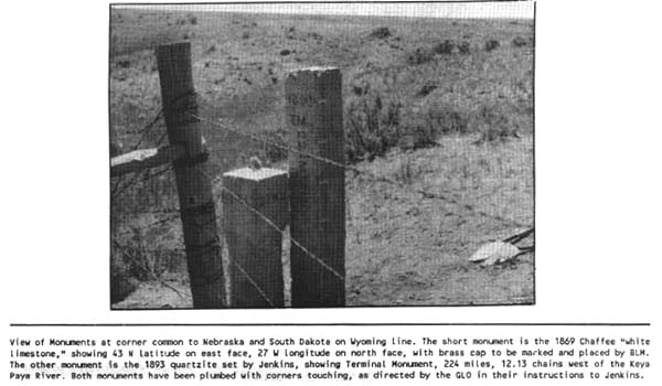
structure was still standing. Apparently the others have been destroyed. Oliver N. Chaffee in
his 1869 survey for the Nebraska-Wyoming line set the first “white
limestone monument”. The "27o W. L." inscribed
on the north face means longitude 27o west of Washington, D.
C.. The Washington,
D. C. system of measuring longitude was practiced between 1850 and 1912.
Today, longitude is measured from Greenwich, England, and this location is
approximately -104o. We see "138M, 22 chs,
67 lks" on the south face. This means 138
miles, 22 chains and 67 links north of Point of Beginning, the SE corner of Wyoming.
The
northern Wyoming-Montana borders, at time of its identification stone Cairns were placed along the separation line.
Early survey records identified that these Cairns were seven feet in diameter.
One was located in 2000 after ten years of research, and about four feet of its
structure was still standing. Apparently the others have been destroyed. Oliver N. Chaffee in
his 1869 survey for the Nebraska-Wyoming line set the first “white
limestone monument”. The "27o W. L." inscribed
on the north face means longitude 27o west of Washington, D.
C.. The Washington,
D. C. system of measuring longitude was practiced between 1850 and 1912.
Today, longitude is measured from Greenwich, England, and this location is
approximately -104o. We see "138M, 22 chs,
67 lks" on the south face. This means 138
miles, 22 chains and 67 links north of Point of Beginning, the SE corner of Wyoming.
When Chaffee set the monument, he wrote in his field notes the
following: "It is surrounded by a mound
of earth and stone 7 ft. in diameter at its base, 6 ft. in diameter at top and
3.5 ft. high. It stands in a small broken hollow without any natural
objects available for witnesses and nothing striking to the attention.
The surface rises towards the N., E., and W. and furnishes nothing that would
attract attention or furnish material for a sketch. The soil is clay of
the poorest quality." [Unfortunately, the picture doesn’t show
the Cairn base.]
In surveying across vast distances, it was not unusual
for the surveyors to construct huge stone platforms (Cairns) that
were over 100 feet high, upon which they placed their  instruments
for measurement.
instruments
for measurement.
Monument 40, located on the
Mexican Border west of the Rio Grande was
constructed from pre-cut stone to form an obelisk. It was restored in
1892-1894 under the direction of Dr. DH Payne, working for the US. Photo from NARA.gov files.
Indian and other Trail Markers
Indians have been reported to mark some trails with
stone Cairns, but the practice was not wide spread, as most knew where they
were traveling, and additional navigation guides were not required. These were
generally a loose collection of stones, gathered in a circular pattern, and
simply piled together in a conical shape. Some of these Cairns were used as drop-off points for
letters and other pieces of information to others who would pass by at a later
time.

Picture by Bill Múnoz.
This is one of three rock Cairns
identified as the “Indian Post Office” site, were made by the Nez
Perce Indians, and are on the highest point of the Lolo Trail. Clark, in 1906 passed by these rocks and didn’t
make reference to them in his diary. They are almost natural in shape, and can
be easily overlooked to a passerby. There function hasn’t been
established, although some believe they were created so that travelers could
leave messages; but this is highly doubtful.
Other Cairns,
located on the Nee Me Poo trail used by the Nez
Perce, are considered sacred to their tribe, and are similar in nature. Many of
these were vandalized in 2000, and the US
Forest Service is trying to rebuild them from
old photographs and drawings in their possession.
It should be noted that any vandalism of a Cairn is a
violation of the Federal Archeological Resource Protection Act.
“The so-called medicine wheels, stone patterns on the ground, may be
the most familiar structures, believed to have been built by the Plains Indians
in the West. The wheel in the Bighorn Mountains, northern Wyoming,
consists of cairns,
spokes and a rim. The number of spokes is close to the number of days in a
lunar month. Two cairns
can be used with the central cairn to sight the sunrise and sunset at the
summer solstice. Other cairns
can be used to sight Aldebaren, Rigel
and Sirius in the following way. The heliacal rising of Aldebaren
marked the summer solstice at the time the wheel was believed to have been
built, 200 to 400 years ago. Then, Aldebaren would
have been visible only a few minutes before the predawn glow from the Sun
washed it out. Twenty-eight days later, Rigel would
rise in the same way over a second line of cairns. Sirius would repeat this pattern over
a third line of cairns
28 days after that. The odds against chance alignments to the measured accuracy
have been calculated at greater than 4000 to 1. These solar alignments would
have been useful for millennia. The wheel resembles the plan of the Cheyenne medicine lodge, which was built to
celebrate the Sundance ceremony, the most important Plains Indian ritual held
in the summer, and practiced at the summer solstice by some. The wheel may have
been used to mark the calendar, especially the summer solstice, so that the
Sundance ceremony could be timed to correspond with the solstice. It is 80 feet
in diameter; comparatively small to others that existed on Crow Reservation
land in Montana
and Canadian soil.
One theory is that the wheel was created perhaps as
a “mass fasting” site, where six or seven warriors could perform
the fasting ritual together. On the Northern Cheyenne Reservation, next to the
Crow Reservation, there is a ringed site about ten feet in diameter, and three
feet high. Here it was recorded that seven Cheyenne men
fasted together.
Early discussions with the local Indian tribes
indicated that none of them could explain about the wheel’s past. This
was according to the Crows, Sioux, Blackfeet, Shoshone and Bannock tribal
members.
There are other medicine wheel sites east of the Rockies, across the Great Plains, and primarily north of the Bighorn Wheel.
They appear to have been constructed above about 45° latitude. Ten have been
found in Saskatchewan and at least 30 in Alberta. One of the most noteworthy Canadian
wheels is at Moose Mountain, Saskatchewan,
an area that was associated with the sky in Native legend. With five spokes and
no rim, its structure is simpler than the Bighorn Wheel, and may be an earlier
version. It is twice as large in diameter. The significant point is that it
contains the same number of cairns and in the
same relative positions as the Wyoming
wheel. The cairns show the same alignments with Aldebaren,
Rigel and Sirius, but for 2000 years ago, due to
precession. Its age has been verified by radiocarbon dating of charcoal at the
bottom of the central cairn where the ground was burned before construction.
The evidence is that the fire occurred about 2600 years ago. Incidentally, one
of the cairns
would have aligned with Capella when it was far
enough south to rise and set. For several hundred years this star would have
been an ideal marker for north. At the end of the summer solstice sunrise spoke
there is a small Sun symbol made of stones.
This Sun symbol has been found at two other candidates for astronomical
wheels in Saskatchewan.
More than half of the wheels examined in Alberta
have spokes or other features that align within 2° of sunrise at the summer
solstice. They also tend to point to the rising places of Aldebaren,
Rigel and Sirius. The ages of these wheels are almost
completely unknown. Medicine wheels in Canada are theorized to have been
built by different peoples over a long period of time. The most elaborate
structures appear to have astronomical associations.
The Wichita Indians of Kansas had structures, known as council circles that
were unique to Great Plains archaeology. They
are the main feature at five sites. Consisting of a central mound surrounded by
a ditch, most are situated on a ridge with a clear view of the horizon. An
observer positioned strategically at one circle could see other circles, as
well as the winter solstice sunrise. Another position revealed the summer
solstice sunset on the horizon. Human bones have been discovered at two sites.
Their presence may suggest that sacrifice was included in a ceremony held at
the time of the solstice. The Pawnees of Nebraska are known to have sacrificed
a female captive during their Morning Star ceremony, held in summer, and
usually when Mars rose in the east. The ritual was meant to ensure fertility
and successful crops. This event may have been a solstice ceremony, since a
version without the sacrifice was performed at the time of the winter solstice.
The priests to observe the positions of the stars and constellations through
the door and smoke hole sometimes used the Pawnees’ earth lodge.
Observations of the sky guided the timing of ceremonies for a people who had no
calendar but who did recognize a ceremonial year. Their year began with the
First Thunder ceremony, around the spring equinox, and the evening star was
significant. If past years were referred to at all,
they were linked to an unusual event.
“

This is a typical Cairn that one might see as they trek
along hiking trails. Some are placed with a specific purpose in mind; others
are just a collection of piled rocks. Often, hikers and hunters like to shoot
at these structures to prove their skill and bravery.
The Forest Service also places small rock Cairns along the maintained trails as route
identifiers, and they are often listed in their guides. Many are set in
concrete.

This monument is located on top of the hill at Horse
Haven Trail, on the south slope of the West Pryor’s.
There are numerous abandoned uranium mines in the area.
It is about two feet in diameter, and six feet
tall. [View looking south.]
The Crow Indians formed various types of rock piles that are
associated with Tribal Warfare, Markers for fallen warriors or enemies,
noteworthy feats, battlegrounds, shrines and hero’s monuments. They were
scattered across the county for many years until the land they rested upon was
plowed. Most of these monuments are considered sacred; so their precise
locations or pictures are not provided. Some of the more noteworthy ones are:
- At
Pryor Gap a neat row of stone piles are set along the roadway
commemorating a great battle against the Arapaho that occurred there. It
is now a tribal shrine. Passer bys add stones to the small piles for safe
passage. Several of the mountain passes in the area have such markers.
- At the
north end of Pryor Gap, located a short distance from the last mound
marking the battle, denoted the place where Medicine Crow rode in between
two fleeing Arapaho warriors whom he killed just as his horse was shot.
Farming has destroyed this monument.
- About
¼ mile southwest from the southernmost pile of Pryor Gap markers, and on
the other side of Sage Creek (at the foot of Arrow Rock) are three rock
piles. This is where the Crows offered rocks and beads to the mythical
Little People. Some braves would shoot arrows into the cliff crevasses.
- At Wolf
Mountain a large pile
of rocks was created that depicted the exact spot where Yellow Leggings
was killed. This was at the north end of the mountain range.
- A rock
pile at the base of Skeleton Cliff, near where the Boothill is located,
was a place where a shrine was created. This gave honor to those who died
in the mid 1840’s from smallpox. Indians who passed by would pick up
another stone, spit on it, and then place onto the pile in sacred memory
of the event that killed so many of the Crow tribe. This action would
hopefully keep him safe.
- A
trail marker (ring) is located midway between Warren and Bowler, on the
Indian - - Bridger Trail, leading to Pryor Gap.
- A
trail marker (ring) is located about one mile northwest of Bowler,
indicating track of the Bridger Cutoff Trail, before reaching Pryor Gap.
- A
trail marker (ring) is located on the Bad Pass Trail, near to the
Montana-Wyoming border crosing.
.
Spanish Boundary Marker
 Pictured here, is the very last one found at
the Northern end of the mountain range. It says several things that were
figured out, of which one of them is "Turn Around, U-TURN, Go-Back,"
(You've Gone To Far). Trial and Error has led the author to these conclusions,
although there is another message here. These are not like the rock cairns that prospectors put up for their
Discovery Markers or Boundary Markers
Pictured here, is the very last one found at
the Northern end of the mountain range. It says several things that were
figured out, of which one of them is "Turn Around, U-TURN, Go-Back,"
(You've Gone To Far). Trial and Error has led the author to these conclusions,
although there is another message here. These are not like the rock cairns that prospectors put up for their
Discovery Markers or Boundary Markers
Sheepherder Monuments

These Cairns are of various shapes and sizes, and as stated
earlier, their origins in the South Hills areas are unknown. They are similar
to the Alaska
boundary marker, but not constructed with strength retaining bands (large
stones) halfway up. This one at Buster Creek is located above the Bozeman
Trail, east of Beauvais Creek on reservation land,
east of South Hills.
The construction is formed from a random pattern,
sloping inward, and without regard for structural integrity. The stones are
simply placed on top of each other in a random fashion. This one is conical and
about seven feet tall.[1]

This is the Cowley Boundary Marker Cairn, located
north the town of Bowler.
Picture was taken by Rene’ Flood, who is standing along
side of it. It is about 3 ft square and approximately 5-1/2 ft tall. [Some
refer to it as the “Bowler Cairn.”] It is about 1-1/2 miles north
of the Cowley Airport,
and has a GPS location of: 44º 56’ 19.5” N, 108º25’
40.9” W. The elevation is 4,290 ft.
It sits among numerous mining claim markers. The originator has not been found,
but it appears to be a location marker for the mining claims on the hillside
below its location. There are two section-range boundary markers (wooden posts)
nearby this location. All of the mining claims are marked by white posts with
coded identification.

Pictured is the Four-Corners Cairn
The Cairn is located about 100 yards west of the crossroads
in Pryor Valley.
View looking north, with Monument Trail in the distance. It is about one mile
south of the Fourth-of-July mainstream flow, and is placed at the head of one
of the creek’s feeder south-fork streams.
The Cairn is about six feet tall, and three feet in diameter
at the base.
Although listed as a Sheepherder Monument,
it might well be the Trail Marker on a junction path to “Monument
Trail.”
The Silent Guide Monument

An early sheepherder, to mark a waterhole that never went
dry, built the Silent Guide
Monument
in the late 1800s or early 1900s. Made of flat stones, the guide originally
stood fourteen feet high, and could be seen as far as thirty-five miles away.
During the range feuds between cowboys and sheepherders, cowboys would
sometimes rope the guide and pull it down, reducing it to a pile of stones.
Once, a sheepherder grew tired of this irritation and climbed the pile of
stones with a rifle and dared the cowboys to knock it down while he was there.
As homesteaders came into the area they developed wells and other means to
acquire water and the guide lost its importance. The guide fell over several
times and was rebuilt by locals, who decided to reset the stones permanently.
In 1924, the stones were cemented together and the monument was dedicated by
the South Dakota Historical Society. The monument can be seen eight miles west
of Philip.
The Barga Monument

The stone CAIRN seen in
this photo taken in about 1900 shows one of the cairns that were built
in the Pequaming area of Baraga County.
The stone structures were built for some unknown reasons by persons prior to
the arrival of the white persons into the county. The height of the cairn
can be seen by the man standing along side of the stone pile. The cairns
were destroyed by the persons that were logging the area in the early 1950s and
today only the stones, scattered on private property remain.
The Twin Monuments
and Local Trails
There
were two rock- cairns
(Monuments) set on the north edge of the South Hills’ rim rock areas
overlooking Monument Creek in Section 5, Township 4 South, Range 25 East. They
are called “Twin Monuments”, and several pictures have been
displayed in the Billings
Gazette over a span of about 80 years. William Doss first homesteaded this land
in the early 1900’s, and city records indicate he arrived here between
1915 and 1916. He received his Land Patent on December 5, 1921.
His brother Samuel, homesteaded on the property to the east. They are located directly on the mid section
line extension of T3 S, R25 E, Section 32; approximately 160 feet south of the
Township boundary line. The
survey conducted by Carl
Gleeson August 14, 1903, provided no indication of their existence. Neither did
the survey conducted by Otis
Ross, Oct 29, 1913.
 The northernmost Cairn was
vandalized as more homesteaders entered the plateau area, with some
pieces apparently used in building foundations, others taken just for
curiosity.
The northernmost Cairn was
vandalized as more homesteaders entered the plateau area, with some
pieces apparently used in building foundations, others taken just for
curiosity.
 Standing next to the Cairn
(the remaining Twin monument) is Vernon
Drake, who authored the interest and development of the article presented
herein. He is also responsible for the reconstruction of the vandalized Cairn,
using old photographs as the guide. Note the structural retaining ring of large
rocks placed about halfway to the top. Several of these pieces weigh over 300 pounds.
Standing next to the Cairn
(the remaining Twin monument) is Vernon
Drake, who authored the interest and development of the article presented
herein. He is also responsible for the reconstruction of the vandalized Cairn,
using old photographs as the guide. Note the structural retaining ring of large
rocks placed about halfway to the top. Several of these pieces weigh over 300 pounds.
There is a small bore-sight built into the cairn, at
about five feet above the base, and just off to the south of the centerline. It
has an aperture of about one-half inch in diameter, and it is aimed directly at
where a former cairn used to stand on the area immediately to the northwest of
Stratford Hill. This is on the direct route for the Monument Trail (McCormick
Trail), and leads to Red-Eye Smith’s Saloon. It is also part of the
Hog’s Back Road
to Bridger.
The
monument is visible for over ten miles from the south, east and west directions
from sites where old trails existed. It appears that from the out lying trails
one could see where to travel to get up onto the South Hills plateau, and then
into the Yellowstone River
bottom (Clarks Fork
Valley.) Construction of
the Twin monuments do not fit the pattern that was so evident for other types
of Cairns, especially those conical ones made by sheepherders to mark their
territory range borders. It stands at a GPS elevation of 3927 ft, at 108.33.391
and 45.41.217.
In
October 2000, a group of experienced masonry craftsmen and engineers
reconstructed the vandalized cairn, but it collapsed soon after. This
established the theory that sheepherders couldn’t have created them,
since the structural design is tougher to master than originally thought. It
would appear that the mass of the stone has to be directed toward the
centerline of the cairn to prevent outward collapse, as evidenced by the first
reconstruction failure. The cairn was rebuilt, using old photographs as a
guide, in the summer of 2002.
There
were several cairns
in the viewing vicinity, all about seven to ten miles distant, and apparently
served some purpose during the early 1900’s. In examining the placement
of these Twin Monuments, one can establish for a fact that they are at the
center of a series of trails. Why there were two has not been determined, nor
has who or when they were constructed been determined. They are positioned
about 40 feet apart, and at a true angle of N-42 degrees W. [Compass bearing is about 30 degrees.] This
alignment is not coincidental with the summer or winter solstice angles of the
sun. There location doesn’t appear to coincide with any of the early
territorial boundaries from the French, English or Spanish acquisitions.
However,
there is a close resemblance to the Crow Indian Boundary interpretation
resulting from their loss of 1,100,000 acres of land to public domain in
1878-1879. The Director of Geological Survey, on 10 June 1896 signed a treaty
with the River Crows establishing permission to survey their lands and
establish boundary markers in accordance with the same practice utilized in the
rest of the land. Stone monuments or posts placed at the corners were the
preferred method. The Indians were left with a central piece of land (Crow
Indian Reservation) that was bordered on the west by a ridge of rimmed rocks
that bordered by what is presently referred to as “the South Hills”
area of Billings.
The government (GLO-BLM) surveyed the strip of land between the reservation
line and the Yellowstone River,
and established corner markers for the sections and quarter sections; plus they
identified specific landmarks. Later, in the 1900’s they entered the
reservation land, and completed the surveys for the area. For the Indians,
their land now ended at the ridge of the rim rocks bordering the South Hills
west of Pryor Creek. The last edged rimmed area is at the site occupied by the
Twin monuments, and their angular placement parallels the reservation line
plotted by the surveyors, but located in the valley floor 1 ½ mile further to
the southwest. It is conjectured, that when Paul McCormick established his
grazing rights for100, 000 head of sheep on the reservation, along with brother
Frank who also had contracts for supplies on the reservation and at Fort
Custer, he might have ordered construction of the Twin Monuments, and the
numerous others that have been vandalized along Monument Creek, and the
ridgelines nearby. His son, Paul, was manager for the road and tunnel construction
operations that occurred between 1900 and 1905. His road crews would have been
well capable of constructing a rock cairn that would withstand the harsh Montana elements, and that could be used as a
marker for his lease-land holdings. Additionally, he traded extensively with
the Indians, was granted permission to construct roads through their lands, and
he transported great amounts of fresh produce, seed, and meat supplies to both
the men that were tending his sheep, and the reservation Indians themselves.
For that purpose he would need a series of roads that provided the easiest
access from his home base in Billings,
and the outlying communities within his vast route. He had the largest
freighting outfit in Montana and it would make sense to have visual markers
created to indicate where to travel during winter days, when the roads are not
visible; and to mark the territorial limits of the Crow Reservation as seen by
the Indians at that time.
It is also probable that the monuments were created
by the
Story-McAdow Freighters or other freighter operators when they
traveled on the Military
Bozeman Road
between the Yellowstone and Big Horn. There is
no mention of these monuments in any of the early survey field notes. They do
indicate water sources for stock is available at the site, and access routes
were created for cattle and other livestock to reach the water. These monuments
are halfway between water sources available from the rivers.
It is reported that the monuments were
actually constructed
by ranchers in the area, who had sheep holdings in the land below. This is being
questioned.
Or perhaps they were constructed to establish
directions to Red Eye Smith’s Saloon, collection point for freighters
supporting the Burlington-Quincy railroad, located at the top of McCormick Hill
on Monument Trail, or to be a Bridger signpost.
The
USGS maintains a vast collection of Territory, State
and International Boundary Marker files, but do not have any pictures of these cairns. Their design has been observed to be
very similar to several others created by the USGS
between 1900 and 1905 to mark boundary lines under their jurisdiction, but none
were recorded on film, but eyewitnesses recall their appearance. The key
element in the design is the incorporation of the structural band of
reinforcing large stones placed about four feet up. These retain the structural
load within the column, and not allow the forces to be exerted outward, which
would lead to their collapse. Unfortunately, no written record of the Monuments
has been located. These should be considered for Historical Preservation as a
National Archival item when their history has been satisfactorily identified.
BLM Land
Survey Comments
The
governmental surveys, taken between 1887 and 1913 do not make reference to these
monuments. The land survey notes prepared for the land west of the Yellowstone
River carry extensive
comments about the objects found during their surveys; but the lands east of
the river do not. The surveyor’s
and some of their significant comments regarding the “South Hills”
area follow.
George
Reeder (September 14, 1887)
Surveyed the north-south boundaries near the riverbanks, and no objects,
trails, roads, and buildings were recorded.
Samuel Burdock (April 26, 1890)
Conducted some minor boundary
line survey, no references to objects.
Philip Gallagher (June 10, 1891)
A treaty signed on December 8, 1890 created the
Crow Indian Reservation west boundary for their land deed. The boundary line was mapped to the land by a
survey that started in the north, and ran southward. This was strictly a method
to identify where the Indian land ended. Boundary markers were placed at
appropriate points using standard buried stone slabs, along with marking cairns
(about 1 ½ ft high.) although the survey passed across many Indian trails,
roads, creeks and near to cabins, there were no remarks about any of the
objects. Only the boundary was recorded.
Carl Gleason (August 15, 1902 to
August 14, 1903)
Conducted the detail south boundary line and ¼
section topographical markings (including Range 25 E and Township 3 S),
extending from the Yellowstone River
to the Crow Reservation west boundary. He placed a stone where the east
boundary of the government land stopped. There should also have been a previous
stone demarking the Indian west boundary at that point. He identified the road
leading from the south towards the summit at the junction of sections 27, 28,
33 and 34. Cottonwood Creek was defined (but dry), along with the ravines and
hills. He listed the land as 2nd rate, mountainous and consisting of
stony-clay. No timber. This survey took him a few feet south of where the twin
monuments are located, but he made no reference to them, nor was there any
buildings or fences reported.
Carl Gleason (August 18, 1903)
Established sub-division of the land in Township 3S,
Range 25E, and the southern boundary between it and township 4 south. He again
passed within 160 feet of the location where the twin monuments are located,
but no reference to them was made. The only object he reported is the road
(continuing from the south in lot #3 of Section 5), passing to the west of the
monuments by about 200 feet, then continuing passing northeast towards the
highest point in Yellowstone County.
[This summit would later be called Brazwell Summit,
after a town in Texas; and a stage – mail stop would be operating there
by Julia A Woods from 1914 to 1918.], then later it was referred to as
Stratford Hill. Blue Creek Road passed directly through
the Woods’ property at the summit of the hill, approximately 1/8th
mile east of Section 28’s center point.
Otis Rose (October 29, 1913)
Reestablished the section and ¼ section line boundary
markers. He identified Cottonwood Creek, and the road reported by Carl Gleason,
plus fencing and some fence posts. He reported that virtually all the land was
homesteaded, but no occupants were identified. There was evidence of a
considerable amount of prospecting, and the flow of natural gas was encountered
in the area west of section 7. The township had much evidence of the presence
of oil. In identifying the northern boundary of Township 4S, he simply accepted
the south boundary of Township 3S created some ten years earlier. He did not
report evidence of the twin monuments.
Origination of Wagon Roads
[Billings
Business Directory 1883-1884]
Before Montana had settlements in the Yellowstone
Valley area, Wyoming territory, southeast of the Big Horn Mountain Range, had a
district about 200 miles square, and was fed with water from the Stinking Water
River [Ruby River], Wind River and numerous other tributaries on the Big Horn
River. Residents who farmed and raised sheep and cattle in this fertile area
had to get their supplies from a difficult trip over nearly impassable roads
that connected with the Union Pacific Railroad. This was a distance of 400 to
500 miles. After the Indian wars were over [about 1878] the settlements at
Coulson, and other small towns on the Yellowstone
River sprang up. This led
to navigation and the bringing of supplies into Montana by boat. With the advent of local ranchers placing
huge herds of livestock, horses and sheep on domain land and Crow Indian
Reservation lands, these folks developed a series of roads that could
accommodate wagons. The distances to
Coulson, and eventually Billings,
were only half of that needed to reach the Union Pacific Terminals.
Near the northern borders of Yellowstone
Park gold and silver was
discovered. This led to the establishment of the Clark’s
Fork Mines. A smelter was built and the area needed better transportation. A
wagon road that cut through the Clark’s
Fork canyon areas was then constructed. This made Billings
the closest accessible point for the entire mineral region of the Clark’s Fork.
The Crow Reservation lies between The Yellowstone
River [150 miles], the Big
Horn River
and the Wyoming
Border. It comprises 6, 000,000 acres. There was strong sentiment [by the
settlers] that this reservation was too expensive for the needs of the Indians,
and legislation was initiated to reduce its size. This initiated the land
surveys and return of vast portions of the land to domain status. This act was
concluded and the territory was opened as a “Tributary of Billings” for minerals, cattle, sheep
& wool, and various agricultural products.
The need for transportation was considerable, and
an extensive network of wagon roads were developed. It is the when, the who,
and the where traveled that sparked the need to understand their
development so that the origination of the Twin monuments can be fully
ascertained. Many of these early roads
cut through the ‘natural’ contours of the land, and are still
evident today. The ranchers however closed most of them as the Reservation
lands were settled and fencing was initiated in full.
In July 1893, the editor of the Weekly Times took a
trip from Billings to Wyoming, passing through Pryor Gap. He
described the week’s journey with these comments:
·
Jim & I left Billings
on July 3rd, and crossed the Yellowstone
River at the Blue Creek
Ferry location
·
We headed south for Pryor Gap
·
We nooned at the
crossing of Pryor River
·
We passed the Catholic Mission and Chief Plenticous
(sp), arrived at a beautiful camp ground in Pryor Gap about 6 pm.
Comment: According the
early trails available for wagons, indicated as being in the area at that time,
it appears that they traveled almost due south from the ferry crossing,
following what is now called Hillcrest Road [located on the crest of the low
lying hills south of Billings] and onto the edge of the South Hills plateau
near or at the Twin Monuments’ location and Stratford Hill (high point of
Yellowstone County.) From there the shortest route would be to turn east and
start down McCormick’s Hill on Monument Trail for a short distance, then
immediately cut due south passing through Four-Corners [center of a vast open
range area between the plateau and the West Pryor Mountains], and straight into
the Pryor Mission and Chief Plenty Coups’ homestead locations. [They
could have cut down along Cottonwood
Creek Road, but that would take them in a southwest
direction, and add a significant amount of travel distance.] From there they
would have followed the Indian trail up into the pass.
Comment: The
search is still on for who actually constructed the monuments, and any
information would be greatly appreciated.

