butler county missouri bc-cem3
Cemetery Locations
| County:? |
Cemetery:Bethany Chapel Cemetery |
Out of Town: YES |
Road Number: "T" - T25N R7E SEC 20 |
Directions:According to the cemetery books, Duley Cemetery is sometimes referred to as Bethany Chapel Cemetery, T25N R7E SEC 20
In ordinary language, it looks as if it is off T Highway, going up to Wapappello Lake.
Submitter: Mary Collins
| County:?? Could be in Ripley |
Cemetery:GUMM or GOMMCemetery |
Out of Town: YES |
Road Number:Highway "B" |
Directions: Out of Poplar Bluff, travel highway 67 south to 160 west to highway "B", go south 3.2 miles.
A MAP accompanies this description
Submitter: JIMMIE CASSIDY
| County:Carter?? |
Cemetery:GRESHAM Cemetery |
Out of Town: YES |
Road Number:Highway "H" |
Directions: Out of Poplar Bluff, travel highway 67 north to 60 west. Take highway 60 west to highway 21 north about � mile make a right on "H". Follow "H", about 3 � mile. Cemetery on right. A MAP accompanies this description
Submitter: JIMMIE CASSIDY
| County:BUTLER |
Cemetery:MEMORIAL GARDENS Cemetery |
Out of Town: YES |
Road Number:67 |
Directions:Out of Poplar Bluff, trave highway 67 south about one mile. Cemetery on left side of highway across from the gold course.
A MAP accompanies this description
Submitter: JIMMIE CASSIDY
| County:BUTLER |
Cemetery:MOLE HILL Cemetery |
Out of Town: YES |
Road Number:64 |
Directions:Out of Poplar Bluff, travel highway 60 east to "B" highway, make a right turn continue to "AA." Make a right turn on "AA," and continue and cross highway 51. Map appears to change from AA to county road 64 when you cross the highway 51. At the chruch make a right turn and about � mile make another right turn into the cemetery.
A MAP accompanies this description
Submitter: JIMMIE CASSIDY
| County:BUTLER |
Cemetery:MOUNT ZION Cemetery |
Out of Town: YES |
Road Number: W |
Directions:Out of Poplar Bluff, travel highway 67 north to "W," make a right turn on "W." Follow this road to the church and cemetery.
A MAP accompanies this description
Submitter: JIMMIE CASSIDY
| County:probably Wayne county |
Cemetery:NEW OAK HILL Cemetery |
Out of Town: YES |
Road Number:Near O |
Directions:Out of Poplar Bluff, travel highway 67 north to highway "W," make a right on "W," to highway "O," continue to county road on the left, follow this road to the cemetery. Highway "O," makes a bend where the gravel road turns.
A MAP accompanies this description
Submitter: JIMMIE CASSIDY
| County:BUTLER |
Cemetery:OAK HILLCemetery |
Out of Town: YES |
Road Number: oak hill |
Directions:Out of Poplar Bluff, travel highway 67 north to "W," highway, make a right turn continue to Oak Brair (Briar) estate. Turn right to OAK HILL.
A MAP accompanies this description
Submitter: JIMMIE CASSIDY
| County:New Madrid county |
Cemetery:PORTAGEVILLE Cemetery |
Out of Town: YES |
Road Number: near 162 |
Directions:Out of Poplar Bluff,Out of Poplar Bluff, travel highway 53 to highway 62 west, make a left on 62. at junction 62 and 162 make a right to Portageville. Make right on 2nd black top street after coming into town. cemetery is on this street near the rail road crossing.
A MAP accompanies this description
Submitter: JIMMIE CASSIDY
| County:BUTLER |
Cemetery: Red Hill |
In Town:�
Out of Town: YES
Nearest Town: Nellyville |
Road Number: Near state line | Directions: It is my understanding that Red Hill Cem. was south of Neelyville. It could very likely be in Clay Co. Ark. Also was told that some years back it was washed away in a big rainstorm and that most all coffins were washed away.
Submitter: Joe Kallbrier
| County:probably Wayne county |
Cemetery:ROBINSON Cemetery |
Out of Town: YES |
Road Number:V |
Directions:Out of Poplar Bluff, travel highway 67 north to highway 60 west to highway "V," make a right turn go past highway 49 intersecton to a concrete bridge. Turn left on gravel road just past the bridge. Note: this map led me to think this cemetery may or may not be in Butler county, as you drive past Elisnore High School when you turn on Highway V. probably Wayne county as I find highway 49 in Wayne county and not in Carter county which is where Elisnore is located. [m.h.]
A MAP accompanies this description
Submitter: JIMMIE CASSIDY
| County:BUTLER |
Cemetery:RUMBAVER Cemetery |
Out of Town: YES |
Road Number:near old 60 e. |
Directions:Out of Poplar Bluff, Travel old 60 east to Tom's Lumber shed make a left to Rumbaver. This turn leads to a stop at a dead end street, make a left to the 1st gravel road, make a right turn an dgo up a hill into the cemetery.
A MAP accompanies this description
Submitter: JIMMIE CASSIDY
| County:BUTLER |
Cemetery:SHEPHERD Cemetery |
Out of Town: YES |
Road Number:Township Line Road |
Directions: Out of Poplar Bluff, travel highway 67 north to PP highway. Follow PP highway to Township Line Road. Make a left and continue 1 or 1 � miles . Cemetery is on the left by a church. A MAP accompanies this description
Submitter: JIMMIE CASSIDY
| County:BUTLER |
Cemetery:SHILO Cemetery |
Out of Town: YES |
Road Number:412 |
Directions: Out of Poplar Bluff, travel highway 67 to 60 west. Go 6.8 miles on highway 60 to OLD highway 60, make a right on old 60. (Landmark:Bethany Chapel is at this junction.) Continue old 60 to county road 412. Make right on 412, follow this road 2. 5 miles at a fork with a low water bridge make a left. follow this road across another creek bridge, and around two bends, the road takes you into Shilo Cemetery.
A MAP accompanies this description
Submitter: JIMMIE CASSIDY
|
County:BUTLER |
Cemetery: Simms Graveyard |
In Town:
Out of Town: YES
Nearest Town: Neelyville |
Road Number: Unknown |
Directions:
Submitter: Mary Guffey
.
| County:BUTLER |
Cemetery:SPARKMAN Cemetery |
Out of Town: YES |
Road Number:nearest tt |
Directions: Out of Poplar Bluff, travel highway 67 north to "PP" west. Continue to junction "TT," make a right onto a gravel road. Go down a hill to the cemetery, which is across from Good Hope church.
A MAP accompanies this description
Submitter: JIMMIE CASSIDY
Sparkman Cemetery Transcriptions and Photographs
| County:BUTLER |
Cemetery:SPRING CEMETERY and CHURCH Cemetery |
Out of Town: YES |
Road Number:BB |
Directions: Out of Poplar Bluff, travel highway 67 south to 160 west toward Fairdealing, to "BB", make a right on "BB." Drive past a rock house and garage on the right the chruch and cemetery will be on the right.
A MAP accompanies this description
Submitter: JIMMIE CASSIDY
| County:BUTLER |
Cemetery:THREE SPRING Cemetery |
Out of Town: YES |
Road Number:nearest 523 |
Directions: Out of Poplar Bluff, travel highway 67 north, to the end of the four land part, make a right turn on old 67 and go north to county road 523, turn right. About 2 � miles to cemetery sign is on the left side of the road, make a left at the sign, go up a hill about 1/4th mile to the cemetery on the right
A MAP accompanies this description
Submitter: JIMMIE CASSIDY
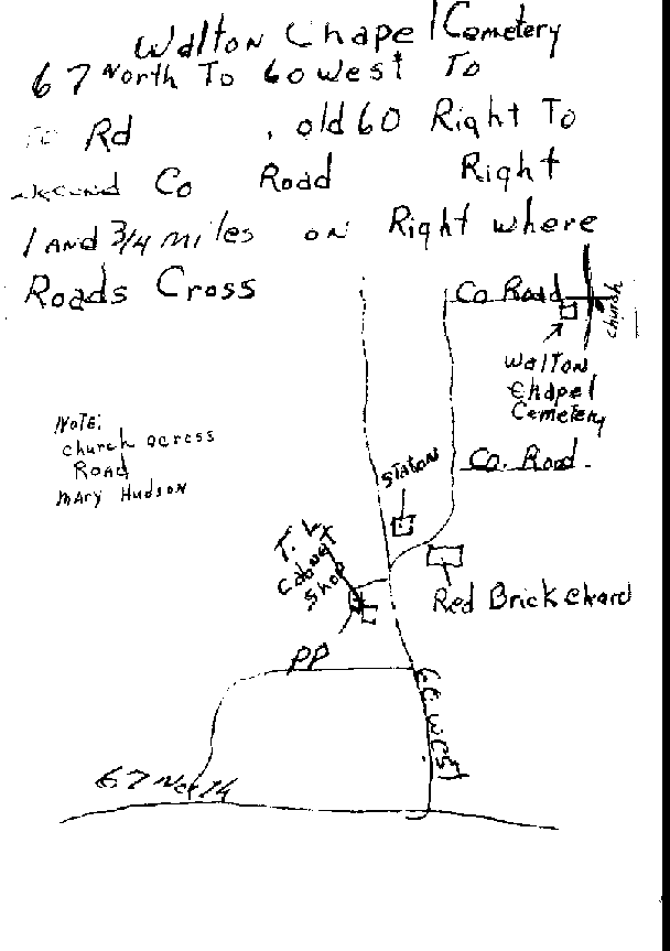
| County:BUTLER |
Cemetery:WALTON CHAPEL Cemetery |
Out of Town: YES |
Road Number: |
Directions:
Walton Chapel Cemetery is located in the northwest corner of Butler Co., MO, adjacent
to Walton Chapel Church. From Highway 67, go west on US 60 6.9 miles, turn right onto
county road 415 and go 3.3 miles to county road 417. Turn right and go 1.5 miles. The
cemetery is at the junction of county roads 417 and 410. Surveyed by Bill Johnson
[email protected] July, 2000.
Surveyed by Bill Johnson July 2000 - Tombstones Transcribed
------------------
The Walton Chapel Cemetery is located about three mile on up Co. Rd. 417 at junction 410. I know we used to go by the Shiloh Cemetery on the way to the Walton Chapel Church and the cemetery is right across the road. This cemetery is at a gravel cross roads and the church is across the road from the cemetery. A beautiful place on top of a hill.
A MAP accompanies this description
Submitter: KEN WISECARVER and JIMMIE CASSIDY
| County:WAYNE |
Cemetery:WAPPAPELLO Cemetery |
Out of Town: YES |
Road Number:Highway "T" |
Directions: Out of Poplar Bluff, travel highway 60 east to highway "T". make a left to Wappapello Dam. Cross the dam. Cemetery is on the 1st gravel road to the right.
A MAP accompanies this description
Submitter: JIMMIE CASSIDY
|
County:BUTLER |
Cemetery: Hogg |
Headstones: Transcribed
|
In Town:
Out of Town: YES
Nearest Town: Poplar Bluff |
Road Number: Oak Grove Rd. |
Directions: On Parkin Place, 600 ft s.w. of New Covanant Ch. on the now abadoned Old Fredricktown, Rd.
Located at NE 1/4 of the SW 1/4 Sec 30 Range 6 E Township 25 North App. 600 feet south of Oak Grove Rd. Touching the sec. line of sec 29.. It is on family property, My Grandfathers Old Place, owned now by my uncle. An acer has been survayed off and corners marked.
I have have full excess to it. And would be happy to take anyone there at almost any time
Submitter: Gary Parkin - Names from Headstones
This page created
and placed here by
Mary A. Hudson
[email protected]
April 1999 for MOGenWeb |

This Page sponsored by
Rootsweb |
Return to:
Butler County Web Site |
| To contact the State CoordinatorYvonne James-Henderson - [email protected]
|
Since April 1999
You are our [an error occurred while processing this directive]
visitor -- thanks for stopping by!
|