1940 Map of Carter County With Election District Boundaries
It should be noted that in 1937, the year this map was drawn, few Carter County roads, other than US 60, were paved.
 Click here for a larger image of this map


Note that it is not apparent on this map that in 1940, the road through Henderson Branch ran alomg
the east side of Henderson Branch Creek. Today, Route 2 runs along the west side of the branch.
The original road still exists, but only serves the local traffic to the homes along the branch.
Two schools are indicated along Henderson Branch. I believe one of the old school buildings may
still be standing (to the east of the current Route 2.
As one would expect, the roads in the Trough Camp area were substantially re-routed when I-64 was
routed through it in the 1960's.


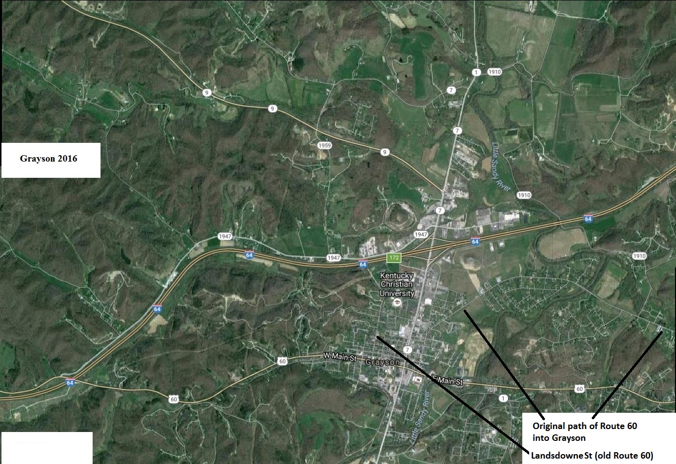
Note that old Route 60 did not enter Grayson from the east along Main St. as it does today.
Originally, Route 60 went to the north of Town Hill and entered Grayson about a quarter mile north
of Main St., came down Robert and Mary St., then turned west onto Main St.
Later a road cut across the flank of Town Hill was made, and Route 60 took the more direct route
along east Main St. that we use today. Note also that Route 60 didn't run out west Main St., but rather
made a U-turn north and ran up Landsdowne St., and then west along what is now Route 1947. This rather peculiar
routing may be explained because it was more direct (between Cannonsburg and Olive Hill), and perhaps there was
some hope that Grayson would be encouraged to develop along the more northerly route. Apparently it was soon
recognized that the citizens of Grayson had no such intention, so the rather peculiar dip down to Main St.
and back was added, apparently after the acquisition of the right-of-way for the northern route had been made.
Of course, today US 60 does follow a route out west Main St. for a substantial distance, before passing over
I-64 and joining the pre-I-64 routing of US 60 a couple of miles west of the Grayson interchange. The "directness"
of the original US 60 routing through eastern Kentucky was obviously compromised by a need to avoid major topographic
obstacles (the hills between Olive Hill and Grayson), something that the more generously funded I-64 project was not obliged to do.


Somewhat curiously, there was no direct route between Grayson and Pactolus in 1940.
The earliest maps of this part of Carter County show a direct trail north from Grayson leading to
Greenup, Ky. and the Ohio River. This 1940 map indicates an inexplicable jog to the west by Route 1.
Although the steel girder bridge at Pactolus drawn on the 1940 map across the Little Sandy River has been replaced by rather generic concrete span,
the stone abutments of the original bridge still stand. They are a few yards downstream from the newer bridge.
Pactolus was originally noted as a site for salt extraction, and later as a mill site. Nothing remains of either enterprise.
